
We continue the wintry stretch of weather to start the week with yet another round of accumulating snow. A slow warming trend then takes hold through the rest of the week. Could there also be another late week snowstorm? Read on to find out more!
Another light snow event Monday evening
With six weeks of dry weather to begin 2020, you surely didn’t think winter was over already did you? Today we are tracking yet another weak snow event, our fourth in just the last eight days (#1, #2, #3). A weak embedded area of low pressure is centered over northwest Utah by early this evening (below). A trough axis is oriented southwest to northeast from eastern Nevada into southern Wyoming (green dashed line). We are south of this trough axis tonight and can expect weak impulses of energy to the region through the evening into early tomorrow morning, providing just enough lift for snow. Before this happens, we will see sunshine for the first half of Monday and then clouds filter back in. Expect highs in the lower 30’s with snow cover on the ground region-wide.

Along the trough axis, a convergence line of moisture is positioned just south of the trough (below red dashed line). Note that south of the axis shown below there is above average moisture (green shading) across the Front Range and southern Colorado. To the north of the axis, drier air is present as depicted by the brown shadings. Good moisture is thus in place tonight for measurable snow.

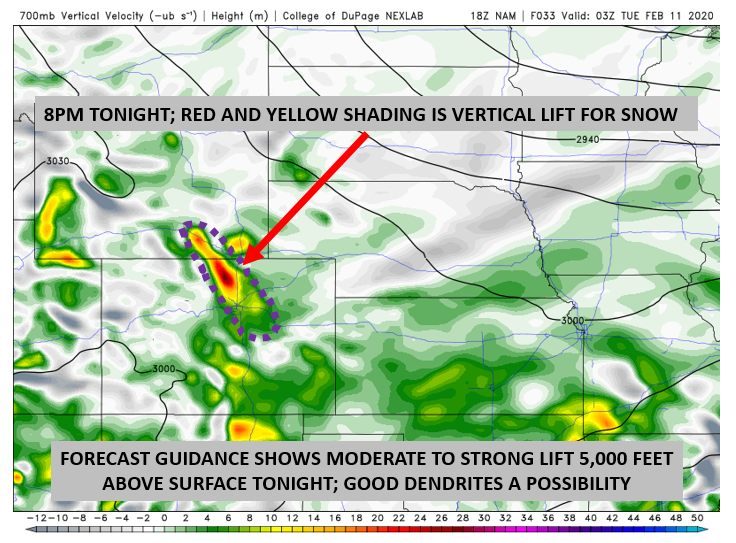
While there is little to no upper-level jet forcing, there will be lift tied to another approaching cold front (frontal lift). Shown below is the 700 mb vertical lift. Areas that are shaded yellow and red denote upward vertical motion. This is conducive to the development of snow bands. Note also that the lift is concentrated along and near the Foothills. There is likely an upslope component to this pattern of lift shown below. In addition, a large portion of the atmosphere will be well saturated to support favorable dendritic snow growth producing embedded pockets of moderate to heavy snowfall Monday evening!
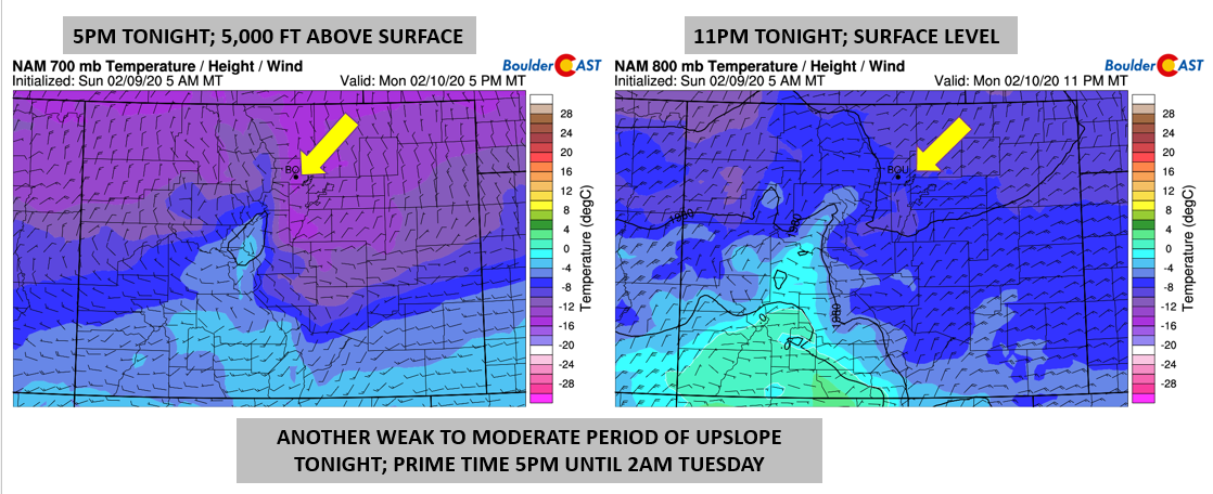
Lastly for this storm, the upslope extends from the surface (below right) to roughly 5000 feet above us (below left). While the upslope component is not very strong (5-10 mph at best), it persists from about 4PM today into 4AM tomorrow. That combined with above average moisture and favorable lift in the mid-levels will produce a nice swath of light snow over the Denver Metro area.
We think the first flakes may fall as early as mid-afternoon, especially for the northern tier of the Front Range (Fort Collins to Loveland). However, snow will most likely hold off until right around rush hour for most of us, ending before sunrise Tuesday morning. This is when there is overlapping upslope, mid-level lift, frontogenesis, and moisture.
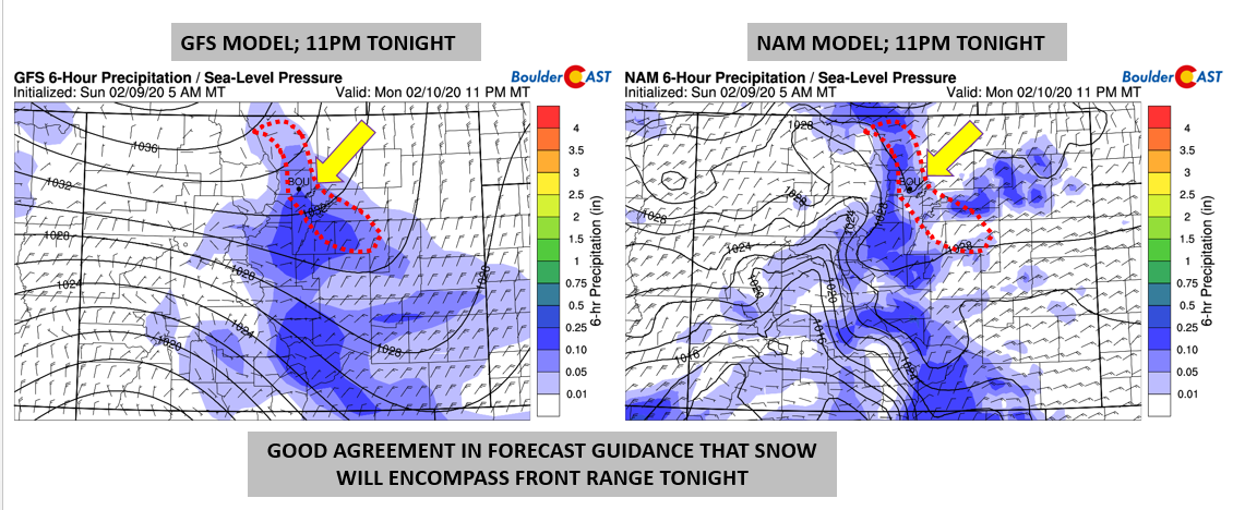
This is not a major storm by any means… but as we saw yesterday, there doesn’t need to be that much forcing given the moisture in place to wreak some havoc on travel across the area. There is good agreement in the forecast guidance that all of us are going to see light snow accumulations. The favored areas will be the Foothills, Boulder, and southern and western sections of Denver. The snowfall prediction from the HRRR model shown below looks spot-on in our opinion given the setup.
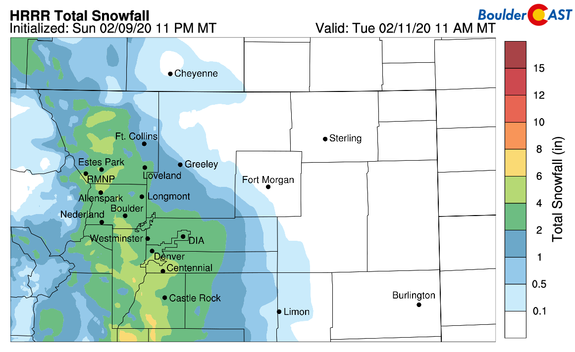
HRRR model-derived snowfall forecast through Tuesday morning
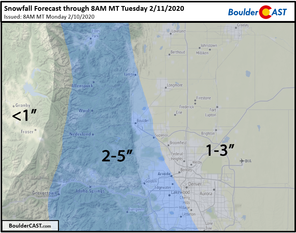
Our snowfall forecast for the event is shown below. We are looking at a broad brush of 2-5″ in Boulder and Foothills, with slightly lower totals of 1-3″ in the rest of the Denver Metro area and Plains. In general, this will be a light snow event, but we do expect embedded pockets of moderate to heavy snowfall to occur Monday evening, so do use caution if traveling. Monday’s evening commute should just barely be okay with the worst of the snow coming 7PM and after. However, Tuesday’s morning commute could be slick in spots.
And for the gamblers out there, here’s the latest probabilities….

A “lull” Tuesday and Wednesday
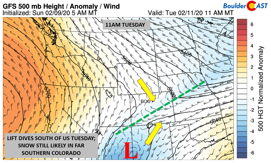
Come tomorrow, the snow will have ended and cloud cover should give way to sunshine for the remainder of the day. The trough axis will have pushed south of our area into far southern Colorado (below). However, some light snow is still likely in that part of our beautiful state. Despite the sunshine, highs remain cold tomorrow in the lower to middle 30’s thanks to the snow cover.
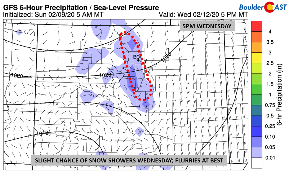
On Wednesday, the pattern is overall quiet, but another cold front slides down in the northwest flow. The front is weaker than Sunday’s and Monday’s, but it will keep us on the cold side once again. Highs to remain in the 30’s with partly to mostly cloudy skies. There is another chance of very light snow (below), but overall we are not expecting much, if anything. Flurries to a dusting of accumulation looks to be the best bet at this point.
Late week warmth and a possible snowstorm?
After the middle of the week, warmth looks to take over, albeit short-lived. The low-level flow (below) turns southwesterly, allowing a nice surge of warmer air to penetrate Colorado. This warmth will be moving northeast from Utah and Arizona during the day on Thursday and won’t fully be realized until the evening. Thus, we should warm into the upper 30’s or lower 40’s (still below normal for mid-February mind you!). By Friday, highs should be warmer though getting close to 50 degrees.

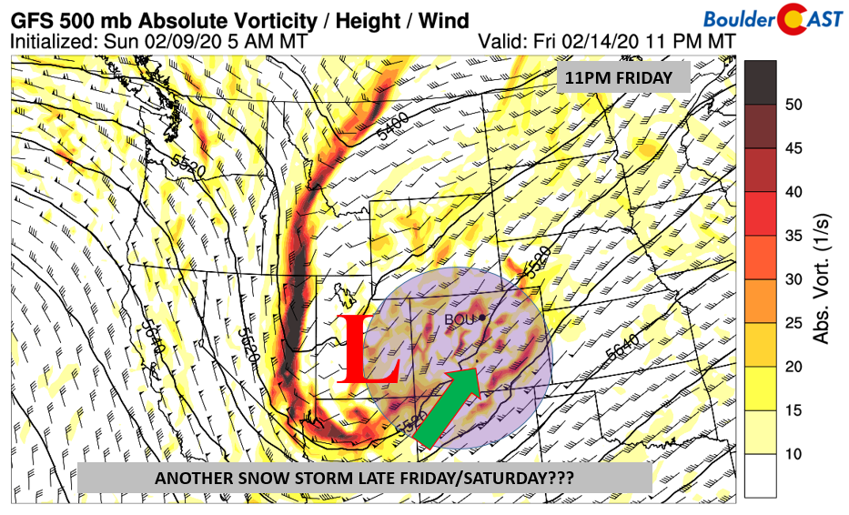
However, as touched upon, the warmth will be short-lived. Current model trends are showing yet another storm system taking aim on the region (below). While it’s too far out to make any confident predictions, there is a chance of snow yet again to start the weekend. If this verifies, it would also return us to that winter feel.
Forecast Specifics:
Monday: Some sunshine early, but clouds will move back in as the day wears on. Highs in the lower 30’s on the Plains and middle 20’s in the Foothills. Light to moderate snow develops in the late afternoon/early evening and ends before sunrise Tuesday. Snow totals of 2-5″ in Boulder and 1-3″ in Denver.
Tuesday: Some early morning clouds turning sunny with highs in the lower to middle 30’s for the Plains and middle 20’s in the Foothills.
Wednesday: Partly to mostly cloudy with a chance of snow flurries late in the day. A dusting or less of accumulation expected. Highs in the upper 30’s on the Plains and upper 20’s in the Foothills.
Thursday: Sunny and warmer with highs in the upper 30’s for the Plains and upper 20’s in the Foothills.
Friday: Mostly sunny with increasing clouds. Highs near 50 degrees on the Plains and upper 30’s for the Foothills. Possibly a slight chance of snow late in the evening/overnight into Saturday.

High Country: Snowy conditions persist for the higher terrain today with light accumulations possible, generally 1-4″. Southern Colorado should stay in the white stuff tomorrow as well. Drying takes over Wednesday and Thursday with just slight chance of snow showers in northwest Colorado. More sizable snowfall likely returns Friday and Saturday to the Mountains with moderate accumulations possible (6+”). Check our PowderCAST page for always-updated weather forecasts for all of the Colorado ski resorts.

DISCLAIMER: This weekly outlook forecast is created Monday morning and covers the entire upcoming week. Accuracy will decrease as the week progresses as this post is NOT updated. To receive daily updated forecasts from our team, subscribe to BoulderCAST Premium.

.
Spread the word, share our forecast!


You must be logged in to post a comment.