
After a cold start to our week to end the month of December, the weather turns milder as we ring in the New Year. Don’t get too cozy…a return to winter-like temperatures will ensue during the latter part of the week. We also discuss the little bit of snow over the weekend which produced just enough to bump 2019 into Boulder’s top 5 snowiest calendar years.
Snow totals from Saturday, the last of a very snowy 2019
You may not have known it, but we were dangerously close to concluding the month of December with extraordinarily meager monthly snow totals in Boulder (0.7″) and Denver (nada), nearly cracking the “Top 10″ lowest on record for the month. Fortunately, the single quick-hitting storm over this past weekend has robbed us of this fate.
Our final forecast for the event called for 2-5″ for most of the Denver and Boulder area, though slightly lower totals were expected (1-3″) from Longmont northward.
When it was all said and done, the official snowfall totals were 2.7″ in Boulder and 2.8” in Denver. Shown below is our snowfall forecast map issued Friday afternoon with actual storm totals overlaid in boxes. Green boxes indicate that our forecast verified to within one inch of the observed snowfall. Red did not.

The amount of green, successfully verified snowfall observations above doesn’t really speak to how difficult this forecast truly was. This was something we stressed leading up the snowstorm when we called all of the weather models (and us!) utterly confused. The resulting storm system really did not come together as anyone had expected. The developing low pressure in eastern Colorado formed near Limon Saturday morning, much further north than any model guidance was showing (except maybe the NAM). This pushed the slow-moving bands of heavy snow which we had ticketed for the Front Range further north into southeast Wyoming. NWS Cheyenne was left in a tough place when unexpected heavy snow dumped all over their forecast domain (instead of ours!). The low pressure was also weaker than expected leading to lessened impacts from wind. Peaks gusts reported on Saturday were generally from 30 to 40 mph across northeast Colorado.
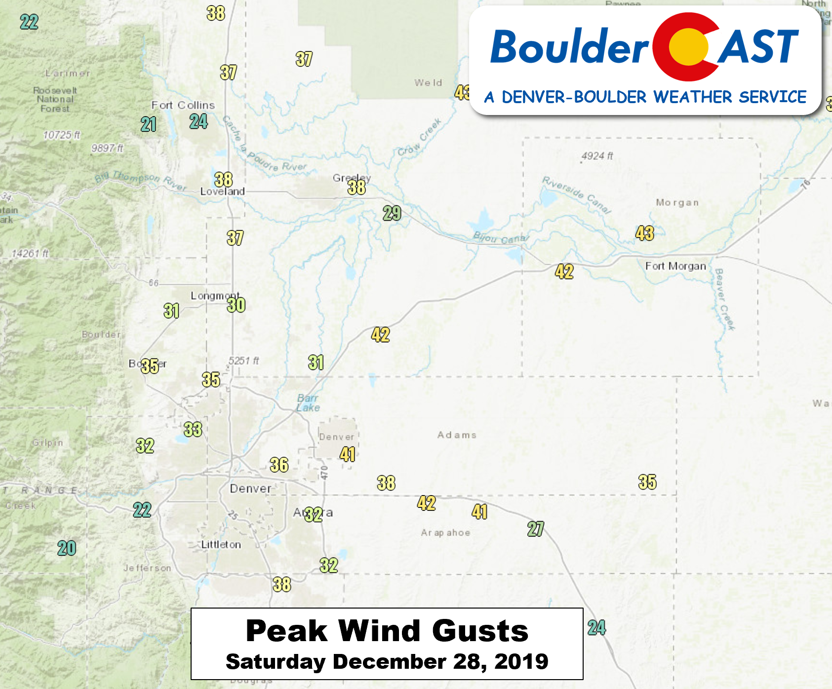
Outside of the wind, the final distribution of snowfall was not as expected either. While our forecast ultimately turned out very well in the Denver Metro area, snow in nearby regions boomed (southeast Wyoming) and busted (the Plains of northeast Colorado), deviating substantially from predicted snowfall amounts. 8-12″ of snow was reported east of Cheyenne. Cities like Fort Morgan, Akron, and Sterling got ghosted with less than 1″ of snow in many cases.
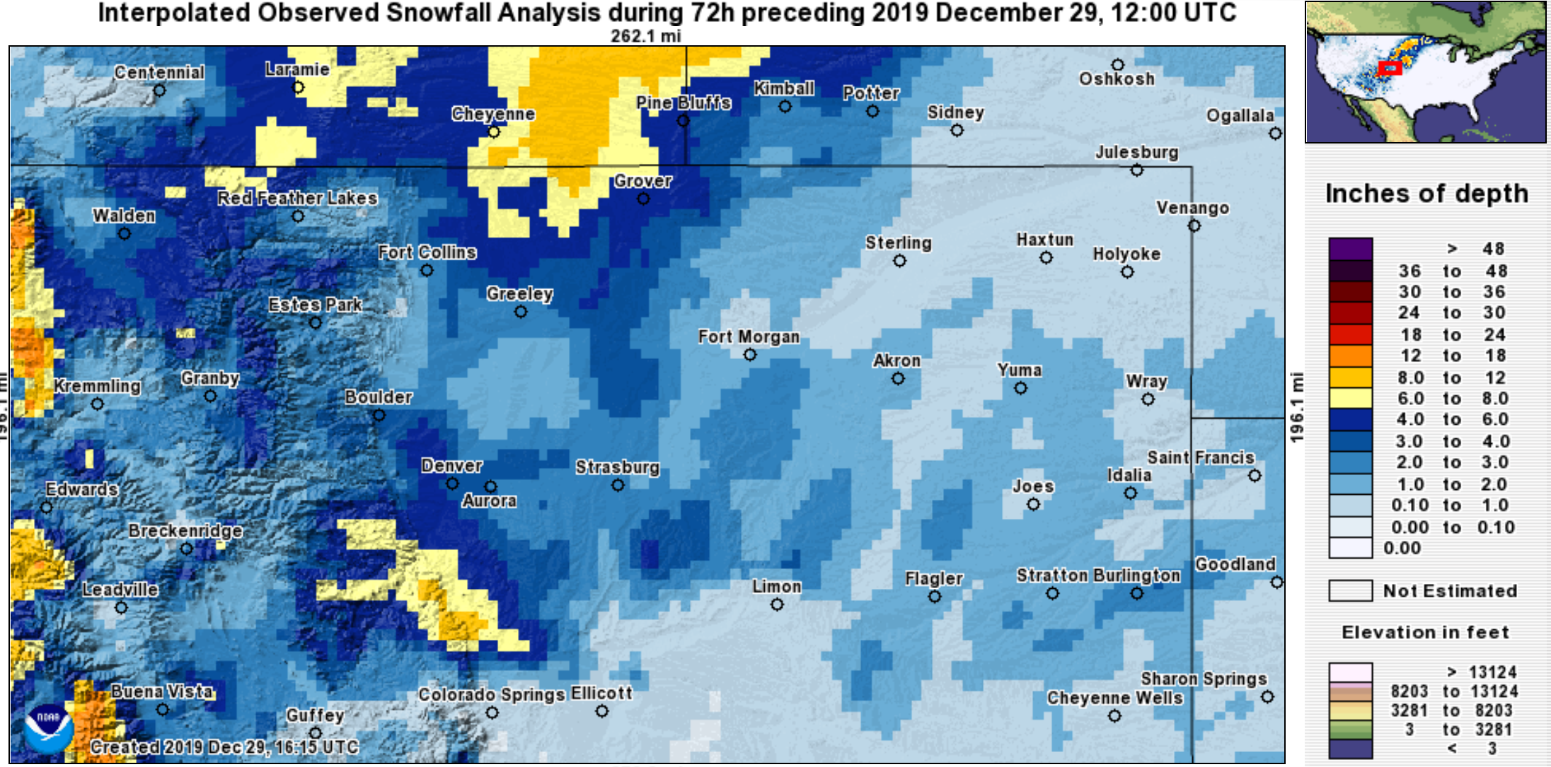
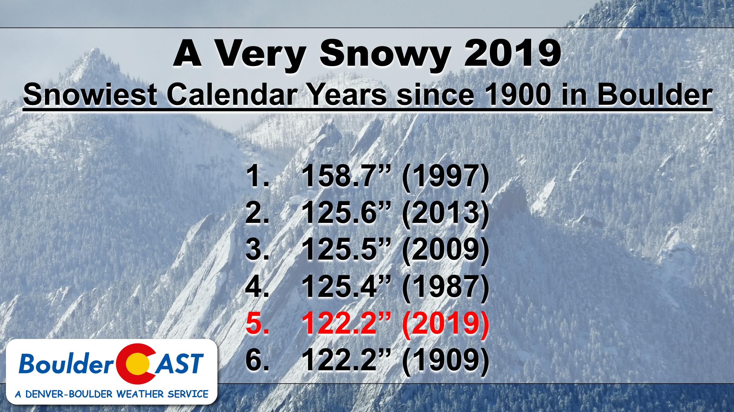
As you will see in our weekly outlook soon to follow, we’re done with snow for 2019 as the year concludes on a dry note. Thanks primarily to a very snowy October and November, 2019 will go down as one of Boulder’s snowiest calendar years….the 5th snowiest in fact with more than 122″ having accumulated.
Chilly today, but warming into the New Year
To start the week, the 30th of December, high temperatures will top out in the middle to upper 30’s. This comes after bitter cold morning temperatures in the lower teens. However, don’t be fooled as warmth will return to close out 2019 and ring in 2020! Currently, we are sitting rather well-off under weak high pressure. The big trough of low pressure that brought the snow this past weekend is heading east and away from us into the Great Lakes. With a similar airmass today to Sunday, highs in the 30’s are expected again this afternoon.

A nice warming trend is headed our way, commencing tomorrow and reaching its peak on Wednesday. Shown above are the near surface temperatures for midweek. A lee trough signature is evident from the Dakotas southward into Texas and New Mexico. As a result, a nice warm-up should push our highs Tuesday back into the 40’s and eventually the lower 50’s on Wednesday with lots of sunshine each day.
Colder after New Year’s Day; snowfall for the higher terrain
As we progress from Wednesday afternoon into the evening and night, a cold front and attendant gusty winds and moisture will plow through the region from northwest to southeast. The trough is expected to have its main center across Montana (below), but extend its cold reach from the Upper Midwest into New Mexico.

Accompanying this trough of low pressure will be a Pacific push of moisture tied to the upper-level jet stream (see below). A jet streak from the Pacific Northwest into Utah (below) will be positioned northwest to southeast, enhancing upslope flow over the higher terrain in west and northwest Colorado. This jet will have plenty of embedded moisture.

The moist northwest flow will actually persist from Wednesday through Friday, making for some great snow conditions in Steamboat and along and west of the Divide. Skiers will surely be happy to start 2020! The best days for fresh pow will be Wednesday, Thursday and Friday, so take your pick!
The below sea-level pressure pattern for mid-day Wednesday shows this atmospheric feature perfectly. Note the snow over west and northwest Colorado resulting from the upslope conditions. Further east, downslope over Boulder and the Front Range dry out the airmass producing warm and calm conditions. In the Denver Metro area, we certainly can’t rule out a chance of snow Wednesday night into Thursday morning with the frontal passage, but flakes will be minimal with just a dusting or less possible.

The mountains, however, will see a plethora of snowfall thanks to that persistent northwest flow. By Saturday morning (above), between 0.5 and 2 inches of liquid is poised to accumulate, enough for 1 to 2 feet of snow over the higher terrain. We think Steamboat and Winter Park stand to see the most out of this pattern.
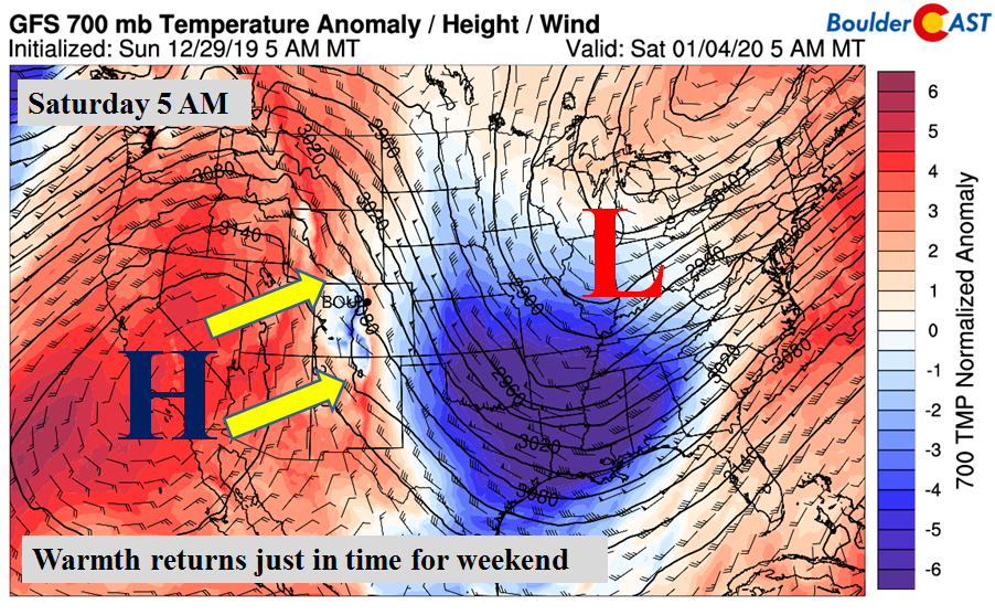
As we mentioned, the colder air will be making its way back into the area by Thursday, January 2nd. Windy conditions will be present Wednesday night/Thursday, and possibly again on Friday thanks to a tight pressure gradient and gusty northwest winds aloft in that jet. You’ll notice the well below freezing air at the 700 mb level (~5,000 feet up from us) Thursday morning in the below image. This should entrench much of the state to close out the week with highs back into the 30’s and lower 40’s.

All in all, certainty not a bad week by late December or early January standards. We more or less see a slight roller-coaster ride in temperatures. Cold to start, turning warm, then cooler again. Our precipitation chances are meager at best. The upcoming weekend also keeps flow in temperatures going. A quick glance at the extended outlook shows high pressure over southern California (below) building back eastward by Saturday/Sunday. Temperatures could certainly push back into the 50’s over the weekend!
.
Forecast Specifics:
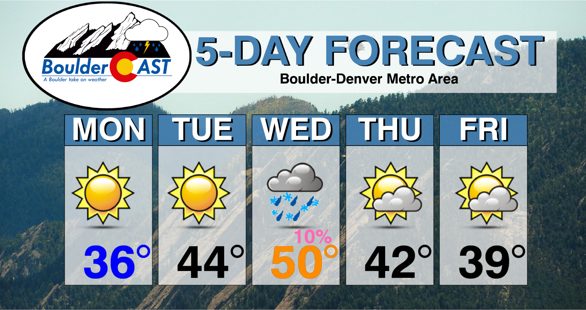
Monday: Sunny and chilly. Highs in the mid to upper 30’s for the Plains and middle 20’s in the Foothills.
Tuesday: Sunny and warmer. Lower 40’s for the Plains and lower 30’s in the Foothills.
Wednesday: Increasing mid and high-level clouds with gusty winds through the day in excess of 30 mph. A slight chance of rain/snow showers are possible late in the day and overnight with no accumulation expected. Highs in the low 50’s for the Plains and near 40 for the Foothills.
Thursday: Partly to mostly cloudy with a slight chance of snow showers/flurries in the early morning. Highs in the lower 40’s for the Plains and lower 30’s for the Foothills.
Friday: Partly cloudy, breezy, and chilly. Highs in the upper 30’s to lower 40’s for the Plains and upper 20’s in the Foothills.
High Country: After a quiet week over the higher terrain, a more active pattern takes shape from Wednesday into Saturday. A persistent northwest flow during this time will make for periods of moderate to heavy snowfall. Total snow amounts of 1 to 3 feet are possible, especially in favored areas of northwest Colorado. Check our PowderCAST page for always-updated weather forecasts for all of Colorado ski resorts.
LIMITED TIME OFFER: Use the promo code HAPPYHOLIDAYS to save 33% on BoulderCAST Premium.
DISCLAIMER: This weekly outlook forecast is created Monday morning and covers the entire upcoming week. Accuracy will decrease as the week progresses as this post is NOT updated. To receive daily updated forecasts from our team, subscribe to BoulderCAST Premium.

.
Spread the word, share our forecast!


You must be logged in to post a comment.