
The first full week of May looks to be rather unsettled, as a series of upper-level low pressure systems advance through Colorado. The first pushes in from the southwest on Tue/Wed, while a more potent storm system comes in from the west, affecting the forecast for the latter half of the week, including the University of Colorado’s Commencement.
The past week has featured a rather wet weather pattern of afternoon scattered storm development across Boulder County, similar in nature to a monsoon-type pattern. However, the summer monsoon does not come into full swing until June. This week will feature a series of upper-level storm systems arriving from the west and southwest that will combine with low-level easterly flow and abundant moisture for a wet week of weather and may potentially impact the Commencement ceremony on Saturday, May 9th, which is set for 8:30am at Folsom Stadium.
Below shows the current surface analysis map as of Sunday afternoon, May 3rd. A cold front extends from western Wyoming, southeastward through southwestern Nebraska. This cold front to the north of Boulder County will be moving through the region tonight and will result in afternoon scattered storms this afternoon and evening before tapering off after midnight.

Surface analysis as of Sunday afternoon. A cold front was located north of Colorado across Wyoming.
Below shows the position of the surface frontal boundary at the 850 mb pressure level from the GFS model for Monday afternoon. Easterly upslope flow is evident in the map, as well as cooler temperatures behind the front. This sets the table for a cooler day to start the week compared with Saturday and Sunday, where highs reached into the 70’s.

GFS forecast for the afternoon Monday, May 4th at the 850 mb pressure level
This upslope flow combined with weak instability from daytime heating and weak upper level shortwaves from the southwest will produce afternoon scattered storm activity across the Foothills and Plains. The map below shows the 500 mb vorticity from the GFS model valid Monday morning. A weak shortwave is centered over southern California. Ahead of this system, embedded weak shortwaves are evident by the spotty large vorticity values over Colorado. This will fuel monsoon-type moisture and large-scale synoptic lift for storm development.
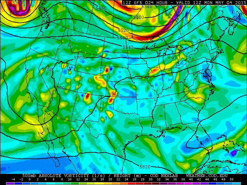
500 mb vorticity map valid for 6am Monday from the GFS model
It appears that our wettest day of the week will be Tuesday as the aforementioned weak low pressure area over Baja California moves into northern New Mexico and SE Colorado Tuesday afternoon and evening. This feature combined with plenty of moisture and the low-level easterly flow in place will lead to a rather wet Tuesday evening. The 500 mb vorticity for Tuesday from the GFS is shown below. The large vorticity values over southeastern Colorado will advect into Boulder County Tuesday evening for likely widespread rain and storms.
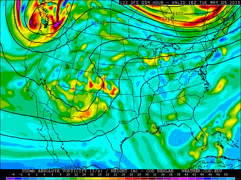
500 mb vorticity forecast valid for 12pm Tuesday from the GFS model.
The system on Tuesday is also carrying a large amount of moisture with it, some of it having tropical origins. The precipitable water is shown below from the GFS model. Values are between 0.9 and 1.0″ of precipitable water. The flow is also from the east and southeast, suggesting an abundant flow of moisture.
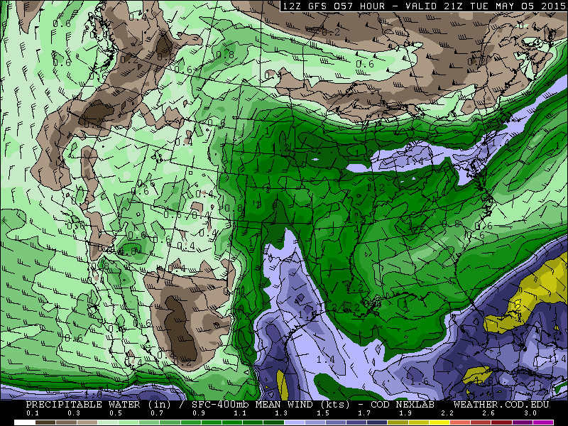
Precipitable Water for Tuesday afternoon from the GFS model
The latter part of the week will focus on a more potent upper level storm system. This system is currently in the northeastern Pacific Ocean, near the Gulf of Alaska, evident in the visible satellite image below. A large counterclockwise flow can be seen in the cloud cover, spiraling inward to low’s center. This system will move onshore Tuesday across the state of Washington, which can be seen in the previous 500 mb vorticity map.

Visible satellite image for Sunday morning. The large upper low is present over the Gulf of Alaska.
A lot of uncertainty surrounds the potential track and timing of this second storm system for late this week. Model forecasts last week could not agree on the timing and location of the storm, with the system being located over Wyoming, Nevada, and Colorado Friday and Saturday. Models were also not in agreement on timing, with some forecasts pushing the system through on Saturday, and others on Friday. As this post was written, the numerical weather prediction models have come in better agreement regarding the track and timing of the storm. It appears the prime time will be Friday and Saturday, right around commencement day for CU-Boulder. The ECMWF, GFS, and Canadian models agree fairly well that the upper-level system will cut-off from the main jet stream and dig southwestward toward southern California and southwestern Nevada by Friday. The system then appears to track northeast into western Colorado by early Saturday, exiting the state come Sunday the 10th. However, this track should not be considered the truth. We expect the models to flip-flop a little before the forecast becomes fine-tuned by Wednesday following the passage of the first storm system.
Below shows the position of the low evident in the 500 mb vorticity map for Saturday. The center of the low pressure is over central Utah, with southwesterly flow ahead of the trough and vorticity advection over eastern Colorado. This will produce large scale synoptic lift in the upper levels for storm development. Associated with this system will be a surface cold front, and an unstable airmass, bringing the potential for some severe weather.
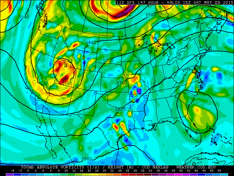
500 mb vorticity map, valid Saturday at 11am.
Forecast for Boulder County, the Foothills, and Mountains:
Boulder:
Monday: Highs cooler in the lower 60’s under partly sunny skies becoming cloudy with afternoon isolated/scattered storms across the city
Tuesday: Sunny early, followed by increasing clouds and isolated storms becoming widespread in the late afternoon/early evening and continuing into late evening, Highs to be in the middle 60’s
Wednesday: A drier day as southwest winds ensue for weak downslope flow, highs near 70. A few storms cannot be ruled out with an unstable airmass still in place
Thursday: Drier with only isolated storm activity around in the afternoon/early evening. Highs in the lower 70’s.
Friday: Partly to mostly cloudy skies with highs upper 50’s to low 60’s with increased storm activity by late afternoon
Saturday: Mostly cloudy with scattered storms possible and highs upper 50’s to low 60’s.
UNCERTAINTY: Friday and Saturday are the most uncertain at this point with the forecast, depending on the actual track of the secondary storm system. Be sure to check back on BoulderCAST.com for updated forecasts for commencement this Saturday.
Foothills:
Monday: High in the lower 50’s with afternoon scattered storms
Tuesday: Middle 50’s under partly cloudy skies becoming cloudy with widespread storm activity in mid to late afternoon continuing into the late evening
Wednesday: Highs upper 50’s to low 60’s with afternoon scattered storms
Thursday: Isolated storms with drier weather and highs in the lower 60’s
Friday: Lower 50’s with increasing storm activity by afternoon/early evening
Mountains:
The first storm system approaching Tuesday into Wednesday will be coming from the southwest. Because of this, it will be transporting warm air from the south into Colorado along with it. Given that, most of the storms in the mountains will be in the form of rain. Snow levels will be between 11 and 12,000 feet, so only the high mountain peaks will see snowfall. Some of these high peaks could see up to a foot of snow Tuesday into Wednesday. The second storm system will be coming from the north and and will be bringing down colder air from Canada. As a result, this will help to lower snow level to between 9 and 10,000 feet on Saturday. Expect scattered storm activity each day this coming week.


