
After a somewhat active holiday weekend in which Boulder recorded rainfall on two of the days, dry weather returns this week! With our next major storm system quite far out, this is the first “week ahead” post that comes to you 100% precipitation free. However, read on to find out about those temperatures!
Brace yourself for a stretch of typical September days across the Front Range, with dry conditions, warm afternoons, and cool nights. As of Tuesday morning, the trough that has kept our recent weather relatively active is centered over south central Canada (shown below). The trough axis has finally moved past Colorado, which will usher in drier, northwesterly flow aloft, effective immediately.
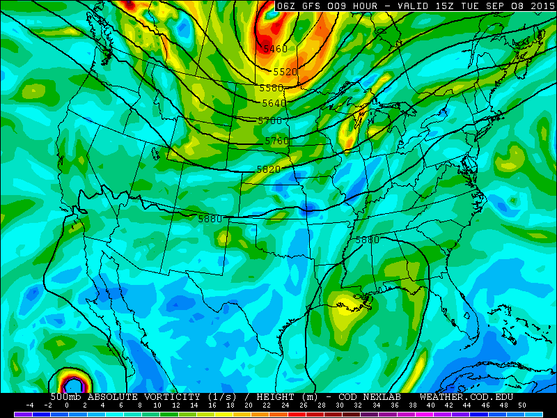
500 mb vorticity map from the GFS mode, valid at 9am Tuesday
This drier airmass is apparent below on the map depicting precipitable water (brown blob). Much of Colorado, including Boulder, has PW values under 0.4″ on Tuesday.
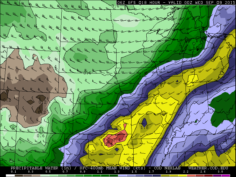
GFS model forecast for precipitable water (moisture), valid Tuesday evening
The pattern will remain largely unchanged through the week, characterized by low moisture, weak downslope flow, and minimal atmospheric forcing. In this position, lodged between a ridge to the west and a trough to the east, hot conditions will remain to our west, while the wet weather remains to our east. This will equate to plenty of sunshine, dry conditions, and seasonal temperatures. Wednesday’s 500 mb map is shown below. Not much change from Tuesday.
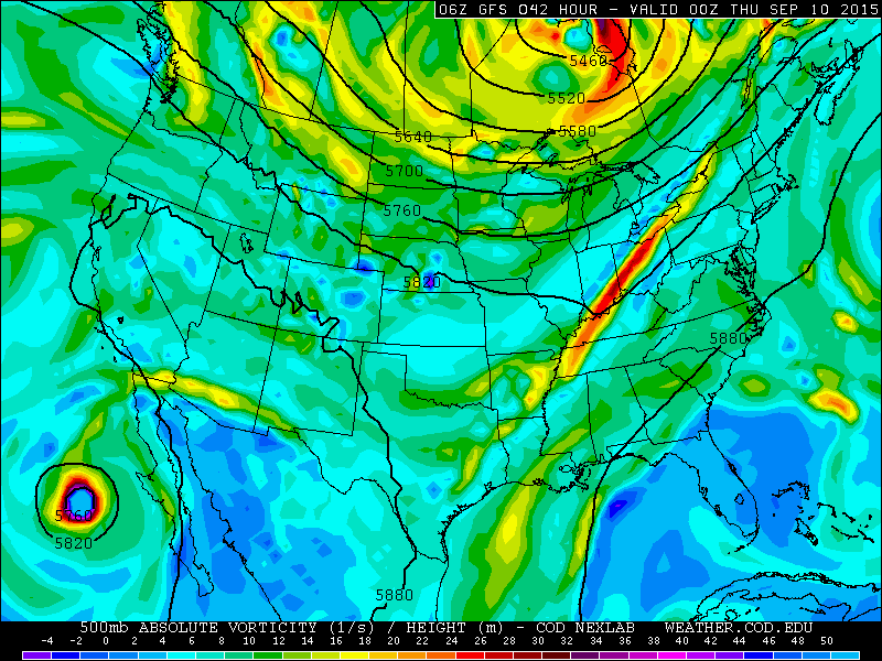
GFS 500 mb vorticity map, valid Wednesday evening
The one weather feature worth mentioning is a weak cold front that slides into eastern Colorado Thursday night into Friday morning. As the trough digs across the eastern United States, the cooler air will just briefly skirt eastern Colorado.
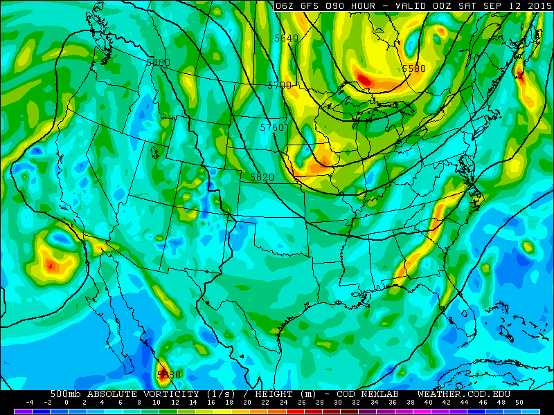
GFS 500 mb vorticity map, valid on Friday
This front will knock our temperatures down 5 to 10 degrees on Friday (mid 70s, compared to mid 80s on Thursday), and bring in a few more clouds. At this point, moisture is fairly limited, so we don’t expect precipitation. However, if some isolated showers do form, rest-assured they will be both brief and light.
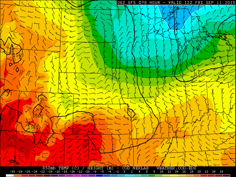
GFS 850 mb temperature map, valid Friday at 6am. The front, with cool northeasterly flow, has already invaded NE Colorado
Saturday will see temperatures rebound back into the 80s, and a continuation the beautiful stretch of weather.
With the week ahead laid out, let’s side track for a minute. You may have noticed Hurricane Linda in the 500 mb maps above, visible in the bottom left corners of the images. As we approach the peak of hurricane season (September 12th), we need to watch the Eastern Pacific Ocean closely for land-falling cyclones, whose remnants can eventually impact Colorado (i.e. September 2013 Boulder Flood). Fortunately, the current upper-level pattern is not favorable for landfalls. As such, Linda is projected to move northwest and die over open waters this weekend.
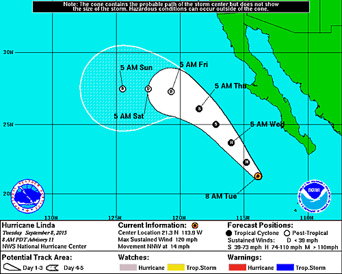
Hurricane Linda’s forecast track and intensity. The National Hurricane Center takes the storm away from land as it weakens.
The Forecast:
Tuesday: Mostly sunny with high temperatures in the low 80s on the Plains, low 70s in the Foothills.
Wednesday: Mostly sunny. Warmer with high temperatures in the mid 80s on the Plains, upper 70s in the Foothills.
Thursday: Mostly sunny and warm. Highs in the mid 80s on the Plains, with upper 70s in the Foothills.
Friday: A cold front moves through before sunrise. Cooler with partly cloudy skies. High temperatures in the mid 70s on the Plains and in the Foothills.
Saturday: Mostly sunny and warmer. Highs across the Plains in the low 80s, with 70s in the Foothills.
Source
Tue
Wed
Thu
Fri
Sat


BoulderCAST
82
86
86
77
82


NWS
83
85
84
78
82


AccuWeather
83
87
87
78
84


The Weather Channel
82
86
85
76
82
Last week’s recap:
Here are the results of last week’s forecast. First, the forecasts and observations:
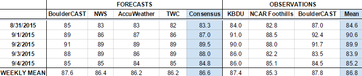
The consensus was for temperatures to remain at or slightly above normal through the week, with highs near 90 Tuesday through Thursday. Limited moisture and forcing were to bring the chance of rain each day through the week. BoulderCAST gave Monday and Friday the best chances for rain, with Wednesday being the driest day. In the end, precipitation was recorded in Boulder on Monday (0.01″), Tuesday (Trace), and Thursday (0.03″). The precipitation on Friday was spotty and remained mostly confined to the higher terrain.
Now the error analysis. Shown is the amount of degrees (in Fahrenheit) that each source was off from the mean observed temperature for Boulder. Positive values indicate the forecast was warmer than what actually occurred, while negative values arise from a forecast that was cooler than what was observed.
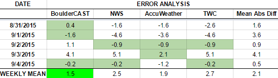
Monday, Wednesday, and Friday were forecasted quite well by everyone. Tuesday was actually the warmest day of the week, with all sources forecasting too cold this day. On Thursday, extensive cloud cover kept temperatures much cooler than anticipated. BoulderCAST had the best forecast Monday, Tuesday, and Friday!
The bottom row of the error table shows the weekly mean error for each weather outlet, a good measure for who was the best and more consistent “forecaster” for the week. Not surprisingly, the best overall forecast for last week goes to BoulderCAST (back on top!), with only 1.5 degrees of error averaged across the period. Check back next week to see if BoulderCAST can repeat victory!
—
If you haven’t already done so, follow us on Twitter or Facebook for frequent weather updates and subscribe to the site to get these posts automatically delivered to your email box (enter your email in the sidebar widget to right).


