Through October 18th, Boulder is sitting nearly 10 degrees above normal for the month of October. This week will aim to change that trend, with a drastic cool down and the return of precipitation to the region.
A large upper-level trough has just come ashore from the Pacific, and is currently centered over Nevada. This will be the biggest player in our weather this week…
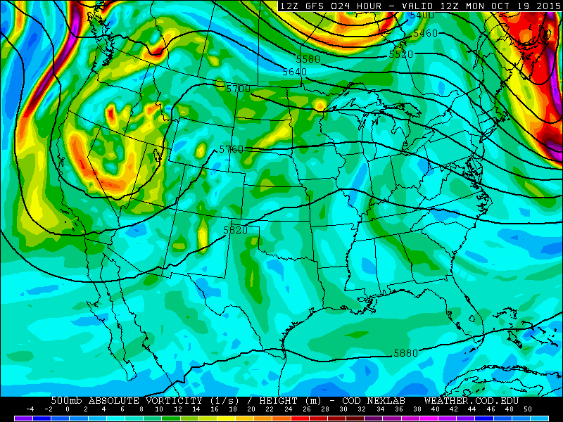
GFS 500 mb vorticity map, valid Monday morning, showing the position of a large trough to our west
On Monday, Colorado will just start to feel the effects of this trough. Southwesterly upper-level flow will advect in sub-tropical moisture, producing enough instability to fire off a few isolated to scattered thundershowers in the afternoon across mostly the higher terrain. The Plains will only have an isolated chance of a shower, and remain partly cloudy through the day. Any threat of showers will diminish after sunset. Southerly surface winds will keep us quite warm, with highs in the low to mid 70’s on the Plains.
By Tuesday, all models continue to show the trough dropping southward and splitting off from the main jet stream.

GFS 500 mb vorticity map, valid Tuesday at noon, showing the trough sagging south and cutting off from the jet stream
This will have two important impacts for Colorado:
- As a cut-off system, the upper-low will move much slower, prolonging the period of unsettled weather for our region
- The system will become isolated from the colder air, which will remain north in Montana. This will keep snow levels quite high through the duration of the event, likely at or above 10,000 feet
Tuesday will have a similar upper-level flow to Monday. Sunshine will dominate early, with clouds increasing through the day. With more clouds overhead, Tuesday will only reach into the upper 60’s. Scattered showers and a few storms will be possible from late Tuesday afternoon, into early Wednesday morning, alongside a cold front slated to move through the overnight hours into Wednesday. The best chance for precip during the day will be in the higher terrain, but the Plains won’t escape this round entirely.
Wednesday will see our prolonged period of above normal temperatures finally come crashing to an end, thanks to that potent pre-dawn cold front. Behind the front, the GFS is showing 700 mb winds east-southeasterly at 10-15 knots for much of Wednesday (see below), which is decent upslope. This will keep our area socked in with low clouds most of the day, with intermittent light showers and drizzle. Compared to Tuesday, temperatures will be some 15 to 20 degrees cooler on Wednesday, with highs in the upper 40’s.
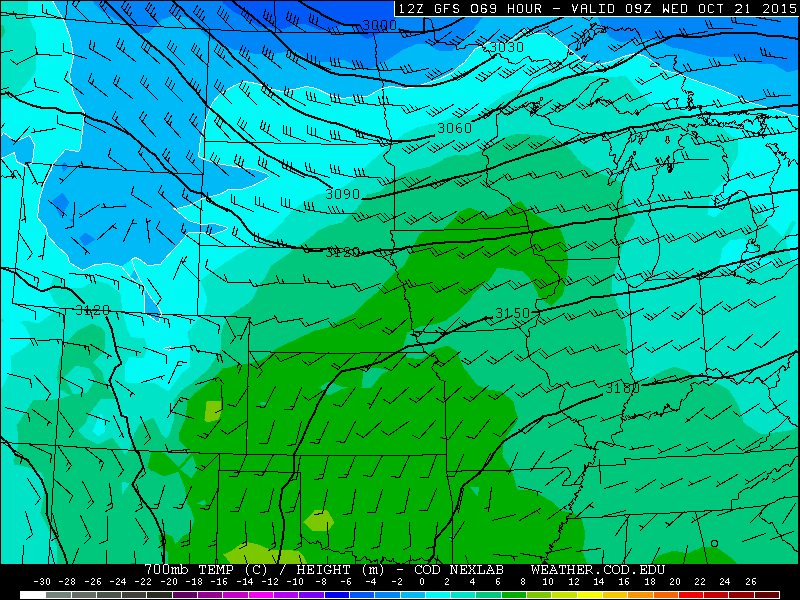
GFS 700 mb temperatures and winds, valid at 3am Wednesday. Easterly flow and colder air is invading NE Colorado
The best overlap between moisture, large-scale lift, and upslope will remain to our south, in southeast Colorado and New Mexico. We don’t expect any flooding for our area, but a widespread light to moderate precipitation event is likely, particularly in and near the Foothills. As mentioned before, snow levels will remain quite high for this storm, at their lowest, near 10,000 feet during the day Wednesday. East-facing slopes above timeberline will have a decent chance of picking up several inches Wednesday into Thursday, possibly enough to meet advisory criteria.
By Thursday, the trough axis draws ever-closer to Colorado, with the area of favorable lift moving through eastern Colorado during the morning (see below) as a surface low develops. This should bring another round of light precipitation to the region. Temperatures will not warm up much, maybe into the mid 50’s for the Plains, with mostly cloudy skies. There is model differences in how Thursday will play out. For now, expect at least the chance of rain to persist through the day. Late Thursday, mid-level flow becomes more westerly. With decent moisture available, orographic snows for the Divide are likely, with snow lingering into early Saturday. Nothing major at this point, but the potential exists for several inches.

GFS 500mb vorticity map, valid Thursday afternoon. The trough axis is over western Colorado, bringing a favorable region for precip to our region.
Friday will see things start to dry out as the trough pulls to our east. Skies will remain relatively cloudy, but some sun will return in patches during the afternoon. Another cold front moves into NE Colorado during the late-afternoon time frame. The timing of this front will be key to how warm we get on Friday. Low 60’s are a good bet at this point.
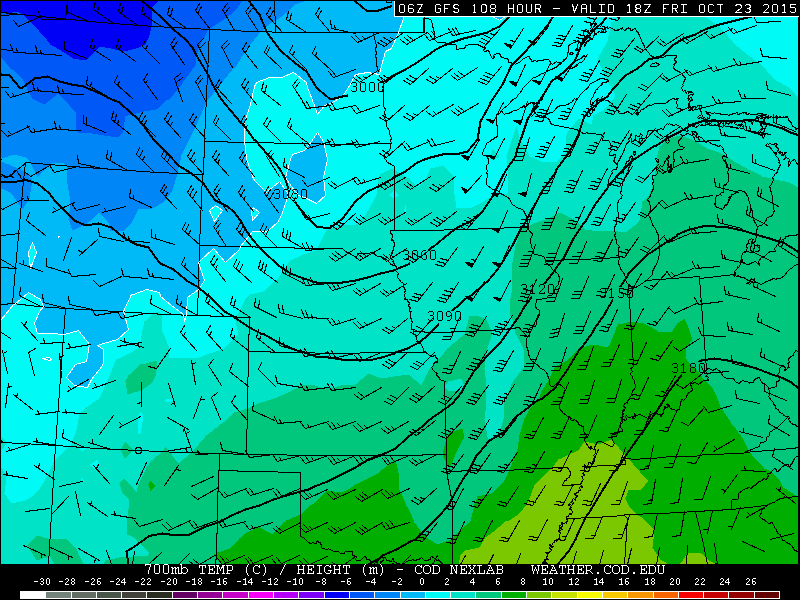
GFS 700 mb temperatures and winds, valid at Noon Friday. It depicts the leading edge of a cold front moving in NE Colorado
Warm and dry weather is a thing of the past for now. We don’t expect this week to be a complete wash-out, but Wednesday and Thursday look quite gloomy. Ensemble guidance shows that we can expect between 0.5″ and 1.5″ of precipitation through the week across most of Boulder County (with the higher amounts in and near the Foothills).

The Forecast:
Monday: Mostly cloudy and mild. Isolated showers and a few storms possible, mostly in the higher terrain. Highs in the low 70’s on the Plains, with upper 60’s in the Foothills.
Tuesday: Sun early, then increasing clouds, and mild temperatures. Isolated to scattered showers possible in the afternoon through the evening. Highs in the upper 60’s across the Plains, with low 60’s in the Foothills.
Wednesday: Low clouds with intermittent drizzle and light showers. Much cooler, with temperatures only reaching near 50 across the Plains, with mid 40’s in the Foothills.
Thursday: Mostly cloudy with a chance of showers, particularly in the morning. Highs in the mid 50’s across the Plains, with upper 40’s in the Foothills.
Friday: Mostly cloudy with isolated morning showers. Some peaks of sunshine in the afternoon are possible. Temperatures across the Plains in the upper 50’s, with mid 50’s in the Foothills.
High Country Forecast:
Isolated to scattered showers and storms on Monday and Tuesday. Snow showers possible Wednesday and Thursday above 10,000 feet east of the Divide, with several inches of accumulation possible. Friday morning, the focus for snow will shift to those slopes favored by northwesterly flow, tapering off by Saturday afternoon. Several inches are possible above timberline in the favored areas.
Extended Outlook:
After this week’s unsettled weather, we will be drier and milder through the beginning of next week under zonal or slightly ridging flow. This should keep temperatures seasonal.
Source
Mon
Tue
Wed
Thu
Fri


BoulderCAST
71
70
49
56
60


NWS
72
68
50
58
62


AccuWeather
73
70
50
55
60


The Weather Channel
70
70
50
58
61
Last week’s recap:
Here are the results of last week’s forecast. First, the forecasts and observations:
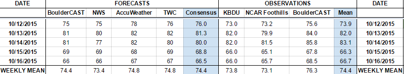
Last week began with much above normal temperatures, but cooled down with the passage of a cold front on Thursday. BoulderCAST had no mention of precipitation any day, and indeed, no precipitation was recorded. In fact, most days were cloudless (save a few cirrus).
Now the error analysis. Shown is the amount of degrees (in Fahrenheit) that each source was off from the mean observed temperature for Boulder. Positive values indicate the forecast was warmer than what actually occurred, while negative values arise from a forecast that was cooler than what was observed.
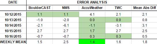
All days during the week had 3 degrees or less of mean error. Not bad for October. The cold front on Thursday was predicted quite well, with an average forecast error of 2.5 degrees (too warm).
The bottom row of the error table shows the weekly mean error for each weather outlet, a good measure for who was the best and more consistent “forecaster” for the week. Coming in number one this week is AccuWeather, with 1.4 degrees of error. BoulderCAST came in second place, with 1.6 degrees of error, despite only technically having the best forecast one day during the period. The NWS by far had the worst week, mostly due to their forecast on Tuesday, which clearly originated from left field.
—
If you haven’t already done so, follow us on Twitter or Facebook for frequent weather updates and subscribe to the site to get these posts automatically delivered to your email box (enter your email in the sidebar widget to right).


