
Following a warm weekend, with highs in the mid to upper 80’s across the Plains, this week will feature slightly cooler but still above average temperatures for the middle of October. A series of cold fronts will be the main storyline, along with the subsequent effect they will have on high temperatures. Our chance of rain is next to nil and hence it will be great weather for outdoor activities all around. Read on to find out just how warm it will get!
After a windy and warm Sunday across northeastern Colorado, where even a few Red Flag warnings were in place across far northeastern portion of the state, we are cooler today behind a cold front that pushed through last night. Before we go into this Monday’s forecast and the week ahead, we will show a few images to highlight this past Sunday’s weather.
Below shows the surface weather observations over Colorado yesterday. Highs were in the mid 80’s across the Front Range, with some locations in far northeast Colorado in the low to middle 90’s. These warm temperatures combined with the strong winds from the west-northwest to produce high fire danger in some areas. Two small brush fires ignited in the warning area east and north of Denver, one charring at least 100 acres. We have warned in the past that only a little bit of wind would produce fire weather conditions.
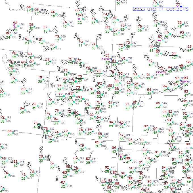
Colorado weather observations on Sunday, October 11, 2015
Below shows the visible satellite image from yesterday late in the afternoon. Colorado is located in the left part of the image. Notice the large band of clouds stretching from northeastern Colorado, up north into the Dakotas. This was the frontal system discussed earlier which will is responsible for today’s cool down. Sometimes you can pick up the front relatively easily due to clouds ahead of the system. However, that is not always the case in Colorado, where shallow, slow-moving, moisture-starved fronts are commonplace.
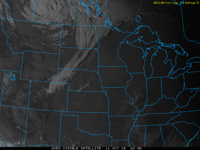
Visible satellite image late Sunday, October 11, 2015
In the end, the “heat wave” was not quite record breaking, at least in Boulder. The official high on both Saturday and Sunday was 86 degrees, with the record values sitting at 88 and 87 degrees, respectively. Areas in and near the Foothills got a brief windstorm Sunday evening, as the approaching cold front tightened the local pressure gradient. Gusts in the 35 to 55 mph range were common, with the highest gust measured at the NCAR Mesa Lab in southwest Boulder (73 mph).
For today, expect high temperatures some 10 degrees cooler than Sunday in the mid 70’s with upper 60’s in the Foothills of Boulder County with full sunshine. Below shows the 500 mb height pattern and absolute vorticity for Monday across the U.S. The aforementioned cold front yesterday was tied to a deep low pressure system now over Minnesota. Although not impacting us this week, off the coast of California is a cut-off low pressure system. This low actually impacted us on October 5th and 6th, and has since retrograded westward. It is possible this system could move northward by the weekend and possibly introduce precipitation to southwestern Colorado late Friday and Saturday. Don’t stress yet as there is a lot of uncertainty with the system that far out.
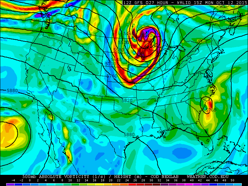
500 mb absolute vorticity forecast for Monday from the GFS model
On Tuesday and Wednesday, a large trough of lower pressure will be anchored across the eastern United States, as evident in the below 700 mb temperature and height pattern from the GFS model. In the western United States, where we live, you can see a general ridge of high pressure. However, this ridge will be centered more to our west over Arizona Tuesday and Wednesday, and hence, temperatures will be warmer but not as warm as we saw this past weekend (thanks to the trough to the north keeping the ridge at bay!). Expect highs in the low 80’s on Tuesday.
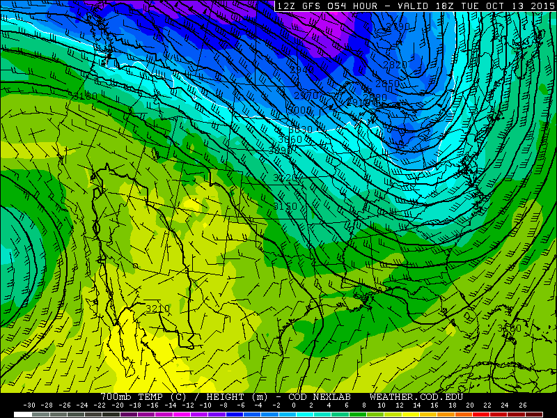
700 mb temperatures for Tuesday and Wednesday as forecasted by the GFS model
With the airmass on Wednesday similar to Tuesday, and 700 mb temperatures ~9 degrees Celsius over northeastern Colorado, expect high temperatures close to Tuesday, near 80 degrees. We should point out here that you can expect full sunshine most of this week, with the exception being Friday. As such, we are mainly discussing temperatures in this post.
Below shows the upper-level 250 mb winds at jet level and the height pattern. The trough in the eastern United States is quite evident in this image, with the jet stream just to the northeast of Colorado in the upper Midwest.
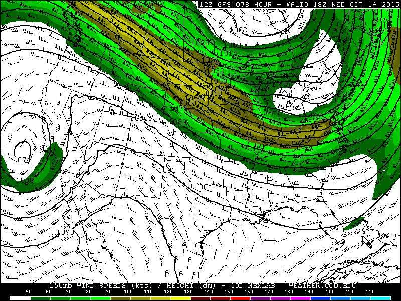
250 mb winds and height pattern for Wednesday as forecasted by the GFS model
As we go into Thursday and Friday, our attention will turn to another cold front pushing in from the north as the upper-level jet stream sags a little more southward, nudging the ridge further from Colorado. This will lead to another cool down late Thursday, but mainly on Friday. There are a few differences in the numerical weather models regarding the strength of the cold front and its impact on high temperatures for Friday.
The ECMWF (aka “The Euro”) developed at the European forecast center, is showing a stronger cold front with more cold air advection. The GFS, on the other hand, is weaker. These differences can be seen in the below two figures. On the right is the ECMWF forecast for Friday, while the left figures shows the forecast for the same time from the GFS model. Although Boulder is above the 850 mb pressure level with an elevation over 5,000 ft, this level is still useful for forecasting the airmass for Friday. As you can see, the ECMWF shows 850 mb temperatures between 6 and 8 degrees Celsius, while the GFS hints at 8-10 Celsius. The difference between the two models is likely related to the position of the upper-level jet stream. The actual strength of the cold front should be better forecasted by the models as we go into Tuesday and Wednesday. However, forecast guidance has trended toward a cooler day on Friday. So for now, well trend cooler, with highs possibly in the mid 60’s. These highs could be even cooler in the ECMWF model verifies.
With that being said, on Thursday, expect highs near 70 degrees from the Foothills to the Plains. A cold front is expected to move through by mid to late afternoon with northeasterly winds taking over. Boulder will likely see early-morning cloud cover Friday behind the cold front, but sunshine should win out by late morning for a cool and beautiful end to the week.
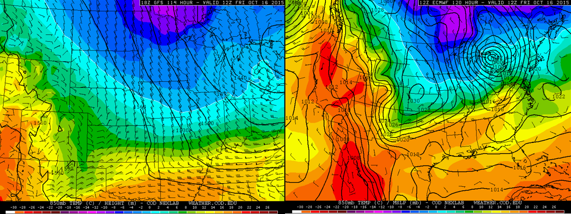
GFS 850mb temperatures and heights for Friday morning (LEFT). Euro 850mb temps and sea-level pressure for the same time (RIGHT)
The Forecast:
Monday: Mostly sunny, brisk and cooler, with highs in the mid 70’s on the Plains with upper 60’s in the Foothills. Northeast winds at 10-15 mph in the morning becoming light and variable in the afternoon.
Tuesday: Sunny and mild with temperatures above average in the low 80’s on the Plains, with mid 70’s in the Foothills. Winds will be variable at 5-10 mph.
Wednesday: Lots of sunshine, near 80 degrees on the Plains, with mid 70’s in the Foothills.
Thursday: Sunny skies, mild early, then turning slightly cooler later in the day as a front passes. High near 70 on the Plains and Foothills. Light winds becoming northeast at 10-15 mph.
Friday: Some clouds around in the morning, then sunny skies. Temperatures chillier with mid to upper 60’s on the Plains and low 60’s in the Foothills.
High Country Forecast:
We don’t have great news for the skiers. Expect tranquil and mild weather in the high-country most of the week. Although it will likely be windy with the upper-level jet stream close by much of the week, with gusts approaching the 30-50 mph range from the west and northwest. Expect increasing clouds late in the week Friday with a chance of rain/snow showers over southwestern Colorado.
Extended Outlook:
Our next chance of rain doesn’t enter the picture until Sunday or Monday. That will be a discussion for next week’s post, however, as uncertainty is too high at this point.
Source
Mon
Tue
Wed
Thu
Fri


BoulderCAST
75
81
81
69
66


NWS
75
80
77
69
66


AccuWeather
78
82
82
68
67


The Weather Channel
76
82
80
69
67
Last week’s recap:
Here are the results of last week’s forecast. First, the forecasts and observations:
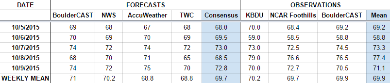
The consensus was for seasonal to above average temperatures through the week. We forecasted rain Monday through Wednesday, with a near certainty for rain occurring Tuesday evening. This forecast verified well, as Boulder received 0.09″ of rain Tuesday evening and a trace on Monday, with nothing recorded the other days.
Now the error analysis. Shown is the amount of degrees (in Fahrenheit) that each source was off from the mean observed temperature for Boulder. Positive values indicate the forecast was warmer than what actually occurred, while negative values arise from a forecast that was cooler than what was observed.
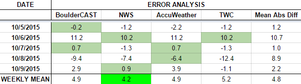
Two days stand out as very poor forecast days! On Tuesday, persistent low clouds and light rain showers kept highs cooler than forecast (59 degrees, instead of the forecasted 70). On Thursday, a cold front which initially was slated to push into Boulder County early in the morning, didn’t arrive until early evening. This allowed temperatures to warm much more than anticipated. At the time we made the forecast, this was four days out, so errors in such things as the position of a front are expected.
The bottom row of the error table shows the weekly mean error for each weather outlet, a good measure for who was the best and more consistent “forecaster” for the week. First place this period goes to the NWS, with a rather large 4.2 degrees of error averaged across the period. BoulderCAST came in second place, with 4.9 degrees of error, having the best forecast on Monday and Wednesday. Overall, this was by far the worst forecasting week for everyone. Hopefully we can nail down the forecast for the week ahead a little better!
—
If you haven’t already done so, follow us on Twitter or Facebook for frequent weather updates and subscribe to the site to get these posts automatically delivered to your email box (enter your email in the sidebar widget to right).


