After near record warm conditions thus far this fall, things are finally starting to feel like winter. Yesterday saw temperatures dip into the low 20’s during the morning hours (the coldest so far). Brrr! We also had our first snow of the season last Wednesday night. Way to go Boulder! Were you awake between midnight and 3am to see a few wet flakes mixing in with the rain? Looking to the week ahead, a powerful storm system will develop just to our southeast, bringing the likelihood of snow once again to the Front Range. Read on for all the wintry details!
UPDATE (Posted Tuesday November 10 at 11am MT): Forecast snow totals and timing
We have to go back in time to 2004 to find a year with a later first snowfall. Let’s hope the continuing El Niño conditions can help turn the odds in our favor. We can definitely use the snowpack!
As we mentioned, there is a strong possibility of a potent low pressure to bring a quick shot of snow to the region Tuesday night. The models are in extremely good agreement of this. Truly, almost too good of agreement.
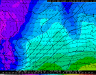
First, let’s look at the current weather set-up. Shown below is the 500mb pattern for Monday morning. The weather system to watch, currently over the Pacific Northwest, is denoted with a red “X.”
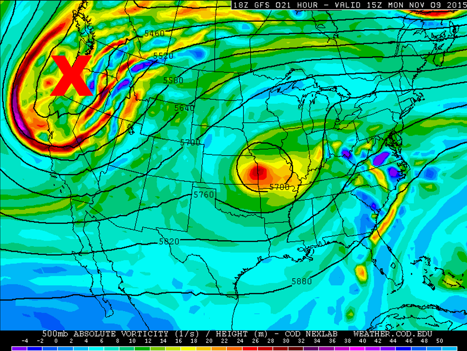
GFS 500 mb vorticity map, valid at 8am Monday. This week’s main weather player is denoted with a red “X.”
Ahead of it’s arrival, Colorado will be under the influence of a southwesterly flow aloft on Monday. There is not much forcing, and with the downslope flow, we expect no precipitation and a relatively sunny day across the region. Temperatures will be slightly above normal, in the low 60’s for the Plains.
As the trough approaches on Tuesday, the flow begins to moisten. It should be another warm-ish afternoon, but increased mid/high-level clouds may keep us a little cooler than Monday (only the mid to upper 50’s). Tuesday evening. things start to get dicey.
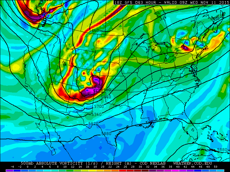
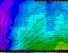
GFS 500mb vorticity map, valid at 2am Wednesday morning.
The trough zooms across the Rockies and explodes as it reaches the Plains, developing a deep, closed-low over eastern Colorado. This is driven by intense jet streak at the base of the trough (shown below), with maximum speeds exceeding 165 mph. Colorado is conveniently in the left exit region, a location that is favorable for upper-level divergence, lift, and therefore, storm development.
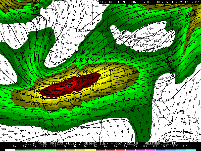
GFS 250 mb height and wind map, valid at 5pm Tuesday evening. A powerful jet streak approaches Colorado, acting as the driving force to develop the strong system in Colorado.
The 700 mb map below shows plenty of cold air and strong upslope (below). Seriously, 30-45 mph northeast winds at 700 mb!
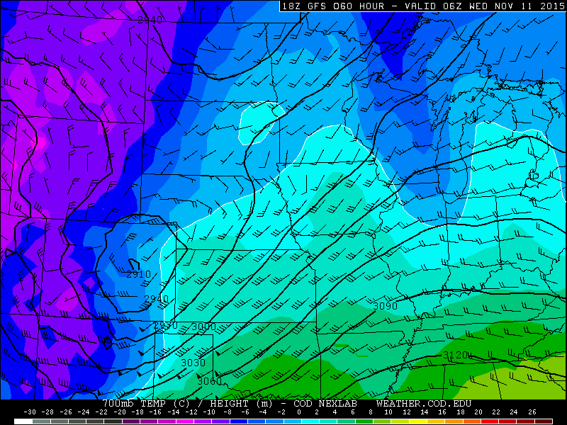
GFS 700mb temperature and wind map for Tuesday night at 11pm. Notice the closed-low over eastern Colorado, with 30+ mph NE-erly flow for Boulder County.
Low-level easterly flow will increase Tuesday afternoon, feeding in more moisture at the surface. See how nicely the moisture is wrapped into the system below, a depiction of the surface dew points and winds at 11pmTuesday night.
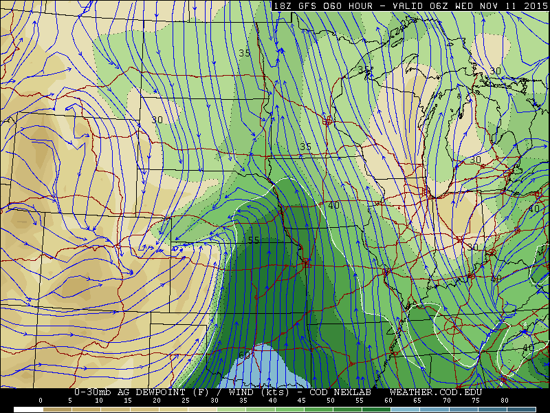
GFS surface dew point and streamlines, valid at 11pm Tuesday night. Notice the influx of moisture into the core of the system in eastern Colorado.
The cold air is scheduled to arrive into northern Colorado after sunset on Tuesday. There may be a short period of rain, but it should quickly change over to snow for everyone before midnight.
The cold air and dynamics are right on track to produce snow in Boulder County. However, the one factor that will significantly limit snowfall amounts is the sheer speed of the system. It zips across the state, only providing about an eight hour window for precipitation to occur. The system will already be trekking through Minnesota by Wednesday evening! The quick shift to northwesterly flow could keep snow totals down a bit, especially in locations near the Foothills.
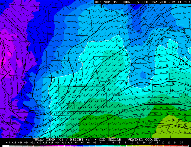
There is also slight uncertainty in where the low may develop. The GFS keeps it in east-central Colorado, while the NAM currently has it a bit further north, pushing a bulk of the snow into southern Wyoming. See the comparison 700 mb maps form the NAM and GFS below.
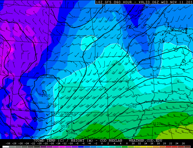 GFS 700mb (Tuesday night at midnight)
As quickly as the storm arrives, it will exit. Strong northwesterly flow will take over in the late morning hours Wednesday and continue into the evening. The precipitation should come to and end in the late morning, with skies starting to clear thereafter. Blowing and drifting snow could be a concern, particularly over the Mountains, Foothills, and the Plains northeast of Denver. With the sunshine, temperatures will warm up into the low 40’s.
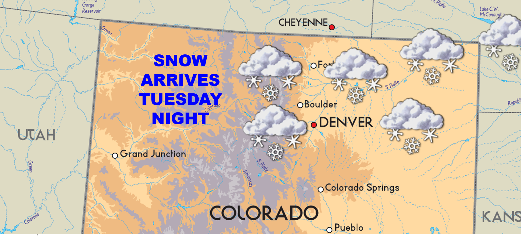
It is a bit early to make a definitive snowfall forecast. However, as of now, we expect less than 6″ for the Plains, with the possibility of a little more in the Foothills and Mountains. Right now we are hedging towards a 2 – 4″ event for the city. Stay tuned to BoulderCAST as we evaluate the situation and provide an update tomorrow afternoon.
Thursday and Friday will be rather docile across the state. Northwesterly flow will set up, with plenty of sunshine for Boulder. A weak cold front tied to the trough over the Midwest (see below) slides through Thursday afternoon/evening, providing a small shot of reinforcing cold air. As a result, we will remain cool, with temperatures in the mid to upper 40’s both days, and no precipitation to mention.

GFS 500 mb vorticity map, valid Thursday evening. Another trough will be impacting the Northern Plains.
The Forecast:
Monday: Mostly sunny skies and mild. Highs in the low 60’s across the Plains, with 50’s in the Foothills.
Tuesday: Some sun early, with clouds increasing through the day. Afternoon highs in the upper 50’s for the Plains with low 50’s in the Foothills. Rain developing after sunset, quickly changing to snow that will continue through the night.
Wednesday: Cloudy skies with snow showers ending mid to late morning. Windy conditions overnight and in the morning will produce areas of blowing snow. Clouds will clear somewhat through the afternoon. Temperatures warming into the low 40’s for the Plains, with 30’s in the Foothills.
Thursday: Partly to mostly sunny skies. Temperatures in the low to mid 40’s across the Plains, with upper 30’s in the Foothills.
Friday: Mostly sunny and seasonal. Highs in the upper 40’s for the Plains, low 40’s for the Foothills.
Source
Mon
Tue
Wed
Thu
Fri


BoulderCAST
61
57
42
43
49


NWS
60
51
40
42
48


AccuWeather
61
57
44
43
48


The Weather Channel
61
55
42
43
50
Last week’s recap:
Here are the results of last week’s forecast. First, the forecasts and observations from all of the sources:

We had a very warm start to the week (70’s), cooling down as the snow-producing cold front arrived on Wednesday evening (into the 40’s).
Let’s look at the error analysis. Shown below is the amount of degrees (in Fahrenheit) that each source was off from the mean observed temperature for Boulder. Positive values indicate the forecast was warmer than what actually occurred, while negative values arise from a forecast that was cooler than what was observed.
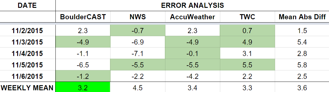
The worst forecast for the week ended up being Thursday, with nearly 6 degrees of error averaged across the board. Clouds dissipated rapidly, giving way to more sunshine that expected. This allowed temperatures to soar to 51 degrees (above the forecasted 45).
The bottom row of the error table shows the weekly mean error for each weather outlet, a good measure for who was the best and more consistent “forecaster” for the week. BoulderCAST just squeaked into first place, with 3.2 degrees of error, having the best forecast on both Tuesday and Friday. The NWS brings up the rear, with a particularly poor forecast on Wednesday.
Check back next week to see if we can beat out the competition once again!