
After nearly a week of below freezing temperatures, including a frigid and snowy Thanksgiving, the weather will make a turn for the better during the upcoming week with temperatures rising into the 50’s. Read on to find out when the warm-up arrives!
A large trough of low pressure was located across the Western United States last Wednesday. This same system is about to exit the region later tonight, after nearly a week of rotating across Nevada. The low is centered over southeastern Wyoming and northern Colorado. It will be pushing northeastward this afternoon and evening. With that, westerly flow will ensue, which will lead to deceasing clouds and sunshine taking over this afternoon with highs still below normal in the lower 30’s on the Plains.
GFS 500 mb Absolute Vorticity forecast this afternoon
Elsewhere, in the High-Country, as the system pushes eastward, west-northwest winds will be present west of the Continental Divide. This coupled with low-level moisture in place from the aforementioned storm system, will lead to scattered snow showers over the mountains. An additional 2-4 inches of snow can be expected from this afternoon into Tuesday morning. This will lead to decent conditions across several ski resorts along and north of I-70 west of the Divide. This is supported by the NAM model forecasted radar reflectivity for tonight, which shows a swath of snowfall across northwestern Colorado.

Forecasted radar reflectivity from the NAM for this evening
As we go into Monday evening, a wind event will ensue from midnight through the morning hours on Tuesday.
As the system pulls eastward, it will have one final influence on us: high winds! Below shows a two-panel plot of the forecasted sea-level pressure (left) and 700 mb level wind speeds (right). On the left, an area of high pressure is over western Colorado. A tight pressure gradient (evidenced by the tight blue pressure contours) is also present. This feature indicates westerly flow across Boulder County. The 700 mb winds show speeds as high as 45 mph. Expect gusty winds to commence just before midnight tonight, increasing overnight and into Tuesday morning. These winds could gust as high as 45 mph in Boulder and over 55 mph in the Foothills. The high winds will keep temperatures above freezing overnight with spotty areas of blowing snow.
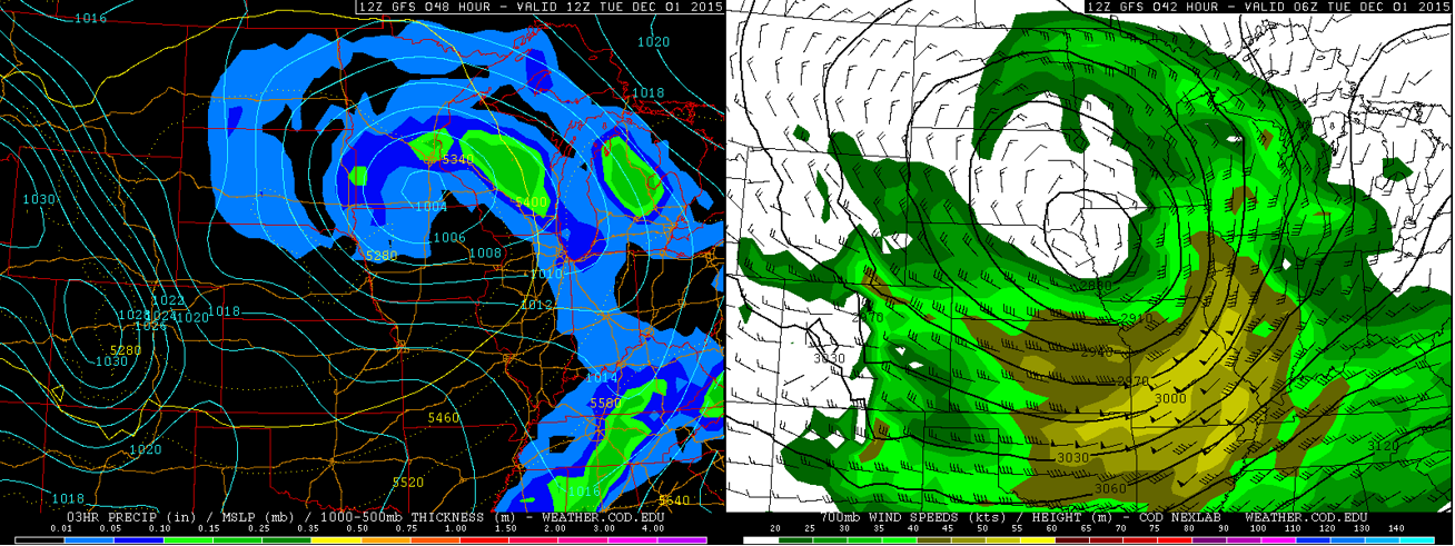
Sea-level pressure forecast (left) and 700mb wind forecast (right) from the GFS for Tuesday morning.
As we go into Tuesday, the storm is well off to our east over Iowa. However, as mentioned earlier, we will have those gusty winds from the west in the morning hours. These winds will decrease Tuesday afternoon as the pressure gradient relaxes. The downslope winds will help to warm us up into the lower 40’s on the Plains, even with the snow cover on the ground.
GFS 500 mb forecast for Tuesday
On Wednesday, a ridge of high pressure starts to build into Colorado from the west (see below). High upper-level heights start to build in from California, which is a good indicator of warmer temperatures and sunny conditions returning. Temperatures could be warmer, but with still a little snow on the ground, we will be in the middle 40’s.

GFS 500 mb forecast for Wednesday
This ridge of high pressure further builds and pushes east by Thursday, allowing temperatures to rise back into the 50’s, something we have not seen for about a week’s time! Expect mid 50’s on the Plains and mid 40’s in the Foothills.
On Friday, a weak trough will be pushing east from California into Arizona. This trough is quite weak in all forecast models, namely the GFS, ECMWF, and GFS Ensemble. Also, there is not much indication that this will have enough moisture to affect Colorado. It is likely the forecast may change, but right now we don’t expect any threat of precipitation for Friday. Temperatures will further warm to end the week, into the upper 50’s on the Plains.
GFS 500 mb forecast for Friday
The Forecast:
Monday: Mostly cloudy skies giving way to afternoon sunshine. Highs still below normal but above freezing in the low 30’s for the Plains and middle 20’s in the Foothills.
Monday Night: Light west winds becoming breezy by midnight, with sustained winds at 20-35 mph and gusts over 45 mph on the Plains. In the Foothills, west winds may gust over 50 mph. This will create areas of blowing snow.
Tuesday: Breezy, sunny, and warmer, with some blowing snow in the morning. West winds at 30 mph, with gusts over 45 mph and over 50 mph in the Foothills. Winds will decrease in the early afternoon. Highs in the lower 40’s for the Plains and middle 30’s in the Foothills.
Wednesday: Mostly sunny and pleasant. Highs warmer into the middle 40’s on the Plains and upper 30’s in the Foothills.
Thursday: Sunny skies and gorgeous. Expect high temperatures to rise to the mid 50’s for the Plains an mid 40’s in the Foothills.
Friday: Sunny skies again with beautiful weather to end the week! Highs in the upper 50’s for the Plains and low 50’s in the Foothills.
Source
Mon
Tue
Wed
Thu
Fri


BoulderCAST
33
42
47
52
57


NWS
32
41
48
52
54


AccuWeather
31
39
46
50
53


The Weather Channel
30
39
46
49
49
Last week’s recap:
Here are the results of last week’s forecast. First, the forecasts and observations from all of the sources:
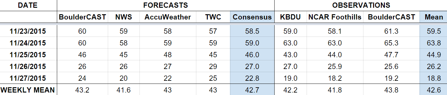
Last week began quite warm, but that changed rapidly with the passage of an Arctic cold front on the day before Thanksgiving. We expected 4-8″ of snow for Boulder by Friday afternoon (we officially got 7.1″). There was even a little bit of freezing drizzle to start the event.
Let’s look at the error analysis. Shown below is the amount of degrees (in Fahrenheit) that each source was off from the mean observed temperature for Boulder. Positive values indicate the forecast was warmer than what actually occurred, while negative values arise from a forecast that was cooler than what was observed.
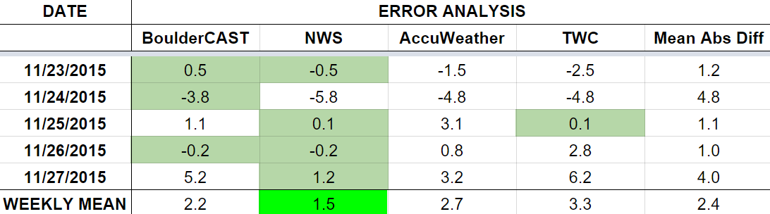
The worst forecast day of the week ended up being Tuesday, with nearly 5 degrees of error averaged across the board. The day before the Arctic air arrived warmed up more than most models were indicating (64 degrees, instead of the forecasted 59 degrees). Wednesday turned out remarkably well, considering the timing of the cold front was a bit uncertain. The last three days of the week were forecasted quite well, even with how much colder the air mass was behind the front. Friday had more sizable error (it was colder than forecast), but that was 5 days out from when the forecast was issued, so it is to be expected.
The bottom row of the error table shows the weekly mean error for each weather outlet, a good measure for who was the best and more consistent “forecaster” for the week. The National Weather Service takes first place this period, with just 1.5 degrees of error. BoulderCAST fell just short, and takes second place, having the best forecast on Monday, Tuesday, and Friday.


