After a very hot and dry stretch of weather across the Front Range for the last several days, we will be a tad cooler with the chance of rain returning by mid-week.

Temperature (red) and dew point (green) time series for Monday morning at BoulderCAST, showing the passage of a cold front just after 6:30am.
A cold front has moved through NE Colorado this morning, bringing gusty winds and increased low level moisture (see above). The BoulderCAST weather station recorded a 9-degree temperature drop and an 11-degree dew point rise in just over an hour immediately following the frontal passage this morning. In the upper levels, Colorado is still under the influence from a very warm and flat ridge. Despite the upslope and elevated moisture, the atmosphere will remain quite stable through Wednesday morning. This stability can be visualized by the formation of nighttime mountain wave clouds the last two evenings, apparent on the current visible satellite image shown below.

Colorado visible satellite image on Monday morning, depicting a wave cloud immediately downwind of the mountains over much of the state. You can even see the abundant, though rapidly declining, snowpack quite well.
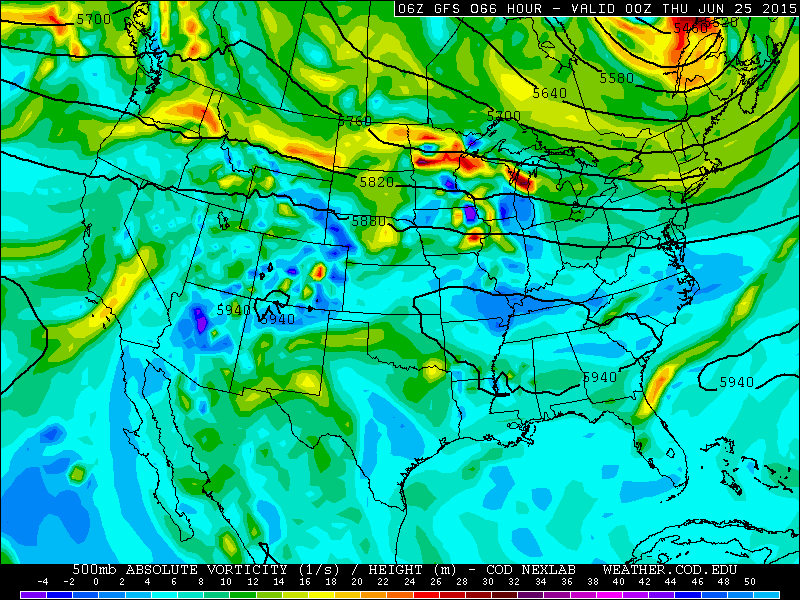
Abundant sunshine should still allow temperatures to climb to near 90 degrees on Monday, Tuesday, and Wednesday under the influence of the flattened ridge, shown below.

500mb height and vorticity forecast from the GFS model, valid Monday morning. Notice the flattened ridge over our region.
However, by Wednesday, our upper ridge will begin to break down, paving the way for a few afternoon thunderstorms to develop.
500mb height and vorticity forecast from the GFS model, valid Wednesday evening. Notice how the ridge over our region has weakened significantly (nearly disappeared!), compared to the previous map.
For the end of the week, a massive ridge aloft develops into the Pacific Northwest, with Colorado on the eastern fringes of its influence (see below). This pattern will be slightly cooler for us, as the warmest air will surge into Idaho, eastern Washington and eastern Oregon. Under this set up, temperatures will remain near or slightly above normal, with a chance of afternoon storms each day through the weekend. At this point, the best chance for significant storm coverage in Boulder County appears to be Friday afternoon, as a shortwave feature tracking along the edge of the ridge moves overhead. Fortunately, at this point, there doesn’t appear to be favorable conditions for any of the storms this week to turn severe.
Overall, this week should not be terribly wet. The GFS model keeps most locals in the Metro Area under 0.5″ of rain through Friday.
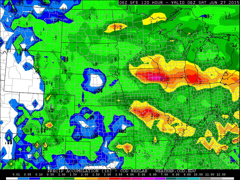
GFS model forecast precipitation totals through Friday night. Most of NE Colorado should see less than an inch. Boulder County is even forecast to have 0.25″ or less.
The Forecast
Monday: Mountain wave cloud dissipating by late morning, with sunny skies thereafter. Highs in the mid 80s on the Plains, mid 70s in the Foothills.
Tuesday: A few clouds early, giving way to mostly sunny conditions. A few extremely isolated storms may impact the higher elevations. Highs near 90 on the Plains, with low 80s in the Foothills.
Wednesday (Bike to Work Day): Overall, we have confidence that it should be a rather dry day for those planning to participate in Bike to Work Day! Take lots of water as it will be a hot one! The morning low temperature will be in the low 60s, perfect for biking. Mostly sunny with a few isolated afternoon high-base storms developing in and near the Foothills, with high temperatures in the low 90s on the Plains and low 80s in the Foothills.
Thursday: Party cloudy with isolated to scattered storms developing in the afternoon, first in the higher elevations, then moving eastward onto the Plains. A tad cooler with temperatures in the mid 80s on the Plains, 70s in the Foothills.
Friday: Party sunny with scattered to numerous storms developing after noon. This should be our best chance of rain during the week. Highs in the low 80s on the Plains, low 70s in the Foothills.
—
If you havent already done so, follow us Twitter or Facebook for frequent weather updates and subscribe to the site to get these posts automatically delivered to your email box (enter your email in the sidebar widget to right)!


