After a mild weekend, we return to winter starting this evening as an upper-level shortwave dives southeast bringing snowfall to Boulder, the adjacent Foothills, and Denver. After the snow moves out early Tuesday, temperatures moderate with sunshine and low 50’s to round out the week. How much snow is on tap? Read on to find out!
Cold and snow for Monday!
A return to winter and snow is in the forecast for Boulder and Denver this evening into tomorrow. Below shows the 500 mb absolute vorticity forecast from the GFS for this evening.
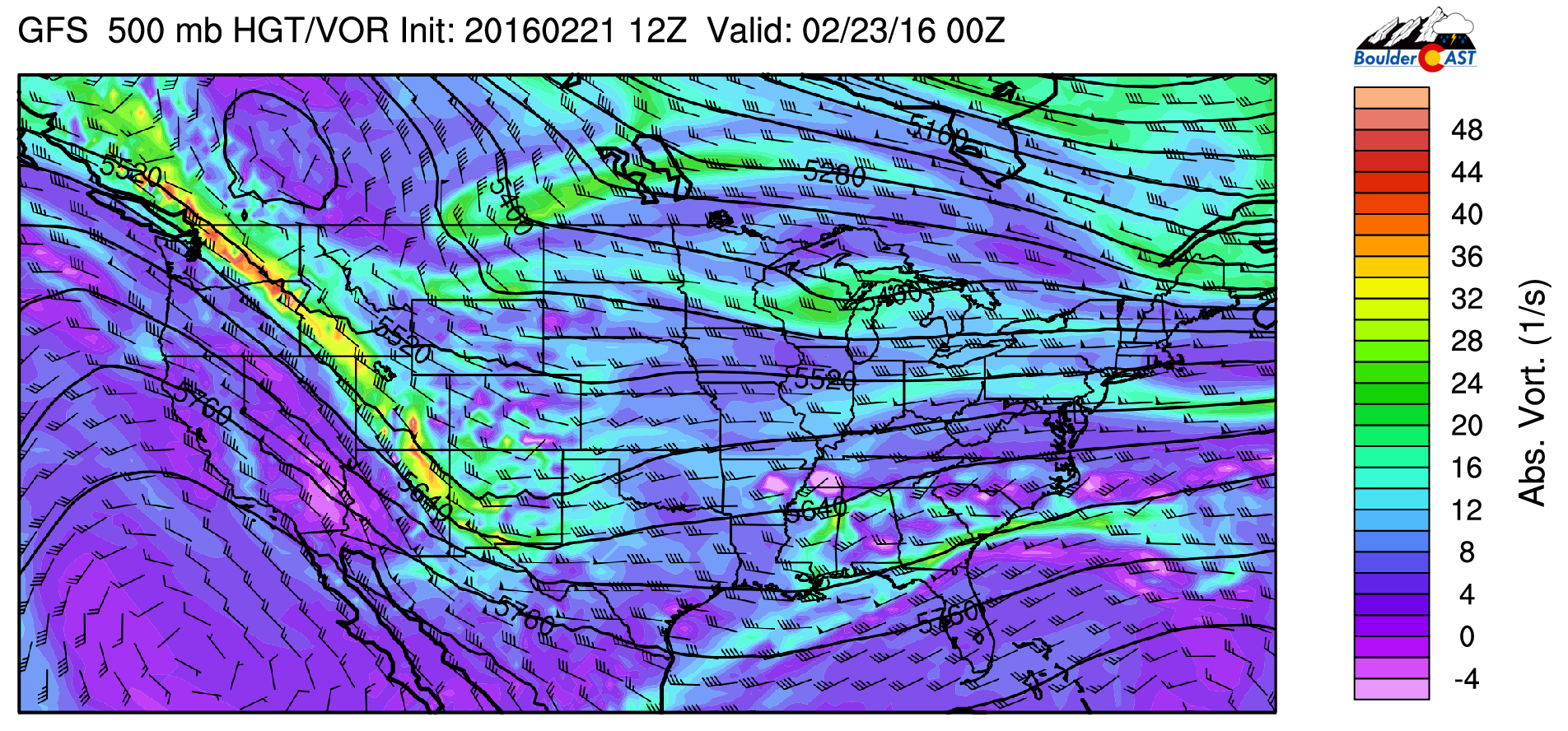
GFS 500 mb absolute vorticity for this evening
A shortwave stretches from Idaho into northeastern Arizona. This shortwave will dive southeast tonight into tomorrow morning. Notice how the wave is a bit west of our area. The main forcing for snow tonight will be shallow upslope accompanying a cold front moving down out of Wyoming, although the shortwave will certainly create upper-level divergence to enhance the lift.
Ahead of the snow, expect a mild day today near 50 degrees!
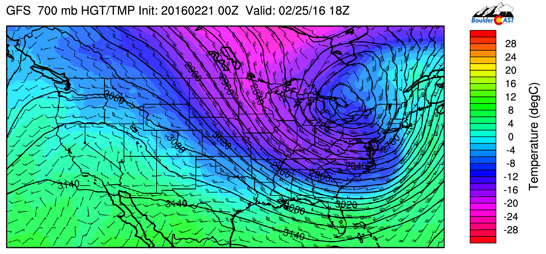
Below shows the 700 mb temperatures and winds for tonight from the GFS model. Temperatures are around -12 to -14 Celsius, which is perfect for dendritic snow growth. Northeasterly flow is also evident and will be the major player in producing lift our snow.
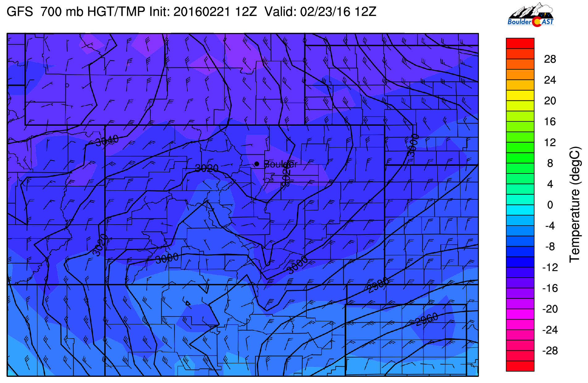
700 mb temperature and wind tonight from the GFS model
The precipitation looks to start this evening, right around rush hour, tapering off late Tuesday morning. It may initially start as light rain or sprinkles, but should quickly transition to snow by mid-evening. The warm ground from the prior week may limit snow accumulations during the onset of the event. For this reason, we expect tonight’s evening commute to be fine. Things will go downhill late tonight, however. Temperatures will fall into the 20’s overnight so accumulation will be likely on the roads, making for a slick Tuesday AM commute in spots, especially those closer to the Foothills.
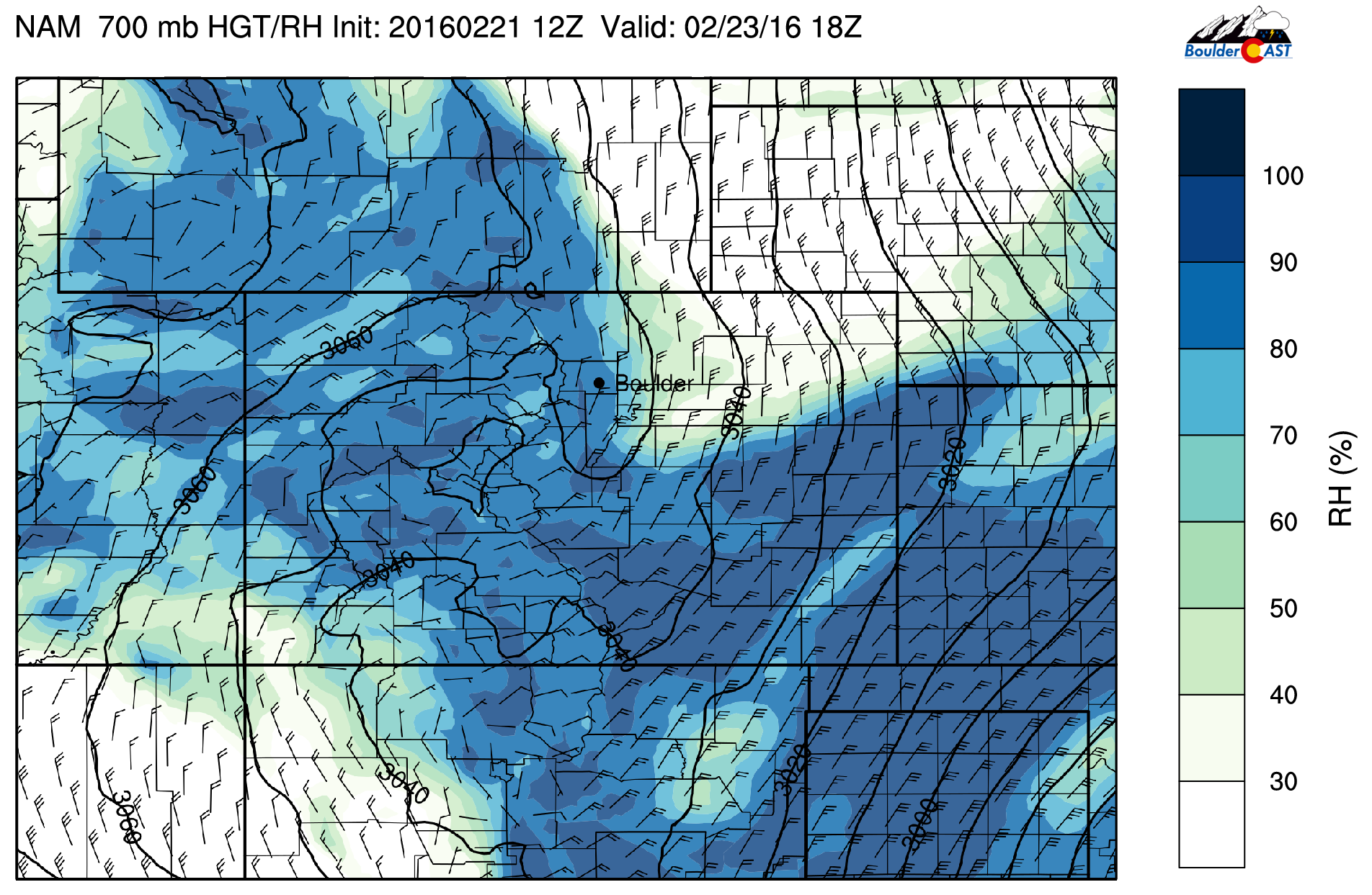
Both the NAM and GFS are showing that the snow growth region (where dendritic snow crystals form in the cloud) will be co-located with the region of maximum lift from the upslope flow. This is shown below. The yellow and pink lines denote the snow growth region, which is typically at temperatures of -12 to -18 Celsius. The red contour lines are the upward motion. Notice how they are co-located from this evening at 5pm to 5am Tuesday morning. This may help increase snowfall rates overnight tonight and potentially lead to fluffy dendritic snowflakes.
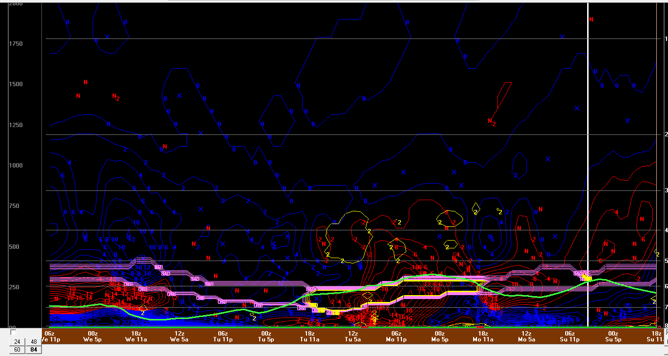
NAM model time / height diagram of snow growth and upward motion for tonight into tomorrow
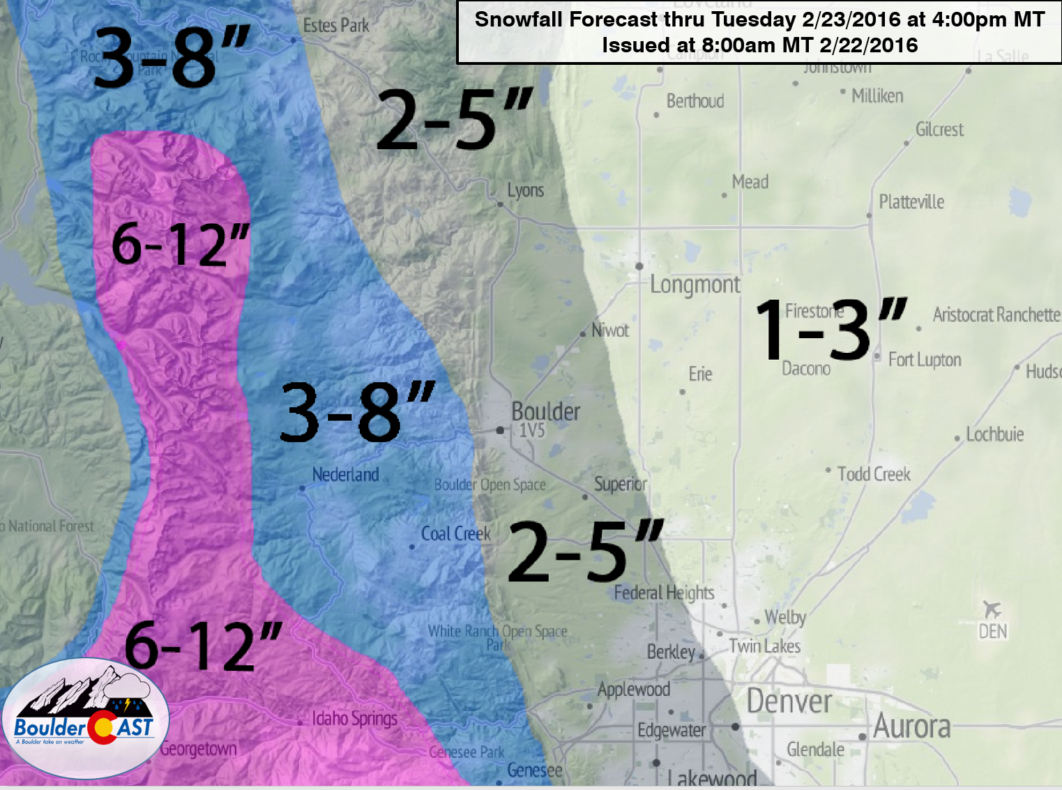
How much snow?
Below shows the accumulated snowfall from the NAM and GFS using our in-house snow-to-liquid ratio algorithm. The GFS is likely overdone on its snow accumulations, as it has 8-10″ over Boulder and 15+ in the Foothills. The NAM model appears more reasonable given the synoptic features of the storm. It shows 4-6″ in Boulder and around 6-10″ in the adjacent Foothills, with 2-4″ in Denver.
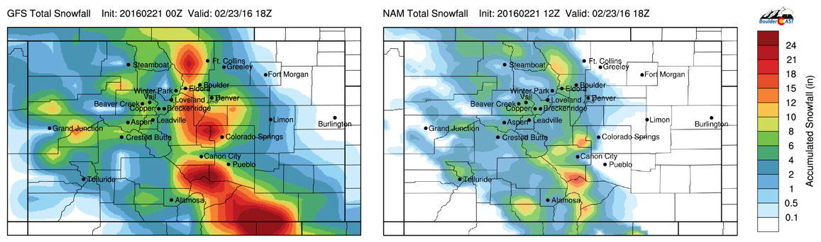
GFS (left) and NAM (right) total snowfall forecast ending Tuesday afternoon
Our official forecast calls for 3-5″ in immediate Boulder area, with 4-8″ in the adjacent Foothills, and 1-4″ in most of Denver. Enjoy the snow tonight! All the details are shown in our snowfall forecast map below. Notice the slight southward bias in amounts, and strong east-west gradient banked up against the higher terrain.
A Chilly Tuesday
After the snow moves through Tuesday morning, northerly winds will remain in place for the afternoon hours, with sunshine slowly taking over as the day wears on. Below shows the NAM forecasted relative humidity at 700 mb for tomorrow afternoon.
NAM 700 mb relative humidity and wind for Tuesday afternoon
It continues to show north-northeasterly winds into the afternoon. The high relative humidity is a good indicator of saturation in the low levels, which will help keep clouds in place. With that and the snow on the ground, temperatures will rise only to the low to mid 30’s tomorrow. Overnight lows Tuesday night will drop into the teens with the fresh snow cover and clearing skies, excellent conditions for radiational cooling.
Moderating temperatures Wednesday to Friday!
Temperatures will moderate the rest of the week and the weather will be rather benign. Below shows the 500 mb absolute vorticity from the GFS for Wednesday afternoon.
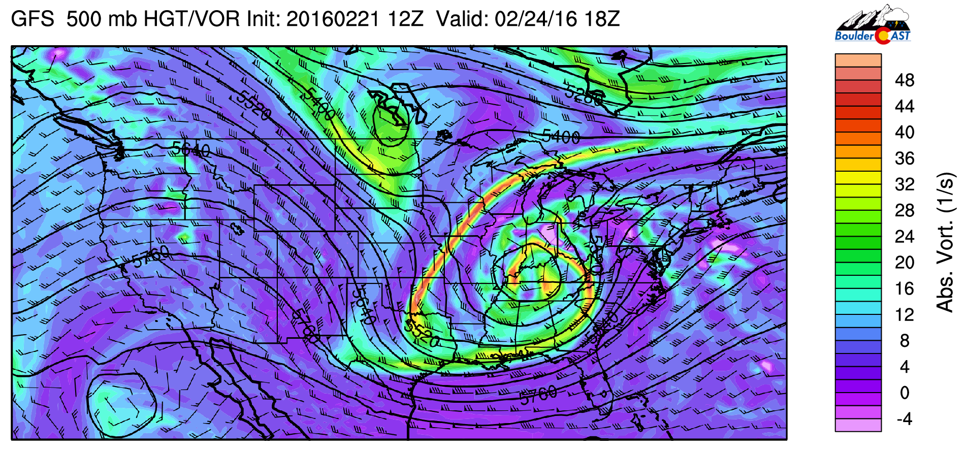
GFS 500 mb absolute vorticity for Wednesday
The shortwave that pushed southeast and affected us Monday has developed into a low pressure system over Kentucky. This system will bring snow to the Midwest and Great Lakes, heavy rain to the Northeast, and severe weather to the Gulf States. Another shortwave is visible over North Dakota, diving south with the upper-level jet streak. Over Colorado, a ridge is building in from the west over Nevada. This ridge will be the story for the remainder of the week, however the jet stream to our east will be close in proximity for the potential of weak, back door cold fronts that could wreak havoc on our temperature forecasts Thursday and Friday.
On Wednesday, downslope flow will ensue as westerly winds take over aloft. Below shows the 700 mb temperature and wind from the GFS model.
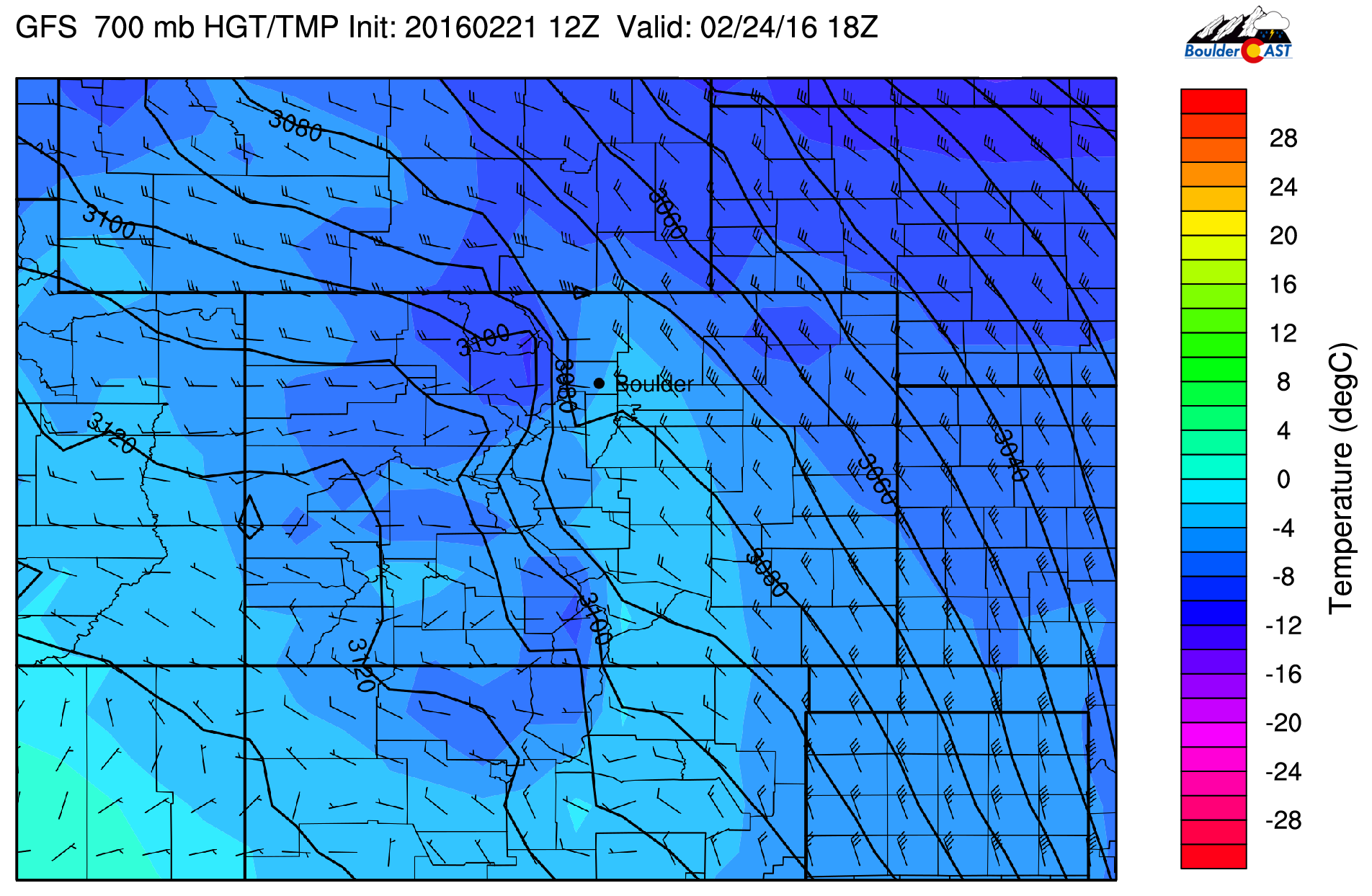
GFS 700 mb temperature and wind for Wednesday
Notice how the height contours are squished west of Boulder in the High Country. The wind barbs also show westerly winds. So this is a signature of downslope flow. Winds are relatively light, though are highest in northern Colorado at 30-40 mph. It is possible Wednesday’s winds could be brisk out of the west with gusts at 20-35 mph. Though, this will help raise the mercury thermometer to near 50 degrees.
As mentioned earlier, the ridge over the western United States will try to push east. However, the trough in the central to eastern United States will remain anchored in place, which will help keep the ridge at bay to our west in Nevada. What that means for us is that the warmth we saw last week will not be returning, at least for this work week. Below shows the 700 mb temperature and wind for the contiguous U.S. for Thursday afternoon.
GFS 700 mb temperature and wind forecast for Thursday
Notice how the cold air is primarily located in the central to eastern part of the country (center of trough), while warmer air is over California (in the location of the ridge). Colorado is at the cusp of both of these airmasses. As a result, temperatures will edge upward, but not significantly. And in the northwest flow aloft, cold fronts could skirt eastern Colorado, but their exact location is difficult to forecast at this time. Our forecast calls for temperatures to reach the low 50’s Thursday and Friday, though they could be slightly cooler if the airmass to our east shifts slightly westward in the later model forecasts.
The Forecast:
Monday: Milky sunshine and mild temperatures near 50 degrees over the Plains and lower 40’s in the Foothills into early afternoon, then cloudy skies with colder temperatures by late afternoon. Light rain or sprinkles in the late afternoon to change to snow by mid-evening and continue overnight. Heaviest snow between 10pm and 6am. Total snow accumulations of 3-6″ for Boulder, 4-8″ for our Foothills, with a general 1-4″ in metro Denver.
Tuesday: Snow in the morning, tapering off by early afternoon, then cloudy skies slowly becoming partly sunny. Chilly, with highs in the low to mid 30’s on the Plains and middle 20’s in the Foothills.
Wednesday: Mostly Sunny, breezy, and warmer. Highs in the upper 40’s on the Plains and upper 30’s in the Foothills. Westerly winds may gust to 20-35 mph in the morning.
Thursday: Sunny and warmer with Highs in the lower 50’s across the Plains and lower 40’s in the Foothills.
Friday: Sunny skies and much of the same as Thursday with lower 50’s over the Plains and lower 40’s in the Foothills.
High Country Forecast: Snowfall will be over the mountains Monday and Tuesday. Total snowfall in the 6-12″ range with locally higher amounts, especially near and south of Interstate 70. Dry weather then takes over Wednesday through Friday.
| Source | Mon | Tue | Wed | Thu | Fri |
|---|---|---|---|---|---|
| BoulderCAST | 50 | 36 | 50 | 51 | 53 |
| NWS | 47 | 36 | 50 | 51 | 55 |
| AccuWeather | 49 | 38 | 50 | 49 | 52 |
| The Weather Channel | 49 | 41 | 53 | 52 | 58 |
.
Last week’s recap:
Here are the results of last week’s forecast. First, the forecasts and observations from all of the sources:
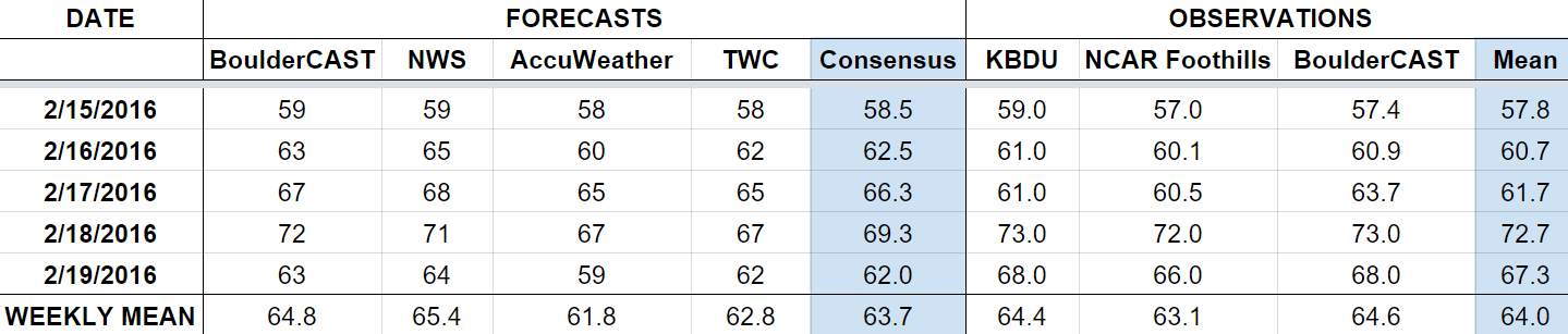
Last week was dominated by a large upper-level ridging pattern, with temperatures soaring beneath. We were forecasting a record high on Thursday, which did verify. Boulder climbed to 73 degrees under the heart of the ridge, eclipsing the 85-year old record of 70 degrees for February 18th. We had no precipitation in the forecast, but Boulder did pick up a few drops of rain on Thursday as well, as extensive spill-over from the Continental Divide extended all the way into the city. 0.02″ was the official total. We also had two wind events in the forecast for Monday and Thursday night. Boulder saw gusts near 60 mph, with a few favored locations nearing 80 mph in the area.
Let’s look at the error analysis. Shown below is the amount of degrees (in Fahrenheit) that each source was off from the mean observed temperature for Boulder. Positive values indicate the forecast was warmer than what actually occurred, while negative values arise from a forecast that was cooler than what was observed.
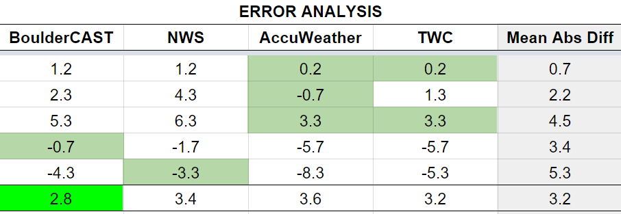
An okay week for everyone. Low error to start the week, with a gradual increase as the week progressed. Friday had ths highest error, at 5 degrees, as temperatures remained warm despite a weak cold front moving through on Thursday night.
The bottom row of the error table shows the weekly mean error for each weather outlet, a good measure for who was the best and more consistent “forecaster” for the week. BoulderCAST takes first again, with 2.8 degrees of error.


