After a breezy and mild Sunday, this week’s weather is all about the wind and warmth. The upper-level jet will be overhead these next few days, producing west-northwest winds as high as 70 mph at times, especially in the Foothills. A ridge then rebuilds by midweek, sending our highs soaring into the low 70’s. Nothing to speak of in terms of precipitation, though the mountains will see some snow. Time to get those shorts out!
Dry, warm, and windy!
As mentioned in last week’s post, a strong mid-to-upper-level ridge has built in across the West. This ridge will be the story for much of this week to keep most areas in Colorado dry (with the exception of the High Country). Below shows the 250 mb wind speeds from the GFS model. The ridge on Monday is centered just west of California. The jet stream is to the north, over Washington and British Columbia, with the eastern extent of the jet sinking south into Colorado.
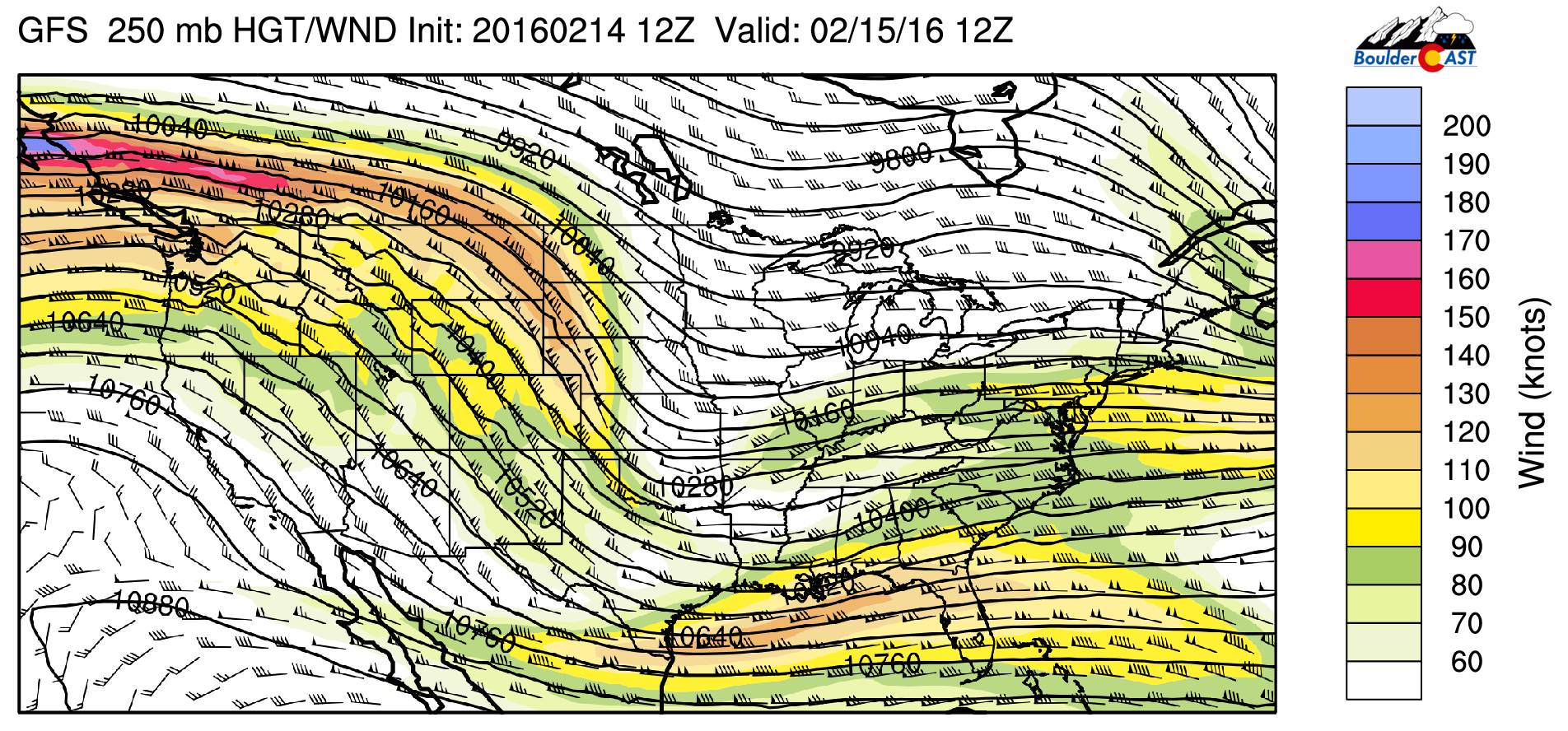
GFS 250 mb wind speeds for Monday
The jet overhead today and tomorrow will result in strong and gusty west-northwest winds. Below shows the 700 mb wind speeds and relative humidity for this Monday and Tuesday over Colorado from the NAM model.
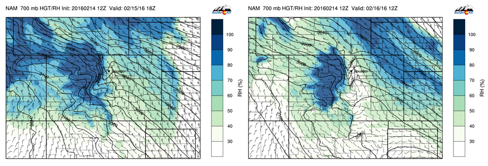
Left: 700 mb winds and RH for Monday. Right: 700 mb winds and RH for Tuesday
Notice how the height contours (black lines) are squished over Boulder and in the Foothills. This is a downslope signature, with the high winds from the jet mixing down to the surface. These wind speeds are about 50 to 60 knots at 700 mb. It’s likely portions of Boulder and the Foothills will see wind gusts over 50 mph today and tomorrow. The upside to the downslope flow is it will lead to adiabatic warming, with temperatures in the low 60’s today and tomorrow. However, the real warm-up comes Wednesday and Thursday.
Finally, note also in the plot how the relative humidity is ~ 90% in the Mountains. The northwest flow will facilitate light snow today and tomorrow with some ski resorts accumulating 2 to 6 inches by Tuesday. If you are skiing for President’s Day, look’s like a powder day, just be sure to dress warm as it will be very windy up there!
The heat is on!
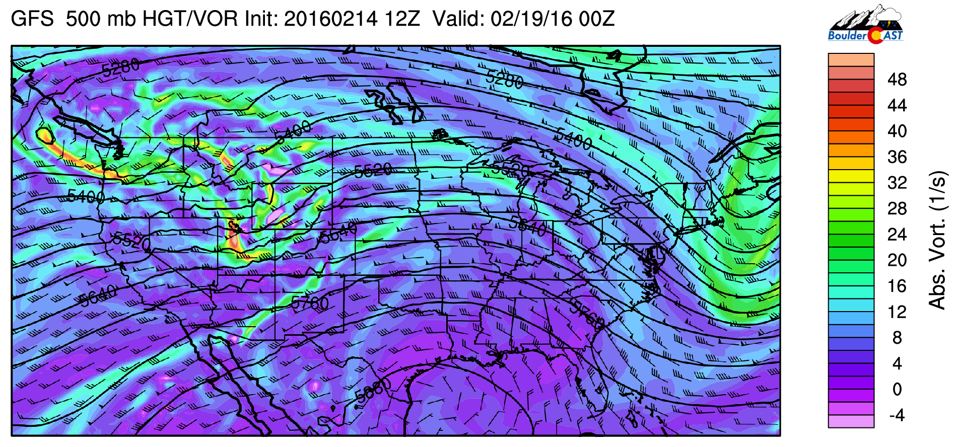
Wednesday starts the true warm-up. That will be the day to bring your shorts out from the winter closet! The ridge pushes eastward from the West, centered right over Colorado, as is evident in the below 500 mb absolute vorticity plot. This ridge will remain in place through Thursday. All is quiet under the ridge, though there is a developing system evident in the eastern Pacific Ocean. That will hit California late Wednesday night and be a player for us on Friday.
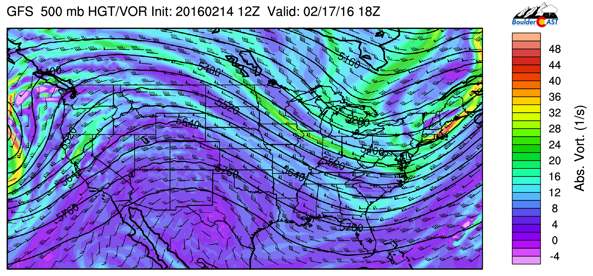
GFS 500 mb absolute vorticity and height pattern for Wednesday
How warm will we get Wednesday and Thursday? Shown below is the GFS ensemble forecast of 700 mb temperatures for Boulder. Typically, we use 700 mb as an indicator of warm or cold air advection and to provide an overall view of the type of airmass over Colorado.

GFS ensemble forecast of 700 mb temperature for Boulder.
As you can see, these temperatures rise to around 4-6 Celsius Wednesday and Thursday, when the ridge is parked over the state. This type of airmass can support highs near 70 degrees Wednesday and Thursday, giving us a shot at setting record highs both days. The chart below shows the potentially record-setting warmth that exists this week.
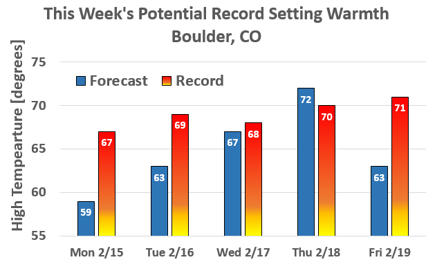
Forecast highs this week vs. records for the dates. Wednesday and Thursday will be close
All great things must come to an end!
On Friday, the ridge pushes eastward into the Midwest. The aforementioned storm system that reaches California Wednesday night approaches Colorado Thursday night and early Friday morning. This is evident below, which shows the shortwave centered over north-central Utah Thursday evening. This storm system will exit the region rather quickly Friday morning. Coupled with the system will be high winds again over Boulder County, with wind speeds approaching 50+ mph potentially. Along with the wind, snow will be present in the higher terrain Thursday night and early Friday. This system will also send a cold front though. However, with the westerly flow remaining, temperatures will only drop to the lower 60’s for high temperatures.
GFS 500 mb absolute vorticity for Friday showing the approaching shortwave trough and the ridge sliding east
As mentioned earlier, the Mountains will see snow Monday and Tuesday, as well as Friday. Below shows the GFS forecasted total snowfall through Friday of this week. A broad swath of 2-6 inches is likely across northwestern Colorado, with the potential for 8 inches near Steamboat. Steamboat is usually a favored area for snowfall on these northwest flow days, so enjoy the powder if you are headed there. Elsewhere, snow is possible in Vail, Aspen, Breck, and Beaver Creek, with some light snow possibly spilling over into Eldora (not much).
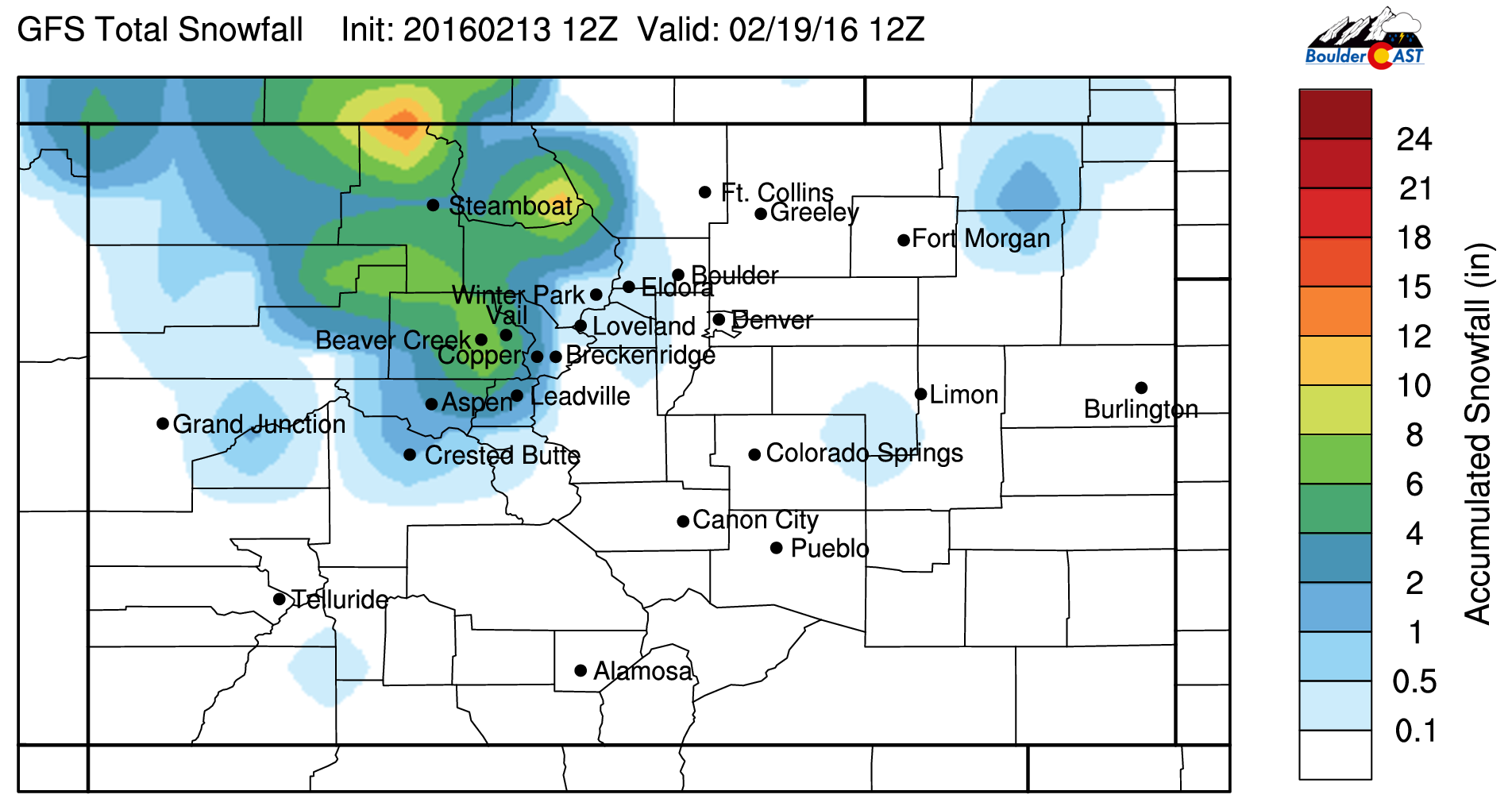
GFS forecasted snowfall for the period Monday – Friday
Enjoy the spring temperatures this week, just be sure to hold on to your hats!
The Forecast:
Monday: High clouds giving way to some sunshine. Mild and very windy, especially in the afternoon and evening. Highs in the lower 60’s across the Plains, with lower 50’s in the Foothills. West-northwest winds gusting to 50 mph at times and over 70 mph in the Foothills.
Tuesday: Partly cloudy skies, windy and warmer. Highs in the middle 60’s over the Plains, with lower 50’s in the Foothills. West-northwest winds gusting to 60 mph in the morning and early afternoon, especially in and near the Foothills.
Wednesday: Mostly sunny, with the wind dying down dramatically. Highs very warm in the mid 60’s on the Plains and mid 50’s in the Foothills.
Thursday: Sunny skies giving way to increasing clouds by evening, Highs again very warm in the low 70’s across the Plains and upper 50’s in the Foothills. West winds will return to gusty conditions Thursday night with wind gusts over 40 mph.
Friday: Windy and cooler with high clouds pushing in for the morning and afternoon. Highs in the lower 60’s over the Plains and low 50’s in the Foothills. West winds gusting potentially to 50+ mph.
High Country Forecast: Windy conditions to persist in the mountains and ski resorts Monday and Tuesday with light snow showers. A broad swath of 2-5 inches of snow possible in northwest Colorado. Favored areas are along and west of the Divide. Expect calm conditions Wednesday, with a return to windy conditions, colder weather, and snow Thursday night and early Friday.
Extended Outlook: Warm weather will continue across the region of the foreseeable future. While the Mountains may pick up some light snow here and there, the Plains will remain dry for at least the next seven days. All models are pointing to the continuation of the ridging pattern across the west for two more weeks. The next hint of something (i.e. snow for everyone) in the models isn’t until the very end of February/first few days of March. Hang in there.
| Source | Mon | Tue | Wed | Thu | Fri |
|---|---|---|---|---|---|
| BoulderCAST | 59 | 63 | 67 | 72 | 63 |
| NWS | 59 | 65 | 68 | 71 | 64 |
| AccuWeather | 58 | 60 | 65 | 67 | 59 |
| The Weather Channel | 58 | 62 | 65 | 67 | 62 |
.
Last week’s recap:
Here are the results of last week’s forecast. First, the forecasts and observations from all of the sources:
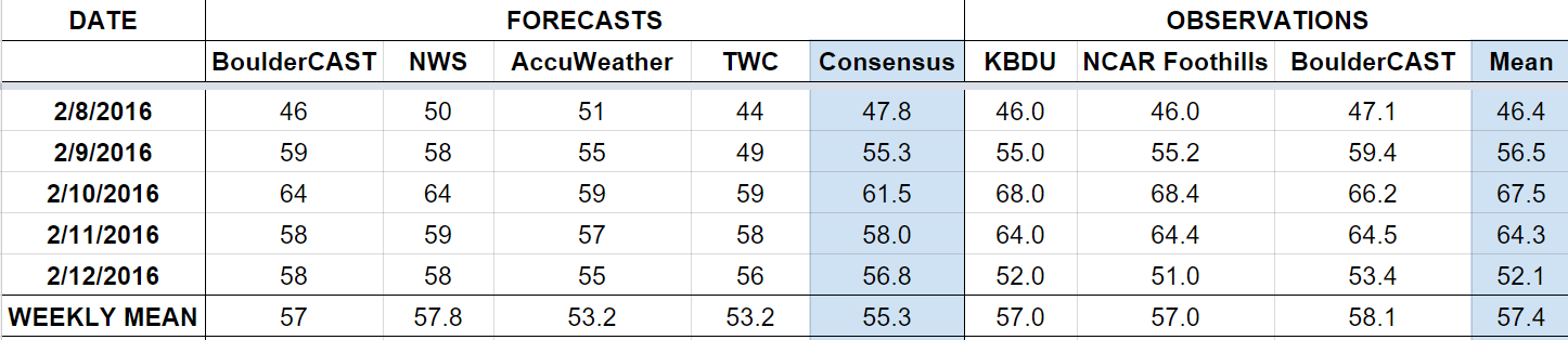
Last week began cooler, but warmed up quick. We preached about the large ridge set to take stage by mid-week, which did verify with two 60+ degree days, including near record-breaking warmth on Wednesday. There was no precipitation in the forecast or observations.
Let’s look at the error analysis. Shown below is the amount of degrees (in Fahrenheit) that each source was off from the mean observed temperature for Boulder. Positive values indicate the forecast was warmer than what actually occurred, while negative values arise from a forecast that was cooler than what was observed.
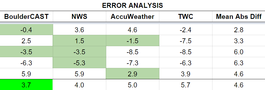
An okay week for everyone. We know the models keep underplaying the warm air and have been for weeks now. We even hedged towards the warmer model solutions this past week, and still came up well short. Both Wednesday and Thursday had large errors exceeding 6 degrees.
The bottom row of the error table shows the weekly mean error for each weather outlet, a good measure for who was the best and more consistent “forecaster” for the week. BoulderCAST is back on top. Our “warm” bias paid off, but we still had 3.7 degrees mean error, definitely something we hope to improve upon this week. NWS came in second, with AccuWeather and The Weather Channel chasing from afar.


