After a snowy holiday weekend, 2015 will go out like a baby sheep, with dry but cold weather prevailing through the week. Read on to find out how cold it will be New Year’s Eve and when we can expect our next chance of snow.
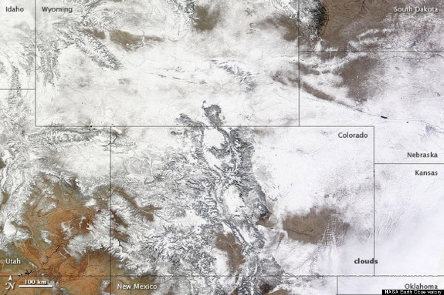
Including our White Christmas, Boulder has accumulated 28.9″ of snow so far this winter (27.8″ at BoulderCAST). With next to no chance of snow before the end of the year, Boulder will rest more than 6″ below normal through the end of December. Not too bad considering the warm autumn drastically limited our snowfall, even into November.
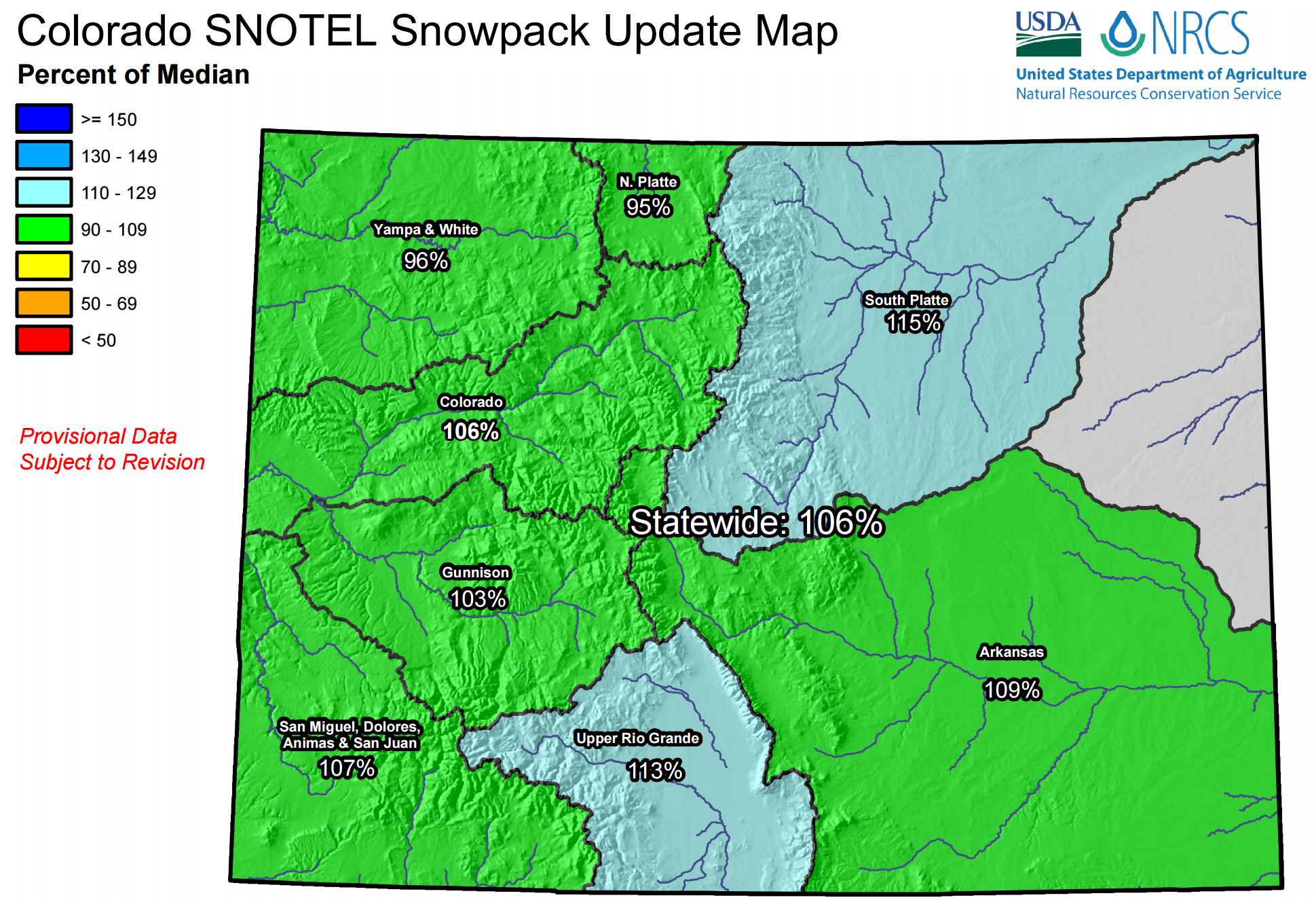
Alternatively, the Mountains are doing just fine, with near or slightly above average snowpack in place across each and every basin in the state.
Drying out
Looking ahead, northeast Colorado will remain under the influence of a broad trough, with the jet stream to our south. The deep storm impacting Texas yesterday with blizzard conditions and deadly tornadoes can be seen to our east in Missouri.

GFS 500mb vorticity map, valid Monday afternoon. Colorado is within the grip of the large scale trough, but between individual pulses of energy.
Notice the overall breath of the trough. It encompasses nearly the entire United States. Within the large trough, a very cold air mass will remain in place across the region. This will keep high temperatures for the Plains in the 20’s through the week, with overnight lows in the 6 to 12 degree range for Boulder.
Several weak, quick-moving disturbances will progress along the base of the trough this week. However, outside of the mountains in western Colorado, they won’t spawn much in the way of precipitation. They will only serve to provide reinforcing shots of cold air. The first disturbance can be seen above over northern California. It will sweep across New Mexico during the day on Tuesday. An associated surface cold front swings south Tuesday morning on the Plains, knocking temps back down after a brief “warm-up” on Monday.
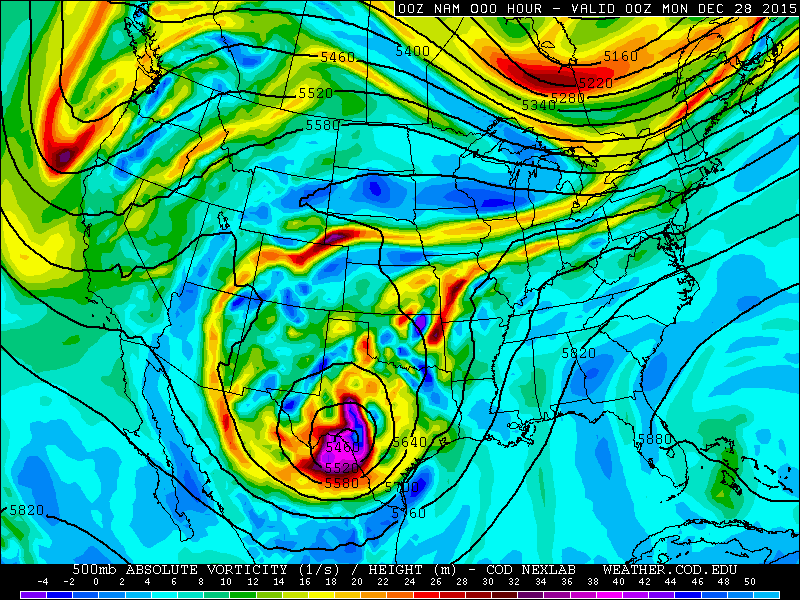
NAM 500mb vorticity map, depicting Monday morning through Wednesday evening. Notice the persistent trough over the West, with a series of colorful storms sweeping through just to our south.
A second, weaker piece of energy moves into western Colorado on Friday. There will be very limited precipitation with this system as well. Therefore, we won’t bore you too much with the fine details of this week’s weather!
Under various, predominately westerly wind patterns, Boulder will remain dry and cold. There will be some sun (Monday and Friday look to have the most), but also plenty of mid and high-level clouds through the week (particularly Tuesday afternoon through Thursday night). No precipitation is expected anywhere on the Plains. Extremely light snow will be possible on the western slopes of the Divide Tuesday afternoon and evening, and sporadically though Friday as the disturbances move nearby.
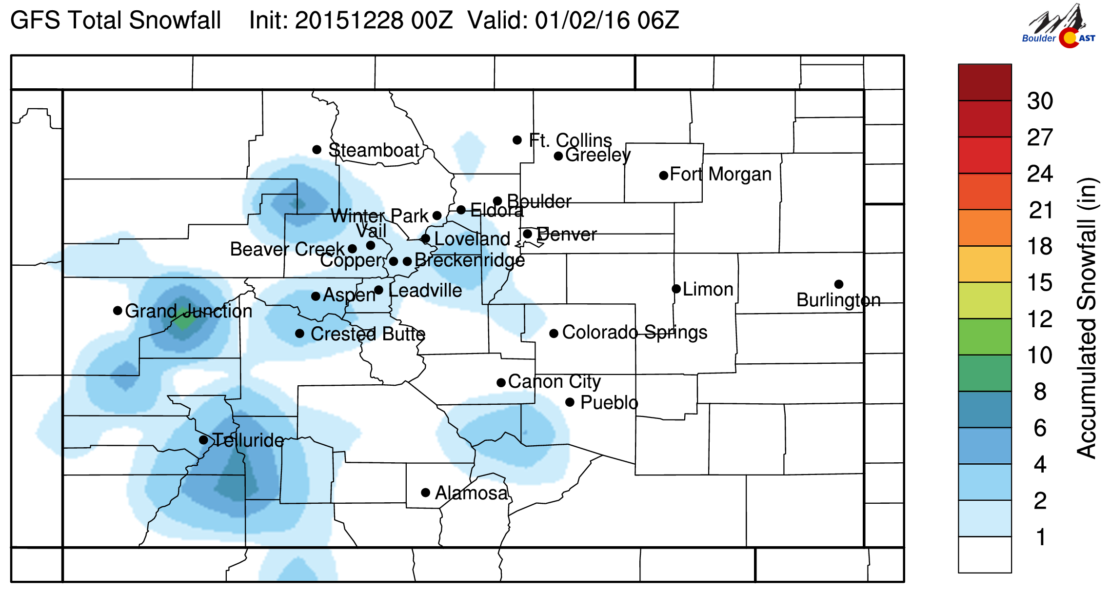
GFS Forecast Snowfall through Friday. Light snow amounts, mostly confined to western Colorado
Snow will mostly be confined to western Colorado and south of Interstate 70.
Change on the Horizon?
There is an interesting trend in many of the models moving into early 2016. The storm track looks to be heading southward, as a split flow pattern develops, bringing systems ashore in southern California and then across New Mexico. This southern route is more of a typical El Niño storm track.
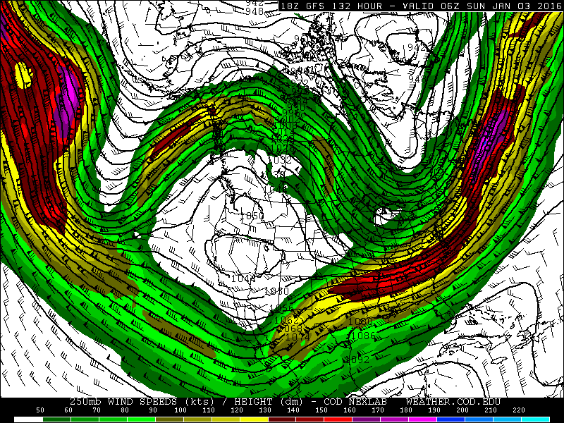
GFS 250mb wind forecast for Saturday evening. Notice the split-flow pattern across the West.
Initially, the split-flow will direct weather away from Colorado, keeping us tranquil for the weekend and into next week. However, the southern fork will definitely bare watching as it is can be more favorable for big snow events across the Front Range. Though, it may end up being too far south to bring much action to our region.
The CPC has also picked up on this shift in the models, painting the American Southwest with increased likelihood of below average temperatures and above average precipitation for early the first ten days of 2016.

CPC 8 to 14 day temperature outlook for January 4-11, 2016. Cool and wet weather are likely across the southwest. Less clear for Colorado.
If anything, Colorado looks to remain relatively cool for the foreseeable future. A few of the models are indicating our next chance of snow may arrive by the middle of next week. Though we are skeptical that New Mexico may get the brunt of it.
With that, we will leave you with wishes of a Happy New Year! If you’re going to be outdoors celebrating Thursday night, don’t rely on your beer jacket. Take a real one! It’s going to be frigid!
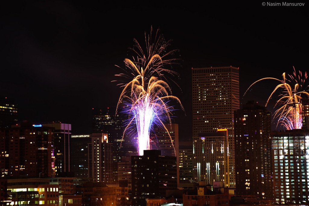
Denver celebrates the New Year
The Forecast:
Monday: Partly sunny. Highs in the low 30’s across the Plains, mid 20’s in the Foothills.
Tuesday: Increasing clouds and cooler. Highs in the low 20’s on the Plains, with upper teens in the Foothills.
Wednesday: Mostly cloudy. Highs in the mid 20’s on the Plains, with upper teens in the Foothills.
Thursday: Mostly cloudy. Highs in the mid 20’s on the Plains, with upper teens in the Foothills.
New Year’s Eve: Conditions will be partly clear and very cold, with no chance of snow. Temperatures in the teens and upper single digits across the Denver Metro area. Be sure to bundle up if you will be outdoors!
New Year’s Day: Some clouds early, with sun taking over by afternoon. Temperatures moderate into the low 30’s for the Plains and into the low 20’s in the Foothills.
Extended Outlook: Slightly warmer (30’s and 40’s) and continued dry weather through the weekend. Our next chance of snow doesn’t arrive until the middle of next week.
High Country Forecast: The docile weather across the Plains will extend to the Mountains as well (mostly). There is a slight chance of snow Tuesday afternoon into Wednesday morning, mostly west of the Divide and south of Interstate 70 with light accumulation expected (a few inches maybe). Surely disappointing the skiers, there are no major snow events on the horizon.
Source
Mon
Tue
Wed
Thu
Fri


BoulderCAST
31
23
26
26
32


NWS
30
22
24
24
31


AccuWeather
33
26
29
26
33


The Weather Channel
29
26
29
29
31
Last week’s recap:
Here are the results of last week’s forecast. First, the forecasts and observations from all of the sources:

Last week began seasonal, and borderline warm, with highs in the 40’s and low 50’s. A frontal passage on Wednesday knocked our temps down a little. We had 1-3″ of snow in the forecast for Christmas Day, and also a slight chance of snow on Wednesday. Both verified quite nicely. Read our recap post on the Christmas Day snow event for more information.
Let’s look at the error analysis. Shown below is the amount of degrees (in Fahrenheit) that each source was off from the mean observed temperature for Boulder. Positive values indicate the forecast was warmer than what actually occurred, while negative values arise from a forecast that was cooler than what was observed.
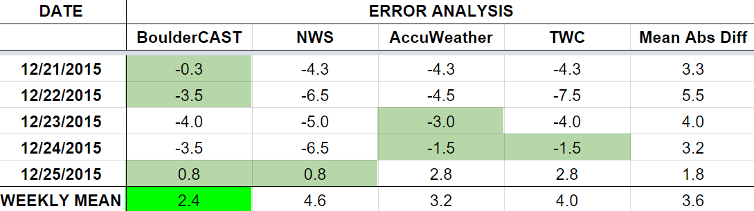
The worst forecast day of the week ended up being Tuesday, with more than 5 degrees of error averaged across the board. Temperatures warmed to 52 degrees (above the forecast of 46). We knew downslope would be in play, but it had a more significant impact that expected. We did have the best forecast (only 3.5 degrees of error) that day.
Once again, it is remarkable that Friday ended up being the best forecast day for temperature. Five days out, the models did a great job this week!
The bottom row of the error table shows the weekly mean error for each weather outlet, a good measure for who was the best and more consistent “forecaster” for the week. We return to first place, with just 2.4 degrees of error averaged across the week. BoulderCAST beat out all of the competition on Monday, Tuesday, and Friday. The NWS lands in last, with nearly double our error (4.6 degrees).


