The week ahead will feature a couple upper-level low pressure systems pushing into Colorado from the west. The first system comes in Tuesday, with a second one arriving for the weekend. This will lead to the chances for showers and occasional storms as well. Mixed in between these systems will be a slight warming trend by week’s end.
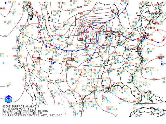
The surface map shown above indicates a cold front that was moving southwest into eastern Colorado as of Sunday night. This front is associated with an area of low pressure over Minnesota and will push through Boulder Sunday night, leading to southeasterly upslope flow during the day on Monday with highs cooler than Sunday.
The 500 mb level vorticity map below shows the upper level low pressure system over California for Monday to start the week. This system will be moving eastward into western Colorado on Tuesday and will lead to rainfall during the morning and afternoon hours on Tuesday for the Plains and Foothills. In this post, we will discuss the impact of this system on the week’s forecast.
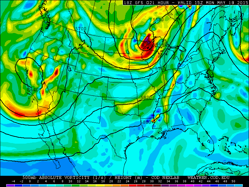
500 mb vorticity map for Monday from the GFS model
On Tuesday the upper level low pressure system will move over Colorado with large scale vorticity advection Monday night and Tuesday morning. This coupled with low-level southeasterly upslope flow over Boulder and eastern Colorado will provide the large scale lift for clouds and precipitation. Moisture will also be fairly high as well. The 500 mb map for Tuesday below shows the large scale lift with the area of low pressure just to the west of Colorado in Utah.
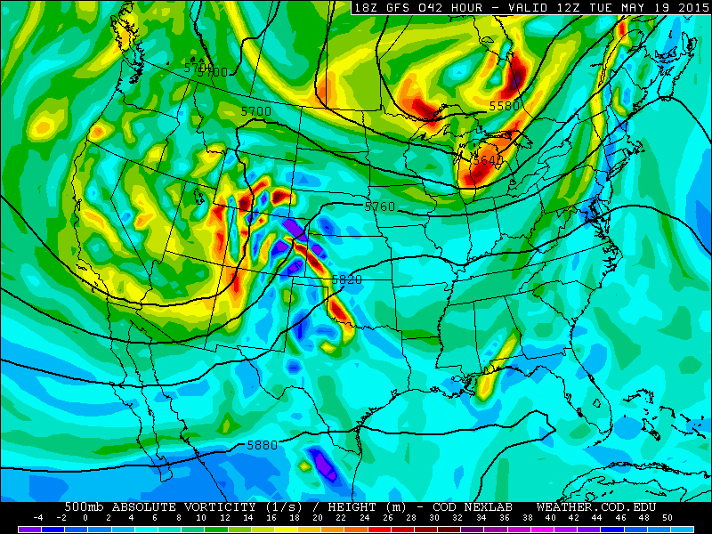
500 mb vorticity map for Tuesday from the GFS model
The below plot shows the 700 mb Theta-E for Tuesday tied to the low pressure system. Theta-E is a measure of both temperature and moisture. High Theta-E values are indicative of increased moisture and instability. There is high Theta-E over eastern Colorado and the High Country on Tuesday. The 850 mb pressure level plot from the GFS for Tuesday is also shown below. It indicates the strong upslope flow (wind speeds up to 20-25 mph) on Tuesday for lift. Both the GFS and NAM forecast models show total precipitation for Boulder County ranging between 1 and 2 inches by the end of the day on Tuesday. This additional moisture could lead to some minor flooding along localized creeks and streams due to the previous active weather pattern we have been experiencing and the already high creeks levels in some parts of our county.
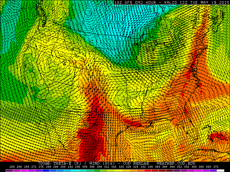
700 mb Theta-E for Tuesday from the GFS model, valid at 6am Tuesady. A warm, moist air mass is advecting into Colorado from the south.
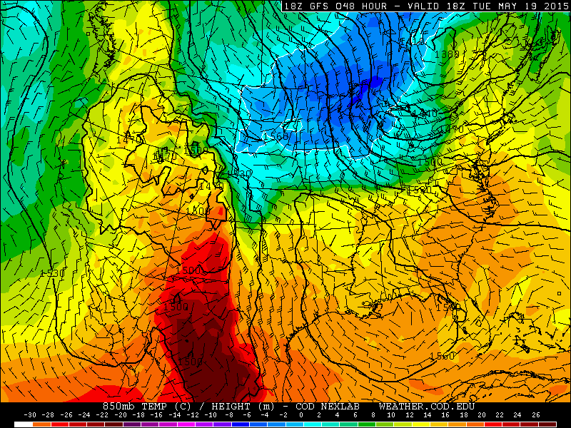
850 mb temperature for Tuesday from the GFS model valid at noon Tuesday. The south-easterly upslope flow in Eastern Colorado is evident.
By Wednesday, the upper level low pressure system will move eastward into Nebraska. This will lead to a drier day on Wednesday. However, afternoon isolated storms cannot be ruled out with moisture and easterly flow still in place.
On Thursday and Friday, we turn to the influence of the second low pressure system that will send two waves of energy to Boulder County. The first wave appears to move in Thursday afternoon/night into Friday morning. A second wave then is on track for Friday afternoon/night into the weekend Saturday. The 500 mb plot for Thursday from the GFS model is shown below. The main area of low pressure will be over California. But ahead of it, southwesterly flow will be over Colorado. A few ripples of energy, evident by the vorticity in eastern Colorado Thursday night, will lead to development of scattered storms in the Mountains Thursday afternoon, which should increase in coverage by Thursday night as it moves east on to the Plains.
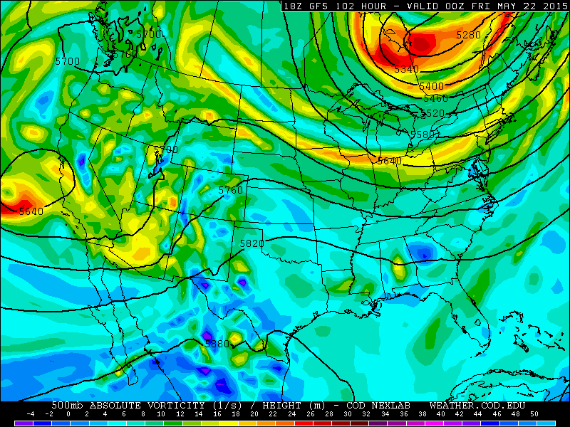
500 mb plot for Thursday from the GFS model
Moisture will also be increasing by week’s end coupled with the secondary low pressure system. The below plot shows the surface level dewpoints for the country. Over Colorado, dewpoints increase to near the low 50’s on Thursday over Boulder County. The dewpoint is a measure of the actual moisture content in the atmosphere, with dewpoints in the low 50’s indicating decent moisture for this time of year. Typically, in the monsoon season (which starts later in the summer), dewpoints can get to the upper 50’s. Therefore, this pattern below means we have decent moisture this week.
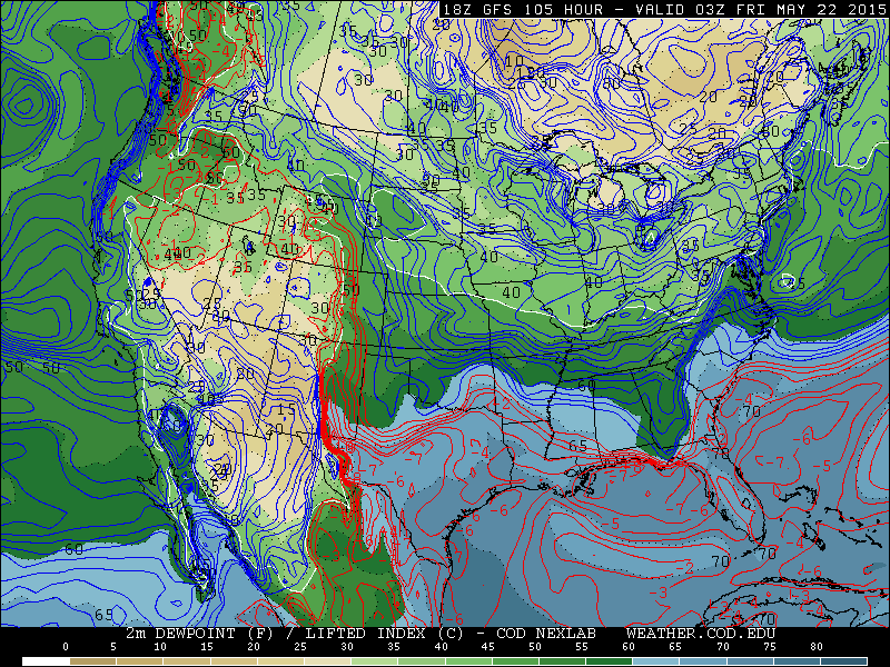
Surface dewpoint temperatures for Thursday from the GFS model
Forecast for the week ahead:
Plains:
Monday: Easterly flow to result in cooler temperatures compared to Sunday in the mid to upper 50’s with cloudy skies giving way to partly sunny skies in the afternoon. After low clouds and some morning drizzle, there will be just a slight chance of a few isolated afternoon showers.
Monday night: Clouds to increase with rainfall developing late Monday night and overnight, some storms are possible.
Tuesday: Periods of rainfall, with the heaviest rain in the morning hours. Highs will struggle to get out of the upper 40’s with the strong upslope flow and cold air pushing in from the north. Rainfall could be between 1 and 2 inches, but should taper off by late Tuesday night.
Wednesday: The first system moves out, temperatures turn warmer into the upper 50’s. Sunny skies will give way to increasing afternoon clouds and some isolated afternoon storms developing with the daytime heating. Overall though, a much drier day than Tuesday.
Thursday: Temperatures warm into the middle 60’s with isolated afternoon storms. A better threat for storms appears Thursday night into Friday morning with the potential for locally heavy rainfall.
Friday: Morning rain followed by isolated/scattered storms in early evening and highs in the upper 60’s.
Foothills:
Monday: Easterly flow to result in temperatures cooler in the upper 40’s under mostly cloudy skies. Isolated afternoon storms around during the afternoon.
Monday night: Rainfall with some storms developing late and overnight.
Tuesday: Periods of moderate to heavy rainfall with some isolated storms as well, highs will be fairly cold for this time of year in the upper 30’s to low 40’s. The snow level should be between 8000 and 9000 ft, so most of the precipitation should be in the form of rain, but the higher Foothills could pick up a few slushy inches.. Rain to continue Tuesday evening ,but taper off after midnight.
Wednesday: Temperatures warmer, rising into the low 50’s with afternoon scattered showers/storm under mostly cloudy skies.
Thursday: Temperatures in the middle 50’s with sunny skies becoming cloudy with afternoon scattered storms. More numerous storms likely Thursday night into Friday morning.
Friday: Early morning storms with highs in the upper 50’s. Another chance of scattered afternoon and early evening storms are possible as well.
Mountains:
The only ski resort left open is Arapahoe Basin. When this post was written, the ski resort was under a Winter Storm Watch for 10 to 20 inches of snow! A-basin will likely see snowfall Monday night and Tuesday, with a likely powder day on Wednesday as snow levels are above 9,000 ft.
As for the mountains in general, Monday will feature isolated/scattered afternoon showers in the high country. More numerous showers and a few storms on Tuesday with significant snow above 9,000 ft. Scattered storms will also exist in the forecast Wednesday through Friday with moisture in place


