Sunny skies and dry conditions have prevailed thus far in August. In fact, measurable precipitation has not been observed in the city since July 21st! Will this trend continue? Read on to find out!
A persistent upper-level ridge has been parked over our region for the two weeks, keeping us high and dry with west-northwesterly flow aloft. This pattern will continue through Thursday. Expect above normal temperatures, in the low to mid 90s, for both Wednesday and Thursday across the Plains.
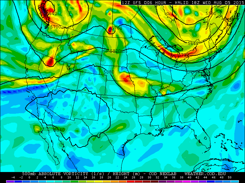
On Friday, the axis of the ridge shifts slightly eastward ahead of a storm system moving ashore in the Pacific Northwest (see below). This will open the door for strong (for August, at least) southwesterly flow and elevated mid and upper-level moisture. Associated clouds and a slightly cooler air mass will knock a few degrees off our high temperatures heading into the weekend as well.

GFS vorticity map valid at 6pm Friday, showing the ridge shifted east of Denver
Friday in Boulder County looks to remain mostly dry, but an isolated, high-base storm in the Foothills/Mountains could spread east onto the Boulder Plains in the late-afternoon. Northeast of Denver, the models hint at the potential for some severe weather as our storms move eastward into a more favorable environment.
Saturday brings the best chance of storms across the Front Range, as precipitable water values climb back to 1.0″ or slightly above. However, expect only widely scattered storms in the afternoon into evening.
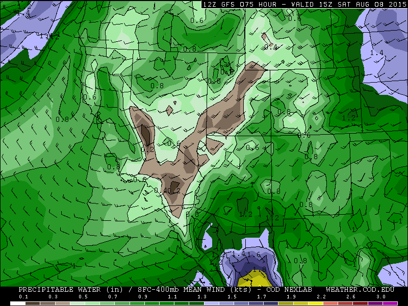
GFS precipitable water map, valid at 11am Saturday
Sunday see the ridge axis begin to retrograde westward again towards Colorado. Drier air will also advect in aloft from the west-southwest. This will reduce our storm chances relative to Saturday. However, it would not be unexpected to see isolated storms fire again, particularly south of Denver and over the higher terrain. High temperatures for Friday, Saturday, and Sunday will be in the upper 80s to near 90 degrees.
The Forecast for Boulder County:
Wednesday: Mostly sunny and hot. A very small risk of a weak storm in the higher terrain. High temperatures in the low to mid 90s on the Plains, mid 80s in the Foothills.
Thursday: Sunny and hot, with no chance of rain anywhere. High temperatures in the mid 90s on the Plains, mid 80s in the Foothills.
Friday: Partly cloudy, with isolated thunderstorms forming in the afternoon. Highs in upper 80s, with low 80s in the Foothills.
Saturday: The best chance of rain for the period. Increasing clouds with isolated to scattered afternoon thunderstorms forming. Highs in the upper 80s on the Plains and low 80s in the Foothills.
Sunday: Mostly sunny and drier, with just a slight chance of an afternoon storm in the Foothills. The Plains will reach near 90 degrees, with low 80s in the Foothills.
Source
Wed
Thu
Fri
Sat
Sun


BoulderCAST
94
94
89
86
88


NWS
93
92
89
86
86


AccuWeather
94
93
91
87
89


The Weather Channel
92
91
89
84
86
Last week’s recap:
Here are the results of last week’s forecast. First, the forecasts and observations:
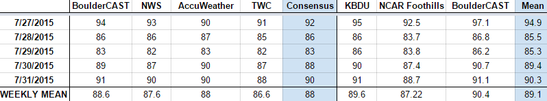
The consensus was for a hot start to the week, with a cold front moving through early on Tuesday, knocking temperatures back into the mid 80s. Thursday and Friday were expected to see temperatures rebound back to near 90 degrees.
Now the error analysis. Shown is the amount of degrees (in Fahrenheit) that each source was off from the mean observed temperature for Boulder. Positive values indicate the forecast was warmer than what actually occurred, while negative values arise from a forecast that was cooler than what was observed.

The bottom row of the error table shows the weekly mean error for each weather outlet, a good measure for who was the best and more consistent “forecaster” for the week. Not surprisingly, the best overall forecast for last week goes to BoulderCAST, with a sizable advantage over the second place contender, the NWS! And for those of you keeping tabs, this is the third consecutive week with The Weather Channel in last place.
—
If you haven’t already done so, follow us on Twitter or Facebook for frequent weather updates and subscribe to the site to get these posts automatically delivered to your email box (enter your email in the sidebar widget to right).


