After a rainy Sunday where Boulder received more than one inch of rainfall and the mountains 8 to 16″ of snowfall, a gradual warming trend is in store this week with the potential for near 80 come Thursday.
Temperatures started out this morning in the upper 30’s to lower 40’s on the Plains of Boulder County. The image below shows the visible satellite as of this morning over Colorado. The large extent of the low level cloud cover is evident, stretching from Wyoming through much of the Foothills, Boulder, and into southern Colorado. The clouds extend westward to near the Continental Divide, with clearing in western Colorado. This is due to the upslope flow still present behind the system that impacted us yesterday. Temperatures will not rise very much today with the extensive cloud cover and chilly northeasterly flow.
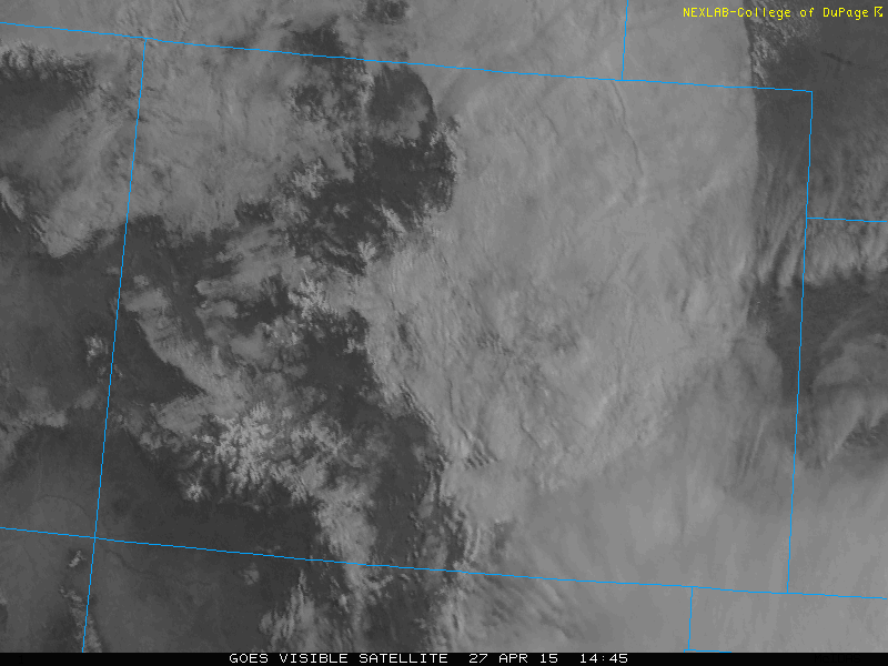
Current visible satellite image over Colorado as of 9am this morning. The low level clouds over eastern Colorado is evident.
Rain will tapper off today as the low pressure system, which was over New Mexico yesterday, moves eastward into the Texas panhandle this afternoon. However, east-northeasterly flow will remain entrenched across northeastern Colorado and Boulder County today, resulting in the continuation of upslope flow. This flow combined with low-level moisture and high relative humidity will result in an overcast day for much of the afternoon. There may be a few peeks of sunshine, but expect clouds to stay socked in. The two maps below show the current position of the cut-off low pressure system and the low-level moisture present in the wake of yesterday’s rainfall. 700mb relative humidity values close to 100% are present across much of the Foothills and northeastern Colorado.
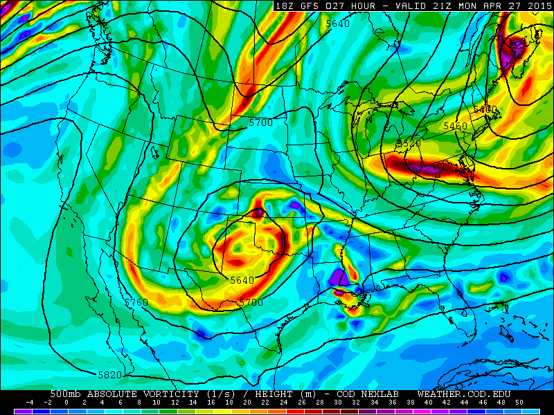
500 mb pressure level map showing absolute vorticity and height contours from the GFS model for this afternoon. The large cut-off low pressure system that affected us Sunday has moved off to the Texas panhandle.

700 mb pressure level map showing relative humidity (in percent) from the GFS for this afternoon. High relative humidity is still in place across the Foothills and northeastern Colorado under northeasterly upslope flow
The forecast Tuesday through Friday shows a gradual warming trend each successive day. The large scale synoptic pattern from the GFS model (below) shows that after the cut-off low exits to our east, a ridge of high pressure builds in from the west. Also, a mid-level trough at 500 mb will be situated across Canada and Montana Wednesday and Thursday. This will result in west-southwesterly flow aloft to induce warm air advection.
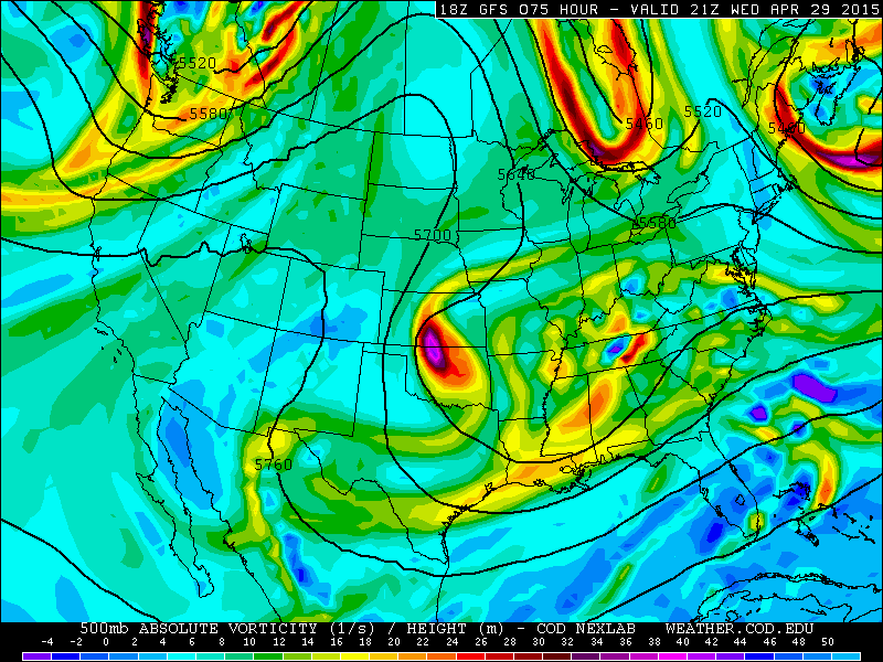
500 mb pressure level map of absolute vorticity and height contours from the GFS model, valid for Wednesday. The ridge over Colorado and the trough over western Canada is evident.
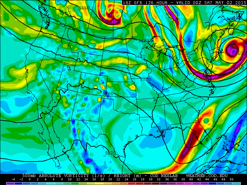
500 mb pressure level map of absolute vorticity and height contours from the GFS model, valid for Friday evening. General troughing is present north of Colorado, from Montana to central Canada, resulting in westerly flow aloft.
A good metric to look at the warming trend for forecasting temperatures in Boulder County is 700 mb temperatures. From there, you can find the potential temperature of an air parcel mixed down from 700 mb to ~830 mb, the approximate surface pressure of Boulder. Potential temperature is useful to examine the potential forecast high each day. 700 mb temperatures start out this week around -1 degree Celsius, then rise to 6 to 8 degrees Celsius by the end of the week Thursday-Friday. A simple potential temperature calculation shows highs will start off in the low 50’s and rise into the 70’s later this week. But of course other factors need to be taken into account when forecasting the high temperature. This is a first order estimate. The below map shows the warming temperatures at 700 mb forecasting from the GFS model for Thursday.

700 mb pressure level map from the GFS model valid for Thursday. Contoured are geopotential heights and temperatures are shaded in degrees Celsius.
One additional factor that will influence our weather late in the week is the potential for a “back door” cold front connected with the upper level trough seen in the 500 mb map above that will move east by Thursday into Montana. The GFS shows a weak cold front in association with this trough, and this front may reach the far eastern fringe of northeastern Colorado Thursday with easterly upslope flow. However, 700 mb temperatures remain fairly warm so this front should not have a huge impact on the forecast. The below map shows the 850 mb level from the GFS model, valid for Thursday, showing wind barbs, height contours, and temperatures shaded. Although Boulder is above the 850 mb level, this level is helpful in examining the frontal boundary location. The front in the GFS extends from eastern North Dakota, southward through western Nebraska and parts of northeastern Colorado. This is evident by the wind shift from southerly to northwesterly.
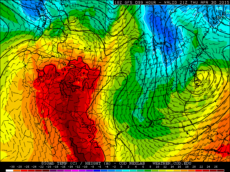
850 mb pressure level from the GFS model, valid for Thursday.
Moisture will be limited by the middle of this week. However, it looks to return come Friday and the weekend in association with the upper level trough shown above. The below figure shows the precipitable water, which is a measure of the total water content present in the atmosphere at a particular time. It shows precipitable water values Friday afternoon rising from 0.2 inches Wednesday to around 0.6 inches on Friday. This increase in moisture, coupled with westerly flow, will lead to the chance of afternoon isolated storms possible Friday and through the weekend.
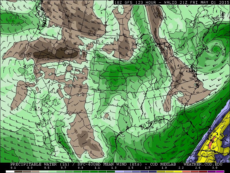
Precipitable Water from the GFS model, valid for Friday.
Forecast:
Boulder:
Monday: Highs to be in the upper 40’s to near 50 today under lots of low level cloud cover and possibly a few peeks of sunshine. Rain will end and leave behind cloudy skies.
Tuesday: A few clouds may be around early, but southeasterly winds will lead to clearing and highs in the low to middle 60’s.
Wednesday: Sunny with highs in the mid 70’s.
Thursday: The warmest day of the week with highs upper 70’s to near 80.
Friday: Much of the same with upper 70’s with a slight chance of isolated afternoon storms.
Foothills:
Monday: Highs in the lower to middle 40’s under overcast skies most of the day and a few sprinkles or light rain showers early, ending by afternoon.
Tuesday: Clouds giving way to sunshine with highs in the lower 50’s.
Wednesday: Highs to reach the low to mid 60’s.
Thursday: Highs in the upper 60’s.
Friday: Upper 60’s with increasing clouds and chances of afternoon storms.
Mountains:
Lingering rain and snow showers will be present across areas east of the Divide today. Tomorrow, the system is long gone, with skies clearing out under high pressure. Moisture increases late in the week — Thursday, Friday, and Saturday. That will lead to the chance of isolated to scattered afternoon storms Thursday and Friday with a snow showers mixed in as well.


