Follow along with us as we provide forecasts leading up to the total solar eclipse on Monday, August 21st for Colorado, Wyoming, and Nebraska. We’re here to help you decide where the best drive-able viewing will be.
*Forecast updates will be included in this post, as needed*
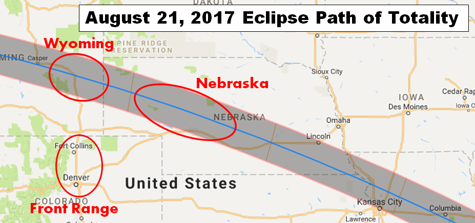
Our forecast for the upcoming total solar eclipse covers THREE different regions (see map below). A majority of our readers are located in the Denver Metro area. As such, your eclipse-viewing will most likely take place in one of the forecast areas outlined below:
- Front Range: This forecast area is for those that are satisfied with seeing roughly 95% totality during the upcoming eclipse, or those that have other obligations preventing travel to the “zone of totality” to our north. This is basically just our normal forecast zone.
- Wyoming: This forecast area is for those that plan to travel to the “zone of totality” via Interstate 25. These folks are the ones that don’t mind sitting in hours of grid-locked traffic to see an astronomical spectacle first-hand.
- Nebraska: This forecast area is for those that plan to travel slightly further to the “zone of totality” along Interstate 76 and 80. These folks are not discouraged by the marginally further drive needed because they know that less traffic will likely make for decreased travel times out and back.
Final Forecast: Sun Aug 20 2017
3:00 PM
GENERAL
Tomorrow is the big day we have all been waiting for!! The Eclipse of 2017 across the United States. As we move into the event, the models have come in much better agreement regarding the atmospheric pattern for Monday. Below shows the NAM and GFS models predictions for cloud cover for Wyoming, Nebraska, and Colorado. If you are still deciding on where to go to see the event, your best best looks to be Wyoming. More details on this below.
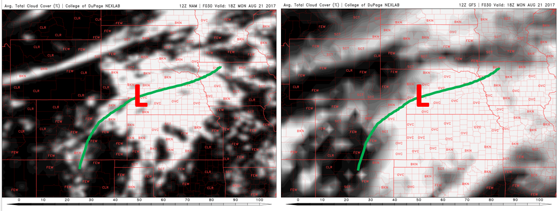
NAM (left) and GFS (right) cloud percentage (%) forecast for Monday during the height of the eclipse. Green line denotes frontal boundary
We believe that Wyoming will have the best potential for clear sunny skies during totality tomorrow, given the position of the frontal boundary. Needless to say, Colorado should also have a good viewing angle with Partly Cloudy skies and 93% totality. Nebraska looks iffy at this point.
Front Range
Morning clouds will likely be present, mid and high level clouds, due to a disturbance tracking along the frontal boundary from Sunday night. These clouds should give way to Partly Cloudy skies though by the time we reach the eclipse in the late morning and early afternoon. We are putting the chance of clouds at around 20%, but there should likely be lots of breaks in the clouds with lots of sunshine to view the eclipse. A few isolated storms will develop later in the afternoon so clouds will redevelop later in the day.
Forecast Confidence: High
Wyoming
High pressure will be in control across much of Wyoming. The frontal boundary will be south across Nebraska, leaving this region is peak viewing territory and lots of sunshine. A few high level clouds cannot be ruled out. We are putting the chance of clouds during totality at only 10%, so should be a great spot to view the eclipse!
Forecast Confidence: High
Nebraska
On Friday, we mentioned the uncertainty with the forecast over Nebraska. This is thanks to a frontal boundary draped across central Nebraska into northeastern Colorado. A warm front over this region will lead to lots of mid and high-level clouds in the morning and early afternoon across central and eastern Nebraska. Some morning fog is also possible. Over northwest Nebraska, however, there is more potential for sunshine as the front is well southeast of this region. We are putting the chance of clouds during totality here at about 50%. Though, we do think there will be a few breaks in the clouds, especially across western Nebraska. Sunshine should eventually take over late in the afternoon with a few thunderstorms possible.
Forecast Confidence: Medium
Forecast Update: Fri Aug 18 2017
1:00 PM
GENERAL
At this point, the eclipse is THREE days away. Models are starting to come into agreement into the pattern for Monday morning/afternoon during the time of the event.
It appears that on Monday, the region of Colorado, Wyoming, and Nebraska will be under the influence of a few systems, most of which will be outside of the domain. Below shows the predicted cloud cover for the U.S. We should focus on Colorado, Wyoming, and Nebraska. This is for Monday afternoon during the eclipse. The GFS depicts Mostly Sunny skies for the Front Range and much of the Plains in Colorado. It predicts scattered clouds across Wyoming and Nebraska.
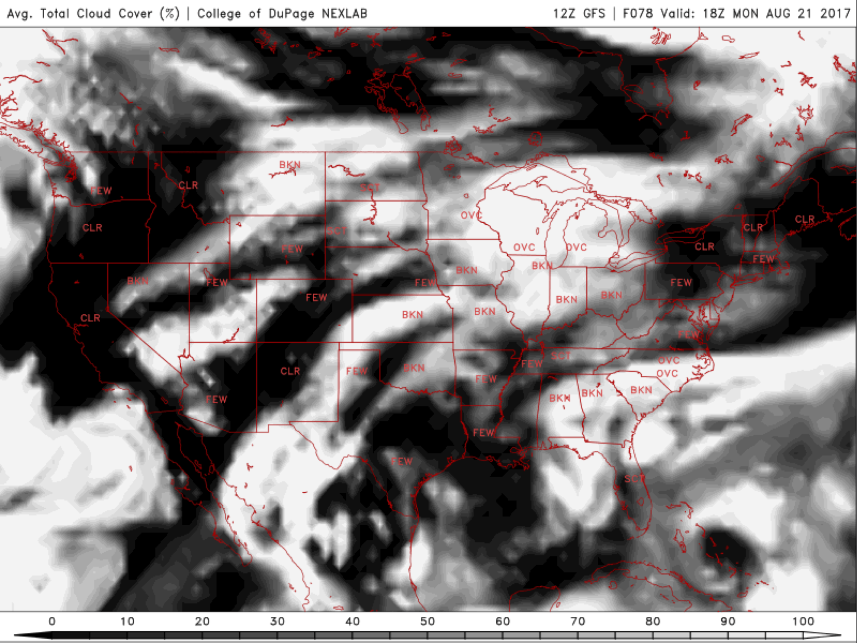
GFS predicted cloud cover percentage for Monday afternoon
Our main concern with the flow on Monday will be the monsoon, which will be located to our south across Arizona, which is slated to potentially bring in a few afternoon thunderstorms to the High Country. Most of these storms should not develop over the Plains until later after the eclipse though. We’re also watching an area of low pressure and frontal boundary across Nebraska and a weak system over northern Wyoming. We will provide updates to the forecast over the weekend.
Front Range
It appears we should see Mostly Sunny skies to start the day with increasing clouds by mid to late afternoon. Monsoonal moisture will stream northward during the day, with thunderstorms possible by late afternoon. During the event, look for Partly Cloudy skies.
Forecast Confidence: Medium
Wyoming
Further north in Wyoming, we will be focusing on a weak trough of low pressure diving down from the northwestern United States. While this system is slated to not reach eastern Wyoming until later in the afternoon, it’s possible this could pose an issue with cloud cover. As we speak, we are calling for Partly Cloudy skies in the morning, mainly mid to high-level clouds, with increasing clouds later in the afternoon with a slight chance of showers.
Forecast Confidence: Medium
Nebraska
The forecast outlook for the Nebraska eclipse region at this point is very similar to Wyoming. An area of low pressure will exist across western Nebraska. This could potentially increase cloud cover predictions during the eclipse, especially in the way of mid and high-level clouds during the morning hours. Our confidence is a little lower for Nebraska at the moment.
Forecast Confidence: Low
Forecast Update: Wed Aug 16 2017
3:00 PM
GENERAL
At this point, the eclipse is still FIVE days away. This is about the time-frame where we would begin to trust what models are showing from a large-scale perspective. The finer details for each location will still need to be ironed out in the coming days. We’ll use the ensemble runs from the models for now to help sift through the uncertainty for you.
Fortunately, it appears all three forecast regions will be in between weather systems on Monday. There will be a large cut-off system over California and a broad ridge across the Gulf Coast. Across CO/WY/NE, tame westerly flow aloft will be in place with virtually no upper-level forcing to support precipitation.
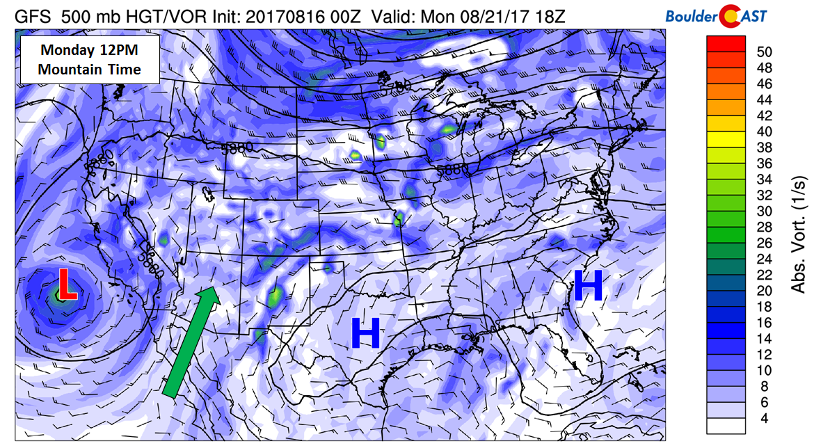
Our main concern with this mid-level set-up is that the position of the trough and ridge would act to funnel moisture northward, reviving monsoonal flow to the Desert Southwest and possibly Colorado. While right now it looks like the bulk of the moisture won’t make it northward to the eclipse-region until Tuesday or Wednesday, the timing could change considering the lead time on this forecast.
Front Range
It looks as though the monsoonal moisture will push north only as far as southern Colorado by Monday. A few isolated storms could form across the Front Range Monday afternoon, though. The weak steering flow aloft should keep most of this activity across the higher elevations. Your best bet to see the eclipse without puffy cumulus clouds blocking your view is to be as far from the Foothills as possible. The chance of rain during the eclipse is very low, but there is some model indication of a cirrus cloud deck setting up “somewhere” on Monday. We expect this to be north of the Metro area, but it’s still too early to say for sure. The high temperature should be near 90 degrees.
Forecast Confidence: Medium
Wyoming
Further north in Wyoming, rain chances will be even lower than the Front Range. However, we’re concerned there could be some high-level cirrus on Monday morning and afternoon. It’s really too early to say how extensive this cloud cover may be and where it sets up. Temperatures in this forecast region will be in the 80’s.
Forecast Confidence: Medium
Nebraska
The forecast outlook for the Nebraska eclipse region at this point is very similar to Wyoming. While we don’t expect any rain, we’re admittedly also concerned about mid and high-level cloud cover potentially being a factor during the time of totality. We’ll need to monitor this region as it could go either way at this point given current model runs. Monday’s temperatures will reach into the lower 90’s in this region.
Forecast Confidence: Medium
No prior forecasts available.


You must be logged in to post a comment.