Models finally came into a snowy agreement last evening and unfortunately this means we have another round of snow to deal with Wednesday afternoon and evening, one which may turn out quite similar to what transpired on Monday. Read on for our full forecast, including when the snow will start and how much to expect in your area.
We discuss Boulder and Denver weather every single day on BoulderCAST Premium. Sign up today to get access to our daily forecast discussions every morning, complete six-day skiing and hiking forecasts powered by machine learning, access to all our Front Range specific weather models, additional storm updates and much more!
Today only, save 25% on an annual subscription with promo code NOMORESNOW.

Today’s forecast update for another round of snowfall shouldn’t be a total surprise, at least if you are a BoulderCAST Premium subscriber or happen to follow us on Facebook or Twitter! We’ve been relaying all week long the message that this particular snow event was highly uncertain and that a bulk of the weather models did not agree on a common solution. This finally changed in Tuesday evening’s model runs, where a snowier outcome became clear.
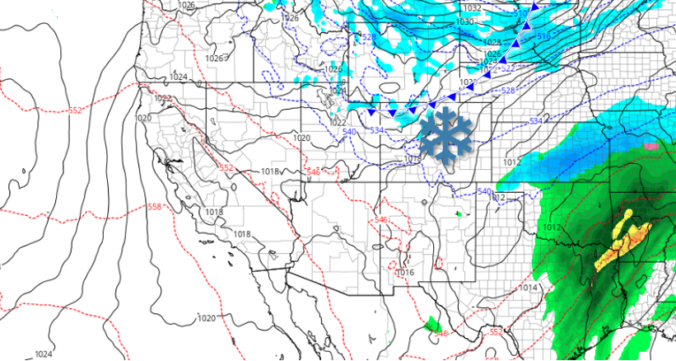
On paper, this particular storm system doesn’t look all that impressive. The NAM 500mb vorticity map below shows the large-scale setup: a run-of-the-mill shortwave dropping south out of western Canada and into Colorado. It doesn’t have that much moisture. The associated jet is weak. The upslope isn’t all that deep or favorable.

NAM 500mb may for early Wednesday showing the approaching shortwave to our north
So what changed in recent model runs? We believe the biggest factor the weather models have finally zeroed-in on this morning is the positioning of an Arctic cold front associated with the incoming shortwave. There had been vast differences in exactly how far west this front would stretch. Would it fully engulf northeast Colorado or would it only skirt the area? The shift in a few hundred miles has clearly made all the difference, with bonus low-level moisture, lift from the front itself, and added upslope, we now have a real snow event on our hands!

GFS 800mb temperature forecast map for Wednesday morning. A strong cold front will surge southward into our area later today
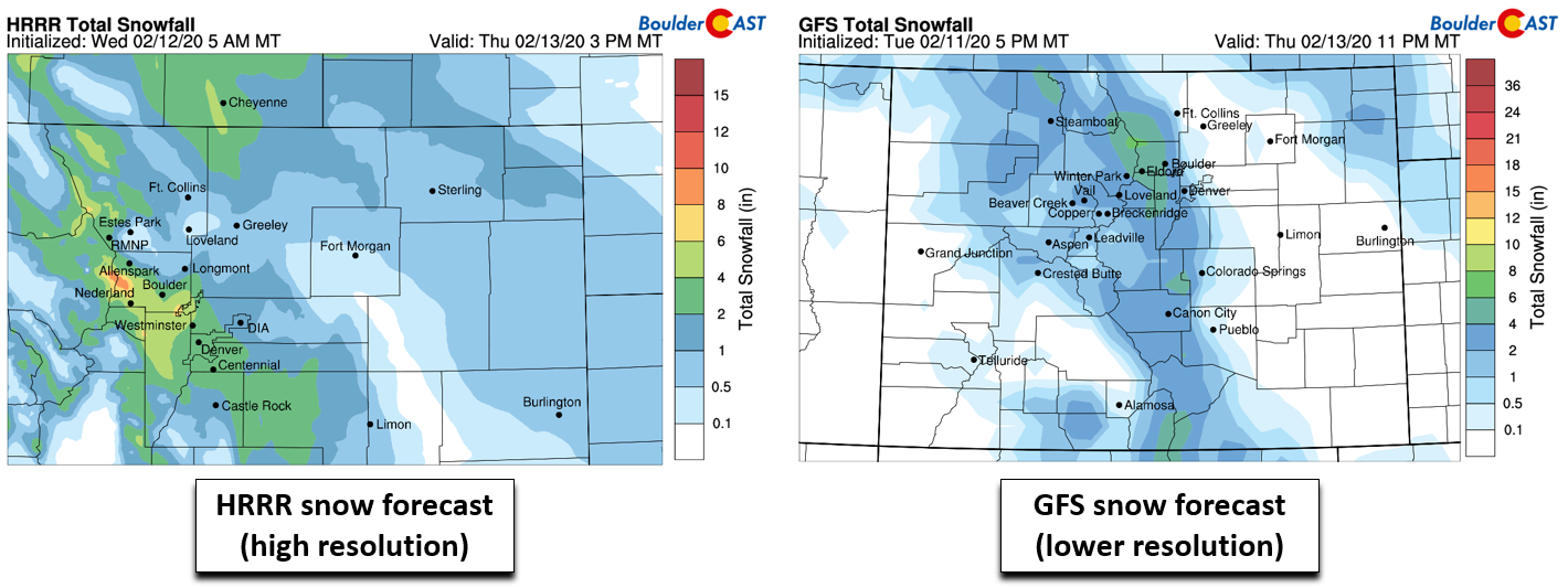
We preface by saying that our confidence in the forecast for today is low to medium. There is still some model disagreement, particularly between the high-resolution and low-resolution models. This isn’t necessarily unexpected. There are multiple aspects of the setup too small to be fully resolved by the lower-resolution models, such as the forcing from the left-exit region of the jet (see below) and also the shallower Arctic airmass. We’re going to rely more-so on higher-resolution models, like the HRRR and NAM-NEST, to guide us this time around (both of which are showing several inches of snow for today).
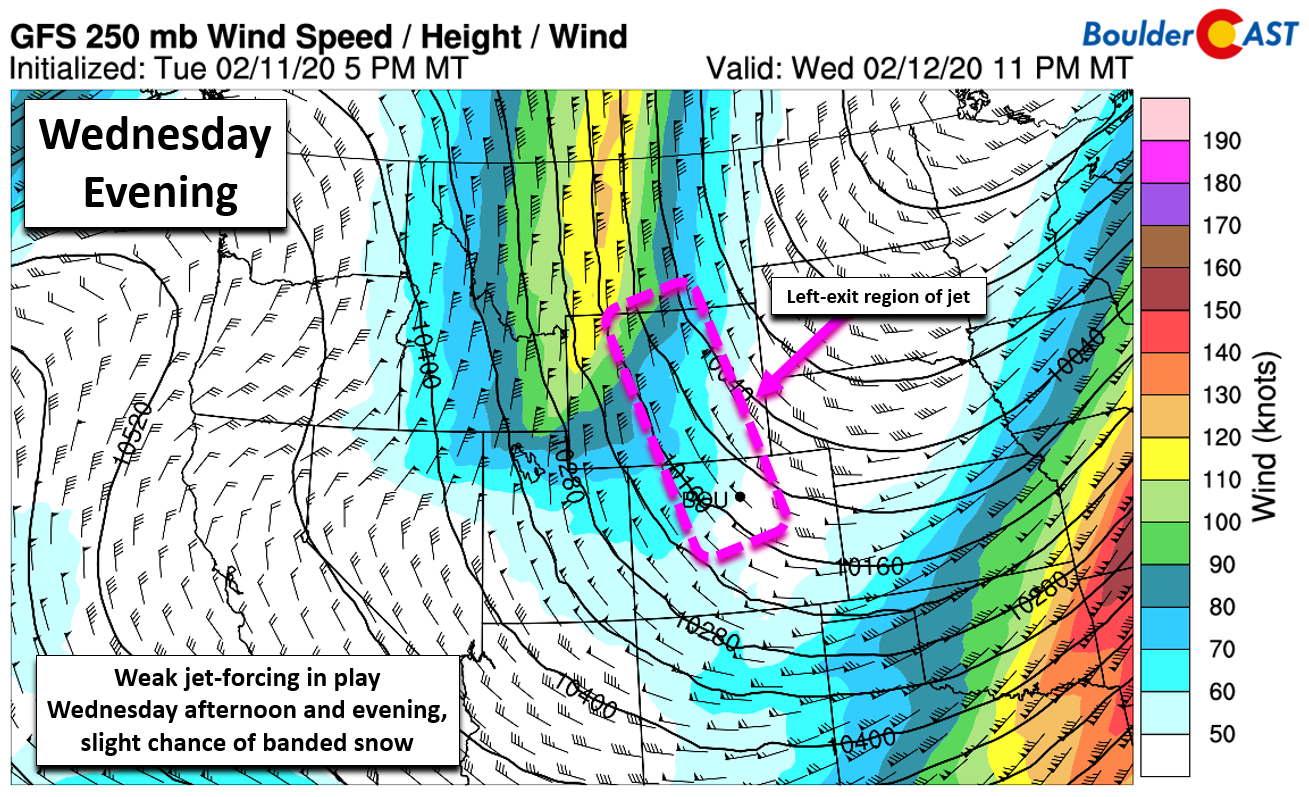
GFS 250 mb wind forecast map for Wednesday evening. North-central Colorado will be in the left-exit region of the jet
Timeline
Wednesday will be another cold day with highs reaching only the low to middle 30’s. Mostly cloudy skies in the morning will become even cloudier through the day, along with increasingly gusty north winds. The ingredients for snowfall all begin to come together by early afternoon with snow likely to break-out across the Foothills and Denver Metro area shortly thereafter. Snowfall could be heavy at times considering the factors at play, especially during the late afternoon into evening. The HRRR model tends to focus the heaviest snow west of Interstate 25 and south of US-36. This positioning is likely the result of the north-northeasterly upslope which would favor this area. Watch out Arvada, Golden, Boulder, Lakewood, and in the Foothills!
Obviously this timing isn’t great for the Wednesday evening commute, especially for areas that see the heavier bursts of snow which models are advertising for the timeframe. You may want to consider leaving work a little early as roadways could become very slick and at least partially snow-covered before rush hour. Nothing is posted yet, but it wouldn’t be in any way surprising to see the National Weather Service issue a Winter Weather Advisory for this afternoon and evening given the poor timing. Snow will taper off around or slightly after midnight for most areas.
After the snow, know that this Arctic airmass is the real deal. Skies are expected to partially clear overnight in some Front Range cities. This will allow temperatures to plummet to bone-chilling levels…into the lower teens nearly everywhere and well into single digits for locations that see significant sky clearing. Thursday morning will definitely FEEL and LOOK like winter!
Snow Amounts
This snowfall event shares a lot of similarities with the one that occurred on Monday. It’s a quick-hitter with only 8 to 12 hours of snow, has the cold air, and even some bonus lift from the front/jet compared to Monday. The only downsides are less moisture overall and a less favorable NNE upslope direction (which will actually downslope the far northern Metro area). Our snowfall forecast map for the event is shown below. This covers snowfall through Wednesday night.
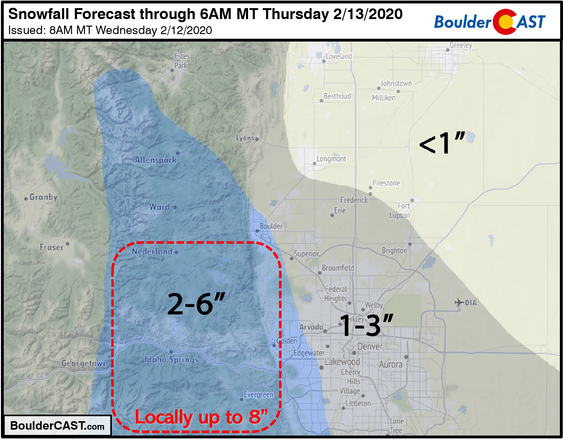
Our confidence in exactly how this snow event will play out Wednesday is lower than usual due to aforementioned factors. Locally up to 8″ or so is possible somewhere in the red box where high-resolution models continue to target with slow-moving moderate to heavy snow bands. Furthermore, areas east of Interstate 25 definitely have better chances of ending up closer to 1″ than 3″. It’s a tricky forecast today to say the least, but that’s our best shot at it!
Are you as tired of shoveling snow as we are? If so, we do have some good news! Today’s snow event should bring to an end the onslaught of “every other day snow” we have been enduring for nearly two weeks now. Though the pattern will remain somewhat active, nothing looks like a snow-maker in the near-term. Our next chance of white stuff likely doesn’t come until late Sunday or Monday alongside another very cold system dropping out of Canada…
—
We discuss Boulder and Denver weather every single day on BoulderCAST Premium. Sign up today to get access to our daily forecast discussions every morning, complete six-day skiing and hiking forecasts powered by machine learning, access to all our Front Range specific weather models, additional storm updates and much more!
Today only, save 25% on an annual subscription with promo code NOMORESNOW.
Subscribe to receive email notifications for BoulderCAST updates:
We respect your privacy. You can unsubscribe at any time.
.
Spread the word, share the BoulderCAST snow forecast!


You must be logged in to post a comment.