The El Niño that has been with us for the last seventeen months has finally met its demise. The atmosphere is in the process of responding to this change as we speak. We provide an update on the situation as we begin our transition into a La Niña pattern. We also review how well our late-winter predictions verified. Read on for our full outlook for the remainder of the summer season.
This content is available exclusively to BoulderCAST Premium members until June 30, 2016
Reviewing our late-winter outlook
When we last checked in on it, we declared that the 2015-2016 El Niño was, by many accounts, atop the record books in strength (which only go back to ~1950). We stressed all along that late-winter could be the time where El Niño makes the biggest impact. It did not disappoint!
Here are the specific predictions that we made, taken from our previous post. Red text details how well each prediction ultimately verified.
Projections made in early February 2016:
- A strong to moderate (but weakening) El Niño will persist at least through April [Verified. Didn’t weaken below moderate status until the tail-end of April]
- February will likely end up well above normal for temperature, with very minimal snow during the remainder of the month [Verified. Boulder ended February more than 5 degrees above normal, the 11th warmest on record. 5.2″ of snow fell during the last 27 days of the month, which is well below normal]
- For March, we are expecting above normal snowfall and below normal temperatures. Our best odds of a big snow storm will be this month. [Verified. 33″ of snow fell in March, nearly double the average amount. Two big snow events occurred during the month…16″ and 14″]
- April is a little more ambiguous, but we will hedge towards slightly below normal temperatures with near normal or slightly above snowfall. [Partially verified. April ended about as normal as could be for temperature. Snowfall in April ended well above normal]
- For the February, March, April period in general, we are forecasting slightly below normal temperature and above normal snowfall [Partially verified. We ended slightly above normal in temperature for the period. Snowfall concluded WAY above average]
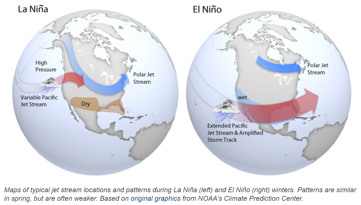
El Niño La Niña update & forecast
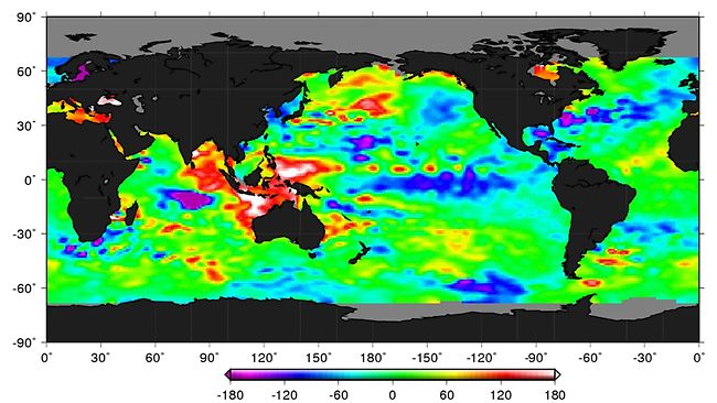
Remember that an El Niño is comprised of warmer than normal ocean temperatures along the equatorial Pacific Ocean. In the animation below of sea-surface temperatures spanning the last six weeks, notice how the warm anomaly along the Equator (oranges and reds) has weakened and largely been replaced with a cold anomaly (blues). You are witnessing the death of a great El Niño!
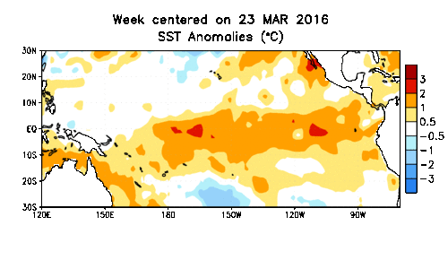
Looking specifically at the NINO 3.4 region of the Pacific Ocean, the sea-surface temperature anomaly dropped from an astonishing +3.1 degrees in November all the way below zero by the latter half of May (seen below in blue area).
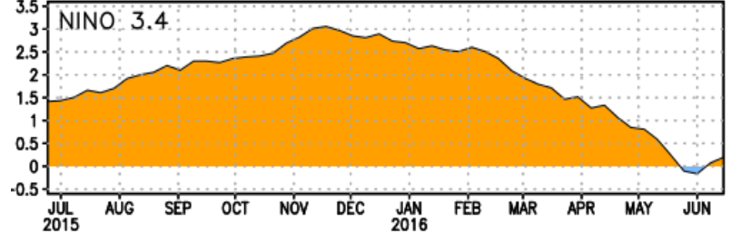
With this value currently at +0.2 degrees Celsius, we are officially in ENSO neutral conditions, meaning ocean temperatures across that region are more-or-less normal for this time of year.
However, most of the guidance out there suggests conditions will slowly slide into a La Niña (cold anomaly) through the summer. This often occurs in the wake of stronger El Niños, a result of planetary-scale ocean waves that propagate along the Equator in the Pacific Ocean. The plume diagram below depicts the forecast temperature anomaly in the NINO 3.4 oceanic region from numerous atmospheric/oceanic models. Look at that downward trend!
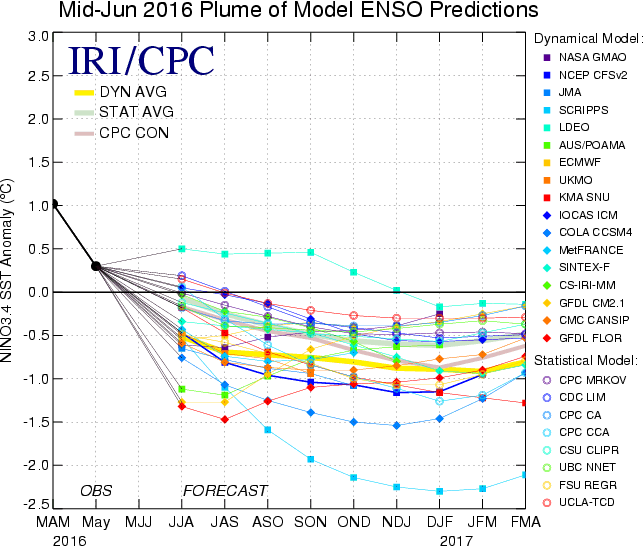
As is normally the case, there is a bit of a disconnect between the statistics-based models (average shown by the bolded yellow line) and purely dynamics-based models (average shown by the bolded light green line). In our opinion, the dynamical models tend to do a better job, so we’re leaning more towards a weak La Niña (-0.5 to -1.0 degrees Celsius) for this fall and winter, with neutral conditions for the summer months as the transition happens. Earlier speculation was that this upcoming winter could cascade into the polar-opposite scenario to last year, a very strong La Niña. However, this no longer looks like a viable outcome
Long-range outlook for the rest of summer
Just as the presence of warm ocean waters during El Niño can alter global atmospheric circulations (leading to weather changes in Colorado), the rapid reversal of these conditions can cause effects on global weather patterns as they adjust to this change. Despite no specific signature for ENSO-netural during the summer season in northeast Colorado (as you will see below), if the equatorial Pacific cools quickly over the next month or so, La Niña could become a weak player in our weather this summer.
Let’s dive into Boulder’s historical weather record and see if there are any significant ENSO-related signals in the next few months…
Precipitation:
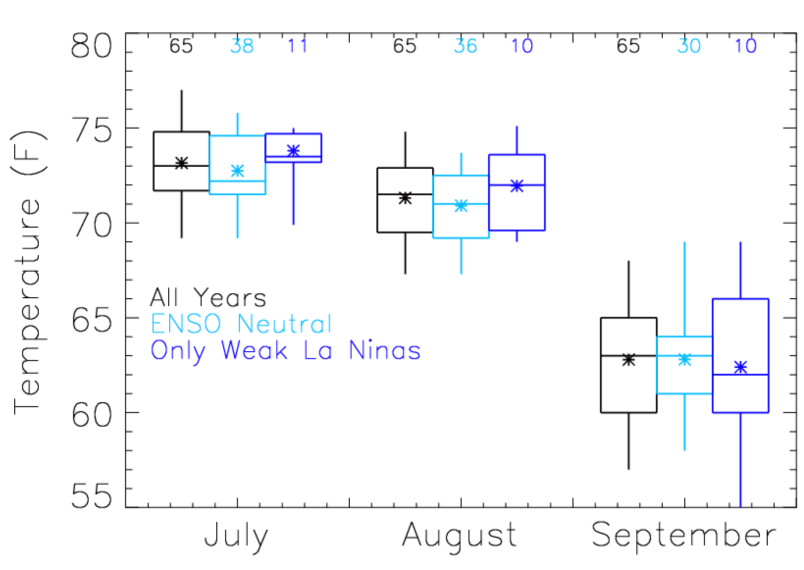
The figure below shows box-and-whisker plots of precipitation for Boulder for the monthly totals of July, August, and September. The black box-and-whiskers contain monthly precipitation totals for all years, stretching back to 1950. The light blue plots show only the months for years where ENSO-neutral conditions were present, while the dark blue plots represent months where a weak La Niña was present. The numbers at the top of the figure indicate how many years those particular conditions occurred (data from official Boulder climate site at NOAA).
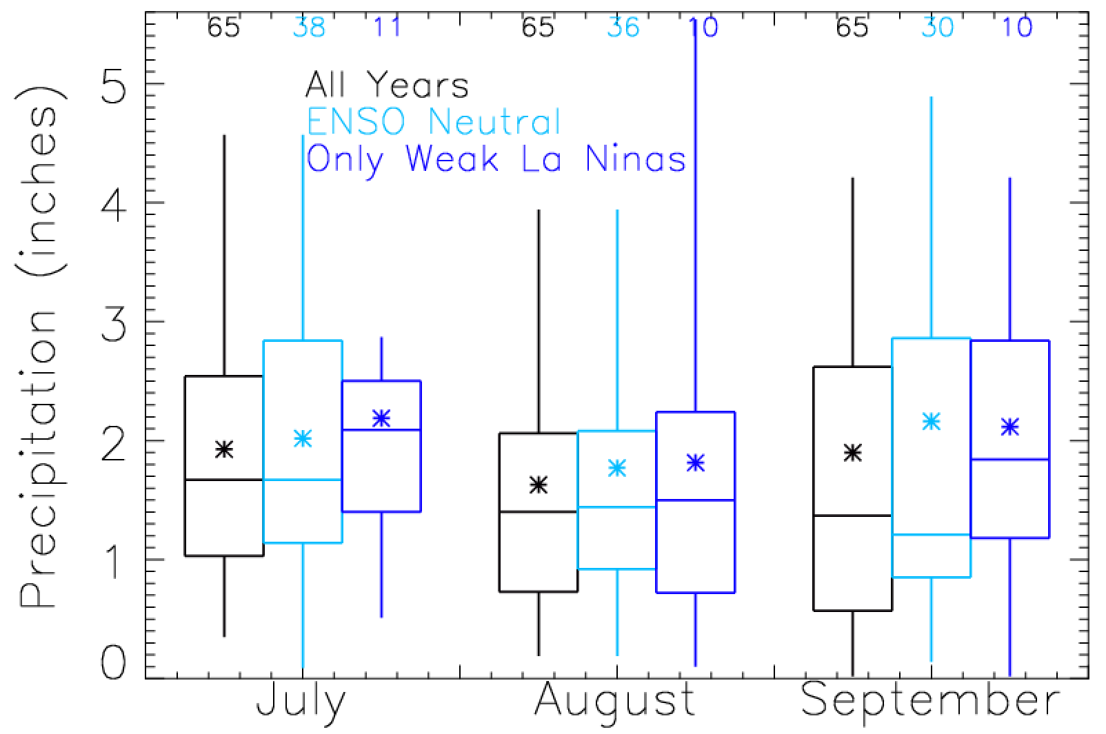
With July nearly upon us, it’s safe to say we’ll likely remain ENSO neutral during the upcoming month. This assumption doesn’t shed much light on the potential for precipitation in July, as ENSO neutral conditions (light blue) are not any different from normal (black). Let’s also assume that August stays ENSO neutral. Again not much of a signal in Boulder, with only a slight (not significant) increase in precipitation relative to normal. Finally, based on the forecast plumes in the previous section of this post, it is likely September will see a weak La Niña in place. The box-and-whiskers for September shows a bump in median precipitation, on the order of about one-half inch, for La Niña Septembers relative to normal in Boulder.
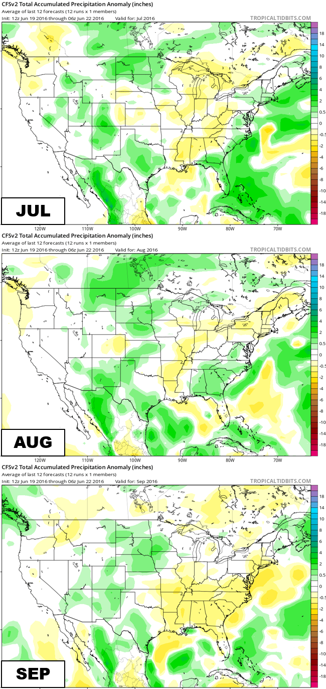
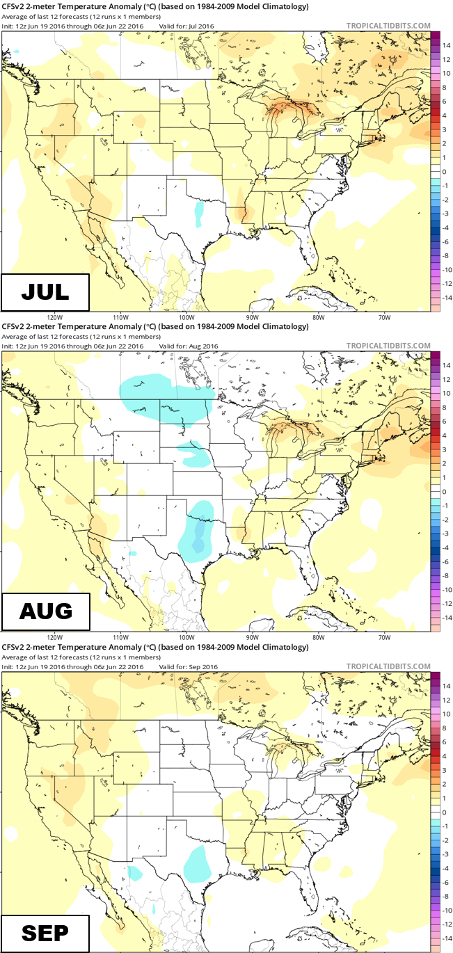
One of the most trusted climate models, if there is such a thing, the CFSv2 model, is projecting right on par with our ENSO statistics for Boulder (as you can see below). The model predicts normal precipitation for July, below normal precipitation for August, and above normal precipitation for September.
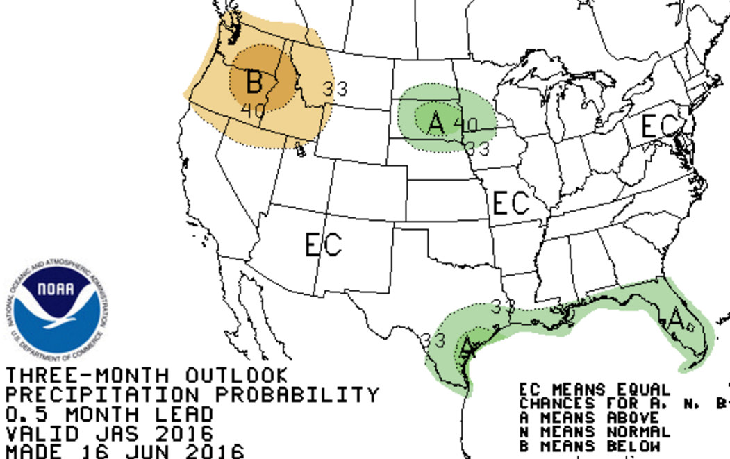
For the three-month period of July-August-September, the Climate Prediction Center is forecasting EC, or equal chances, of above/below/near normal conditions across Colorado. Not much to go on here either.
One way we can extrapolate past weather patterns towards predicting future weather is through analogs. Using this technique, we compare recent weather data (from the last few months) to the historical record. Based on our analysis, Boulder’s best analog years for 2016 (heading into the summer season) are 1998, 2010 and 1979.
Based on the top ten analogs, there is indication that this August could be drier than normal (70% chance). The analogs also tell us that September could be on the dry side as well (70% chance). However, Boulder’s analogs give no insight into July’s precipitation (top 10 analogs show equal chances of above normal, below normal, and normal precipitation).
Temperature:
Here is another box-and-whisker plot, but this time for mean monthly temperature.
Using the same assumptions about ENSO for the rest of summer as the last section, the box-and-whisker plots above tell us that the odds of all three months seeing below normal temperatures are elevated. Not overwhelmingly…just a tad.
Turning to our top 10 analogs again, but this time for temperature, we find a 70% chance that August would be colder than normal, and an 80% chance that September ends warmer than normal. July’s analogs contain no information.
The CFSv2 model is predicting slightly above normal temperatures for July, with near-average temperatures prevailing across Colorado in August and September.
Interestingly, the Climate Prediction Center is leaning towards greatly elevated chances of above normal temperatures for nearly the entire Continental United States.

Summary:
Based on everything we have detailed above, we summarize our thoughts below for the rest of the summer:
- ENSO neutral conditions will be in place through mid to late August, with a weak La Niña developing thereafter
- July will conclude with above normal temperatures and near normal precipitation
- For both August and September, we are predicting below normal precipitation
- September will be warmer than normal, possibly significantly so
- For the June/July/August period in general, we are forecasting above normal temperatures and below normal precipitation.
Our forecast doesn’t bode well for fire season across northern Colorado. Despite the seemingly constant threat of afternoon thunderstorms over the last several weeks, the higher elevations are drying out. This is also true for the northwest Denver suburbs…
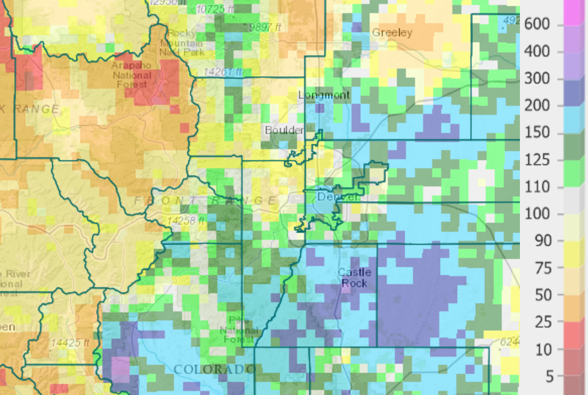
June 2016 total precipitation across the Front Range, given as a percentage of normal
Colorado is not in drought mode yet, but the first signs are there, especially if our “drier than normal” summer forecast verifies…
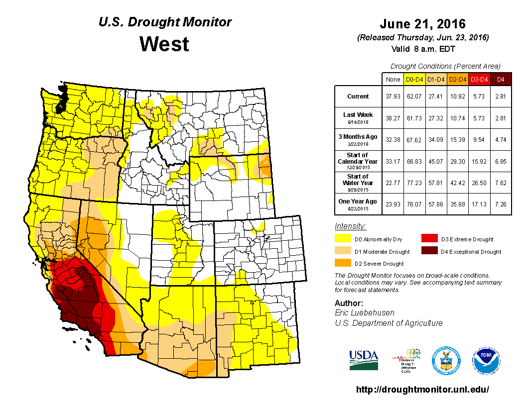
Though conditions aren’t dire yet, “abnormally dry” coverage is starting to form in Colorado’s northern mountains
It will be interesting to see how ENSO trends through the summer and fall. Lacking a strong El Niño in the Pacific, we suspect this year’s story will be much different than the last. We’ll be sure you keep to updated as things evolve though the latter half of 2016.