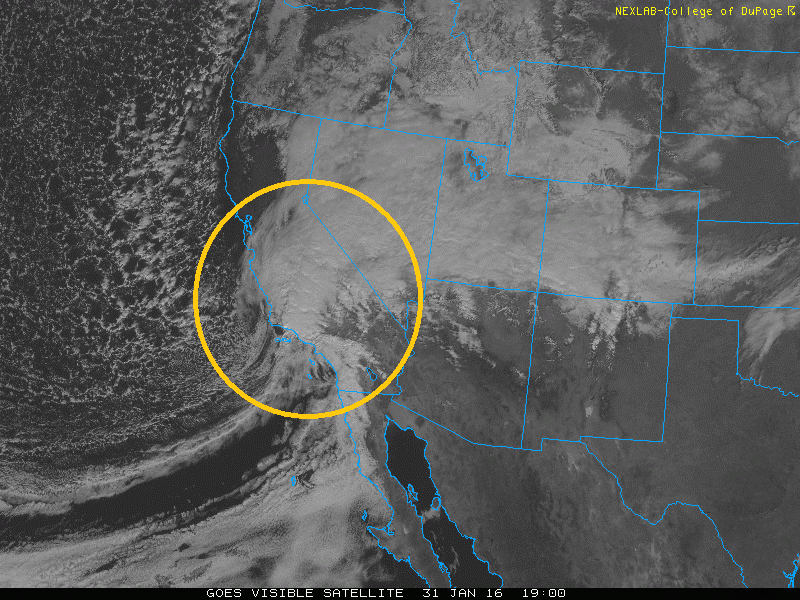
Storm system making landfall over southern California this afternoon
The strong winter storm is still right on track to hit the Denver Metro area and much of Colorado. As we discussed in our previous post, this storm looks impressive and will lead to several inches of snow on the ground by Tuesday morning. In this final update, we provide our snowfall forecast from tonight into Tuesday for Denver, Boulder and the adjacent Foothills.
As you can see in the above visible satellite image, the storm is still off to our west and is actually just making landfall across southern California this afternoon. This system will quickly move east-northeast into the Four Corners region tomorrow, then rapidly intensify tomorrow evening over southeastern Colorado.
We’ll see two main waves with this winter storm. If you have been following along with us, the storm is tracking just a little bit faster than prior estimations. The first wave develops later this afternoon / early evening and continues into early Monday morning. This wave is connected to a strong 140-knot jet streak extending from southern California northeast into Colorado. In the map below, we focus on the region in red, which indicates that we are under the left exit region of the jet streak tonight. This region is tied to upper-level divergence which will lead to a heavy band of snowfall tonight across our region (similar to the one last night). This first wave could produce several inches of snow by tomorrow morning’s commute.
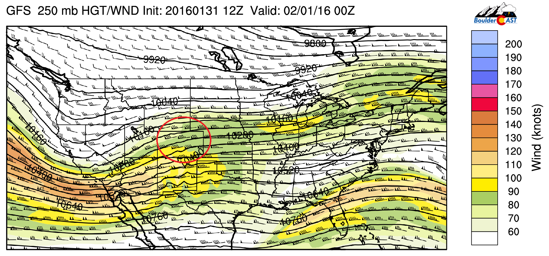
GFS 250 mb height and wind forecast for tonight
The second wave is stronger and lasts much longer, roughly a 24-hour period from tomorrow early afternoon into Tuesday morning. The aforementioned low pressure system tomorrow evening will move from the Four Corners area into southeastern Colorado. As it does so, the low will deepen and northeasterly upslope flow will strengthen. The upslope flow extends over a deep layer from the surface to roughly 600 mb in the atmosphere (roughly the height of Long’s Peak!). There are some differences still in the models, with the GFS depicting the surface low further north than the NAM, as you can see below, but the differences will not significantly affect the overall outcome for snow.
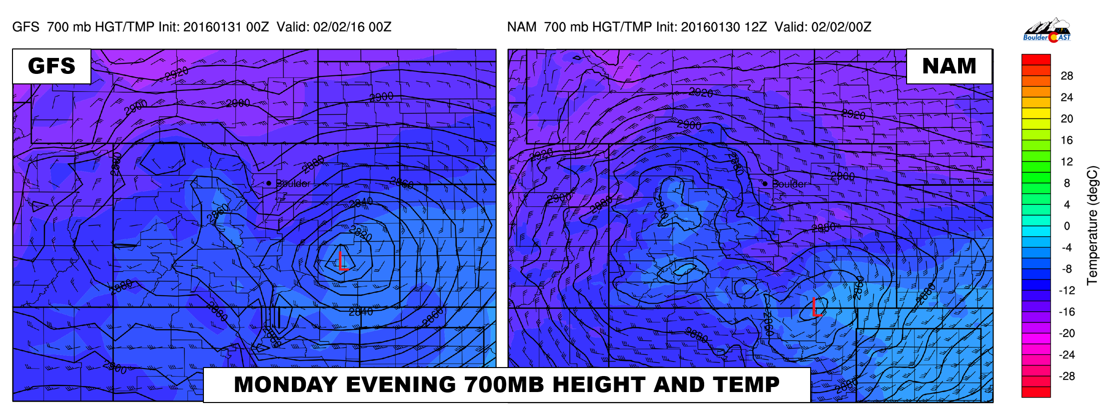
700mb height and temperature map for Monday evening from the GFS (left) and NAM (right) models.
We see several factors working in our favor for a good snow event across Boulder and the Denver Metro. We will list them off before going into our official forecast!
- A long duration event with moderate, to at times, heavy snow, beginning tonight and continuing to Tuesday morning. This is tied to a deep layer of northeasterly upslope flow and some jet interaction (mostly tonight)
- The snow growth region is co-located with a region of lift due to the upslope flow. Below shows the NAM grid point forecast for Boulder. Highlighted in the white box region is the forecast time period from tonight to Tuesday morning. The circled regions in pink and yellow denote the region of snow growth, with the red contour lines denoting upward motion or lift in the atmosphere. The y-axis on the right denotes the pressure levels. As you can see, the NAM forecasts a region of lift in the same region where dendritic snow crystals will be forming (pink overlapping yellow). This will help to enhance snowfall rates.
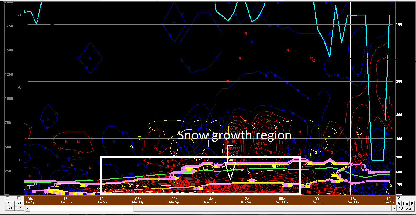
NAM Bufkit sounding forecast for Boulder
4. Snow-to-liquid ratios (SLRs) of greater than 15:1. With 700 mb temperatures around -16 Celsius above during the event, this will lead to high snow-to-liquid ratios and high snow totals. The NAM is indicating 15-20 SLR during the storm.
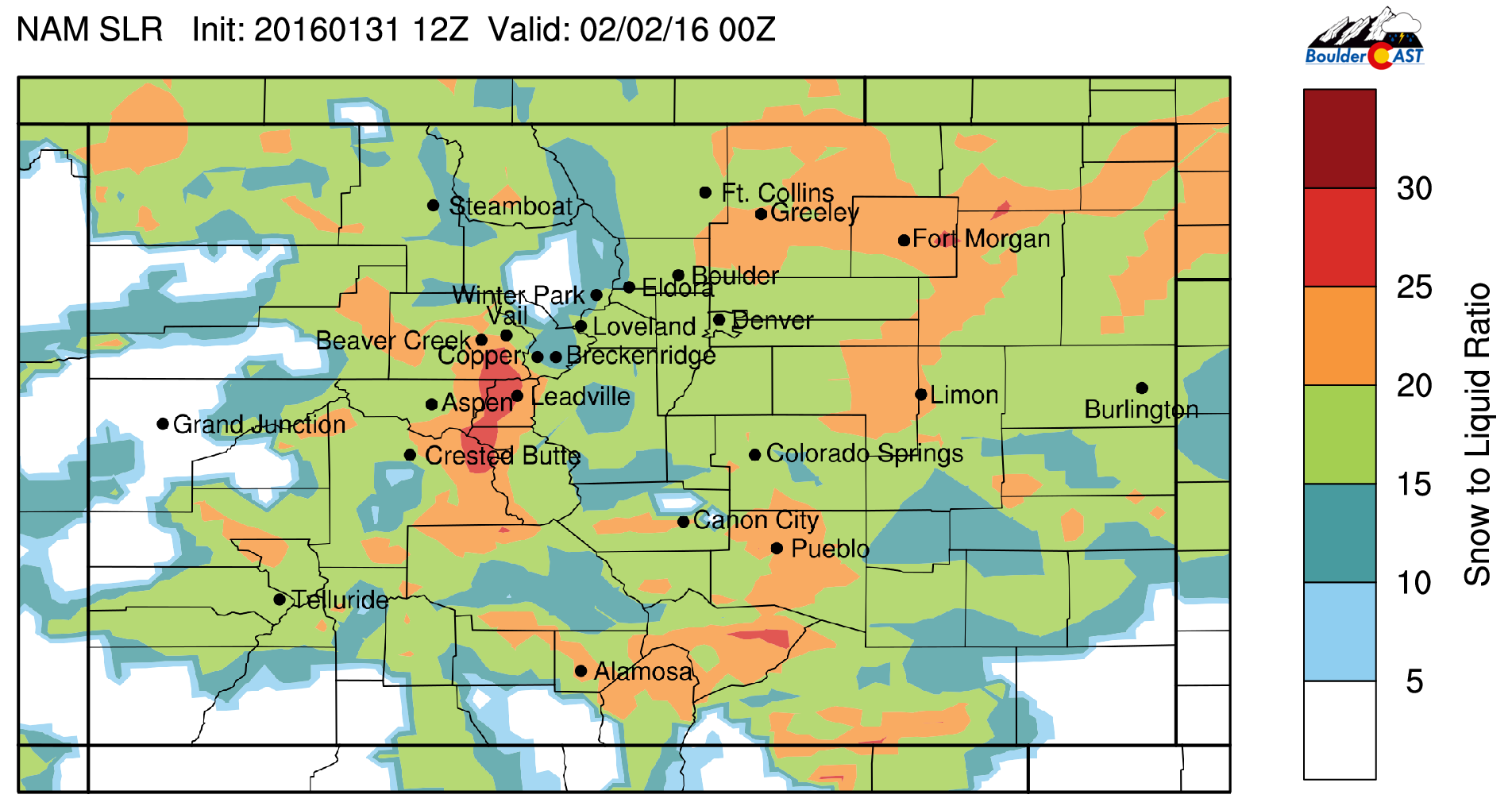
NAM snow to liquid ratio during the storm
One downside to the storm is that there does not appear to be a large fetch of Gulf of Mexico moisture up into Colorado. The National Weather Service in Boulder discussed this in their prior forecast discussions. Due to this, the amount of moisture is not as impressive as with other systems. However, given the long duration of upslope flow, the lack of moisture is not all the concerning!
Finally, models have come into great agreement as to the precipitation, with the ensemble forecast models of the GEFS and SREF converging around 1″ of liquid when all is said and done, which equates to 10 to 15 inches of snow over Boulder with a 15:1 snow ratio.
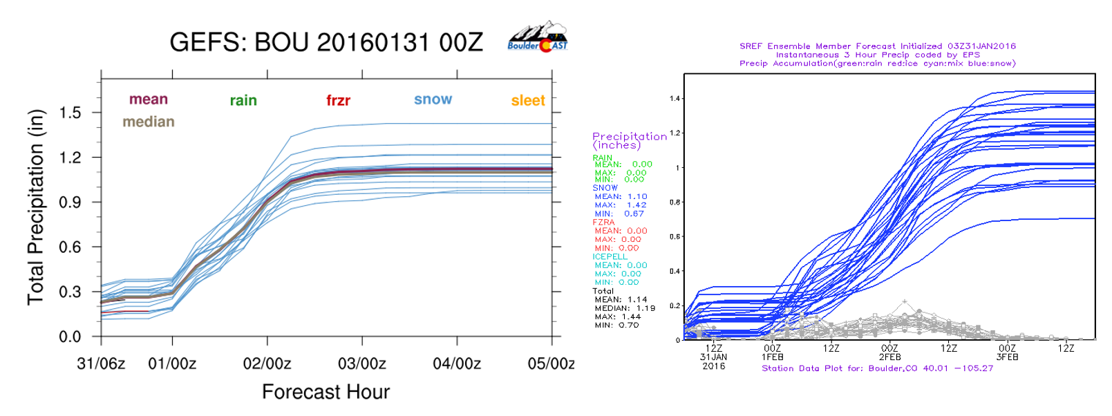
Ensemble forecast liquid precipitation from the GEFS (left) and SREF (right), indicating about 1″ of liquid precipitation for the event.

NAM total snowfall ending Tuesday afternoon, showing 10-12 inches in Boulder
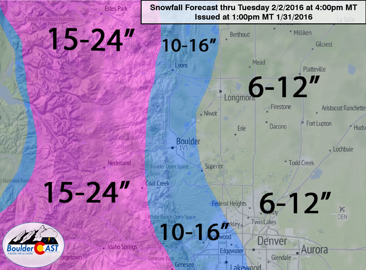
Our official forecast calls for:
- 10-16″ for Boulder, and the immediate area to where the Plains meet the Foothills
- 15-24″ in the Foothills
- 6-12″ across the rest of the Denver Metro area
- 10-20″ for the Palmer Divide
Here is a graphical representation of our forecast.
This will be a long duration, high-impact event! As such, we will be activating the first ever BoulderCAST Live Blog later this evening. Please join us as we track the evolving storm and it’s impacts across the area. You will find the Live Blog post at the top of our homepage (when it is active).
Be sure to take it easy on the roads these next few days and allow more time to get to your destination. Happy snow and enjoy some sledding!


