Another spring storm will be impacting the entire state of Colorado Sunday afternoon into Monday. For the Front Range, the forecast over the next 24 hours includes thunderstorms, soaking rain, and accumulating snow. Read on to find out when we expect rain to change-over in your location and for our snowfall forecast map with potential amounts.
As we get into the latter part of March, the atmosphere really starts to moisten up again, increasing the potential for bigger snow events. However, with that moisture comes higher sun angles and warmer temperatures overall. It’s a bit of a “Catch 22” for snowfall across our region. This facet always makes forecasting snow in Boulder and Denver a challenge this time of year. As you may have guessed, the main issue with today’s storm is going to be temperatures and when the rain will change to snow across the lower elevations. We’ll come back to this in a moment….
Not much has changed with this storm system in the weather models since our last forecast update on Friday. As of this morning, a small but strong upper-level low pressure is located near the Four Corners region. Through the day, it will be moving across northern New Mexico. This is more-or-less on track with where models had the storm a few days ago, if not just a hair further south. This track will put most of our state in a favorable location for precipitation through the day into the overnight hours.
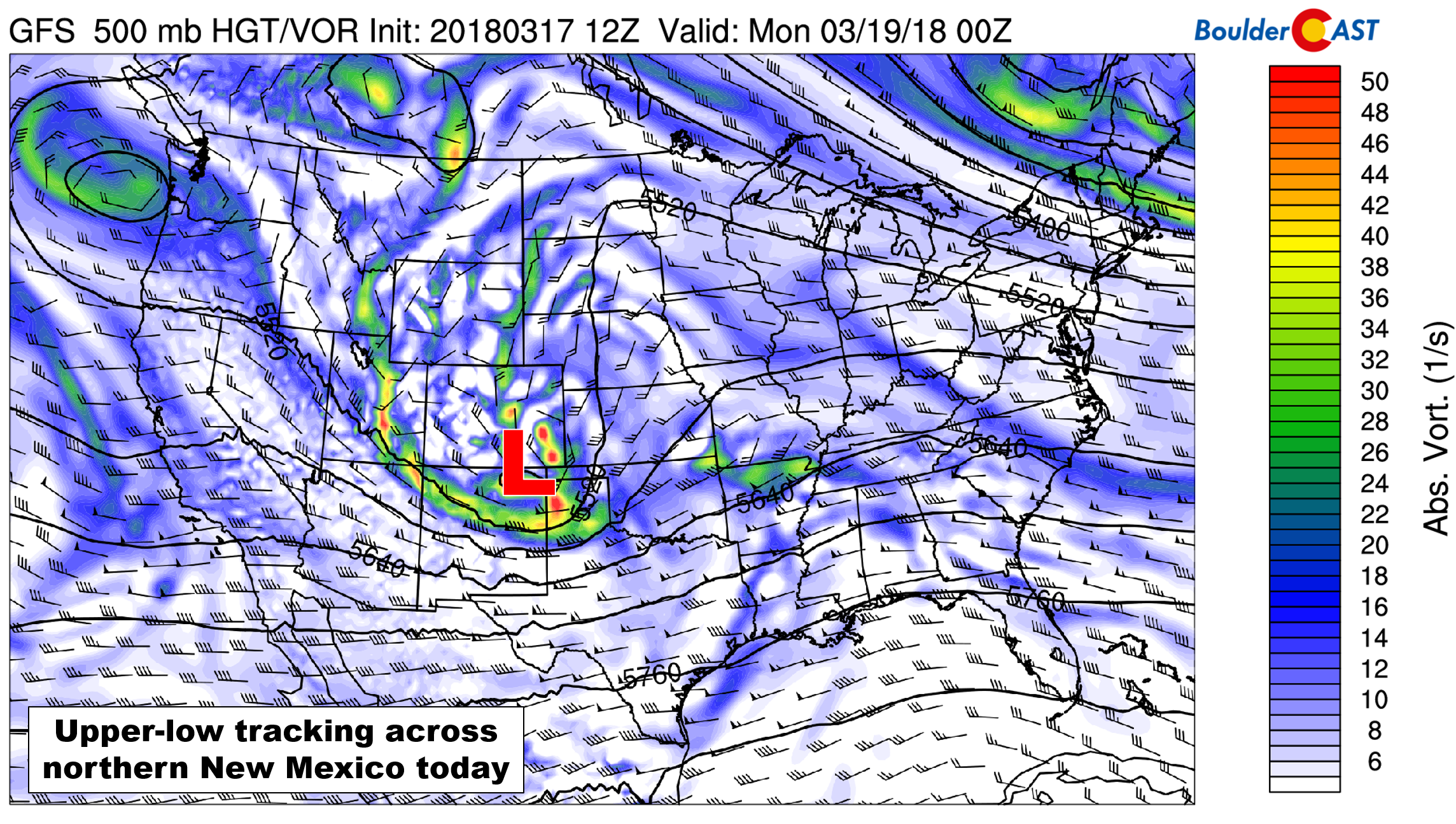
GFS 500 mb vorticity map for Sunday evening. The storm will be tracking across northern New Mexico.
Before the precipitation arrives, it will seem like a lovely spring day out there. We expect high temperatures across the Plains to push into the low to middle 50’s by early afternoon. Solar heating and upper-level forcing will combine to spawn convective precipitation across the Mountains, eventually pushing eastward across the Plains by late afternoon and early evening. Models are indicating even more CAPE than with last Thursday’s storm, up to 400 J/kg across the region. This means a better chance of thunderstorms this time around. Still we expect any rumbles of thunder to be fairly isolated.
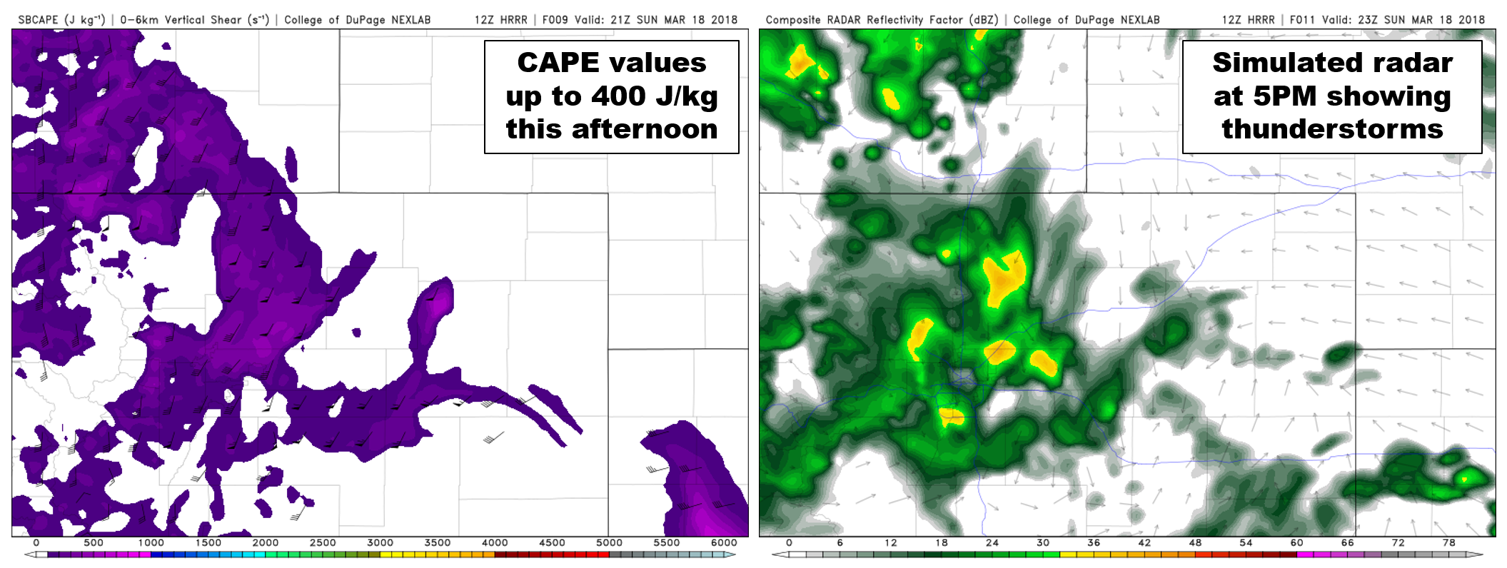
HRRR CAPE forecast (left) and simulated radar (right) for Sunday early evening. A few thunderstorms could form across the Metro area.
With temperatures in the 50’s on the Plains, the precipitation will definitely start as rain. This includes much of the Foothills as well. Snow levels begin around 9,000 feet at mid-day. A surface low developing in southeast Colorado will help funnel in colder air from the north to the Metro area by early evening, with snow levels falling down to 6,000 feet around sunset.

NAM-derived snow level forecast timeline for the storm.
For the Plains, that last bit of cooling needed to change rain to snow is going to be very tricky, especially for the northern part of the Metro area. This is due to low-level northerly winds that are expected with this storm. Without any significant easterly component to the flow, this northerly direction will produce downslope into the Metro area from the Cheyenne Ridge. This is the first time so far this winter we have had to deal with this facet of Front Range topography. If you were a reader last year, you should be very familiar….
Though the downslope warming effect from the Cheyenne Ridge is normally negligible, those 1 to 3 degrees of warming are magnified when moderate precipitation is falling with temperatures in the middle 30’s. This will be the scenario later this evening. With the convective nature of the rain and snow, a slight shift either way in change-over time could lead to big impacts on the forecast.
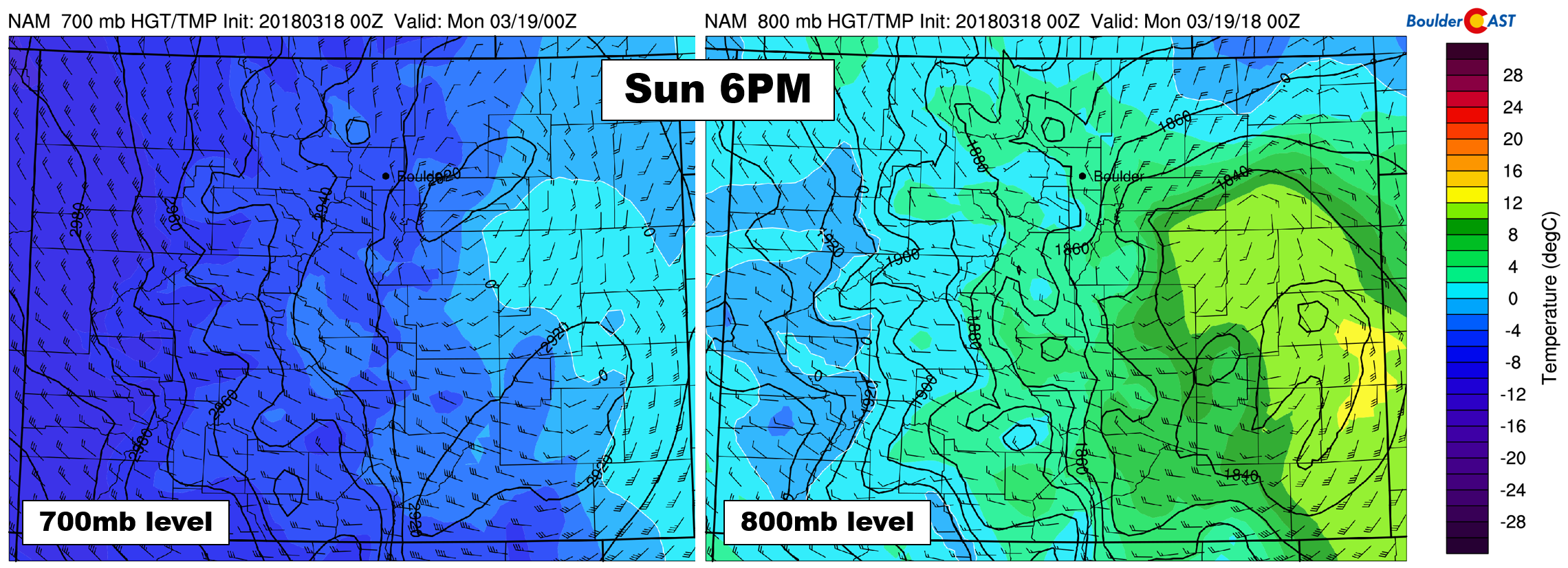
NAM 700 mb (left) and 800 mb (right) temperature and wind forecast for Sunday evening. Notice the lack of upslope across the Foothills and Boulder area.
With that cautionary statement out of the way, here’s what we are thinking for everyone….
Mountains
The “easiest” forecast today is for the Mountains above 9,500 feet where all precipitation will fall in the form of snow. Expect widespread snow showers with embedded thundersnow through the afternoon and early evening. Snowfall rates within heavier storm cells could easily top 3″ per hour.
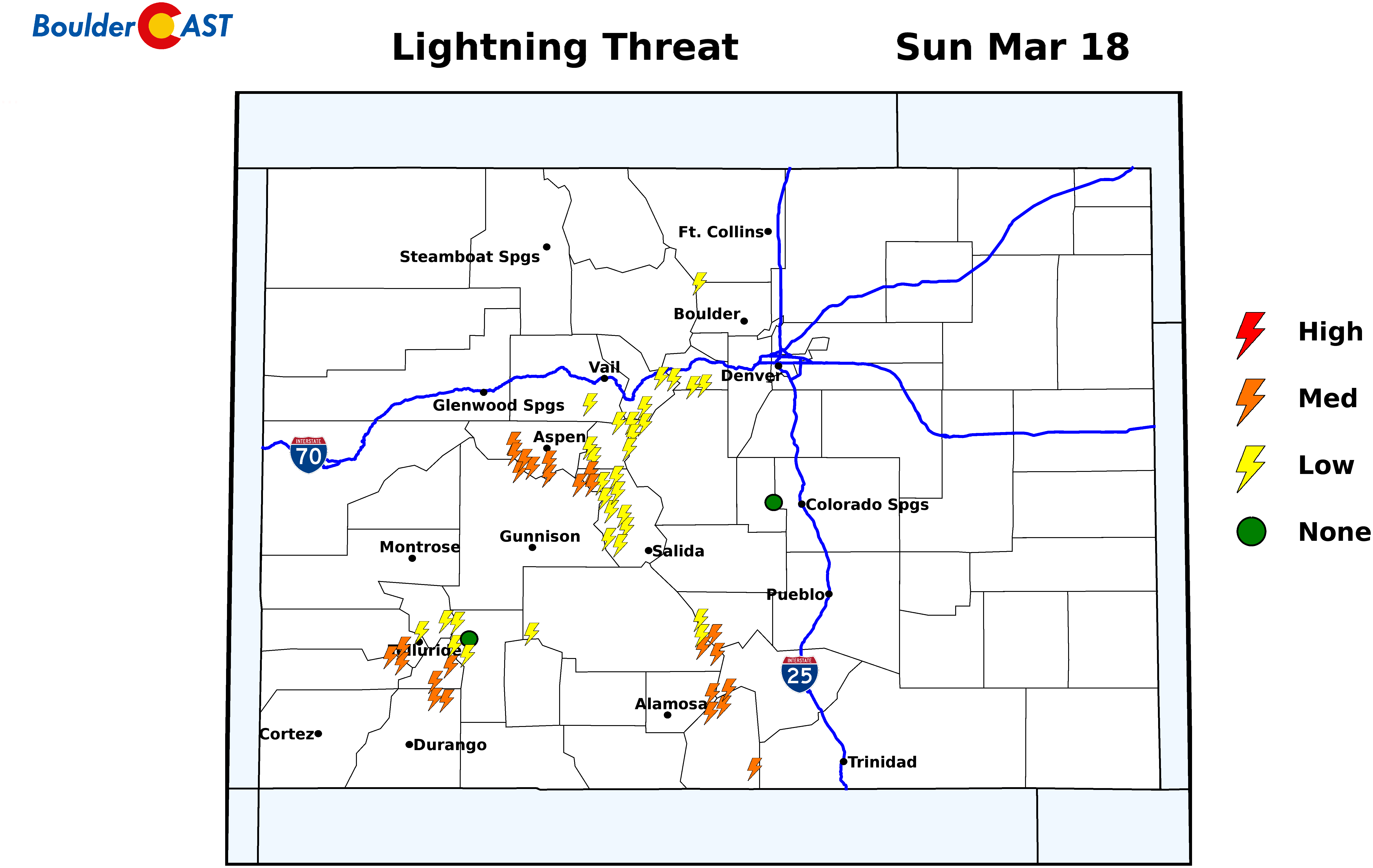
Lightning threat for Sunday afternoon across the state from SummitCAST.
Due the convective nature of the snow during the day, snow amounts could be highly variable from location to location. However, there is a fair amount of westerly topographic lift through the evening which should even things out post-convection. We’re forecasting 6-12″ for most areas statewide. Monday will be an excellent ski day if you are so inclined…
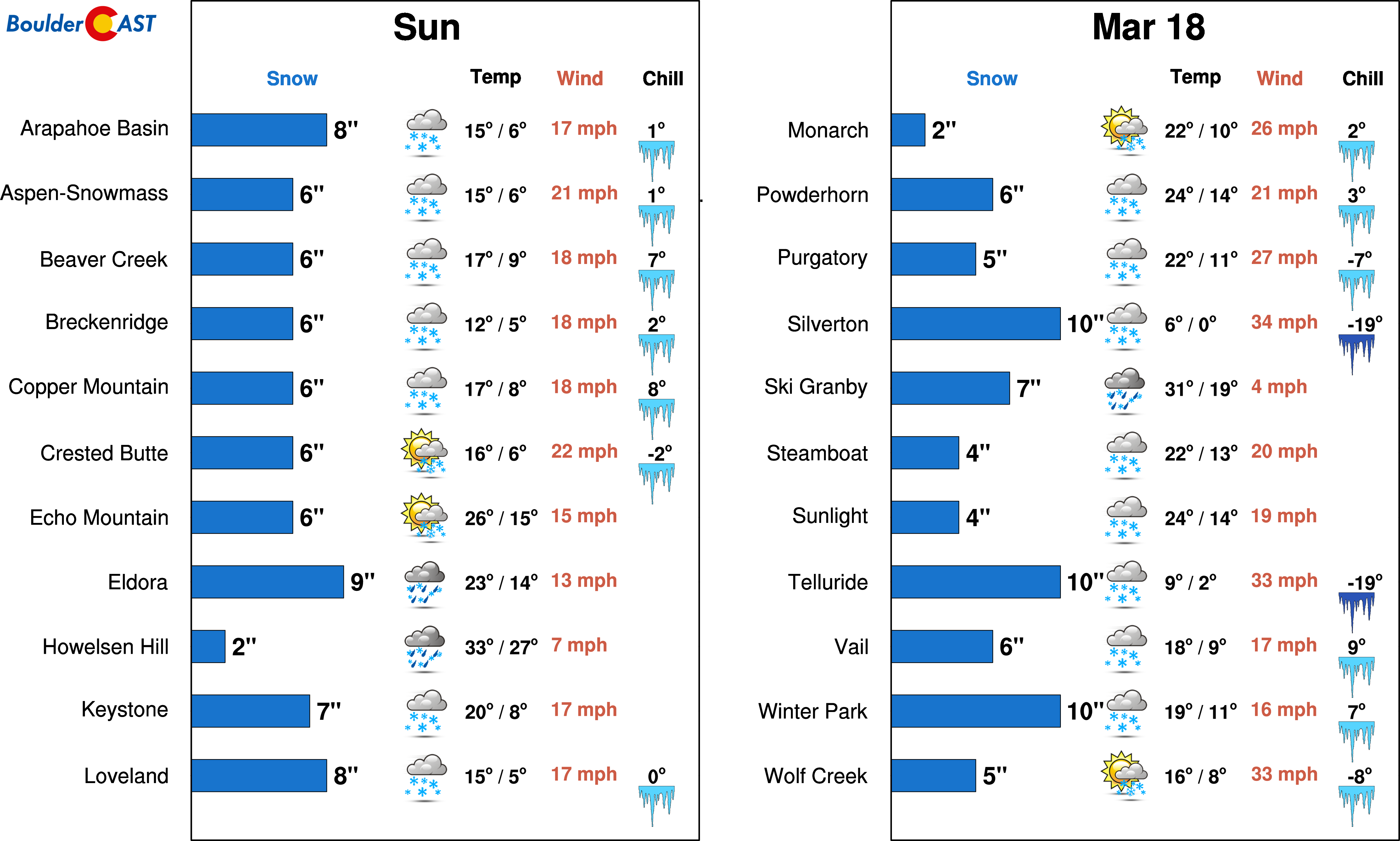
PowderCAST snowfall forecast for the ski resorts on Sunday.
Foothills
We are less confident in the forecast for the Foothills given the lack of extended upslope which will likely keep this event from being a major one. Snow levels will be falling from 9,000 feet around mid-day to around 6,000 feet by sunset. Considering the earlier change-over in the higher Foothills, we expect larger snow accumulations there. With thundersnow on the table, amounts could also be highly variable here as well.
Our forecast calls for 3-7″ in the higher Foothills above 7,500 feet. In the areas between 6,000 feet and 7,500 feet, 1-4″ can be expected. Yes, temperatures will be cold enough for snow here, but the lack of upslope is concerning to us and could cause a bust lower than forecast.
Plains
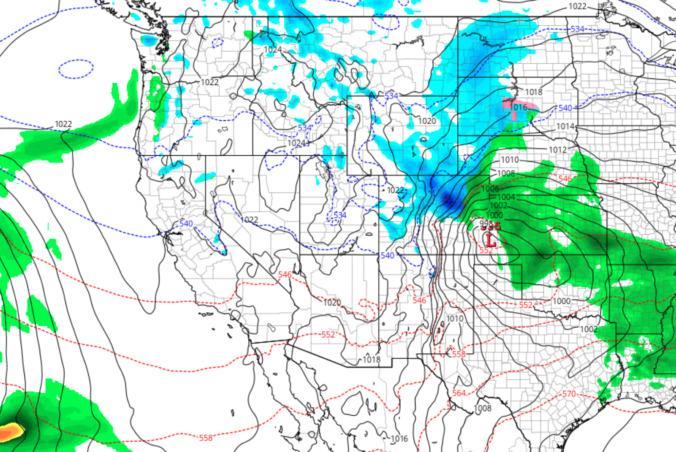
The GFS continues to produce a swath of 0.5 to 1.2″ of precipitation across the Front Range. This is higher than any other models right now. Blending the model solutions, we believe totals will be lower but still hefty, from 0.3 to 0.8″ of liquid.
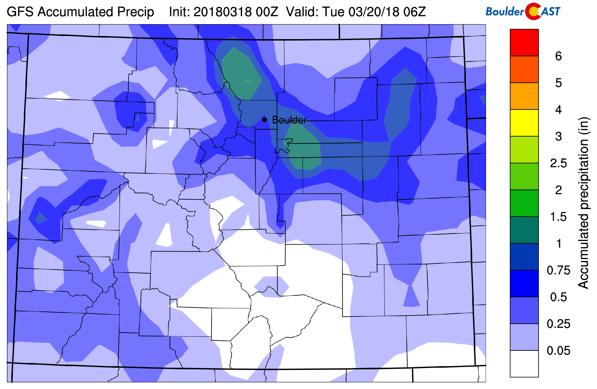
GFS total liquid precipitation for the storm. We believe the overall pattern is correct, but amounts will be less than this.
There is good model agreement right now that the change-over time for the lower elevations will be sometime between 5:00PM and 9:00PM, with the northwest Metro area potentially remaining rain a little longer. This includes Boulder, Longmont, and Loveland. However, considering the intensity of the expected rainfall, any slight shift in timing will lead to periods of heavy snowfall across the lower elevations…2″ of snow per hour. This early change-over seems more likely in southern Denver where those gusty northerly winds will be upslope into the Palmer Divide adding additional cooling. Patchy light snow will linger into the early morning hours, winding down before sunrise Monday morning.
HRRR precip type and intensity forecast through 1:00 AM Sunday night.
We’re going with 1-4″ in southern Denver, with lower amounts towards Boulder where we believe rain will linger a few hours longer. Our forecast map for the region is shown below.
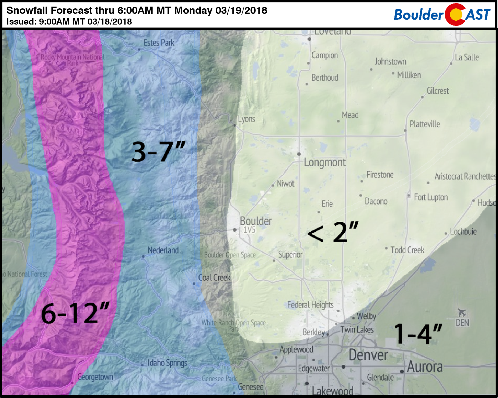
Needless to say, our overall confidence in snow amounts is low across the Plains and parts of the Foothills. Don’t be surprised by bursts of heavy snow this evening with limited visibility. Despite the warm weather of late and this morning, convective snow won’t have any trouble accumulating on the roadways, so do be careful later this evening if you are traveling. Gusty northerly winds overnight to 35 mph will make travel even more challenging in areas that do see snow.
The storm pulls eastward tomorrow with temperatures remaining below normal in the 40’s. Skies will be mostly cloudy. The upcoming work-week looks like a dry and mild one for the lower elevations. We are tracking a few rounds of snow for the Mountains, though. More on this in our weekly outlook tomorrow.
If you’re lucky enough to get a few inches of snow tonight, do enjoy it!
Share our forecast:
.


