
A moisture-infused spring storm dumped up to 2″ of liquid and 2 feet of wet snow in portions of the Metro area on Thursday on the first day of spring. We briefly review the atmospheric setup and take a look at the regional snow totals and blizzard-inducing wind gusts.
Storm Recap Highlights:
- A strong, moisture-infused spring storm blanketed the Front Range with wet snow on Thursday
- Accompanying the storm was a pipeline of subtropical moisture which made yesterday one of the “moistest” days in Denver’s history
- Snow totals ranged from 3 to 10 inches across the lower elevations, with up to two feet in the Foothills west of Boulder
- Blizzard conditions were reported north and east of Denver, but blowing snow was manageable in our immediate area
- With about six weeks to go in snow season, Boulder has reached 112 inches already
Help support our team of Front Range forecasters by joining BoulderCAST Premium. We talk Boulder and Denver weather every single day. Sign up now to get access to our daily forecast discussions each morning, complete six-day skiing and hiking forecasts powered by machine learning, first-class access to all our Colorado-centric high-resolution weather graphics, bonus storm updates and much more! Or not, we just appreciate your readership!
*SPRING SALE* Until March 20th, use the promo code SPRING to save 25% on BoulderCAST Premium.

W
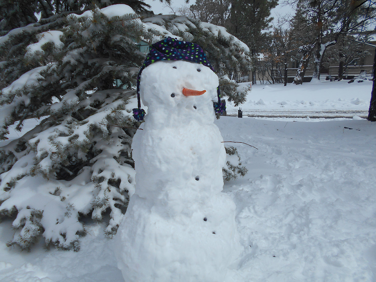
hile Thursday’s snowstorm may not have been the biggest so far this winter in terms of raw snowfall production (that honor goes to the historic storm that unfolded back around Thanksgiving), it certainly was the wettest! If you ventured out into the cold and snow, you probably realized quickly that it was excellent for engineering a snow man, but not so much for shoveling!
The storm system responsible dug a track very far south into Mexico on Tuesday before making a turn back northward and across Colorado. Watch the low pressure evolve and approach in the GOES-East water vapor satellite animation below. The pipeline of subtropical moisture spiraling all the way around the system and back into northern Colorado during the day Thursday was remarkable. The weather balloon that launched Thursday morning in Denver measured a total atmospheric moisture content of 0.52″, the second highest value ever for the date. Moisture was of no shortage on Thursday!
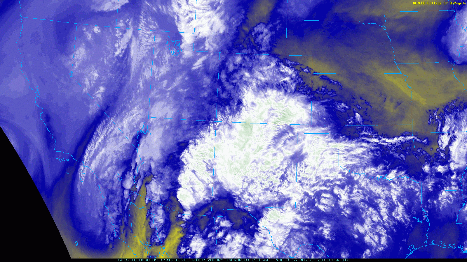
GOES-East water vapor animation from Wednesday evening into Thursday night.
The deep moisture traveled along what is called a warm conveyor belt which can wrap into the core of the storm along the northern tier. Both forecast graphics below, precipitable water on the left and 700mb equivalent potential temperature on the right, help visualize the warm and moist conveyor belt setup on Thursday.

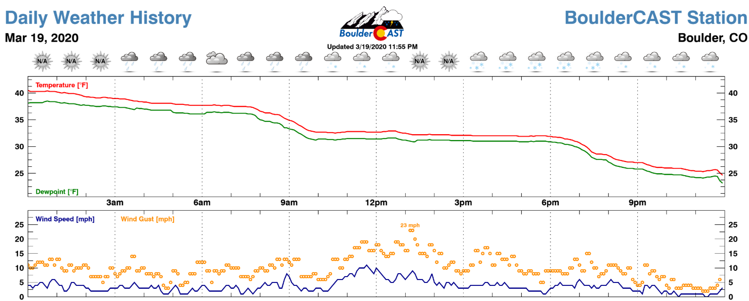
As the best lift, moisture and upslope aligned Thursday morning, widespread rainfall broke out around sunrise and transitioned to heavy snow within a few hours in most locations. The change-over was maybe an hour or two ahead of schedule, but really there were no surprises with this storm. Moderate to heavy snow continued through much of the day and accumulated surprisingly well, though there was a lot of melting taking place with slush and small streams forming along roadways.
As for snow amounts, they were just as impressive as expected! Interpolated snowfall observations from the event are shown below for the broader region (top) and Front Range (bottom). The heaviest snow was indeed aligned with our forecast and was found in the Foothills above 7500 feet where 1 to 2 feet of wet snow fell.


Shown below is our snowfall forecast map issued Wednesday afternoon with actual storm totals overlaid in boxes. Green boxes indicate that our forecast verified to within one inch of the observed snowfall. Red did not.

As you can see, our snowfall forecast had good verification across most of the Front Range, though there were a few boomers in the Foothills. The highest total reported was just east of Nederland in Boulder County near 8400 feet elevation (thanks for your report, Barb!). The official totals were 8.1″ in Boulder and 6.0″ in Denver. The storm has bolstered our already above average seasonal snowfall totals:
| Seasonal Snow Totals (Updated March 20 2020) |
|---|
| Boulder | Denver |
|---|---|
| 112.0" | 52.9" |
That 112″ so far in Boulder makes the 2019-2020 winter Boulder’s 14th snowiest season since the late 1800’s, and we’ve still got a solid 6 to 10 weeks of possible snow to go.
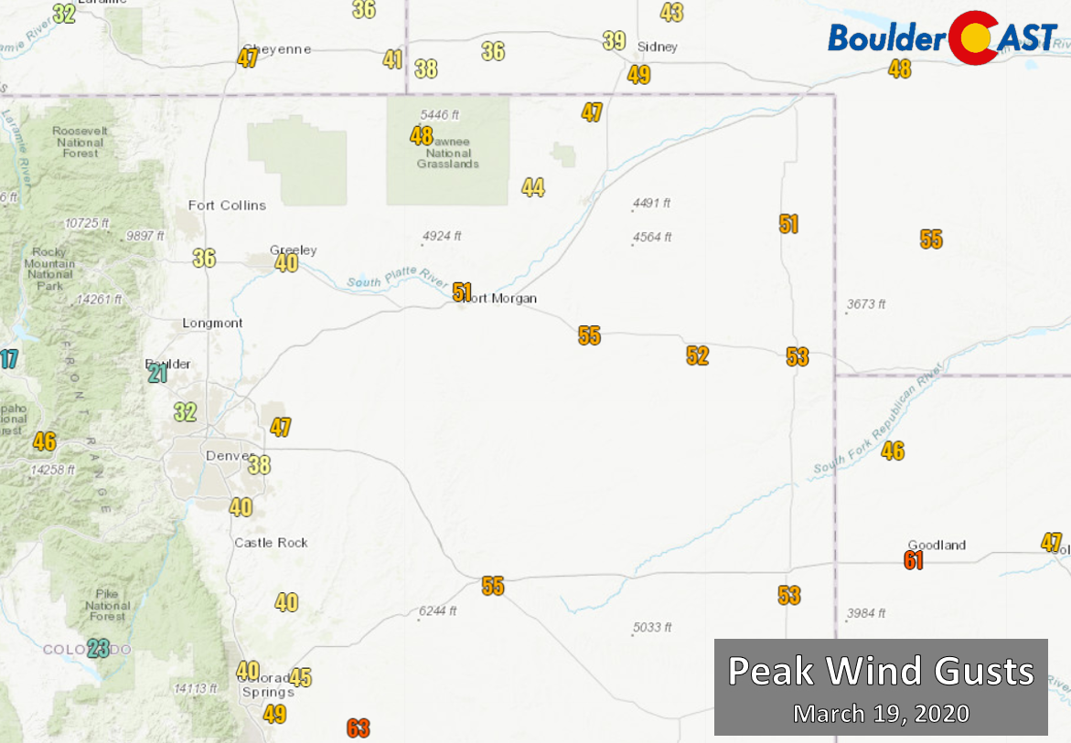
Finally, we wanted to touch on the strong north winds that occurred east and northeast of the Denver Metro area on Thursday where Blizzard Warnings were in effect. Wind gusts generally only topped out between 25 and 40 MPH is the immediate Denver Metro area. Given the high moisture content of the wet snow, blowing and drifting wasn’t too bad overall in our area. We lucked out a little on this front. However, heading east on the Plains, gusts reached up to 55 MPH and blizzard conditions were reported.
Another round of much more scattered snow showers will impact the Front Range Friday afternoon and evening. For Denver and especially Boulder, a trace to 1″ of snow at most is expected with these brief and spotty convective snow showers rolling off the higher terrain. Up to 3″ could fall in the Foothills, however. Beyond this, the weather pattern for Colorado will remain active into the upcoming week with several additional chances of snow for us. None of them look too promising at the moment, but that’s not to say something won’t pique our interest in the coming days.
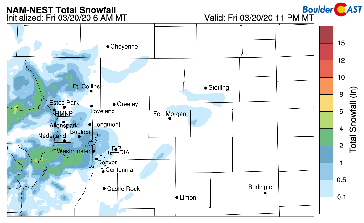
NAM-NEST model-derived snowfall forecast through Friday evening
Between the rain and the snow that dumped with Thursday’s storm, just about everywhere in the Metro area received 1 to 2″ of moisture. What a way to kick-off the spring season! With warming temperatures in the coming weeks, the hillsides will certainly be turning green in no time!
.
Share Colorado’s crazy weather, share this post:


You must be logged in to post a comment.