Our low-confidence snowfall forecast ended up turning out okay in most areas on Wednesday. This is despite a huge convective snow squall throwing a wrench into things late in the afternoon. Read on as we discuss what happened and review the totals from the snowfall event, which by the way was our fifth in just the last ten days.
T
hings appeared to be going just as planned early Wednesday afternoon when moderate bands of snowfall began to develop in and near the Foothills of Boulder and Jefferson Counties, just as the high-resolution models were showing and our forecast called for. However, this changed in short order as a massive convective cell of heavy snow developed in Weld County. This cell prompted a Snow Squall Warning for the area near Greeley due to extremely heavy snowfall rates and gusty winds. Travel within this cell would have been nearly impossible. A Snow Squall Warning is indeed the wintertime equivalent to the more formidable Severe Thunderstorm Warning.
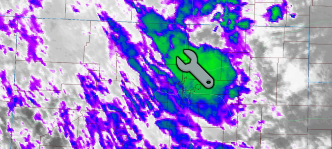
The GOES-East infrared satellite animation below shows the developing cell Wednesday afternoon. The bright green colors indicate very cold cloud tops. Very cold clouds are very high (tall) clouds, which speaks to the convective nature of this cell and also the instability/lift in the atmosphere at this time…impressive for mid-February.
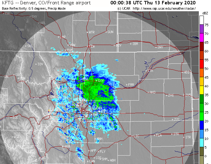
The radar returns from this squall were equally as impressive. At times reflectivities exceeded 35 dBZ…roughly 2 to 3″ per hour snowfall rates. The storm looked so prominent on radar, we had to check if it was producing any lightning strikes (it did not)!
As a consequence of this potent cell forming, the influx of low-level moist air killed off all of the surrounding convection. It even pulled in some drier downslope flow to most of the Denver Metro area, including Boulder.
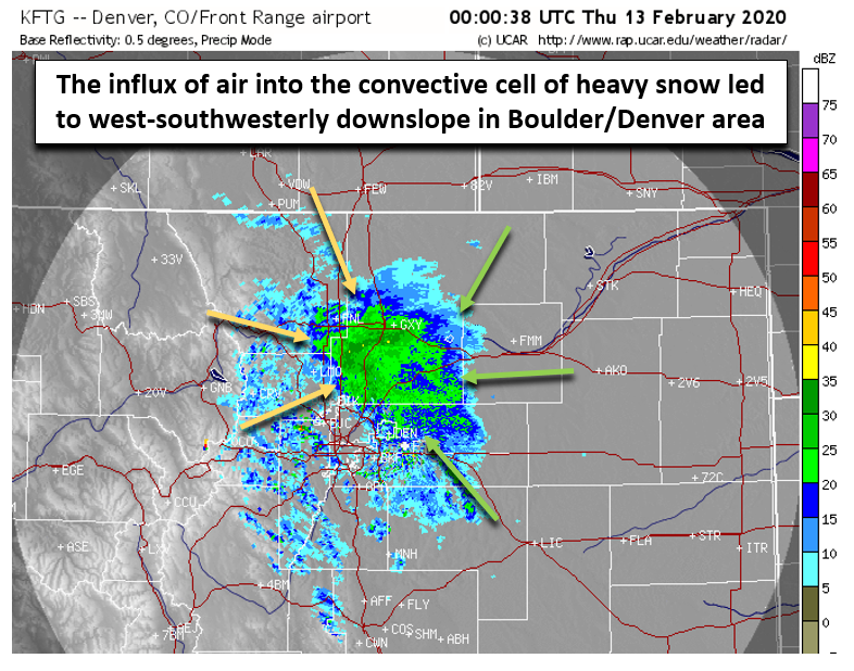
This shift to downslope is visible clear as day in the wind observations from BoulderCAST Station (shown below). Note the precise change to west-southwesterly winds during the time the convective snow squall was roaring in Greeley (see below). As soon as the cell began to dissipate, winds returned to a more favorable northeast upslope direction.

This wind shift caused a lengthy lull in the snow for Boulder and Denver, something we thought might be too difficult to recover from. For some areas of southwest Denver, it definitely was. However, the return to upslope happened quickly enough that most areas ended up seeing several hours of additional light to occasional moderate snowfall before things wrapped up abruptly around midnight.
We should also note that convection itself was not unexpected and was very much a part of our forecast. Considering the notable cold air aloft moving in Wednesday afternoon and the lift from the left-exit region of the overhead jet, it was a certainty we would see some convective cells of heavy snow mixed in with the otherwise light upslope snow during this event. The wrench was more in the location. No weather models were showing anything happening in Weld County. This was almost an impossible forecast to make, in our opinion.
Shown below is our snowfall forecast map issued early Wednesday morning with actual storm totals overlaid in boxes. Green boxes indicate that our forecast verified to within one inch of the observed snowfall. Red did not.

Our snowfall forecast ended up verifying quite well in most locations across the Metro area, though clearly the convective cell near Greeley caused some issues. The area we expected to get hit hardest, the Foothills of Jefferson County, was largely spared. The far northeast Plains where we expected the least snow, received the most. There’s not a lot of observations from this more rural area, but considering how long the cell of heavy snow lingered between DIA and Greeley, it’s likely there are some localized 8-10″ totals that have gone unreported! The highest snowfall reports we found from Wednesday evening came out of Brighton (6.0″) and DIA (5.0″). A bulk of the Boulder-Denver Metro area reported totals from 1 to 3″.
OFFICIAL SNOW TOTALS
Boulder: 2.6″ (2 – 6″ forecast)
Denver: 5.0″ (1 – 3″ forecast)
Storm Original Forecast
| Seasonal Snow Totals (as of Feb 13 2020) |
|---|
| Boulder | Denver |
|---|---|
| 91.8" | 40.4" |
For the season, Boulder continues to more than “double-up” Denver in snow. As we covered in a post a few days ago, Boulder has already blown passed what typically falls in an entire winter. With some of our climatologically snowiest times still to come, we could be looking at a winter for the record books! After a string of quiet days ahead, our next chance of accumulating snow is already taking shape for late in the weekend or Presidents Day on Monday! Have a good end to the week and weekend. You’ll probably be hearing from us sooner than you want to…
We discuss Boulder and Denver weather every single day on BoulderCAST Premium. Sign up today to get access to our daily forecast discussions every morning, complete six-day skiing and hiking forecasts powered by machine learning, access to all our Front Range specific weather models, additional storm updates and much more!

.
Share Colorado weather, share this post:
.


You must be logged in to post a comment.