A potent southern-track storm system will scoot across southern Colorado on Sunday bringing the return of winter weather to the Front Range. While warmer temperatures will limit the overall impact, we are expecting a small amount of accumulating snow for much of the Denver Metro area. Read our latest forecast and see where your location lands on our snowfall forecast map.
T
he cut-off low pressure system that has been sitting off the coast of California since Wednesday is finally coming ashore as of Saturday afternoon. The storm can be seen spinning near Los Angeles on GOES-East water vapor imagery. This animation also shows the plume of subtropical moisture streaming into Colorado already ahead of the system. Take a look outside: the upper-level clouds are already on the increase in our area!
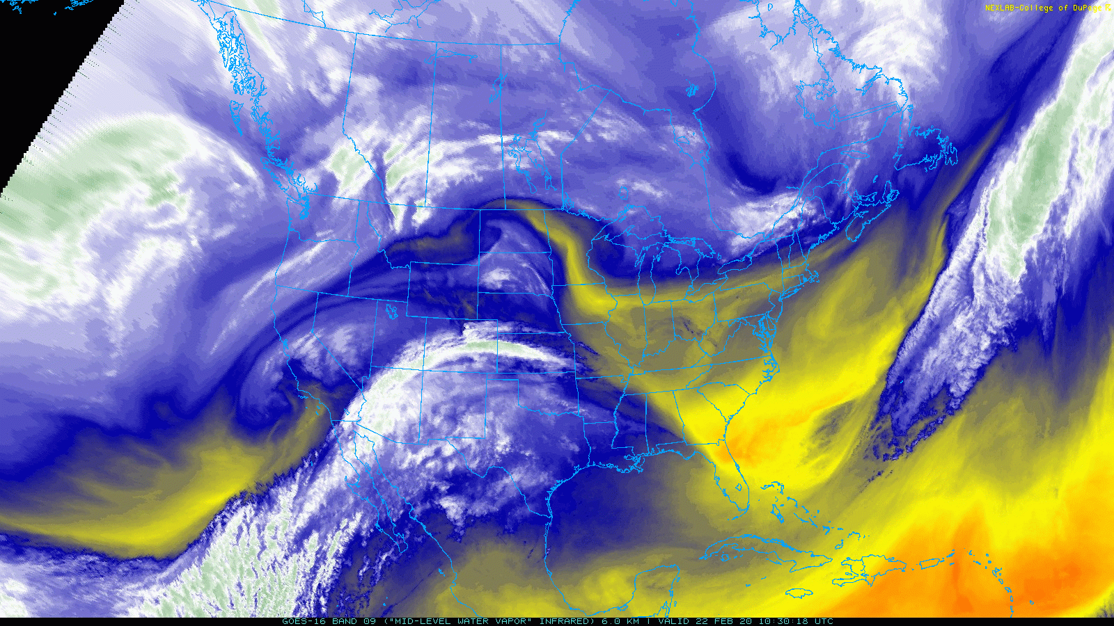
GOES-East water vapor satellite animation from Saturday morning and afternoon
We’ve been tracking this storm for several days now and the entire time our team has remained cautious about the exact impacts it would have on Front Range Colorado whenever it eventually moved eastward. Track is everything! Well… that day is today and we’ve seen models trend a bit further south with the storm’s track. The center of the low is expected to move into the Four Corners region Saturday night and then quickly along the Colorado/New Mexico border during the day Sunday. This is about 100 miles further south than it looked a few days ago.
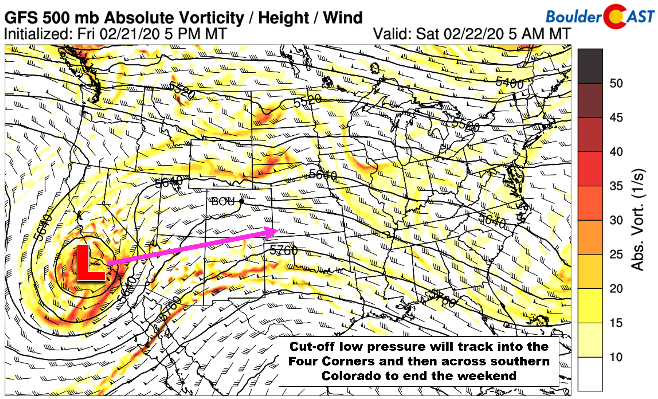
GFS 500 mb vorticity forecast map valid Saturday morning
Unfortunately, despite the good energy and abundance of moisture this storm has with it, the quick movement and southern track are not favorable for much snow in our area. With the low tracking through extreme southern Colorado, the best moisture and upslope will be focused further south across the Colorado Springs and Pueblo areas (see below). Nonetheless, we do still expect some weak but deep easterly flow across the Denver Metro area Sunday morning into the afternoon. HOWEVER, latest indication is that this easterly flow will primarily be southeasterly. Southeasterly winds are not very favorable for our area either as there is some downslope component in the low levels off the Palmer Divide.
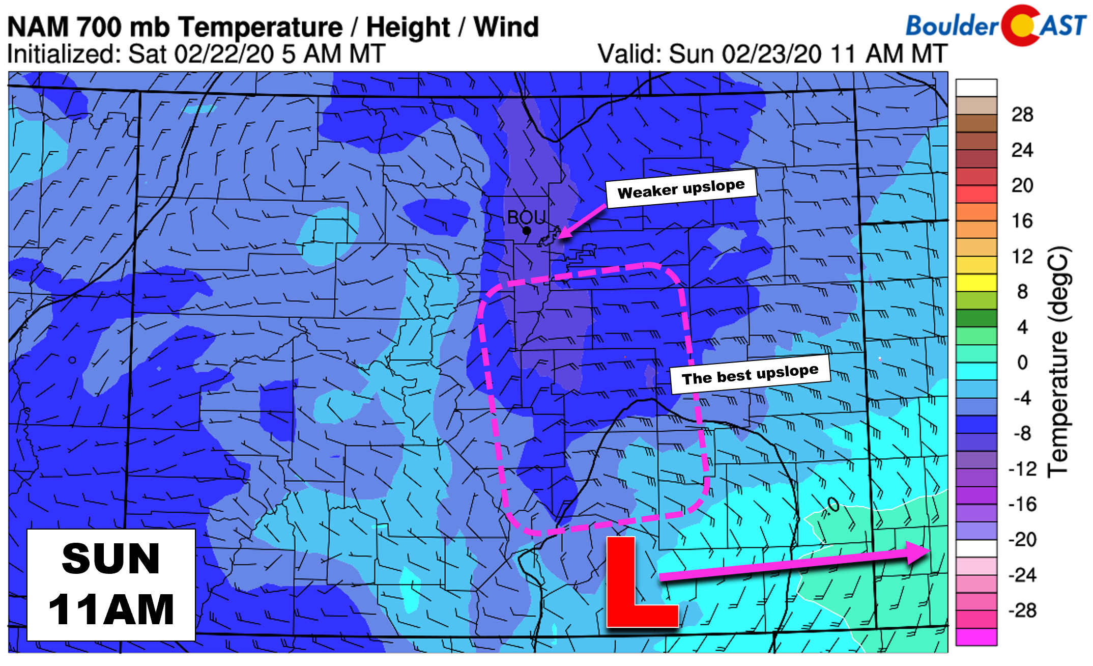
NAM 700 mb temperature and wind forecast for Sunday late morning. The best upslope resides south of the area
We’ve barely had to worry about temperatures mixing snow with rain this winter, mostly because the handful of storms that impacted us in the autumn we’re extraordinarily cold. This may be our first forecast this season where we do have some temperature concerns. There really isn’t a true cold front expected on Sunday with this system. Most of the cooling that will take place in the Front Range will come from evaporation of falling rain/snow. As precipitation arrives, temperatures will cool from the upper 30’s into the lower 30’s. There could be a brief period of rain at the onset, quickly mixing with and turning to wet snow. Temperatures however at the surface will remain near or slightly above freezing throughout the day on Sunday. This combined with implications of the snow falling during the daylight hours will favor light slushy accumulations, mainly on grassy surfaces.

NAM model-derived snow level forecast for Sunday morning
Timeline
- SATURDAY: It will be a warm day Saturday with temperatures in the 50’s to lower 60’s across the Metro under a sky of increasing clouds.
- SATURDAY NIGHT: As upper-level moisture works in Saturday night, there may be a few isolated rain/snow showers. However, most of the precipitation will hold off until early Sunday morning. The night will be mild with lows in the mid to upper 30’s across the area.
- SUNDAY MORNING: Precipitation will spread across Boulder/Denver from south to north in the morning hours, likely before sunrise. While it may begin as rain/snow mix, it should change over to wet snow in most areas quickly as temperatures cool. On and off snow showers (mixing with rain a little) will continue into afternoon. Some of the snow bands could be heavy at times, causing brief slick roadways. However, roads should remain just wet in general given the temperatures and sun shining through the clouds.
- SUNDAY AFTERNOON/EVENING: Snow will begin to taper off earliest north and west of Denver towards Boulder, likely during the afternoon, as drier downslope works in. Areas south and east of Denver will see snow wrap-up a little later. No major impacts are expected for travel, except across the Palmer Divide where temperatures will be colder and the snow more intense.
Snow Amounts
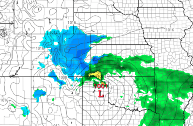
Models are in rough agreement that this system will produce around a 0.25″ of liquid in the Metro area, a little lower north and east and a little higher south.
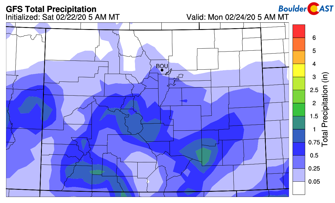
GFS total accumulated precipitation through Sunday
Considering the track and speed of the storm, in addition to the warm temperatures and daytime occurrence of the snowfall, potential accumulation amounts are going to be minor. Look for most of snow to accumulate on grassy and elevated surfaces. We expect this to be a coating-2″ snow event for most of the area, with perhaps not much sticking at all further north and east and possibly 2-5″ across far south Denver and the Jefferson County Foothills. Our snowfall forecast map for the event is shown below. This covers all snowfall through Sunday evening.

While it doesn’t look like this storm will offer quite enough punch to rocket Boulder into triple-digit snow for the season this weekend, there will be plenty of chances in the coming week. Check back for this and more in our weekly outlook on Monday. Enjoy the rest of this beautiful Saturday; Sunday sure will be different!
Help support our team of Front Range forecasters by joining BoulderCAST Premium. We talk Boulder and Denver weather every single day. Sign up now to get access to our daily forecast discussions each morning, complete six-day skiing and hiking forecasts powered by machine learning, first-class access to all our Colorado-centric high-resolution weather graphics, bonus storm updates and much more! Or not, we just appreciate your readership!

Subscribe to receive email notifications for BoulderCAST updates:
We respect your privacy. You can unsubscribe at any time.
.
Spread the word, share the BoulderCAST snow forecast!


You must be logged in to post a comment.