
May 2017 has already cracked the top 10 for wettest Mays on record in Boulder. Unfortunately, this trend looks to continue right until the end of the month. Read on for the soggy details as we provide our complete forecast for Memorial Day weekend.
What drought?
With a handful of days to go, a sizable 5.81″ of precipitation has been recorded in Boulder during the month of May. The map below shows the Front Range area as a whole has seen 1.5 to 3.5″ more than normal for the month…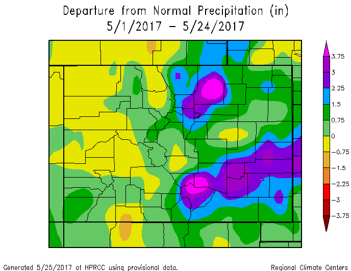
The drought that we rung in the New Year with has been all but eradicated, which is GREAT news! The Plains and Foothills are about as green as one can hope for this time of year.
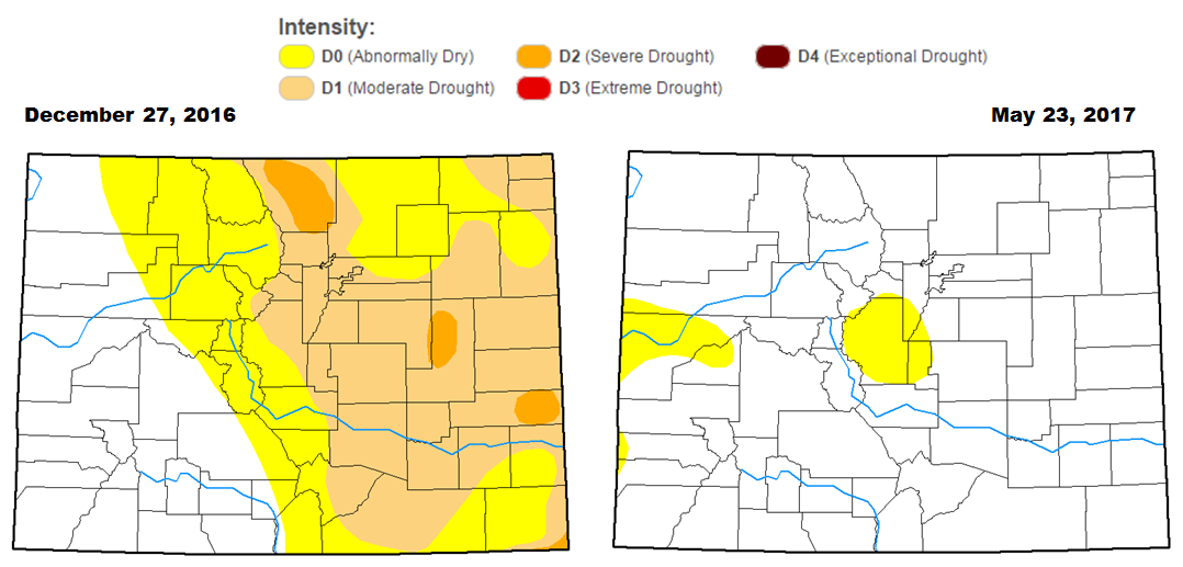
With last week’s round of rain and snow, drought has been wiped from the state of Colorado!
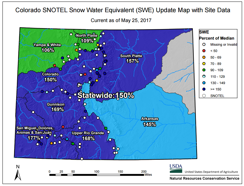
Our mountain snowpack statewide is healthy, too! So much so that you may have to wait a few extra weeks to reach your favorite locales in the High Country this year….
Plentiful precipitation and snowpack should keep the drought, wildfires, and fire bans away for the time being. Especially considering the upcoming forecast…
Stormy holiday ahead…
Will you be taking your first camping trip of the year this weekend? Parading to one of the numerous community pools that will be opening? Or maybe even participating in the BolderBoulder 10K Race? Memorial Day weekend marks the unofficial beginning of summer, one which this year will be plagued by the threat of storms each and every day.
Unsettled weather has already made its presence known this Thursday afternoon, with showers and storms filling the skies. The culprit of this activity is a broad trough of low pressure spinning to our north and west. Around the base of this trough, various pieces of atmospheric energy will make the traverse across Colorado from west to east today, tomorrow, and during the Saturday. While no one particular day looks to be totally rained-out over the weekend, the afternoon showers and storms will make “weather” more than just small-talk at your weekend BBQ.
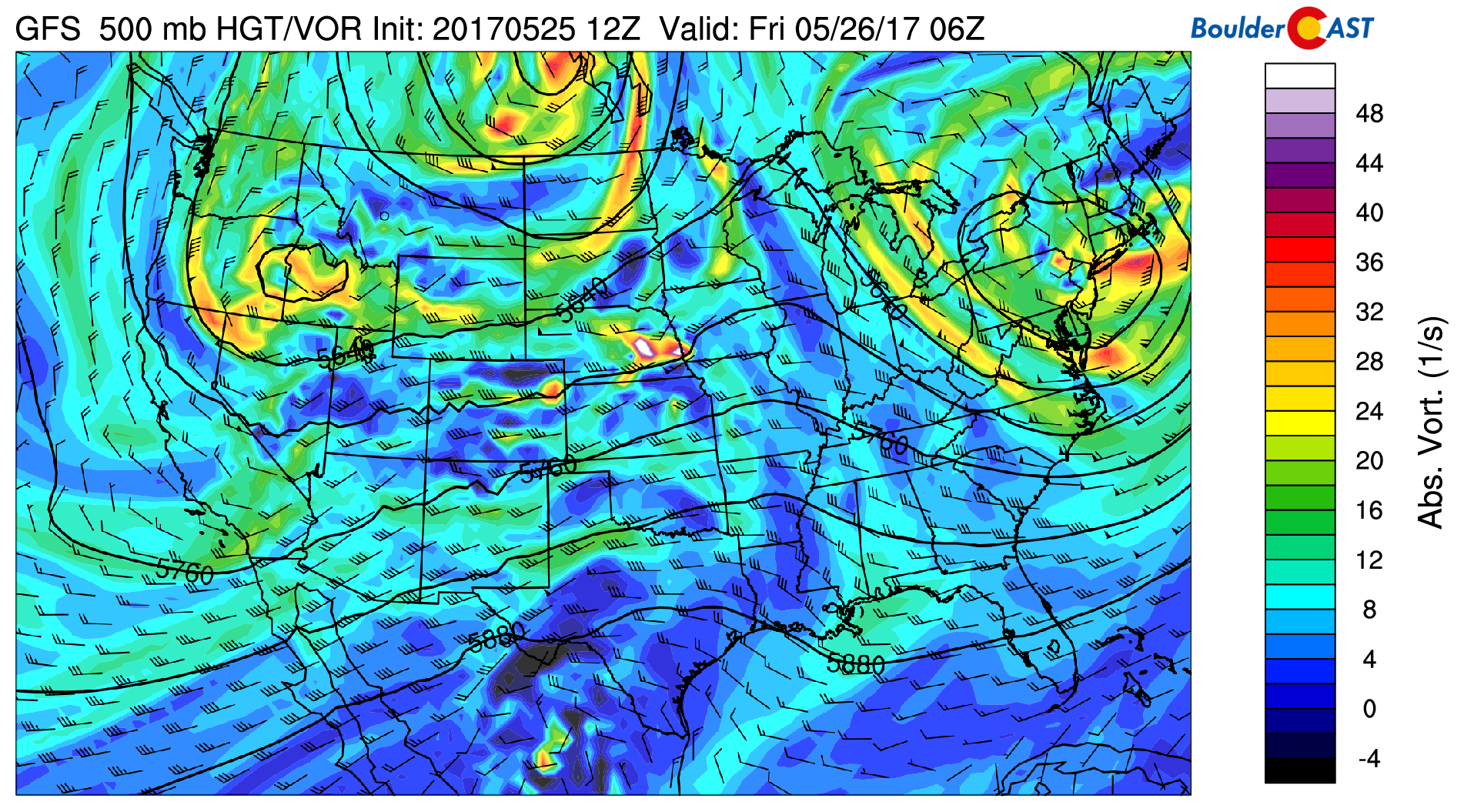
GFS 500 mb vorticity map for Thursday night. Troughy weather prevails across the West.
After storms die down overnight tonight, they will fire-up again across the Denver Metro area Friday afternoon. Late-May is prime severe weather season in northeast Colorado, and we’ll be watching the skies for a few severe storms Friday late afternoon and evening. The main threat for our region will be large hail. The Storm Prediction Center (SPC) has Denver (but not Boulder) in the yellow “Slight” risk of severe storms tomorrow. Keep in mind the SPC underestimated the threat today. With a very similar pattern in place tomorrow, we caution that things could be worse than this map indicates right now.
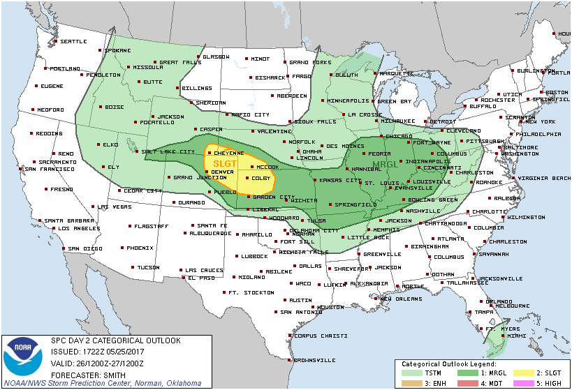
The SPC paints Denver at “slight” risk for severe storms Friday afternoon
The severe potential decreases Saturday, but instead there will be better forcing for precipitation as a trough and cold front combine to produce widespread showers and a few storms during the afternoon and evening. Models are in rough agreement that southeast Colorado will get hit harder than us, but still expect wet weather here as well. Saturday will be the ugliest day of the weekend, and the coldest with highs only near 60 degrees.
Snow levels Saturday will be around 9,500 feet. If you’re heading up one of the higher peaks Sunday morning, expect 1 to 3″ of fresh snow.
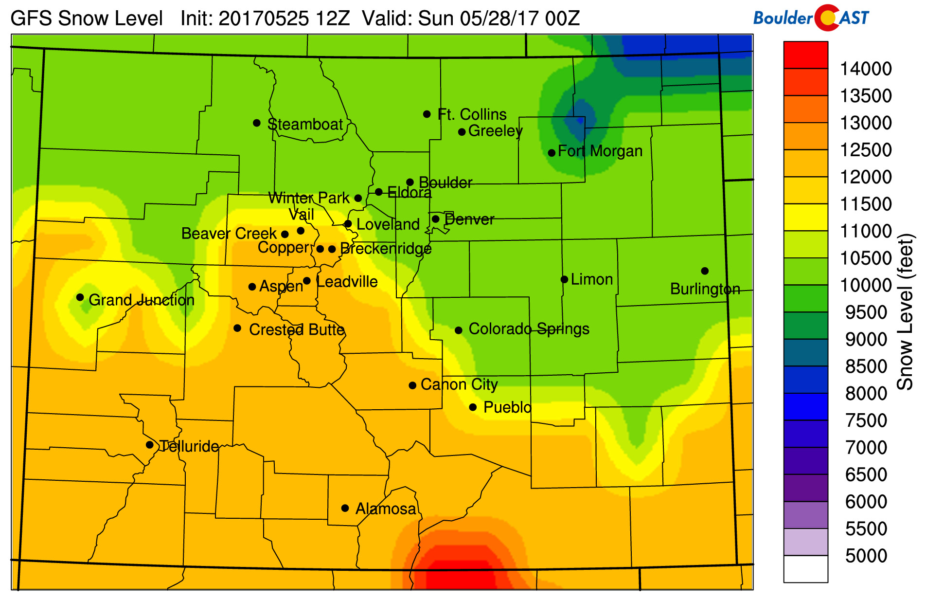
GFS model derived snow levels for Saturday evening.
Lingering moisture and instability will keep the chance of storms, albeit a smaller one, in the forecast both Sunday and Monday. Temperatures will warm back into the 70’s. Both days should be more hit-or-miss type of rain, with many areas remaining dry. The higher elevations will see better odds of storms, though.
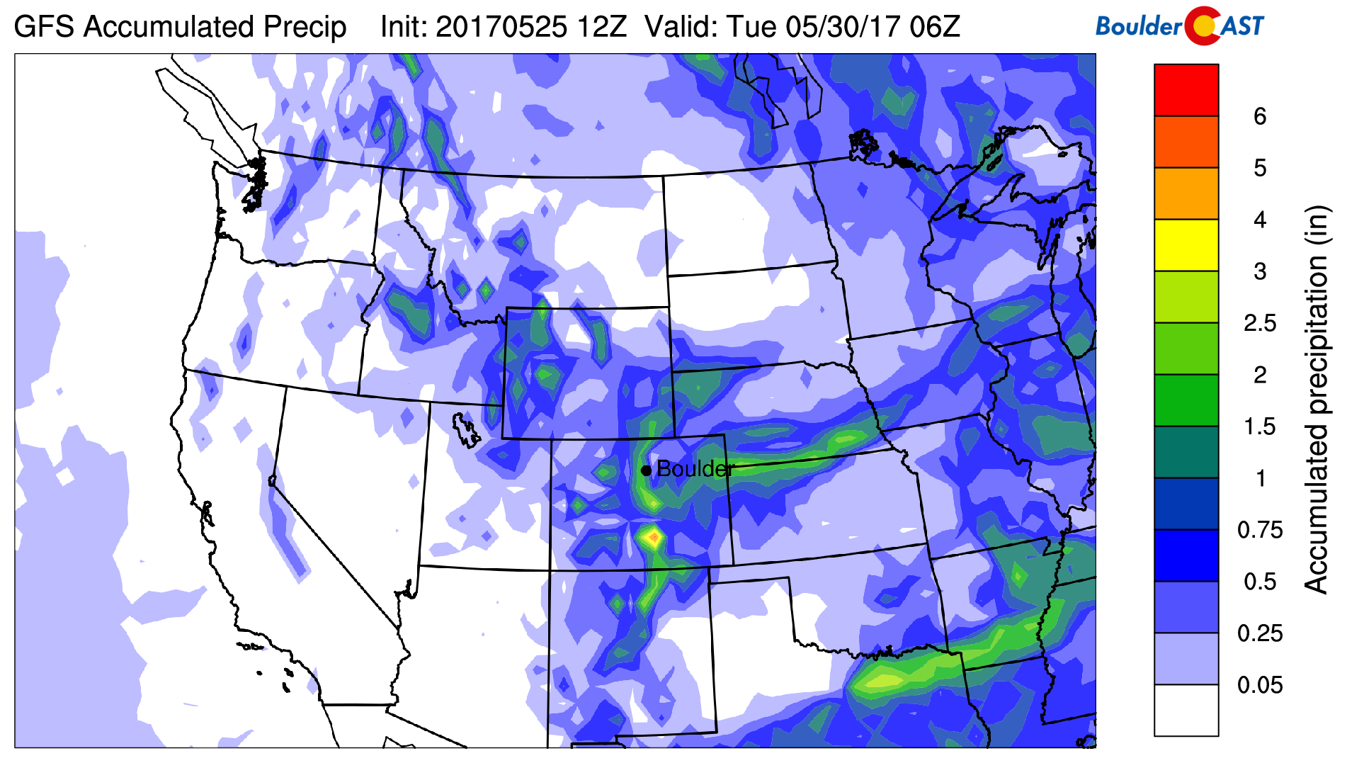
GFS total accumulated precipitation through Monday night. 0.75 to 1.5″ is indicated for our area, with more possible in the Foothills.
We wish you a safe and enjoyable holiday weekend! And don’t forget the reasons:
Forecast Specifics:
Friday: Sunny skies giving way increasing clouds. Spotty thunderstorms will developing in the afternoon and continue into evening. Storms could produce large hail across the Metro area, and maybe a few tornadoes east of Denver. Highs near 70 on the Plains and in the upper 50’s in the Foothills.
Saturday: The worst day of the holiday weekend. Expect some sunshine in the morning, with overcast skies and widespread rain showers developing through the day. Some thunder will be possible as well. Highs will only be near 60 degrees across the Plains, with upper 40’s in the Foothills.
Sunday: Partly sunny and seasonal with widely scattered afternoon showers and thunderstorms, especially across the higher terrain. Highs in the low 70’s for the Plains and low 60’s in the Foothills.
Monday: Sunny early with increasing clouds through the day. There will likely be isolated afternoon and evening thunderstorms across the Plains, with scattered storms in the Foothills. Highs will be even warmer in the mid 70’s for the Plains, and in the low to mid 60’s in the Foothills.
BolderBoulder: Monday morning looks like perfect weather for a race! The morning low should be somewhere between 45 to 50 degrees in Boulder with sunshine all around. Storms will be spotty and should hold off until the race is over anyways.
High Country: Showers and thunderstorms are in the forecast every day in the higher elevations. Snow levels will fall Saturday along the Divide, with 1-3″ of snow possible by Sunday morning above ~10,000 feet. Sunday and Monday will have lower chances of storms, but by no means will be ideal for outdoor activities.
Don’t be selfish…share our forecast with your friends!
Fri
Sat
Sun
Mon


Temperature
70
60
71
76


Precip Chc (Plains)
30%(pm)
70%
20%(pm)
20%(pm)


