A quick update on today’s weather as a cold front arrives later this morning bringing snow to the region. Model disagreements, even in this final hour, leave some uncertainty into how much snow may fall. Read on for all the details.
We mentioned in our outlook earlier this week that we were watching a cold front for Thursday which could bring a period of light snow to the region during the second half of the day. That forecast is still on track as a cold front is knocking on the door this morning. It actually briefly moved though yesterday afternoon, then retreated back northward. Very odd behavior, indeed.
Below is the temperature time series from yesterday in North Boulder. Temperatures were in the 50’s through mid-day. However, around 1:30 PM, the front arrived, dropping temperatures into the 20’s and even a light dusting of snow fell in areas near Boulder. As quickly as the front showed up, it exited around 7 PM with temperatures climbing back into the 40’s.
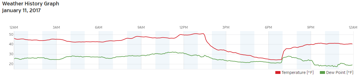
BoulderCAST time series of temperature (red) and dew point (green) for Wednesday.
After the front moves through again late this morning, light upslope will ensue and combine with weakly favorable upper-level dynamics to produce snow in and near the Foothills. The best time-frame for snow is from 1PM through MIDNIGHT. The model consensus is most of the snow will remain west of Interstate 25 where the upslope will be most influential. However, the HRRR high-resolution model is predicting a line of convergence right across Boulder/Denver this afternoon and evening. This convergence will provide extra lift to produce an extended period of more moderate snowfall as moist southeasterly flow overruns the cold front. The below simulated radar image from the HRRR is for the rush hour time-frame tonight…
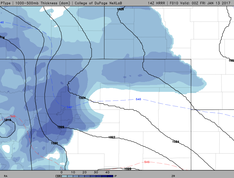
HRRR simulated reflectivity forecast for snow this evening. A heavier band is set up across northwest Denver and Boulder.
Consequentially of this heavier snow, the HRRR is producing sizable snow totals for the region, generally 1 to 3″, with some indication that isolated locations could approach 4 to 6″ if the more moderate snow remains overhead for a while.
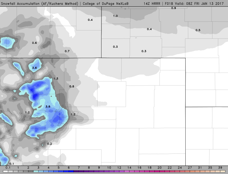
HRRR snowfall forecast through 1:00 AM tonight.
Temperatures will be in the 30’s this morning, falling into the 20’s this afternoon behind the front. Snow accumulation on the roads will initially be inhibited, but as the sun sets, roads may become slick. Rush hour will probably be fine, just take it slow.
Without the small scale physics incorporated into the HRRR, we wouldn’t have much ability to predict this afternoon’s snow. The GFS, NAM and European models are not of high enough resolution to be able to resolve that topographically-forced convergence line. As a result, they are predicting 1″ or less almost everywhere (and so were we until we saw the HRRR runs this morning). Just another forecasting complication introduced by the Mountains and Foothills surrounding Denver. This leaves us a little weary that the HRRR may be overdone, but we’ll roll with it for now. If it verifies, we may see Winter Weather Advisories posted later this afternoon.
Alas, it’s almost Friday. Enjoy the snow! There may be more on the way for Sunday, though we think that storm will mostly be for southern Colorado.


