After experiencing near-record snowfall last winter with a historically strong El Niño in place, the better part of the last year has seen below normal precipitation across most of eastern Colorado. Drought has continued to expand and intensify through the winter season. However, a fruitful pattern shift is ahead, beginning with our first spring storm of the year! Continue reading as as we provide an update on the drought and our thoughts on the upcoming storm.
Current drought has been a full year in the making
Last winter’s record-breaking El Niño produced big snow totals across the Front Range, and as a result, we had a nearly non-existent wildfire season last summer. However, things have changed since then. Big time. Over the last year, the Front Range has been one of the driest places in the western United States in terms of percent of normal precipitation. This is something we predicted time and time again.
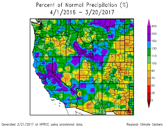
Percent of normal precipitation observed over the last year. Colorado and Denver have been very dry.
Since April 1, 2016, Boulder has recorded only 10.4″ of precipitation, just 62% of the normal 16.7″. Denver had even less, just 7.9″ (which is 65% of their normal 12.2″). 9 of the last 11 months concluded with below normal precipitation in Boulder, and we’re yet to see any measurable precipitation in March (though this will change Thursday evening…more on this later). With this, vegetative conditions are now primed for a dicey wildfire situation east of the Continental Divide as we head into the spring months.
The maps below show the change in areal drought coverage across the state of Colorado during the last twelve months. Clearly eastern Colorado has gotten the short end of the precipitation stick. The entire Denver Metro area is now experiencing Moderate Drought. The city of Denver, Broomfield, and Fort Collins are within the Severe Drought denotation.
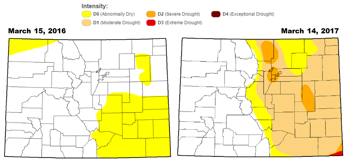
Colorado change in areal drought coverage over the last year.
Despite the dry weather east of the Continental Divide, the Mountains are doing fine with above normal snowpack across the board so far this winter.
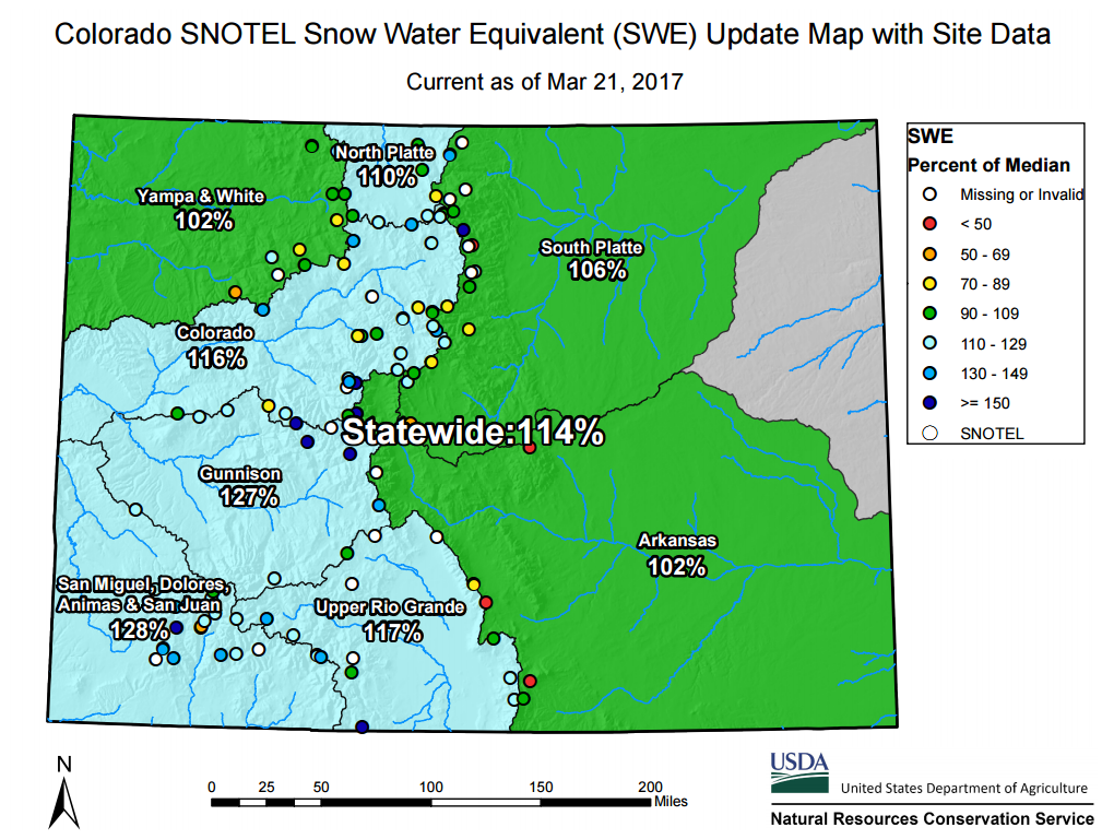
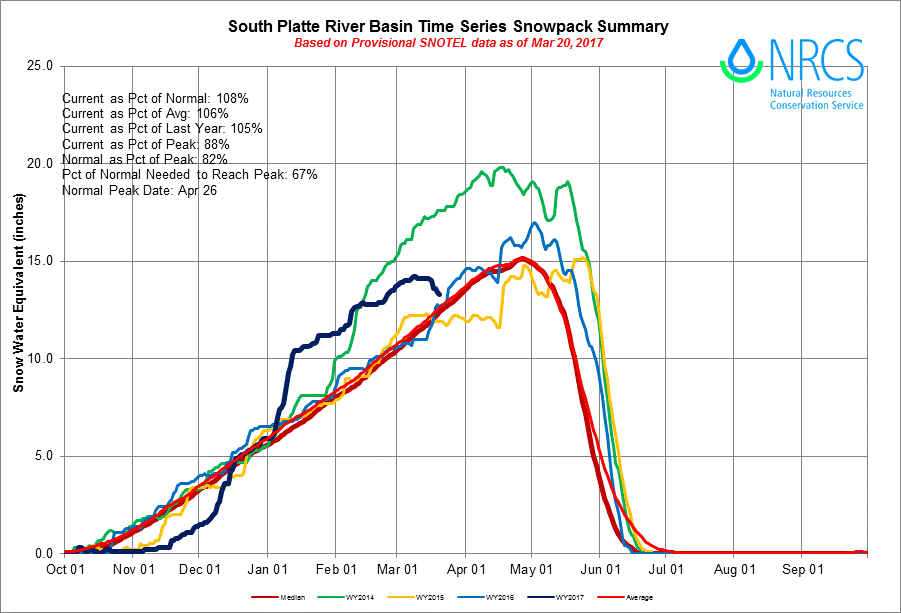
This surplus of snow is mostly thanks to numerous big dumpings way back in December and January. The time series of snowpack for the South Platte River Basin (the one including the Front Range) shows the stagnation in snowpack since mid-January (graph below). Last week’s record warmth has also affected Colorado’s High Country. The “heat wave” spurred-on a rapid decline in snowpack, AKA melting (see the navy blue line below). Seriously, temperatures soared into the 40’s and 50’s for all the major ski resorts. That shouldn’t happen at 11,000 feet in March! After a promising early powder season through January, some skiers are likely finding it hard to use up their remaining lift tickets. Unless of course tearing it up on a mix of slush and ice is desirable (possibly to increase the pain or difficulty factor?).
Spring precip is right around the corner!
In our weekly outlook discussion on Monday, we unleashed our excitement for a late-week spring storm that was eyeing the Front Range. The set-up is a classic upslope event for the region, with a upper-low moving across the Four Corners region Thursday night…
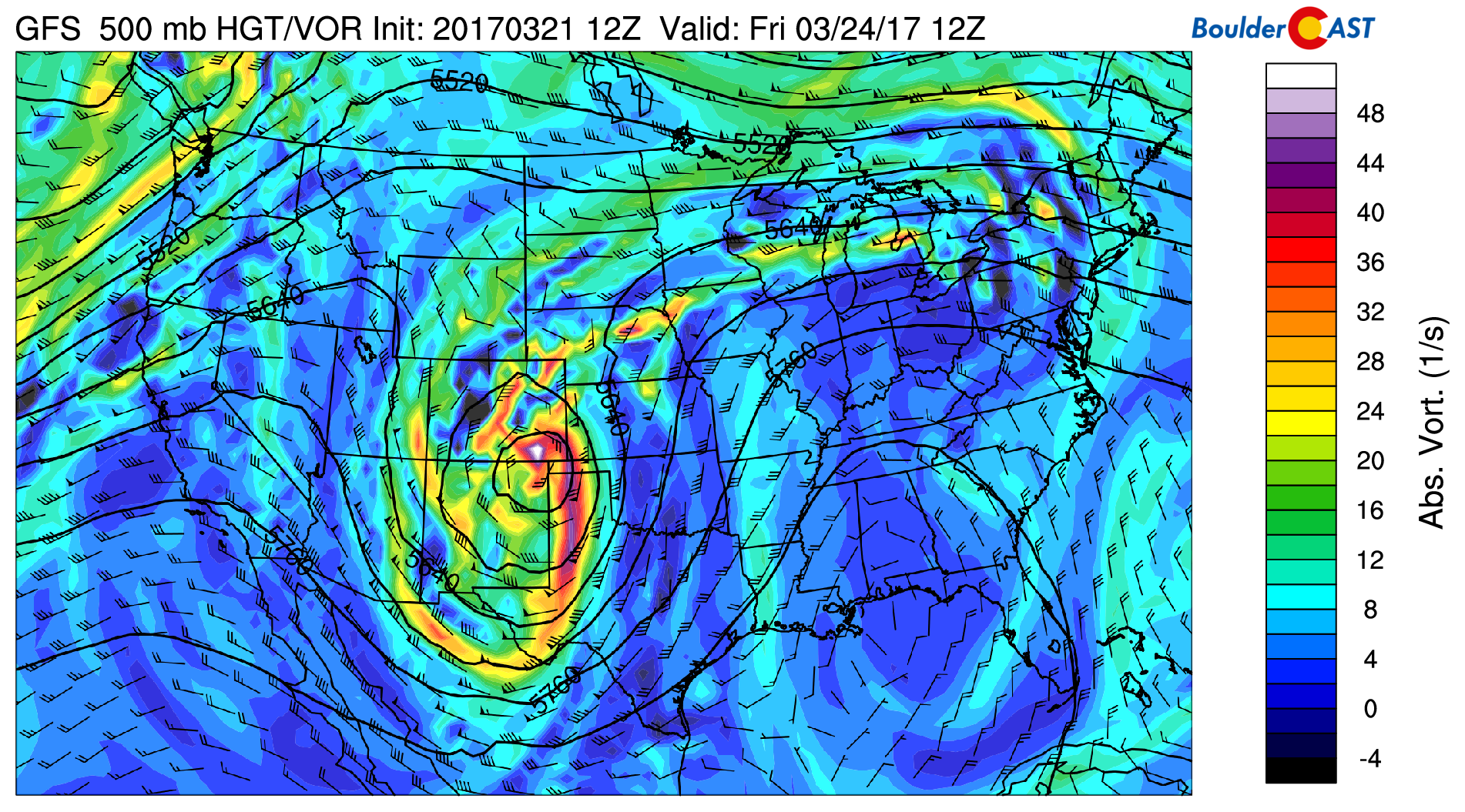
GFS 500 mb vorticity map for Friday morning showing the location of upper-low along the Colorado / New Mexico border
and a surface low rapidly intensifying in eastern Colorado Friday.
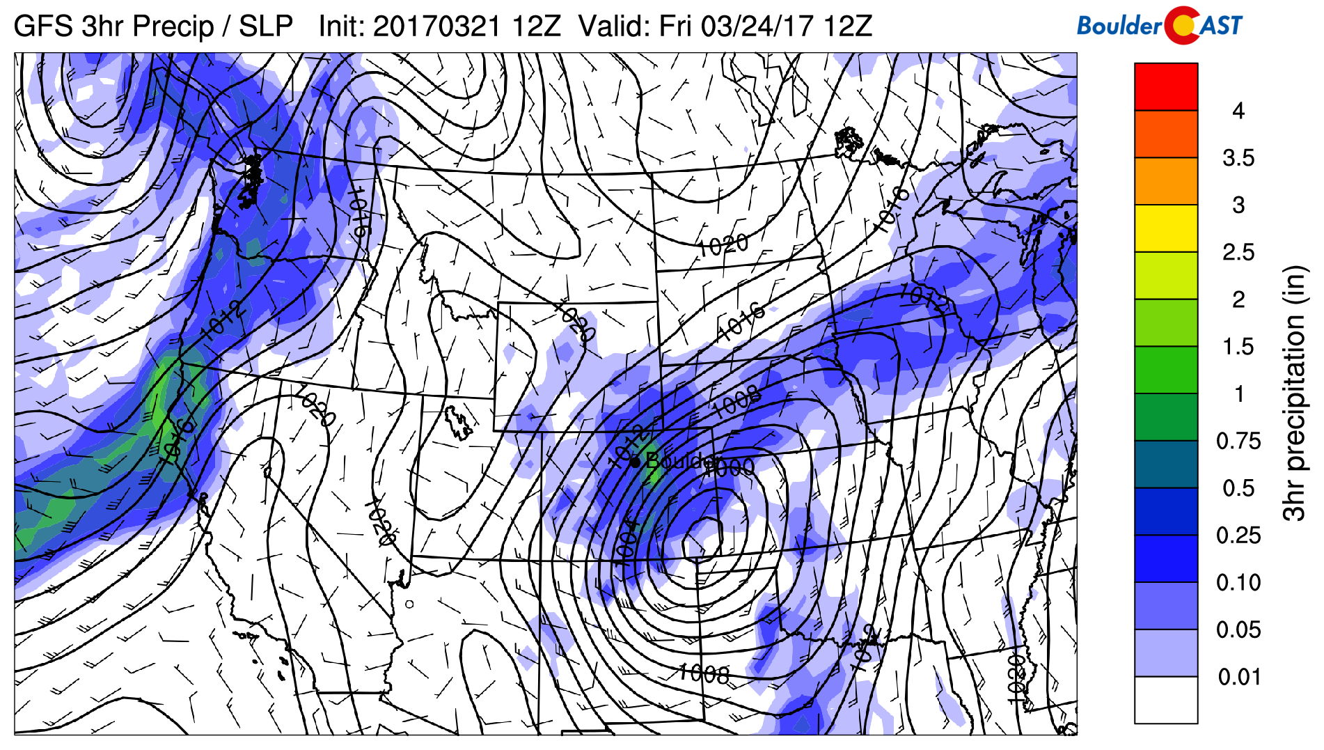
GFS sea-level pressure and precipitation map for Friday morning showing a powerful surface low forming in southeast Colorado.
This is shaping up to be a significant storm for the region. We’ll get many hours of ideal conditions to squeeze the moisture out of the atmosphere across the Metro Area. Both the NAM and GFS models have consistently been dropping more than 0.5″ of liquid in Boulder and Denver for this storm. Some of the more bullish runs exceed one inch. Though, an observable trend over time has been the migration of the heaviest band of precipitation south and east of the Denver Metro towards the core of the surface low (see below). This trend will need to be monitored as Boulder is already on the northwest fringe of the precipitation shield. Any further shift and we’ll see precipitation totals drop off significantly.
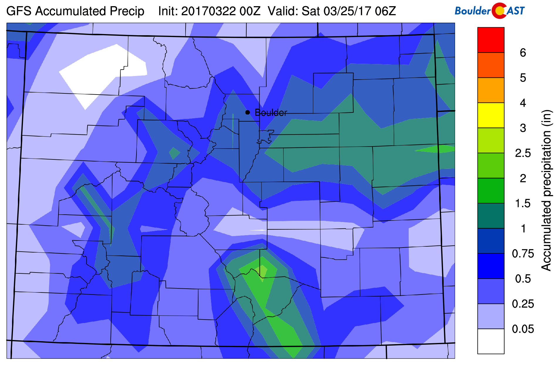
GFS total accumulated precipitation forecast through Friday night. 0.5 to 1.0″ is indicated for the region.
Unfortunately, it looks like there isn’t enough cold air with this system to make the transition to snow for the lower elevations. It’s going to be a rain event for the most part, with a chance for a brief mix over to snow Friday morning. Little to no accumulation is expected below 6,000 feet. However, in the Foothills above ~8,000 feet, hefty snow totals will be possible. Somewhere on the order of 5-12″ we think at this point. The lower Foothills could pick up a few slushy inches as well. The big winner for snow could very well be the Palmer Divide south of Denver.
The storm will rapidly strengthen in eastern Colorado before moving east into Kansas Friday evening. The pressure gradient will be tight, so in addition to the rain, wind will also be a factor. Gusts Thursday night and Friday could exceed 40 mph. Friday should be a total wash-out with highs remaining in the 40’s across Boulder and Denver.
One storm alone isn’t enough to make much of a dent in the drought. However, after a dry day Saturday, precipitation returns for Sunday and likely several days next week! The pattern shift we have been discussing for several weeks has finally arrived!
Check back for our final storm forecast and snowfall map sometime tomorrow (Thursday).
.


You must be logged in to post a comment.