Beginning last Friday, snowfall has been falling intermittently across the Mountains of Colorado resulting from several shortwaves and pockets of moisture hanging out in the northwest flow. The most recent pulse which occurred from Monday morning into Tuesday afternoon generated snow totals of 7 to 15″ across much of the High Country. For the first time this winter, skiing was actually decent on Tuesday! Despite this, snowpack remains disconcertingly low statewide. We check-in on the status of our snowpack and provide our thoughts on another system eyeing the Front Range this weekend.
We were also closely tracking Monday night’s system for the potential to produce isolated jet-forced snow bands across the Metro area. The 250 mb wind forecast graphic below shows the jet streak that developed across Kansas Monday evening. The left entrance region of the jet streak is boxed in purple. This is the general area we would expect to see the snow bands form. Notice that the Denver Metro area was just on the edge of this region.
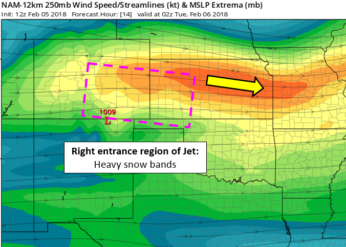
There were indeed a few impressive bands that did form Monday night and early Tuesday, but they largely stayed south and east of DIA. While the upper-levels were slightly favorable across the Metro area, the lower levels were drier and the upslope weak. Snow bands coming off the higher elevations tended to fall apart, only bringing a few flurries to the Plains with a thin dusting of snow reported in spotty locations. The map below shows snowfall totals from the event.
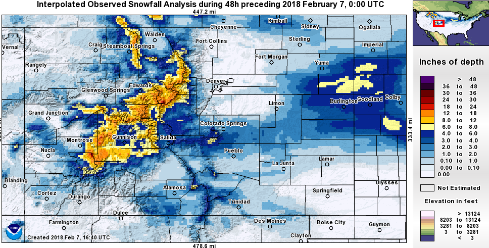
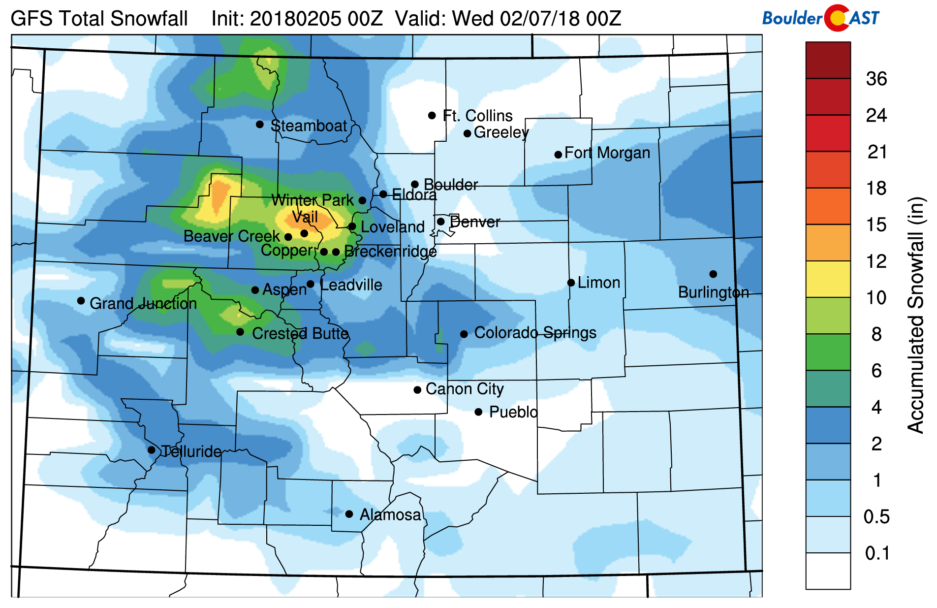
The observed snowfall totals (above) matched up very nicely with our GFS model-derived snowfall map (below). This is often not the case. We’ll consider this a win for the American GFS model!
Shown below is our original forecast map created Monday morning for the northern Metro area. The observed storm totals per location are contained in boxes. Green ones indicate that the observed snowfall was within one inch of the given forecast range, while red was outside the scope of our forecast (there is no red).
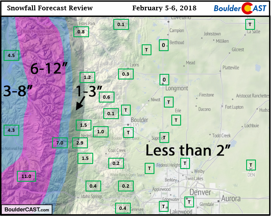
Overall, it was not a difficult snow forecast. We expected most areas below 8,000 feet to see little if any snow. The isolated bands were however ever more isolated than forecast (essentially non-existent). Boulder and Denver both reported just a trace, with 1-3″ near Nederland and 7.0″ at Eldora. The highest totals were near the Continental Divide (11.0″ at the top of Berthoud Pass).
Seasonal Snow Totals (Updated Feb 6 2018)
| Boulder | Denver |
|---|---|
| 31.9" | 13.2" |
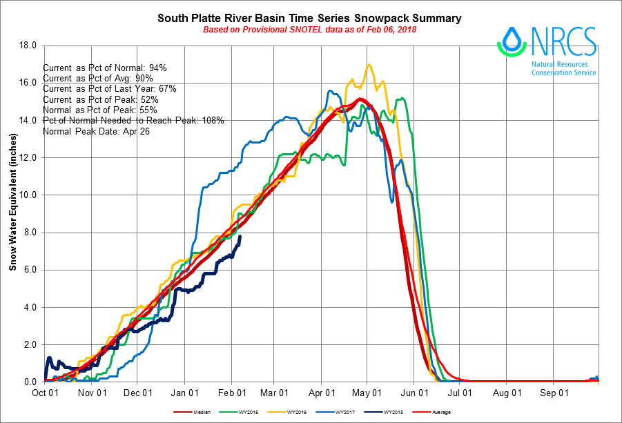
The South Platte River Basin time series of snowpack below shows we are at 94% of normal, including the recent snows. The dark blue line is this year, while maroon is the median (normal) snowpack.
Statewide, snowpack is much more concerning, especially in southern Colorado…
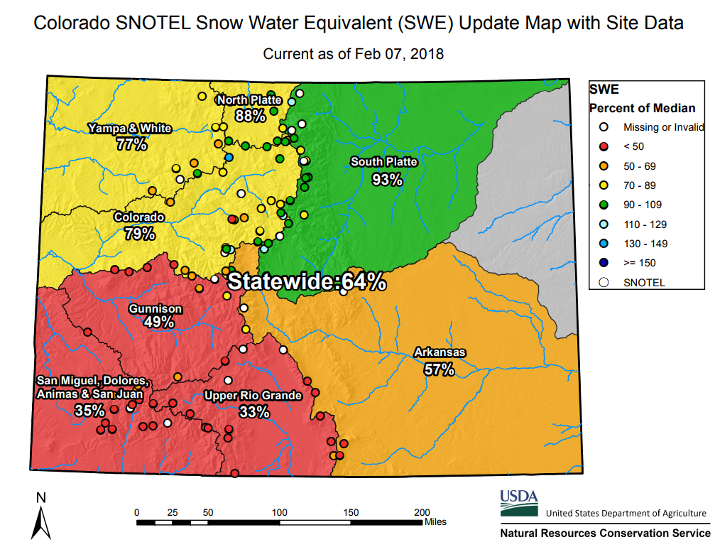
Surprisingly, this is an improvement compared to where it was one month ago, but we’re definitely not at all in good shape right now. There’s still time to recover; massive spring snowstorms have saved us before…most recently in 2013 and 2015. It’s not impossible, but given our “warm and dry” outlook for the next three months, we wouldn’t be placing any bets. Things are NOT likely to improve. We look for an active fire season and intensifying drought for Colorado as we head through the spring season.
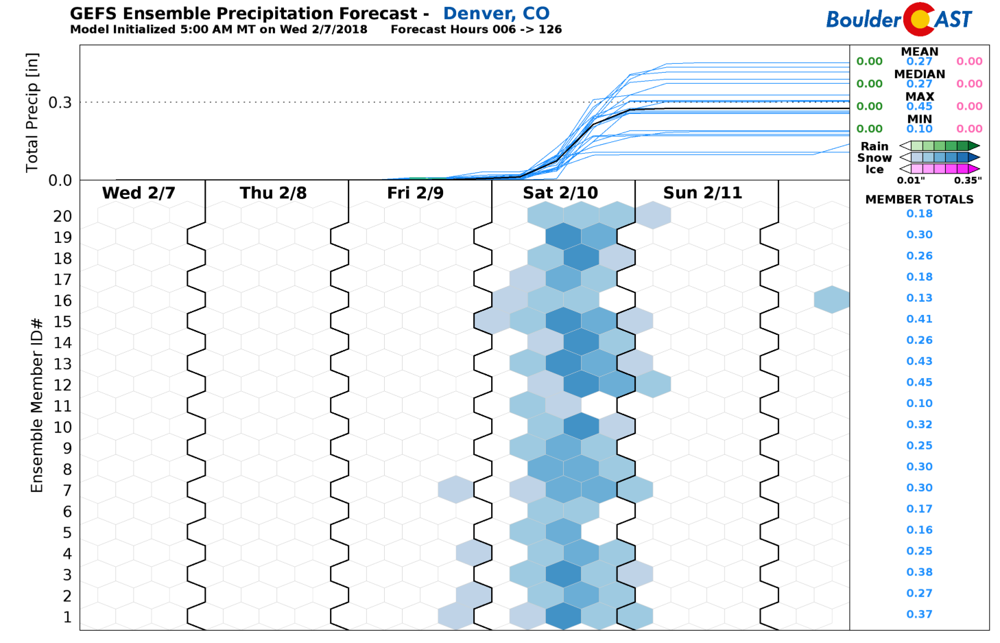
If you have been following along with us this week, or if you’re a Premium subscriber, you’ll know we are tracking more snow for Saturday with the arrival of another cold front. Our thoughts now are that the coldest air and snow will move in Saturday morning with several inches of accumulation possible through the daylight hours. The GFS ensembles have been consistently indicating a 2-5″ event (see below), however this is the snowiest model right now. Temperatures Saturday will only be in the 20’s and teens. Brrrrrr!
That’s all for now. We’ll likely have another forecast out Friday for the weekend’s snow. Stay tuned….
Subscribe to receive email notifications for BoulderCAST updates:
We respect your privacy. You can unsubscribe at any time.


