We’re comfortably in the 70’s now, but rain and snow are looming. A few model shifts over the last twenty four hours have altered a few aspects of the forecast for the spring storm set to arrive this evening. Read on for all the details!
SET-UP:
A strong upper-low will move into the region this evening. It will deepen and cut-off as it traverses across southern Colorado on Friday. This timing and track of the system have been well-represented by the models since Monday. There are excellent dynamics and moisture alongside this storm, by far the best we’ve seen in many months.
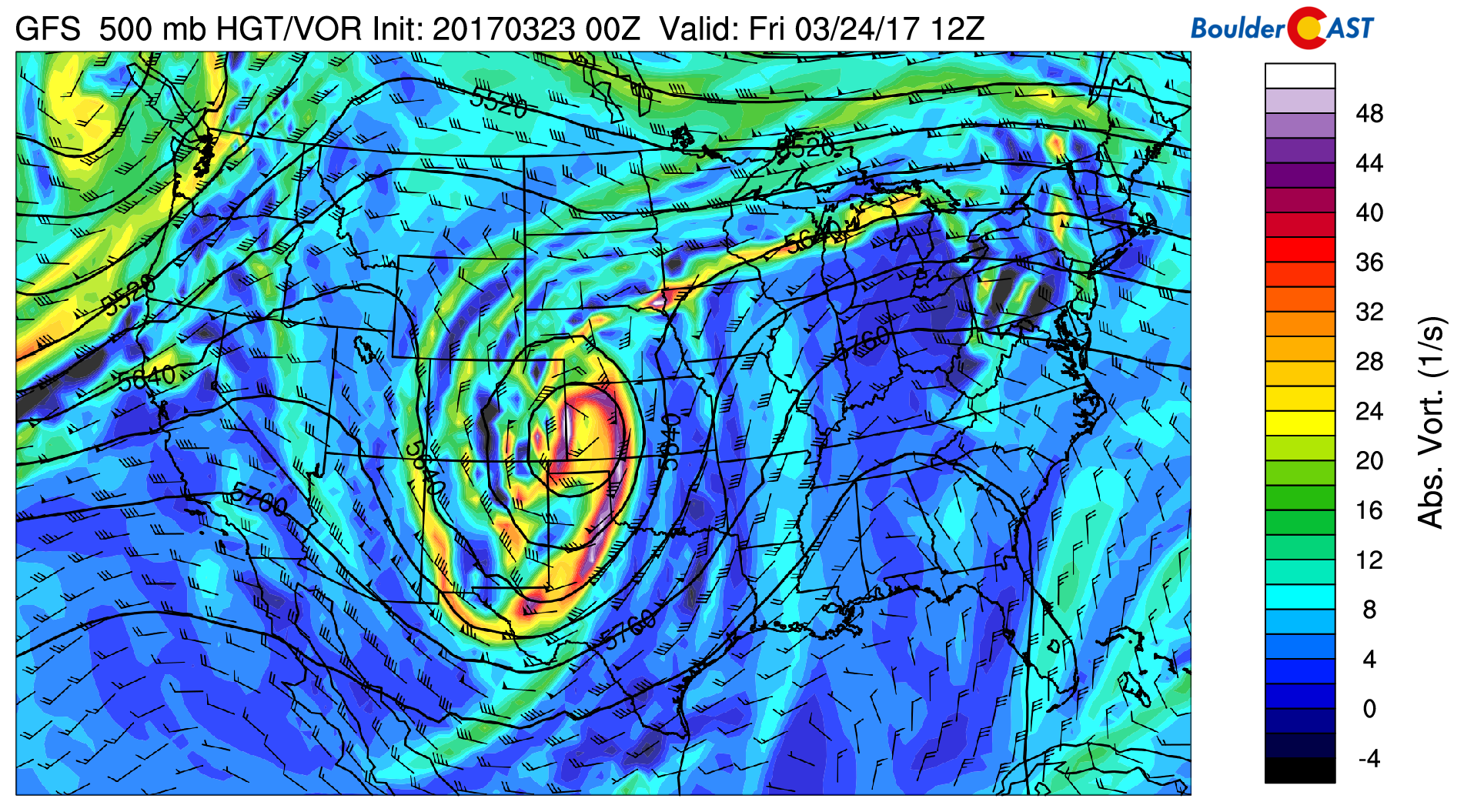
GFS 500 mb vorticity map for Friday at 6AM showing the position of the upper-low in southeast Colorado
Low-level pressure gradients are very tight (thanks to rapid cyclogenesis near the forming low), so winds will also be whipping as the surface low develops in southeast Colorado (see below). The 800 mb wind map below shows north-northeasterly winds sustained at 45 mph over Denver and Boulder (this level is just above ground-level).
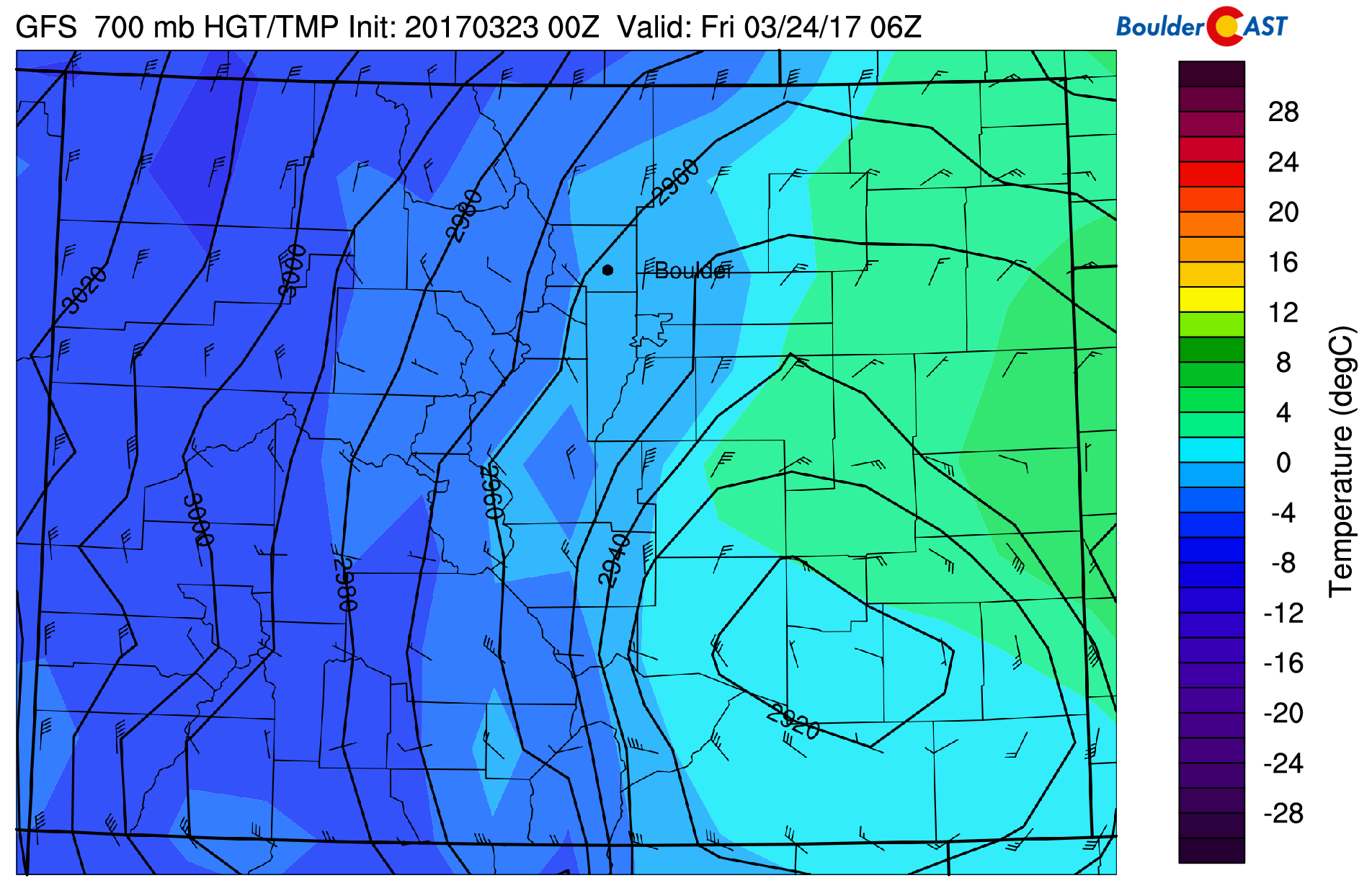
GFS 800 mb temperature and wind map for 12AM Friday showing the developing surface low and strong pressure gradient.
This combination of favorable dynamics, moisture, and upslope (in spots) will lead to a decent spring storm for the region. It will provide much needed precipitation to locations that haven’t seen any in almost a month..the same regions that are currently experiencing a moderate to severe drought.
MODEL CHANGES:
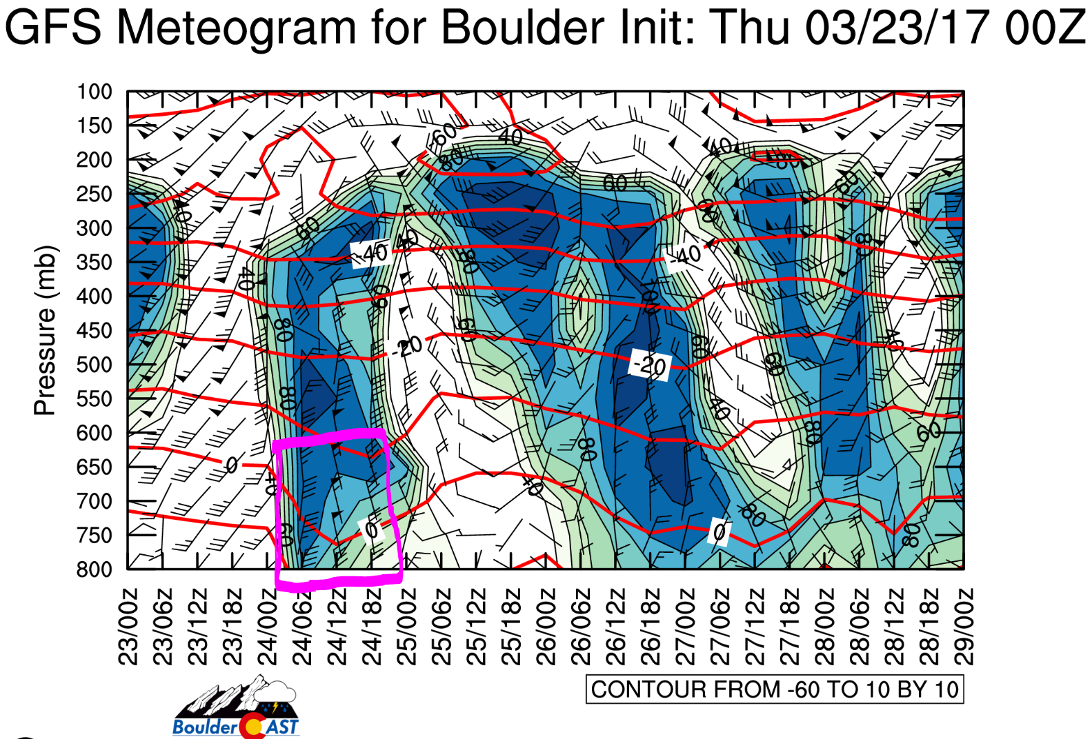
The first model change was somewhat expected. Despite a fairly consistent track of the upper-low in most model runs, the location where the surface low forms has shifted slightly further southeast than we were seeing a few days ago. We did mention this was a possibly in our last forecast update. The meteogram below shows what this change has done to Boulder’s wind-field. The duration of the storm is highlighted in pink. Notice a distinct lack of upslope below the 600 mb level. In fact, strong NNW winds set up as early as 6AM Friday. For this reason, we think precipitation totals will be lower than originally expected in Boulder and the northern Denver Metro area in general.
This next change is somewhat related to that southeastward shift. We’re now expecting slightly colder temperatures to make their way southward into the Denver Metro area. Thursday afternoon will be very warm and springlike with temperatures in the 70’s. As you can imagine, snow levels will be VERY high initially, 11,000+ feet high! However, once the cold front moves in after sunset, snow levels will be tumbling, down to around 7,500 feet by midnight, and 6,000 feet by 6AM. Temperatures will bottom out early Friday morning in the 33 to 39-degree range across the Plains (depending on elevation and intensity of precipitation). We’re even seeing some indication that the snow level could briefly come down to Plains-level around sunrise Friday. For this reason, we’re not ruling out accumulating snow in the Denver Metro area…in fact, we’re actually expecting it!
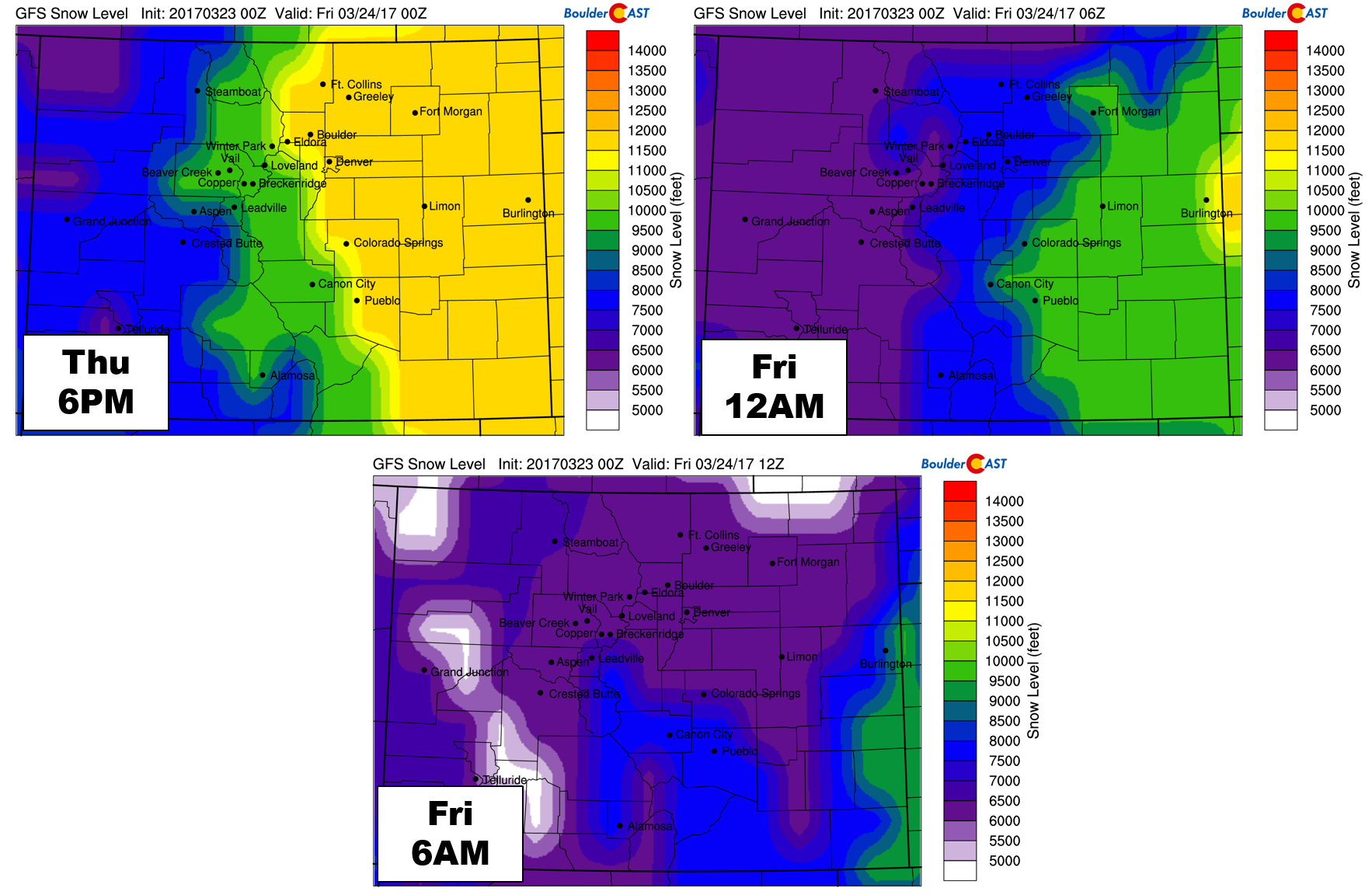
GFS-derived snow level maps for three times showing the drop in level through the course of the storm.
The strong northerly flow coming into Boulder County will actually be downslope from the Cheyenne Ridge north of Fort Collins. As we have seen many times before, this added downslope can boost temperatures a few degrees. Snow potential is already marginal for the region, so this added warming that is likely to occur northeast of Boulder could severely limit any potential for snow there. You will see this reflected in our snow map below.
TIMING:
The cold front arrives around sunset or slightly after this evening. Precipitation will commence shortly thereafter, beginning as rain for everyone, even the Foothills. Snow levels will be falling through the night as colder air filters in and precipitation expands and intensifies. The best chance of heavier precipitation will be from midnight to 6AM. The best odds of snow in and around Denver will be from 3AM to 9AM, so there could be some overlap the heavier precipitation and an atmosphere that may support snow.
RAIN/SNOW AMOUNTS:
We’re less optimistic for precipitation from this event now than we were in prior days, at least in Boulder County. The wind field is impressive, but unfortunately not favorable for upslope at all near Boulder. However, northerly winds are upslope for the Palmer Divide and the southern Denver suburbs, so consequentially, that is where we believe the heaviest snow totals will be. If anyone can exceed 12″ of snow from this event and truly call this one a blizzard, it will be there!
Models continue to represent a sharp gradient in precipitation right across the Denver Metro Area, less northwest and more southeast (see below). With this, the forecast becomes very tricky, particularly if snow becomes a little bit more widespread. The GFS model continues to indicate about 0.3 to 0.7″ of precipitation for Boulder County, scaling upwards towards 0.5 to 1.0″ in Denver, with 0.8 – 1.2″+ southeast of Denver. The NAM model has the drop off even closer to Denver, resulting in lower amounts everywhere. The HRRR looks to be aligning somewhere in between the two.
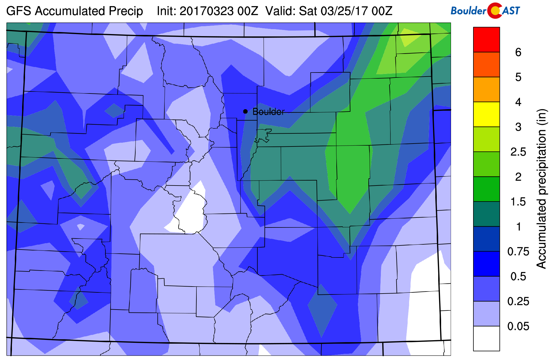
GFS total accumulated (liquid) precipitation forecast through Friday evening. Notice the sharp precipitation gradient across the Denver Metro area.
Here are some of the many factors we are considering in our snowfall forecast map:
- Very warm ground temperatures resulting from 70+ degrees Thursday. Snow will have a tough time sticking anywhere but grassy and elevated surfaces.
- Potential for downslope warming from the Cheyenne Ridge resulting from 40 mph northerly winds. This would likely keep things mostly rain northeast of Boulder into Longmont and Loveland.
- Unfavorable upslope flow overall, except south of Denver. With so much moisture hanging around, this may not even matter.
- Areas that do see the change over to snow will see signifcant snowfall rates of 2″ per hour.
- Limited window for snow to occur before we begin re-warming Friday morning when the sun comes up
- Position of the surface low well southeast of Denver. Will it be too far from Boulder?
- Sharp gradient in forecast precipitation amounts lies right across the Metro Area. Some areas will do great, others not so much.
The forecast has quite a high bust potential in our opinion, particularly resulting from the last bullet above. We’re especially concerned about the potential for areas near Denver and south pushing past our snowfall forecast. There are A LOT of factors at play, which don’t always need to be considered in late March. Last year we got lucky to have plenty of cold air, even into late April to “easily” be able to forecast snow. This storm does not provide us this benefit!
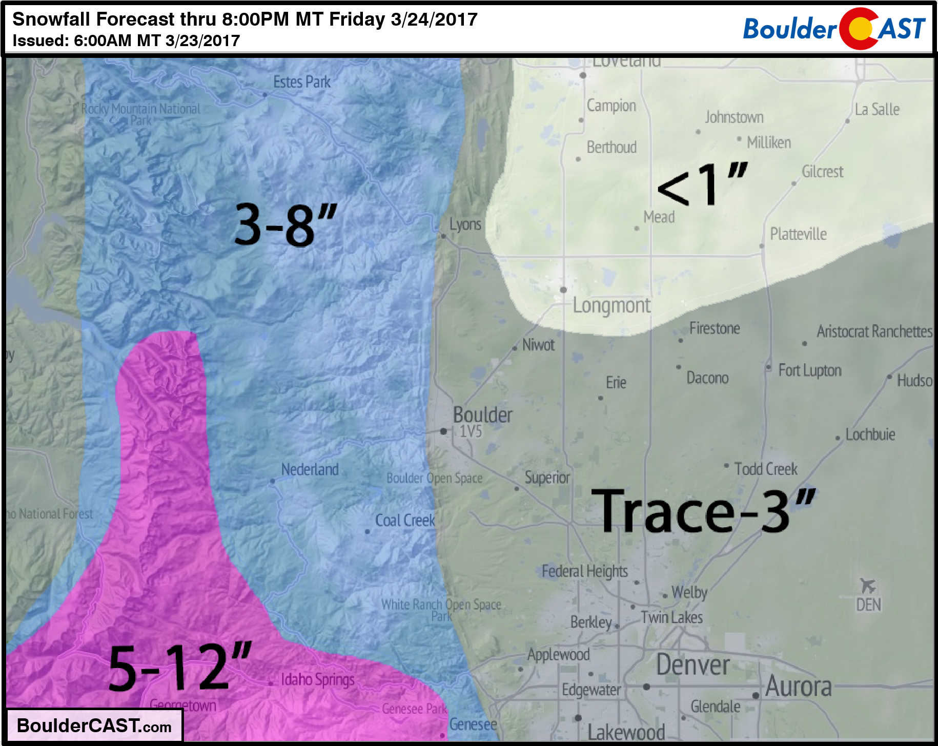
We believe the highest bust potential for MORE snow than our forecast is in areas like Aurora, Commerce City, and DIA. The National Weather Service has issued a Winter Weather Advisory calling for 3-6″ on the Plains. This includes the entire Denver Metro. While possible, we believe most areas will fall short from this forecast.
Temperatures will warm back into the 40’s Friday morning, so any snow will change back to rain as snow levels increase back towards 7,000 feet during the day. Precipitation should wind-down late morning or early afternoon. Highs will remain in the 40’s on the Plains and in the 30’s in the Foothills.
Enjoy the first of many spring upslope storms! Tonight is just a taste of what’s to come. The pipeline looks quite active for them to continue every 3 days or so heading forward.


