
Spring is in the air! An interesting weather setup is taking shape to change rain over to snow across the Boulder-Denver area late in the day Sunday into Sunday night. In general, snow amounts will be just a few inches, but we are concerned that springtime convection and cold temperatures may combine Sunday evening to produce embedded pockets of very heavy snow, possibly accompanied by thunder. Read on for our complete forecast and our thoughts on where thundersnow is most likely Sunday evening.
N
ot unlike what transpired just one week ago, rain and snow will overtake the Front Range again this evening as an elongated trough pinches off into a cut-off low pressure system across California. The large-scale atmospheric set-up is shown below.
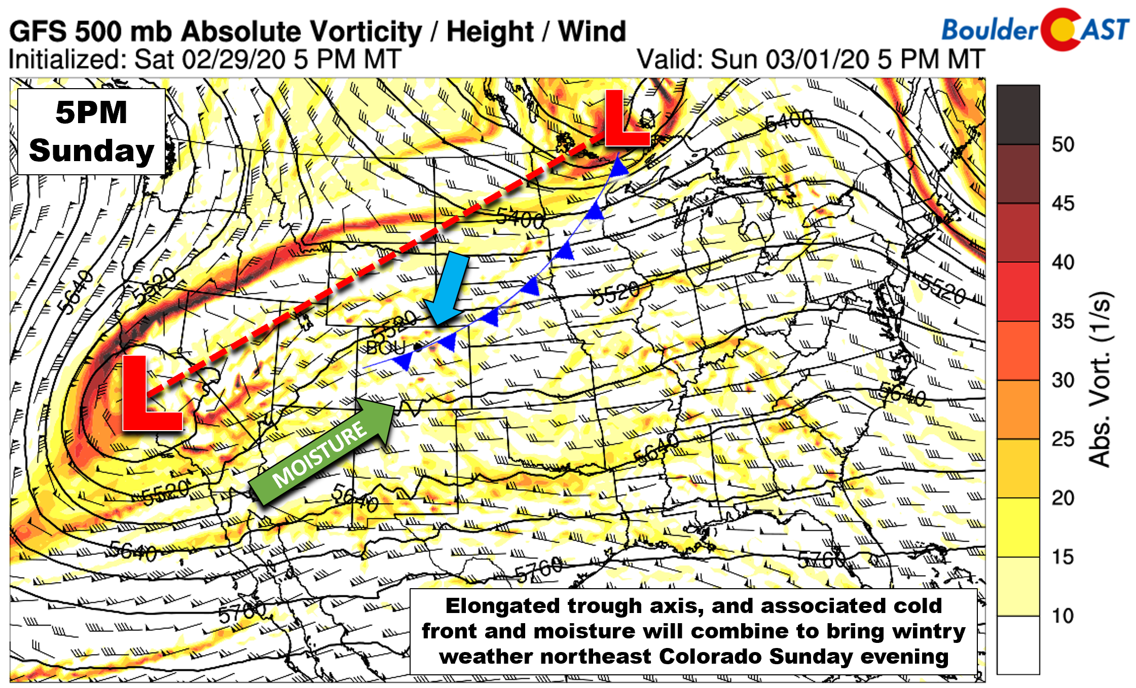
GFS 500mb vorticity forecast for Sunday evening showing the large-scale setup across the country
The GOES-East water vapor satellite animation below shows the main players involved: 1) the cut-off low developing near San Francisco, 2) a strong mid-latitude low pressure progressing along the North Dakota-Canada border, and 3) the moist subtropical jet stream zooming into Arizona and New Mexico.

GOES-East water vapor animation from Sunday morning
While the developing low is indeed rather far away from us in California, weak energy will push in from the southwest across Colorado Sunday evening along with plenty of subtropical moisture from the Pacific. This off-shoot of energy from the main low is something we have been watching for the last several days. We had hoped that is would come in a little stronger when it materialized, but that’s not how things have played out. There will also be weak diffluence aloft, though this is mainly across Wyoming. Both of these factors will aid in a period of widespread but weak large-scale lift across the Front Range Sunday evening.
On their own, the trough and diffluence wouldn’t be much of a bother for us. However, as is usually the case, at the same time a potent surface cold front will be dipping southward across the Denver Metro area. A weaker front has already pushed through as of Sunday morning, which is why we’ll be stuck in the 30’s today (compared to near 60 degrees the last two days), but the main frontal boundary won’t blow through until early evening. This front will throw additional lift, low-level moisture, and upslope into mix to initiate precipitation across the Front Range by early evening.
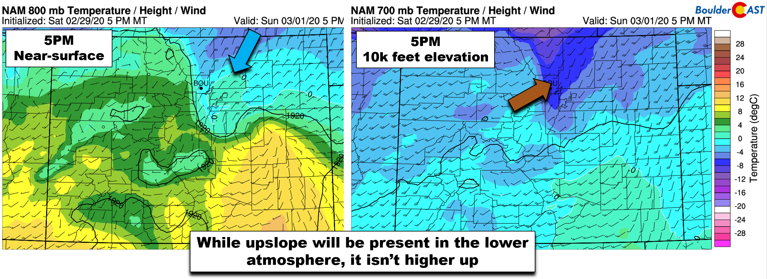
Temperatures may initially be too warm for snow as the precipitation begins. However, we are are expecting a quick change-over due to the vigorous nature of the cold front. The position of the front at 5:00 PM from two different models is shown below.

The latest timeline suggests a brief chance of rain/snow showers after about 3:00 PM this afternoon. Any mix of rain will then switch to snow in most areas rapidly, likely before 6:00 PM. As the front passes, concentrated frontogenesis and an unstable atmosphere will combine to support pockets of heavy snow across the Front Range within a few hours of the change-over. We’re slightly concerned about the potential for deep convective showers which could support some thundersnow across the area. The HRRR model has predicted CAPE values above 350 J/kg over the higher terrain of the Foothills and Palmer Divide by late afternoon. These are the areas most likely to hear a few rumbles of thunder with their snow today. However, it wouldn’t take much for the cells that form across the higher terrain to spread across the Denver Metro area, too.
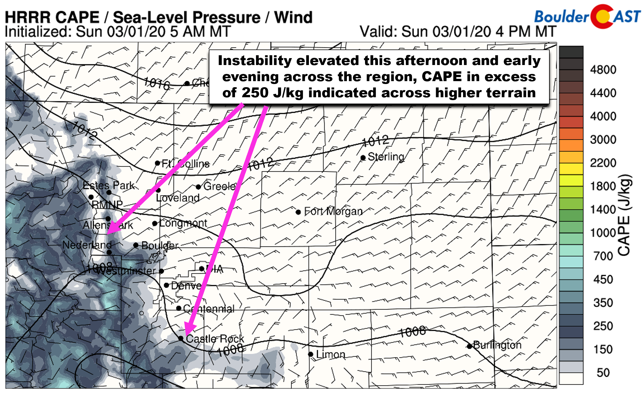
HRRR CAPE forecast for Sunday early-evening.
Snowfall rates in these convective pockets of near 2″ per hour are expected compliments of giant snowflakes and copious moisture! It’s difficult to say exactly where these pockets of heavy snow and even thundersnow will blossom this evening, but high-resolution models seem to be targeting areas near and south of Interstate 70. Truthfully though, we don’t trust this guidance all that much; anyone in the Front Range could and probably will see at least some brief heavier snow this evening.

HRRR model simulated radar animation for 7:00PM this evening showing very heavy snow across the Metro area
Finally, we do want to mention that upslope isn’t a major factor with tonight’s snow event. It will be somewhat shallow but favorable from a northeast direction. We’re not expecting any major enhancement due to this. The primary mechanism for snow will be the front itself and associated convection, but of course the upslope will be aiding in the background.
As the evening grows old, the forcing will dissipate and we expect snow to lessen in intensity and slowly wind down overnight. The most intense snow action will occur during the middle to late-evening hours, with light snow likely to linger into the morning on Monday.
Snowfall amounts & impacts
We’re seeing general agreement in global models for about 0.2 to 0.4″ of liquid across the Metro area with this system. Considering there may be a small period of rain followed by wet snow, this would equate to snowfall amounts of 1-4″ for the entire area. However, due to the possibility of embedded pockets of very heavy snow Sunday evening, some areas may reach amounts closer to 4-8″, though as mentioned earlier, it is difficult to say exactly where this will be. It’s probably going to be near and south of Interstate 70 somewhere. We’re really rooting for some thundersnow; it’s definitely a rarity in our area!
Our snowfall forecast map for snow falling Sunday evening into Monday morning is shown below.
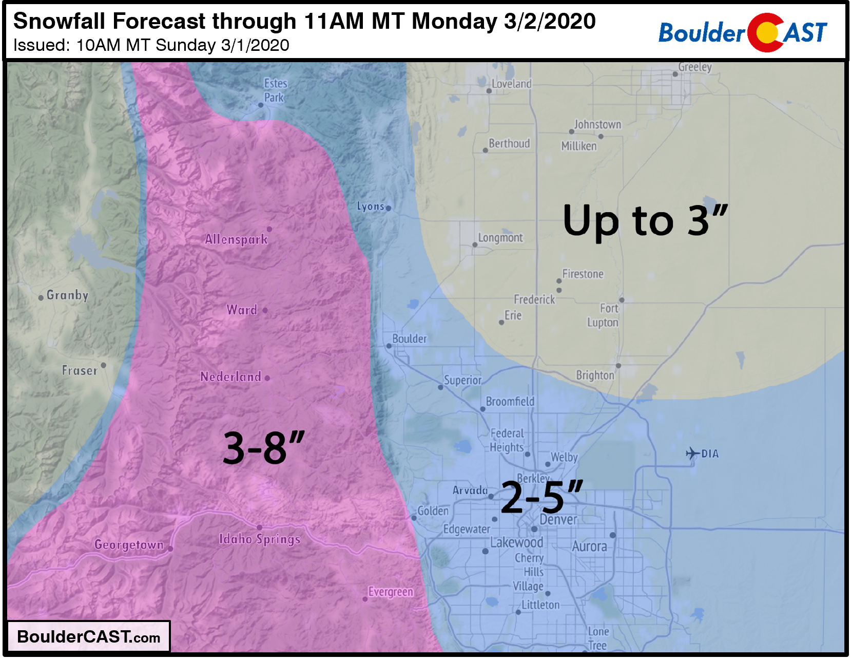
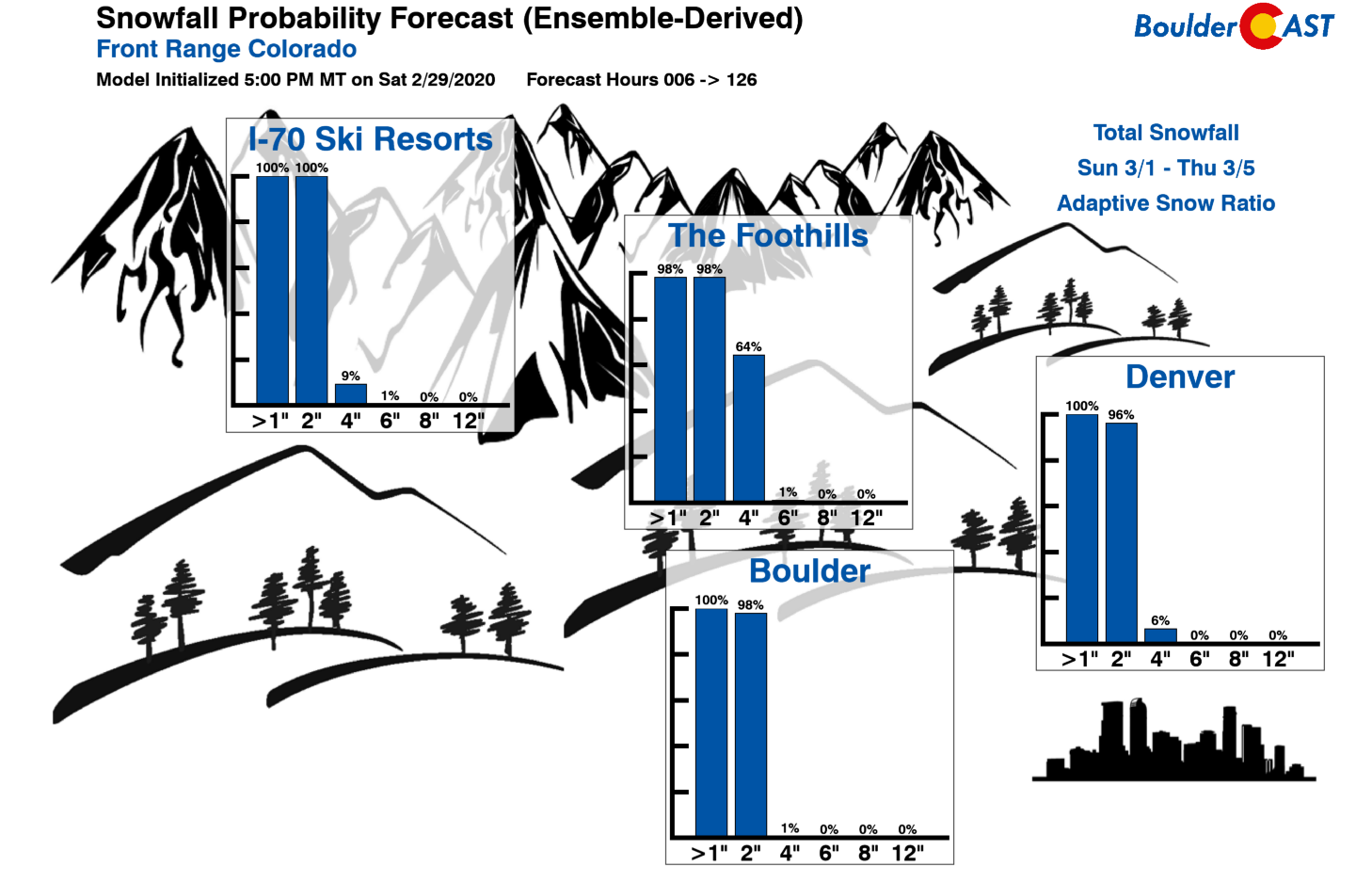
If you’re a gambler, check out our latest Snowfall Probability Charts. They indicate a near 100% chance of reaching 2″ in Boulder and Denver, but low odds of exceeding 4″. With the potential for heavy snow higher than usual, we’re not liking those odds.
Road temperatures near the onset of the snow will be quite warm, so initially roads will stay just wet. However as heavy wet snow begins and temperatures drop into the 20’s, road surfaces will become slick, icy, and snow-packed. Be careful traveling overnight (especially in those convective snow pockets!), and watch for residual impacts for your Monday morning commute. Winter Weather Advisories are posted for the entire Denver Metro area and higher elevations.
Following the snow, things look to quiet down and warm up considerably for the first week of meteorological spring! About time right? We’ll take a look at this and more in our weekly outlook tomorrow, so please do subscribe or check back then. Have a good rest of the weekend!
Help support our team of Front Range forecasters by joining BoulderCAST Premium. We talk Boulder and Denver weather every single day. Sign up now to get access to our daily forecast discussions each morning, complete six-day skiing and hiking forecasts powered by machine learning, first-class access to all our Colorado-centric high-resolution weather graphics, bonus storm updates and much more! Or not, we just appreciate your readership!

Subscribe to receive email notifications for BoulderCAST updates:
We respect your privacy. You can unsubscribe at any time.
.
Spread the word, share the BoulderCAST snow forecast!


You must be logged in to post a comment.