Paradoxically, the last day of winter will feel like spring and the first day of spring will be filled with heavy blowing snow. The Front Range will transition from warm and sunny weather Wednesday afternoon quickly to blizzard-like conditions on Thursday. However, the forecast remains a steep challenge with a combination of several factors likely to limit overall snow accumulation across the Denver Metro area, despite a deluge of liquid expected. We discuss the latest forecast, including our concerns about the wintry aspects of the storm and how much snowfall to expect.
PREMIUM UPDATE (8:00 AM Thu 03/19/20): We take a look at the impressive satellite imagery and observations this morning across the Denver Metro area and discuss our lingering concerns with those pesky springtime temperatures. Click HERE to read.
Key Forecast Highlights:
- A potent, moisture-rich spring storm will impact the Front Range on Thursday
- Rain will change to heavy snow during the late morning hours with snow continuing through the rest of the day
- 1 to 2″ of liquid is likely (rain and melted snow equivalent), a significant amount for our area
- A handful of factors, including above freezing air temperatures, will limit snowfall accumulation
- Heavy snow and strong winds will create near-blizzard conditions Thursday afternoon and evening
- Our team’s current forecast calls for 3-8″ of snow in Boulder and Denver, but confidence is low
General Discussion:
Hey! What do you know? The winter storm we warned you about on Monday is coming to fruition, though it may not seem that way looking outside. The sun is shining with temperatures soaring into the middle 60’s this afternoon.
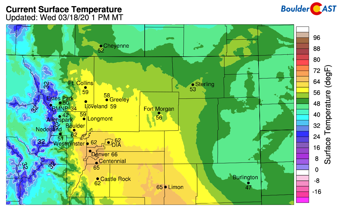
Current temperatures across the Front Range as of 1PM Wednesday
Conditions will deteriorate rapidly tonight into Thursday morning with quite the onslaught of wet and snowy weather expected over the next the next 36 hours. A messy medley of low pressure systems currently sits across the western United States (see below). The southern-most low pressure in the mix will sweep northeastward tonight and push across Colorado during the day the Thursday while the dominant parent low remains nearly stationary across Nevada into the upcoming weekend.

GFS 500mb vorticity map for Wednesday afternoon showing our approaching storm located over Baja California
GOES-West has a great look from space at both storm systems this afternoon:
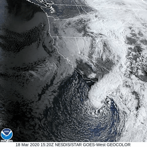
GOES-West visible geocolor satellite animation from Wednesday morning
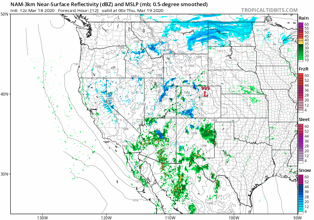
Most weather models tend to agree on the track of the storm generally ending up in east-central Colorado by mid-day Thursday, a favorable one for the Front Range. The associated surface low will produce an extended period of somewhat favorable upslope for our area coinciding with strong lift from the large-scale system. The high-resolution NAM model simulated radar animation below shows the low pressure progressing from the Desert Southwest, across Colorado and into the Midwest by Friday with rain changing to snow across the Front Range.
This storm’s initial path very far south into portions of Mexico before heading towards Colorado will allow it to tap into deep subtropical moisture. This moisture will be pumping northward and wrap back southwest into Colorado during the day Thursday along a moist conveyor belt. This is shown below.

NAM 700mb theta-e and wind forecast for Thursday morning. Theta-e is a good proxy for warm and moist air which is shown to be wrapping into the storm system
The result will be an hefty deluge of liquid across the Front Range on Thursday. There is strong model agreement for at least 0.75″ of liquid for everyone, with most areas poised to pick up an 1″ or more. High-end model solutions indicate that up to 2″ is possible, though this is probably rooted in overly-optimistic convective rain/snow aspirations.
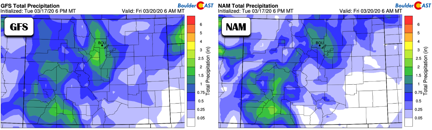
Total precipitation forecasts from the GFS (left) and NAM (right) models through Friday morning. 1″+ of liquid is indicated for the Metro area by both models.
These impressive liquid forecasts have been consistent for a few days now in the models. With a likewise consensus from the ensembles, our confidence is high on the BIG and SOGGY potential for Thursday’s storm.

Clearly a big event, but how much of it will be snow?
Well, that’s the easy part of the forecast out of the way. As is frequently the case this time of year, the challenge will be ironing out potential snow amounts…and let us say this is a monstrous task with this storm especially! As we’ve seen, there’s going to be a lot of warm and moist air wrapping back into northeast Colorado. The northerly push on the backside of the surface low isn’t going to be all that cold (see four panel graphic below). Precipitation will certainly begin as a chilly rain across the lower elevations Thursday morning. That is for sure. However, we do expect cold enough air aloft to eventually work into the area to turn rain to snow for everyone. The timing of this change-over is not 100% clear right now, but it looks to happen sometime during the late morning into mid-day on Thursday.

NAM near-surface 800mb temperature and wind forecast maps for Thursday at four times. Cool, but not cold air filters into the Front Range from the north
Even after the change-over to snow, surface temperatures really won’t get that cold until evening. We may struggle to drop below the middle 30’s during the day Thursday. Best case scenario: we get down to around the freezing mark or just above.
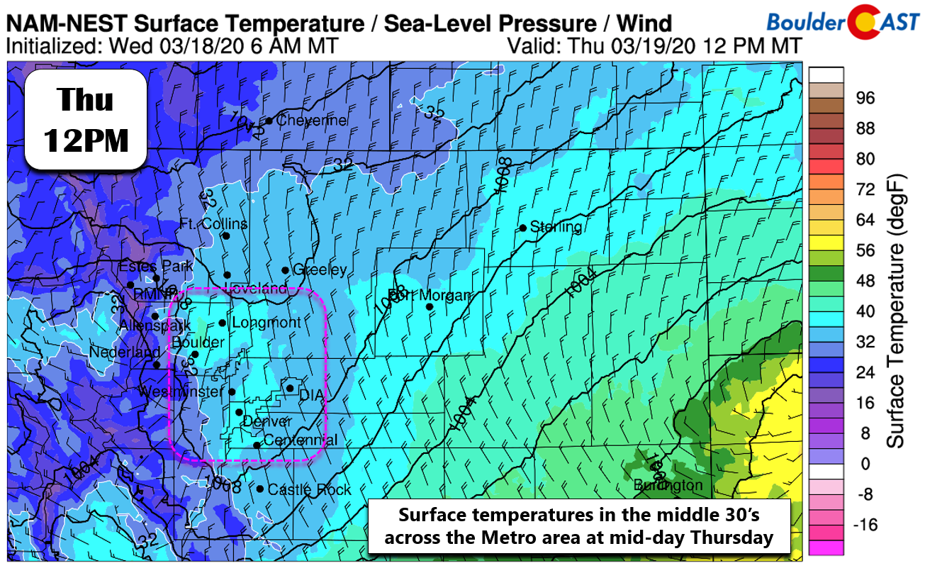
Temperatures struggle to cool Thursday, only reaching 33-37°F in most areas.
Considering the heaviest precipitation will be falling from about mid-morning Thursday into the late afternoon, the impact of the above freezing surface temperatures will be exacerbated by the mid-March sun. Even shining through thick clouds, spring-time solar radiation is strong enough to help melt prospective accumulating snow. This is further complicated by the warm ground temperatures. Remember, the very day before was in the 60’s with sunny skies.

As you can see, Mother Nature has left us between a rock and a hard place. There’s so much liquid potential with this event that any small deviation towards colder temperatures could have major implications on snow totals across the Denver Metro area. We think the odds of this are fairly low given the daylight timing of the storm. It’s still a concern we do have and will be closely monitoring in the hours leading up the change-over for potential forecast modifications. As it stands now, however, we’re going to hedge towards a somewhat more conservative slushy snowfall forecast for the Boulder/Denver area.
Here’s the latest timeline of events we expect to unfold:
- Wednesday will truly feel like spring! Expect sunny skies early with increasing clouds and only a 10% chance of a late afternoon/evening rain shower. High temperatures push into the middle 60’s.
- Light drizzle and fog may develop after midnight especially west of Interstate 25, but most of the precipitation holds off until sunrise Thursday. Temperatures Thursday morning begin in the 40’s but fall consistently thereafter.
- Things really get cranking during the morning hours Thursday with widespread moderate rain over-taking the area and snow in the higher Foothills. Snow levels will be falling and eventually that rain will change to heavy wet snow across the lower elevations as well. Our current thinking on the change-over timing is between 9AM and 1PM on Thursday.
- From the initial change-over into the afternoon, snow could be very intense at times with snowfall rates of 2″ per hour. As such, watch for slushy and snow-covered roadways, despite the milder temperatures.
- The wind will ramp up as the day wears on with blizzard-like conditions expected with gusts above 35 MPH. The worst of the wind will be east of Interstate 25. The wind will be less intense in the immediate Metro area, but blowing snow and reduced visibility at times is expected.
- Temperatures continue to slowly drop through the afternoon and evening. Light snowfall will linger into the evening, winding down fully around midnight of slightly after for everyone.
- Highs on Friday return to the 30’s with cloud cover sticking around and another chance of scattered convective snow showers later in the day. Additional accumulations are expected to be minimal, 1-3″ at most, but probably less. We haven’t had much time to take a look are this potential “round two” yet.
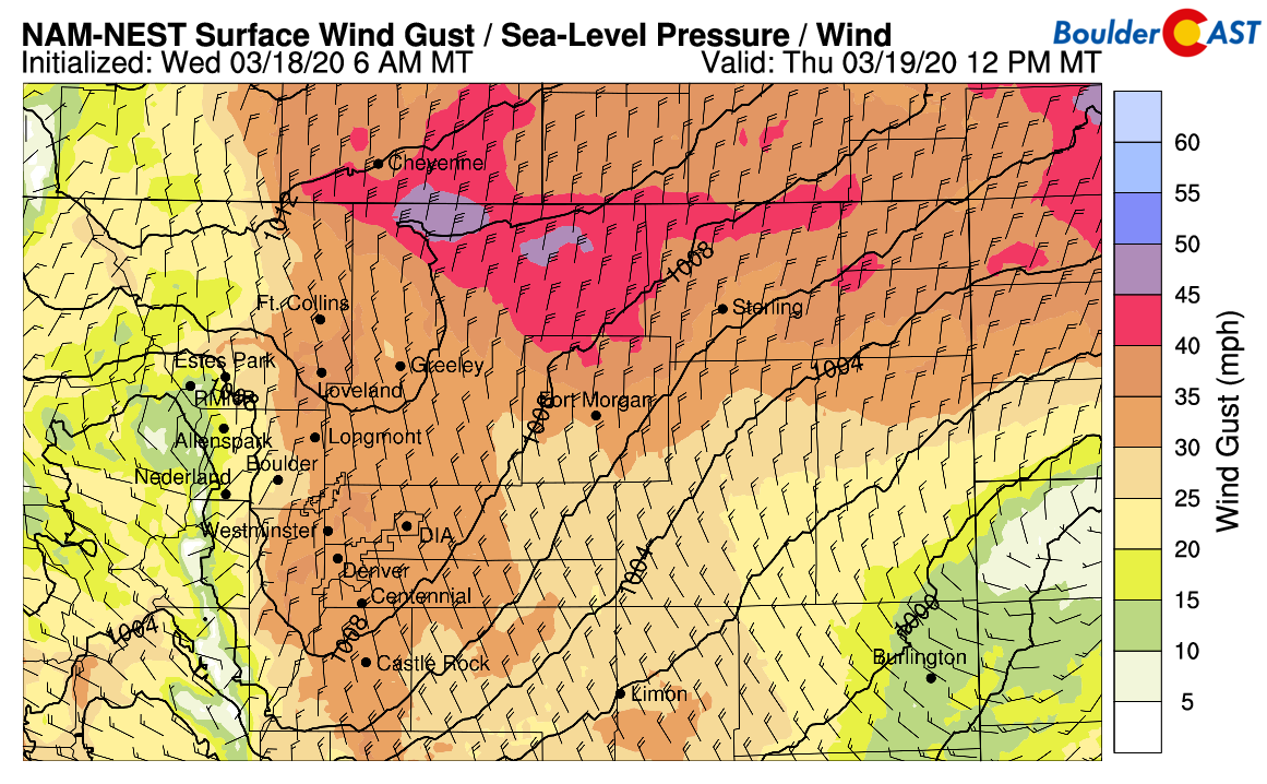
NAM-Nest wind gust forecast for Thursday afternoon. Blizzard like conditions will be possible with blowing snow, especially north and east of Denver
Finally, let’s talk about the elephant in the room: snowfall amounts. Our highest confidence in accumulation is across the Mountains and higher Foothills above 7500 feet where it will be all snow falling with temperatures plenty cold enough to sustain accumulation during the day Thursday. These areas can expect 10-18″. Overall forecast confidence decreases going down in elevation, with amounts of 6-12″ in the lower Foothills (6000-7500 feet). Last but certainly not least, the bulk of the Boulder and Denver Metro area can expect between 3-8″ of slushy snow. There will be slightly lower amounts in the northern tier due to warming/drying effects of downslope from the Cheyenne Ridge. Keep in mind that there will be a lot of melting and what remains at the end of the day may be on the lower end of that range. Remember, we are forecasting snow accumulation, not depth.
Our snowfall forecast map for the event is shown below. This covers snow falling through Thursday night.

With the increased margin of error, especially across the populous lower elevations of the Metro area, we’ll continue to monitor the developing situation closely and provide any updates as needed. We foresee supermarket shelves becoming even more barren soon considering the threat of spring snow heading our way compounding panic over the spreading virus.
Get out there and enjoy the last day of winter (with social distancing)…it sure will be a spring-like one!
Help support our team of Front Range forecasters by joining BoulderCAST Premium. We talk Boulder and Denver weather every single day. Sign up now to get access to our daily forecast discussions each morning, complete six-day skiing and hiking forecasts powered by machine learning, first-class access to all our Colorado-centric high-resolution weather graphics, bonus storm updates and much more! Or not, we just appreciate your readership!

.
Spread the word, share the BoulderCAST snow forecast!


You must be logged in to post a comment.