As advertised earlier in the week, wet weather is set to invade the region this afternoon and linger through the day Friday as a strong storm plows across Colorado. While the lower elevations will see all rain, potentially lots of rain, the Foothills and Mountains will be cold enough for snow. Read on for our complete forecast covering the next two days and the upcoming weekend.
Let it……Rain?
When we posted our weekly outlook on Monday, models were forecasting a closed-low to form in southeast Colorado Friday morning, a set-up that would provide ideal conditions for a Front Range upslope event. The map below is from a GFS model run initialized this past Sunday, showing the 500 mb circulation just south of Denver.
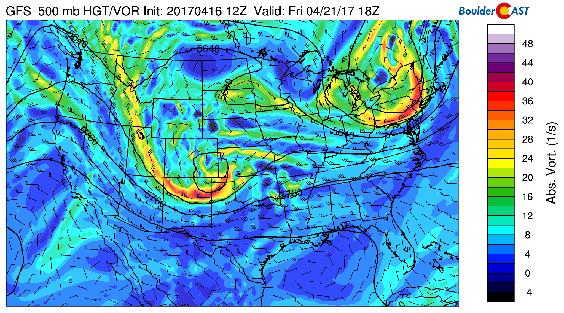
GFS 500 mb vorticity map that was produced this past Sunday showing a closed-low in southeast Colorado. Compare this to the one below.
We expressed our concerns that the above scenario playing out was questionable at best. Sure enough, four days later, the models have backed-off from their closed-low solution (actually they just delay it until the storm is well to the east in Kansas). In the 500 mb vorticity map below, the latest one from the GFS, we see just a strong open-wave across Colorado instead. Those lying models!
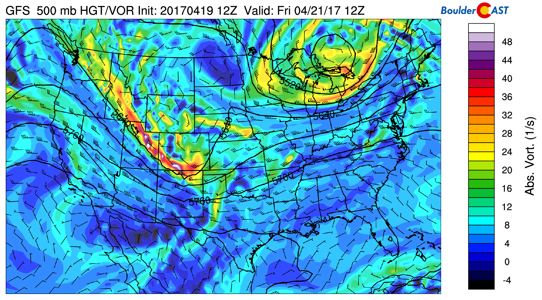
GFS 500 mb vorticity map for Friday morning showing the storm moving across Colorado.
The expected results of this change would be:
- A quicker-moving storm (less overall precip)
- Less cold air to support snow (more rain)
The last point is definitely true (more on this later)…
…the first, we’re not so sure…
As we mentioned earlier, this will be an all RAIN event for the Plains and likely a good chunk of the Foothills as well. Instead of the storm driving low-level winds from the northeast (cool upslope), they will keep their southerly component throughout much of the event. This scenario is almost always too warm to support snow, especially in late April. Despite this, southeasterly flow is still upslope for the region, and this direction brings with it the benefit of added Gulf of Mexico moisture. The moisture anomaly forecast map below for Friday morning shows a developing surface low in southeast Colorado, along with a faucet of moisture heading into Denver and Boulder.
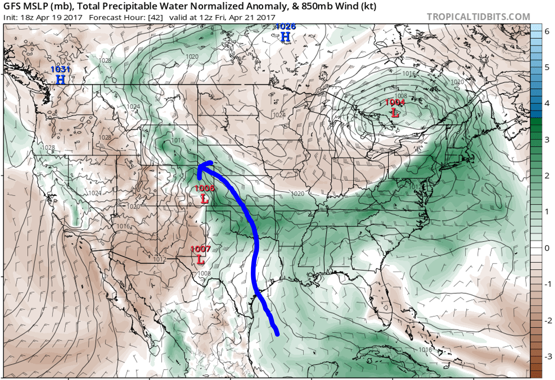
GFS pressure and moisture anomaly map for Friday morning showing the tap of Gulf Moisture flowing into Colorado.
TIMELINE…..We expect the effects of the approaching trough to begin to be felt this afternoon with the development of widespread showers. Cooling in the mid-levels and relatively warm air at the surface (low 60’s) could make things unstable enough for a few lightning strikes as well. Nothing screams SPRING like the roar of thunder! This lift will persist into the evening hours and late into the night, at which point northeasterly upslope will take over and keep at least the chance of light precipitation lingering into Friday night.
AMOUNTS……The GFS model ensemble plumes for total liquid precipitation are shown below. The mean of all 20 members is 1.04″ in Denver! Quite the substantial storm! But wait a second…
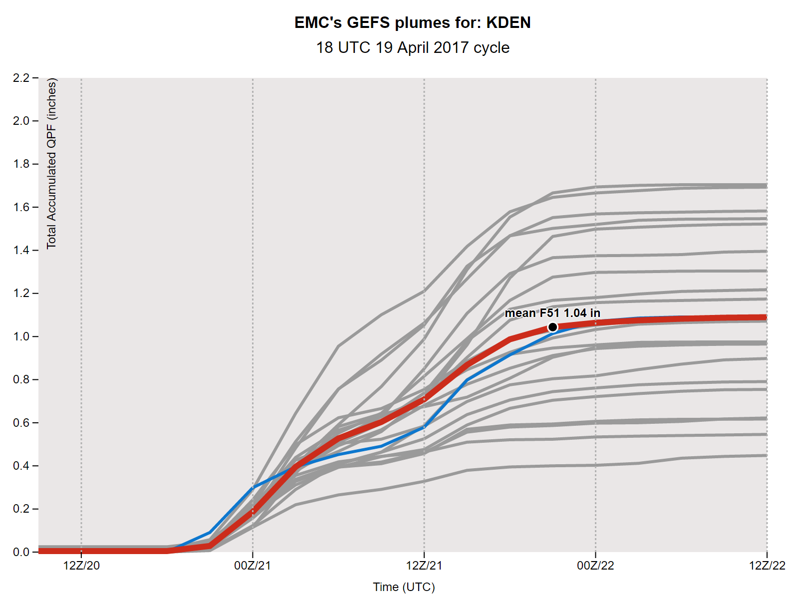
It’s a bit worrying that the spread is so large and that there isn’t even any true outliers. For reference, here’s a graph that shows much less spread and lends to a more confident forecast… the same plumes for the same event, but for Cheyenne, Wyoming instead…
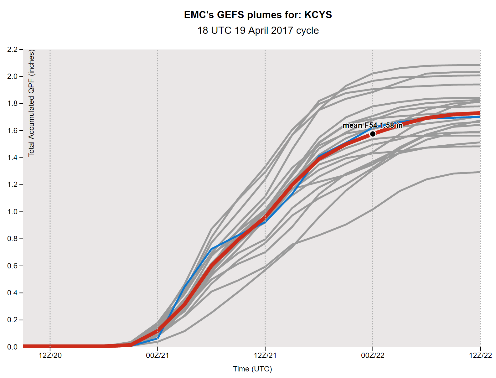
Sure, the mean is higher at 1.58″, but there’s barely any spread. At least, far less than for Denver. This tells us that there are a lot of atmospheric pieces that are somewhat marginal for Denver for this storm. However, it could also just be the lower resolution GFS being confused by the convective precipitation Thursday afternoon and evening. You can’t really rely on the plumes if there is thunder involved.
Other models tend to support totals towards the bottom half of the GFS ensemble’s spread for Denver. Both the high and low(er) resolution NAM models predict 0.5 to 1.0″ of rain for the Metro area. We think this will be the “sweet spot” where most locations end up for rain. Nonetheless, with the potential for a few thunderstorms tossed into the mix, localized areas may blow past this range.
High temperatures Friday will be fighting an uphill battle, trying ever-so-hard to get out of the 40’s, but likely not succeeding. Overcast skies, drizzle, fog, and mist are all on tap for the Metro Area. Hey, look at the bright side…at least it will be Friday!
Will there be any snow?
We haven’t forgot about the obligatory snow discussion! Truth is, things are just too warm… Earlier this week, the storm was showing hints the colder air may be around. However, with the cut-off low no longer on the table (at least in Colorado), the colder air is gone as well. The 800 mb temperature map for Friday evening (shown below) shows the colder air confined well to our east in Kansas. At the 800 mb level, to support snow on the Plains, we need to see temperatures close to zero degrees (Celsius). Instead, temperatures are near 3 degrees. And this is at the tail-end of the event; it’s even warmer when a bulk of the precipitation is actually falling.
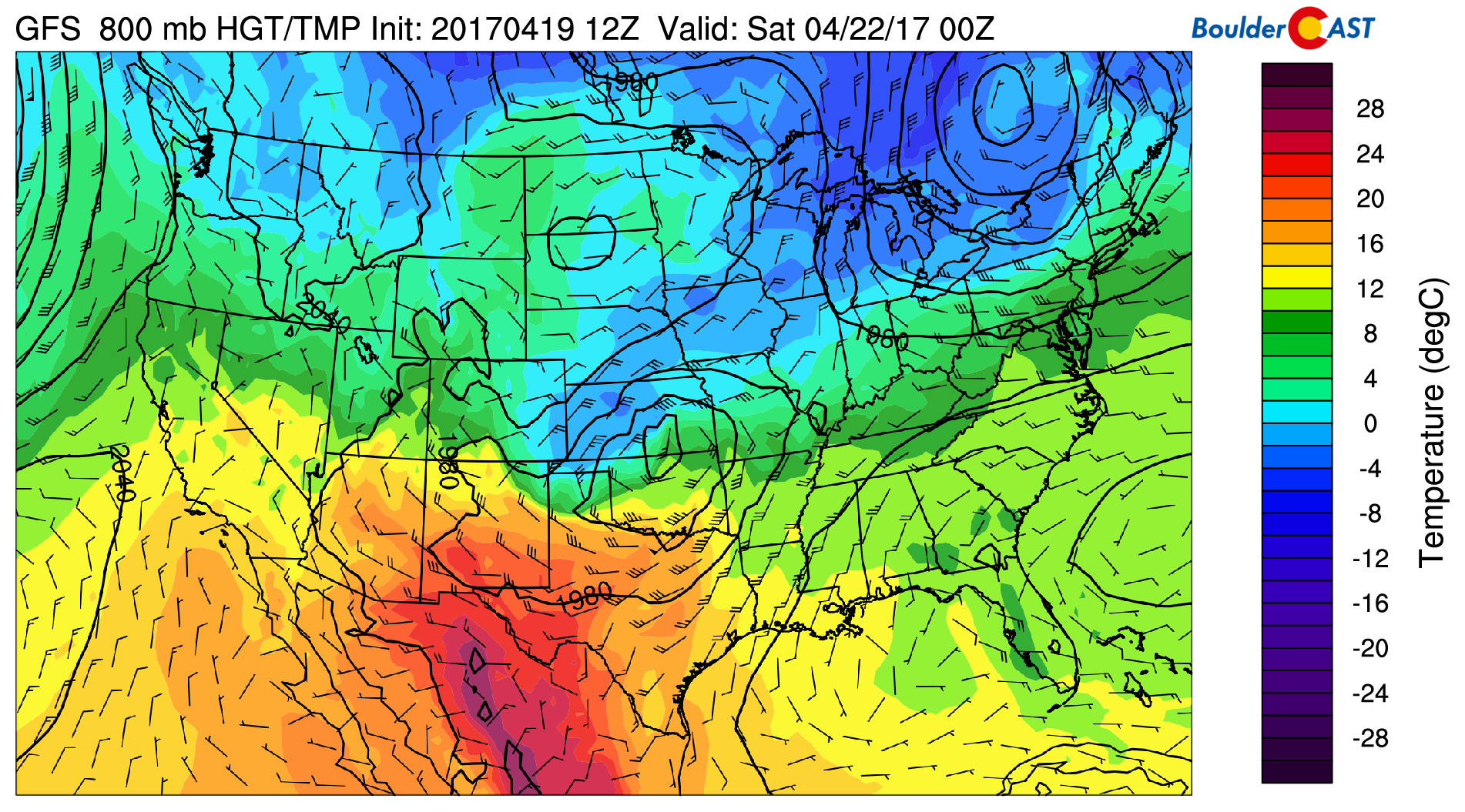
GFS 800 mb temperature and wind forecast for Friday evening. Too warm for snow on the Plains as the colder air stays to our east.
Snow levels will be high this afternoon, well above 9,000 feet. However, cooler air will filter in and they will slowly be falling through the evening and overnight towards 6,500 feet by sunrise Friday morning.
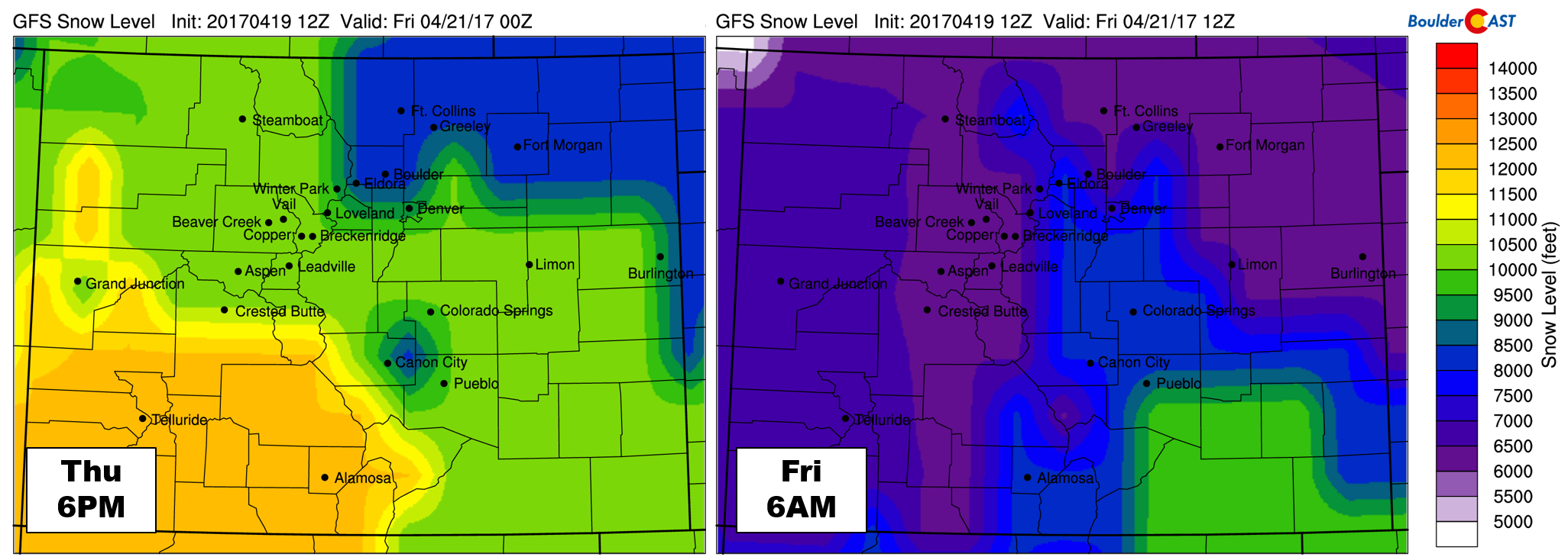
GFS forecast derived snow level for Thursday evening (left) and Friday morning (right).
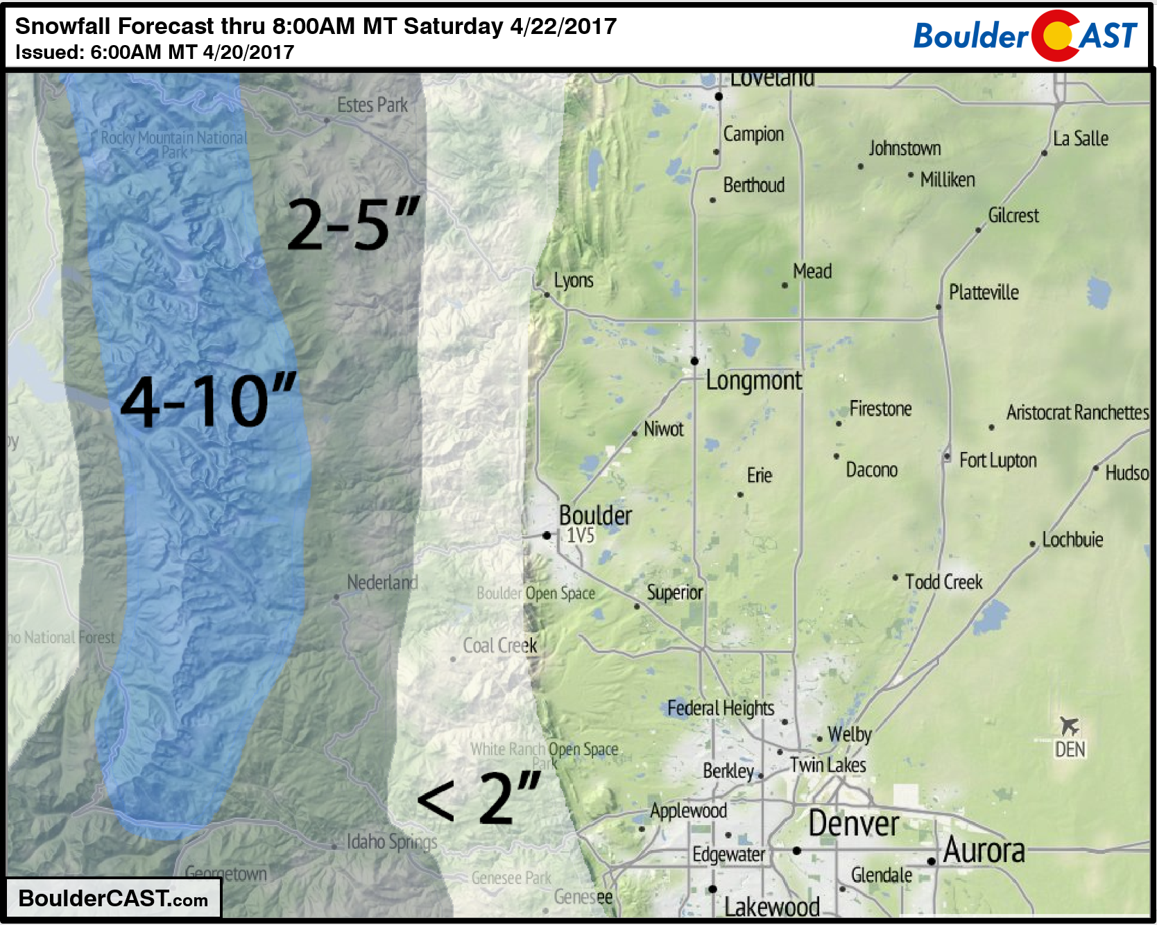
The toughest part of the forecast will be the overlap between the decreasing temperatures and the heavier precipitation. Though the snow levels will remain low through the day Friday (likely between 6,500 and 7,500 feet), the storm will be winding down with only weak upslope left in its wake. This makes for a tricky forecast at all elevations! Our best, broad-brush guess is that areas above about 9,000 feet could see 4 to 10″. Elevations between 7,000 and 9,000 feet are more uncertain, but we think 2-5″ is possible. For Foothills locations below 7,000 feet, you may not see any snow at all. However, there is a chance, especially Friday evening when the coldest air will be around, so we’ll go with less than 2″ there.
Our snowfall forecast map for the event is shown below.
THE WEEKEND & BEYOND……After surviving two days of ugly weather, things quiet down for the weekend. Expect sunshine to return by Saturday afternoon with a high near 60 degrees and then near 70 degrees Sunday! Things are already looking unsettled for next week, with two potential storms hitting the BoulderCAST radar. The more the better, we say!
As always, thanks for reading!
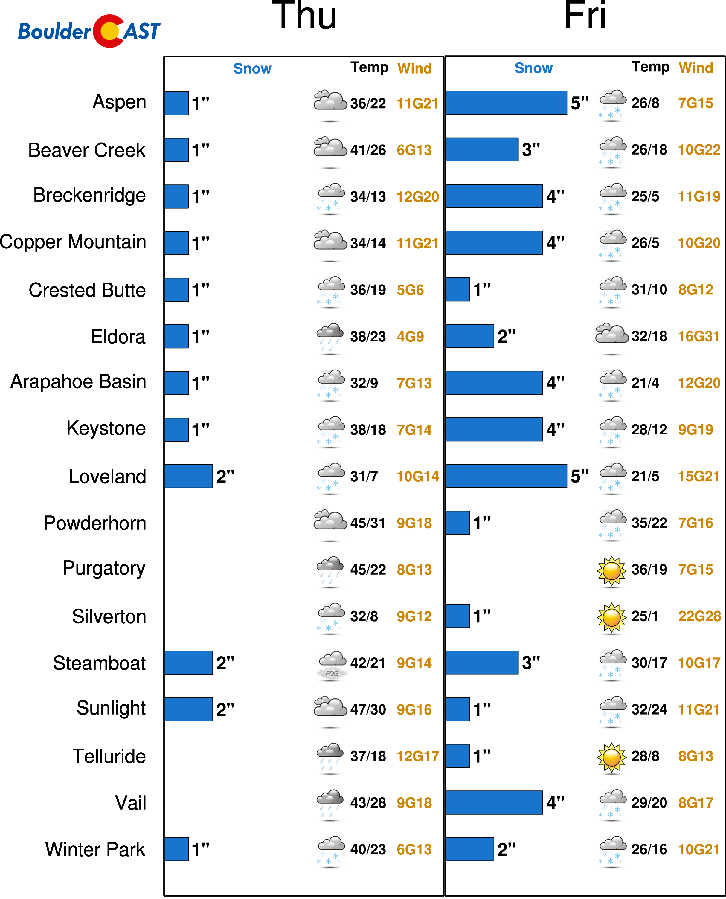
P.S. This will not be a big storm for the ski resorts by any stretch of the imagination. We’re looking at 3-6″ across the board. Keep in mind, only a handful of places are even still open (thanks to the warm/dry February and March). See our PowderCAST page for full details.
.


