The third Spring storm in just the last seven days is knocking on our door. While fairly similar to the last two events, this one will have colder air to work with, and therefore, should produce some snow for everyone. In our initial forecast, we discuss timing, preliminary snow expectations, and lingering model inconsistencies.
Beneficial moisture for all
Over the last six days, two similar springtime storms have combined to produce the first widespread precipitation across the Front Range since late February. Boulder has recorded nearly one inch of liquid from the two events, with Denver not far behind at 0.78″. Areas southeast of Denver and in the Foothills were closer to 1.50″. Of course, these totals don’t bring us anywhere near normal for March, but hey, the parched vegetation isn’t complaining!
The last storm, which occurred Tuesday into Wednesday, was a mostly rain event for the Metro area. As our forecast pointed out, the Foothills were the winners this time around for snow. Anywhere from 3 to 13″ fell above 6,500 feet. The only accumulating white stuff on the Plains was in Aurora, and just a measly half inch at that.
Shown below is our original forecast map created early Tuesday morning. The observed storm totals per location are contained in boxes. Green ones indicate that the observed snowfall was within one inch of the given forecast range, while red was outside the scope of our forecast.
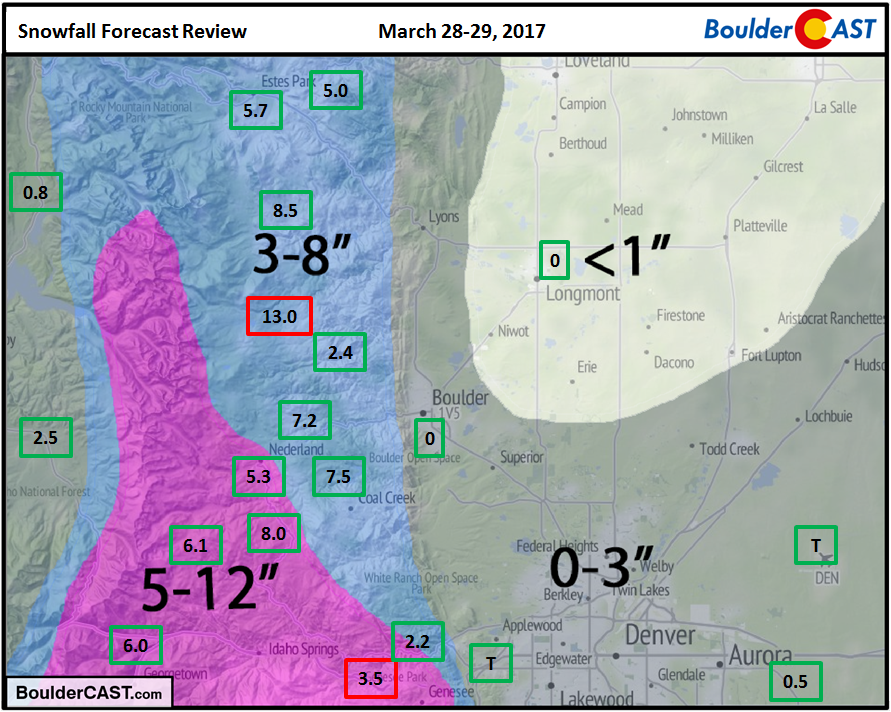
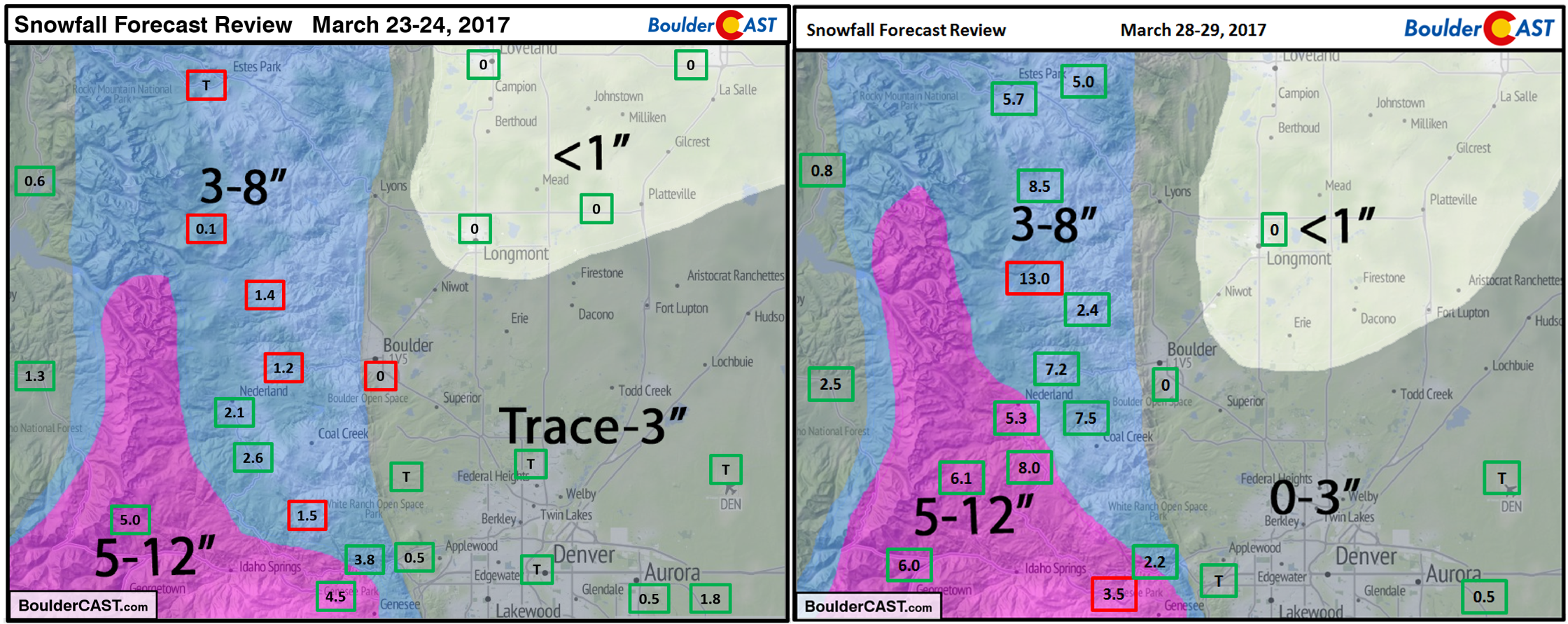
As we have reiterated this week (and last week), the models have been all over the place with these last two systems, especially in the final few runs leading up to each precipitation event. Huge discrepancies in track, QPF (forecast liquid precipitation), and temperatures were more prevalent that any recent storm we can recall. Confidence was low, and the bust potential was elevated. For this reason, we used the 0-3″ snowfall range across most of the Metro area both times. In fact, you’ll be hard pressed to find much difference between our snowfall forecast map for last week’s storm (below on left) and this week’s storm (below on right). The two weather systems were so similar, we just recycled our map (just kidding….wait, did we?).
Despite snow entering the discussion over the last week, Boulder will conclude March (our snowiest month on average, by the way) with NO measurable snowfall. This has only happened one other time in the last century. Denver will meet the same snow-less fate as well. Marked by record-setting heat, plenty of wind, wildfires, and no snow, yes, March 2017 has been a strange month…
The upcoming forecast does have us wondering, though. If April showers bring May flowers, what does April snow give rise to?
April to begin with a snowy bang?
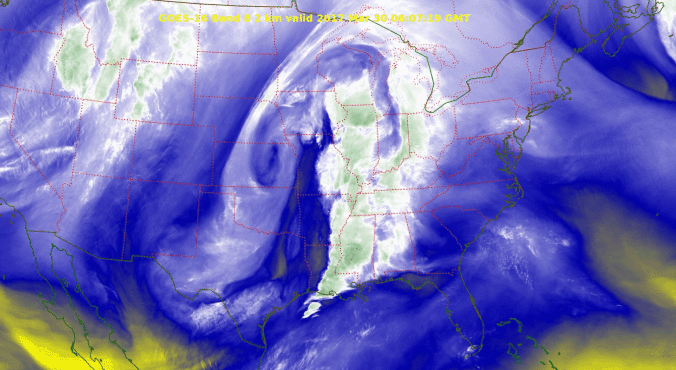
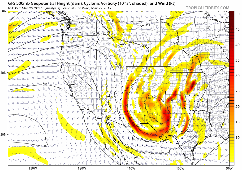
As quickly as our last storm exits to the east, another one in the pipeline will move into the Four Corners region for Friday, bringing with it yet another chance of precipitation to the Front Range. Remember that pattern shift we had been foreshadowing for weeks? We’re smack in the middle of it now! The 500 mb GFS model vorticity animation below shows the fleeting storm and next storm knocking on our door tomorrow…
GFS 500 mb vorticity and height animation through Sunday, showing the storm’s arrival.
In our weekly outlook posted on Monday (see the “Round #2” section), we expressed our concern that this late-week system looked stronger and colder than either of the prior two storms. Four days later, this still looks to be the case. Just about all the models are on-board for another potent upslope event for the region, this time including cold enough air to support snow for just about everyone. Both the GFS and NAM have snow levels already encompassing all of the Plains by midnight (or sooner) Friday night.
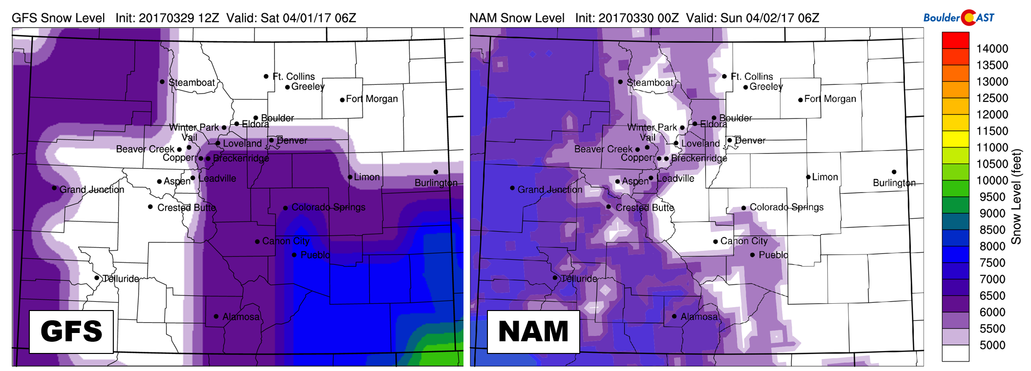
GFS (left) and NAM (right) model-derived snow level for Saturday night at midnight. There is good agreement between both models that snow will mix in/change over on the Plains for this storm.
Let’s not get ahead of ourselves. Yes, it should be cold enough for snow, but will the dynamics be there to ring the moisture out of the atmosphere across the Front Range? Right now, the best we can say is..”probably, yes”. As has been the case lately, model variations are huge. We’d like to enter into evidence the latest GFS (left) and NAM (right) forecast precipitation totals through Sunday morning….
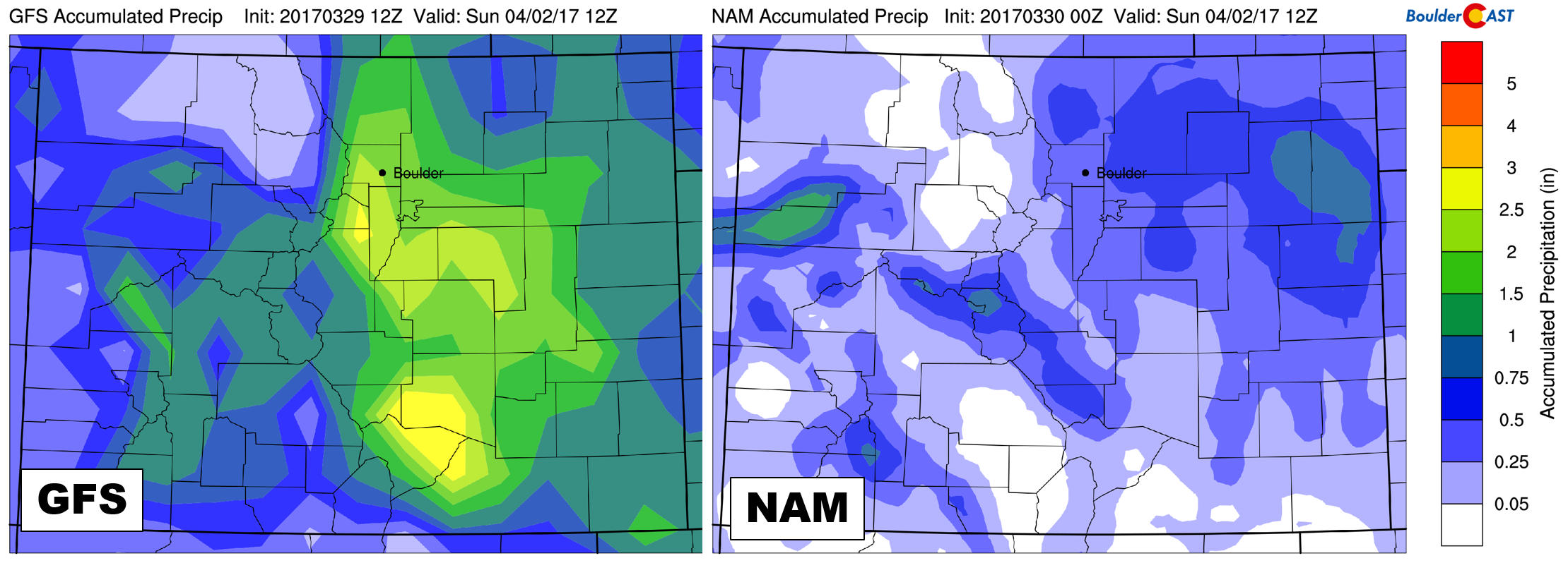
Total accumulated precipitation through Sunday morning from the GFS (left) and NAM (right) models. HUGE differences are apparent.
Yikes! It doesn’t get much more black and white than that. This huge difference is the result of each model producing entirely different scenarios. This storm is set to cut-off from the jet stream, a facet weather models notoriously have trouble resolving.
The NAM stalls the upper-low too far to our west, weakens it, then whips it northeastward across southern Colorado Saturday evening. Under this set-up, little to no upslope occurs and the storm sputters out before really even reaching eastern Colorado. On the contrary, the GFS brings the storm further east before stalling the system, and tracks it across extreme northern New Mexico slowly on Saturday. This provides ample deep and moist upslope right into Denver for a VERY long time. Not 2013 Boulder Flood long, but you get the point.
Combining the cold air represented by all the models, and the absurd 2 to 3″ of liquid forecast by the GFS, you might imagine its snow forecast is pretty gnarly. You’d be correct…
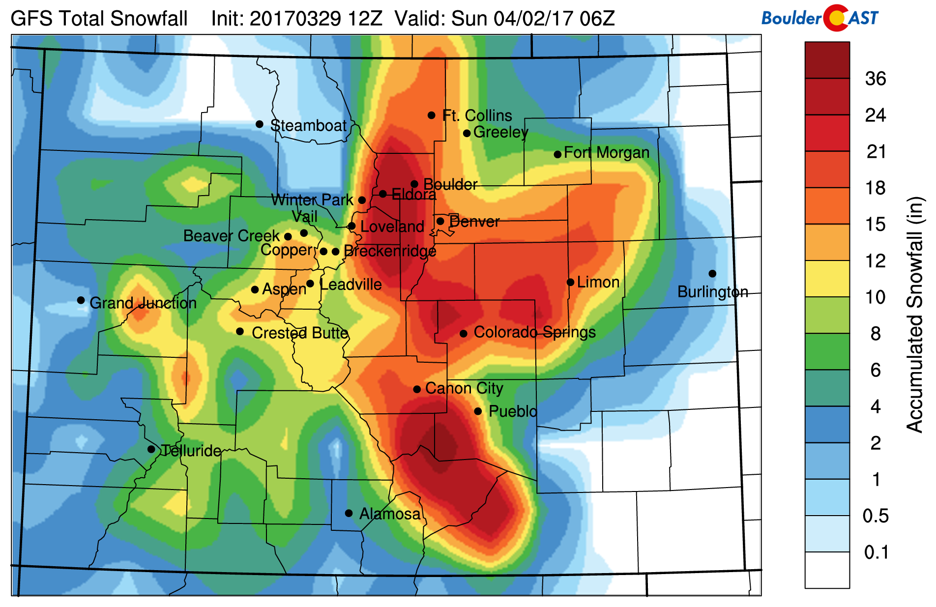
GFS snowfall forecast through Saturday night. We’re definitely not expecting this much snow! Just an example of the silly things models do sometimes…
The GFS has been out to lunch on the last two storms, and with this one being so similar again, it’s hard not to just disregard it altogether.
In all seriousness, here are some of our initial predictions for the storm. Keep in mind, nothing is set in stone, but confidence is increasing...
- We could see some spotty rain showers Thursday night, but things really get cranking Friday afternoon and evening as upslope settles in. Snow levels will quickly fall from around 7,500 mid-day Friday towards 5,500 by Friday evening.
- We’re finally fairly confident to say the change over to snow will happen for everyone, all the way down onto the Plains. This will likely occur around or before midnight Friday night. As has been the case of late, low-level northerly flow downsloping from the Cheyenne Ridge remains a concern for Niwot into Longmont (Rainmont?) and Loveland. A few extra degrees of warming could keep things mostly rain in these locations.
- Just like the past two storms, the southern track concerns us. It’s just a hair further south than we’d like to see. Boulder County may be on the fringe again.
- Depending on how much moisture we can squeeze out Friday night, heavy wet snow could be a concern. We may see a few power outages given the expansive foliage already in place.
- Precipitation could linger well into the day Saturday. It is expected it would turn back over to rain/snow or rain by late morning, however.
- Preliminary accumulation potential
- We’d be hard pressed to imagine a scenario where the Foothills above 6,000 feet don’t get at least 7-14″ of snow.
- Our best guess for lower elevation snow totals right now is 2-6″, with the best chance of accumulating snow being from 9PM Friday through 9AM Saturday. If somehow the other models start trending towards the GFS in the next day or so, all bets are off and we’re all in trouble.
Check back tomorrow morning for our final forecast, or follow us on Facebook or Twitter for our more frequent thoughts. Let it snow?!
.


