We’ve really been spoiled of late in regards to weather! Only a few raindrops have fallen in the last six weeks, with temperatures remaining warmer than normal on all but a handful of days. This changes on Saturday as a deep trough plows into the region, kicking the unending ridge of high pressure eastward. Cool and unsettled weather will linger well into next week. We’re also monitoring the potential for the first significant snowfall in the Mountains. We have a lot to discuss!
The leaves aren’t the only thing changing….
Global models are forecasting a magnificent shift in the PNA index to close out the month of September (see the red line below). A very negative PNA index typically correlates with cooler weather in Colorado during the fall months. We mentioned these potential changes in our outlook on Monday.
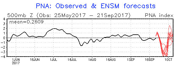
PNA analysis and 14-day forecast (NOAA CPC)
But is the PNA on-point?
Below is a current look at the middle of the atmosphere. The large ridge that soared Denver’s temperatures to near 90 degrees today is shifting eastward. Okay, sure… that’s fine…it was too hot anyways. We also have Jose and Maria still hanging out offshore to the East Coast. Yep, that’s all the media talks about these days. And finally, we have….wait… WHOA! What is that to our west…a trough you say? What is this “trough”?
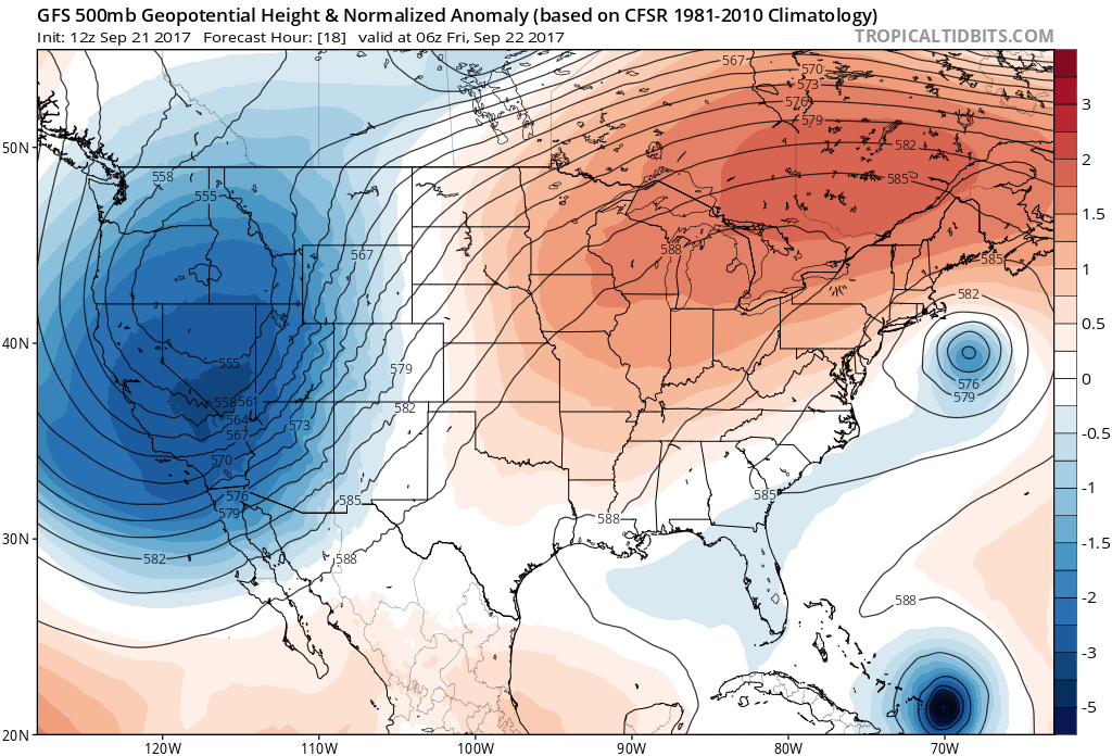
GFS 500mb height and anomaly for Thursday evening for the United States
All joking aside, we do finally have our first true autumn-like trough developing to our west! This trough is heading towards Colorado and is actually the most intense one in the entire Northern Hemisphere right now….
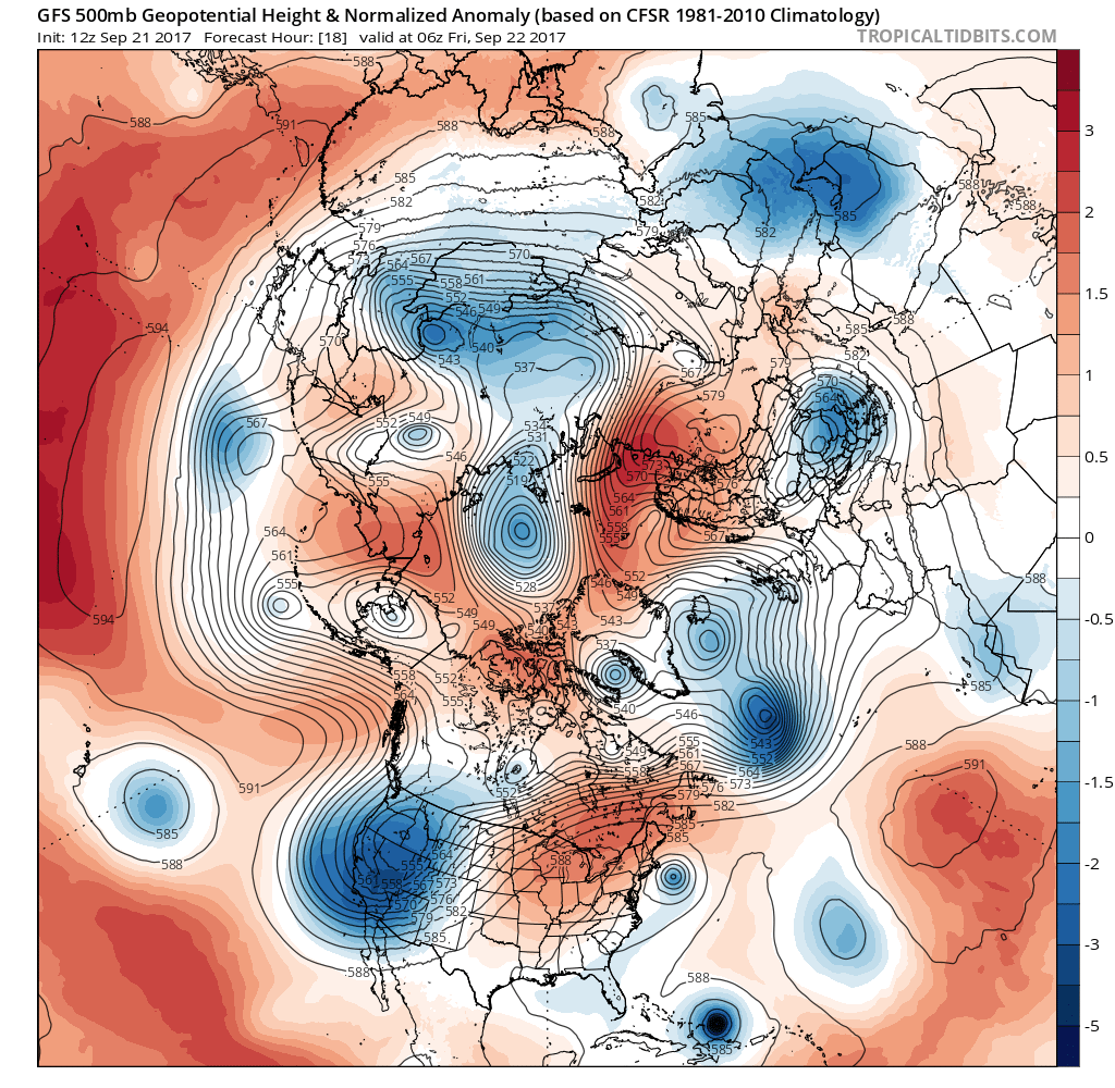
GFS 500mb height and anomaly for Thursday evening in the Northern Hemisphere
The 700 mb temperature map shows just how cold the air beneath the trough is (and also how warm it is today in Colorado ahead of the trough).
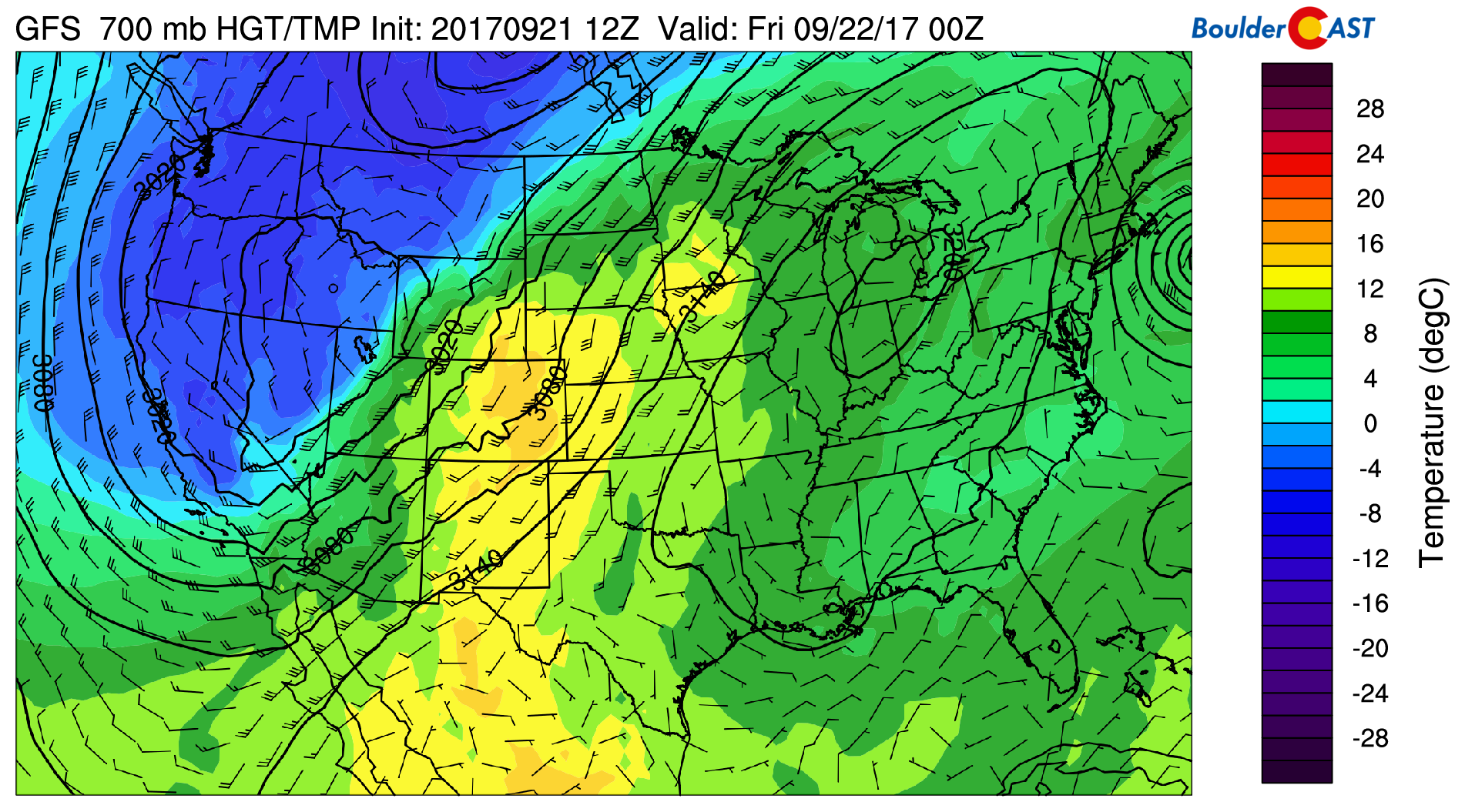
Thursday’s 700 mb temperature map showing the cold air headed our way
The front edge of the trough can easily be seen on the current visible satellite loop from GOES-16…
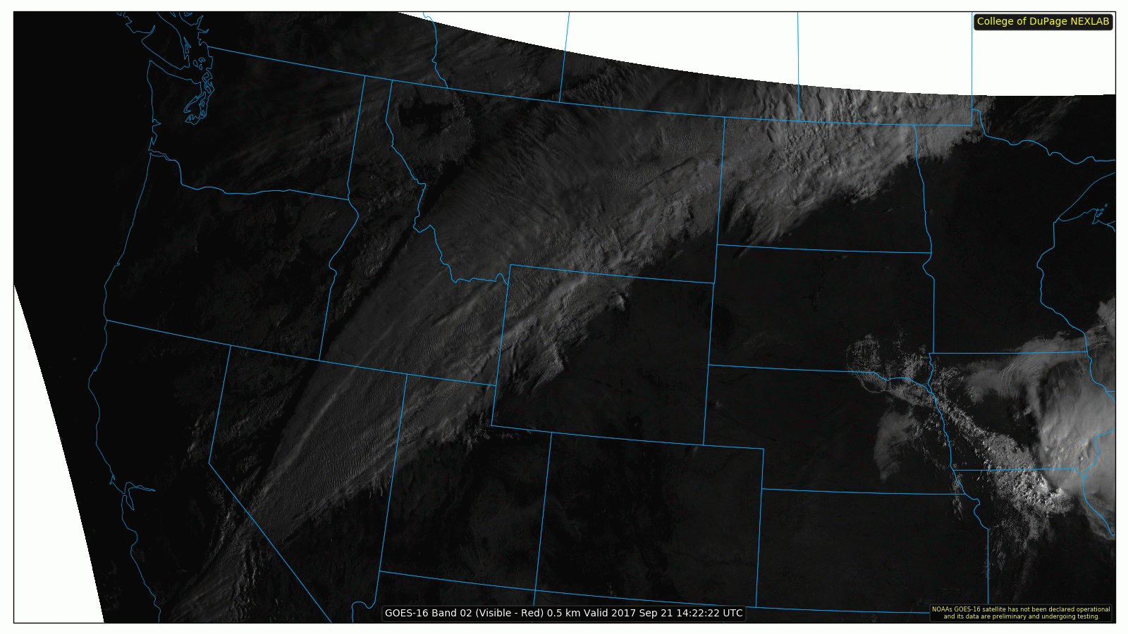
GOES-16 visible satellite loop for Thursday
Yes….the PNA index was indeed on to something. The trough will slowly push eastward and enter the state during the day Friday. Unsettled weather will then take over Saturday afternoon and linger into next week.
However…
Models are not in great agreement on what exactly happens in eastern Colorado and when over the next three to five days. While conditions will be generally favorable for extensive cloud cover and intermittent precipitation Saturday evening into Tuesday, nothing looks all that impressive just yet. The trough’s large size and overall disorganization is surely a factor. It doesn’t seem to want to consolidate its energy, but instead will likely send a series of weaker pulses across Colorado.
Clouds will probably remain socked-in beginning Saturday afternoon through Tuesday morning with general upslope in place. There will at least the chance of precipitation at all times for the Foothills and Plains these days.
What about potential for snow?
It’s only September, which in the grand scheme of things, is still early in our snow season (*throws people that picked September in our First Snow Contest under the bus*). While the airmass under the trough is very cold RIGHT NOW (snow levels in Washington state were near 5,000 feet these last few days), it’s moving rather slowly. By the time the “coldest” air reaches our region, the airmass will warm significantly. Therefore, we are expecting all precipitation across the lower elevations to fall as rain. It shouldn’t even be cold enough for our first frost or freeze either.
It will surely snow in the Mountains, and probably the higher Foothills as well. The exact snow level for the Front Range remains TBD at this time. If one of the waves passes during the overnight hours, we could see some light accumulations down to around 8,000 feet. One period we are interested in for this to potentially happen is Sunday night into Monday morning. Our GFS-derived snow level forecast map below shows levels lowering to around 6,500 feet in northwest Colorado. Closer to home in the Front Range, it will be warmer with snow levels forecast to be ~8,500 feet.
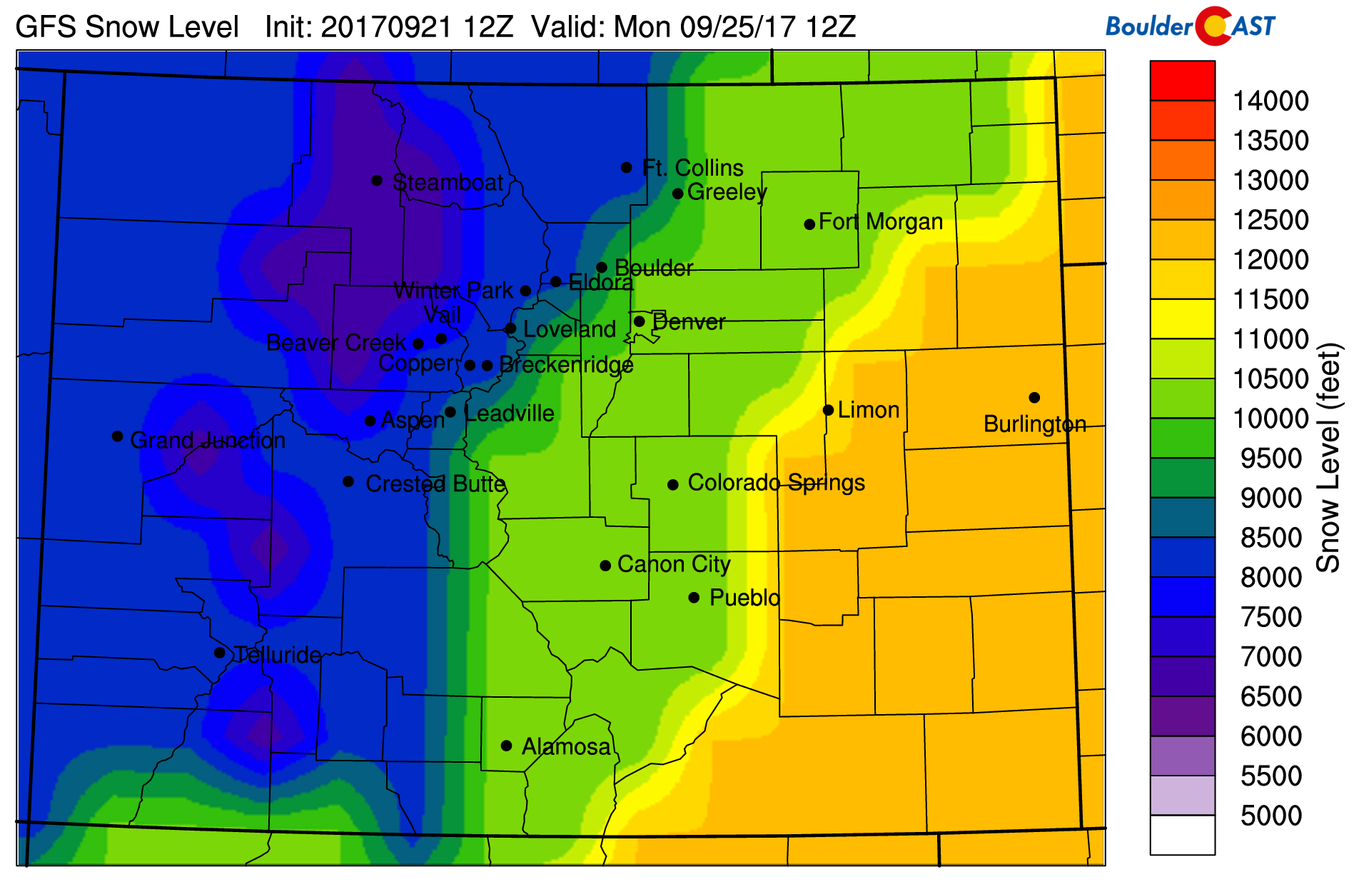
GFS-derived snow level forecast for Monday morning
The heaviest snow will fall in northern Mountains nearer to the Wyoming border. No huge totals this time. Maybe 3-8″ above tree line for the Front Range, with the potential for 12″ if things come together a little better than they look now. Higher totals are possible in Wyoming west of Cheyenne. Do expect to see the Mountains coated in white by the time the clouds clear around the middle of next week.
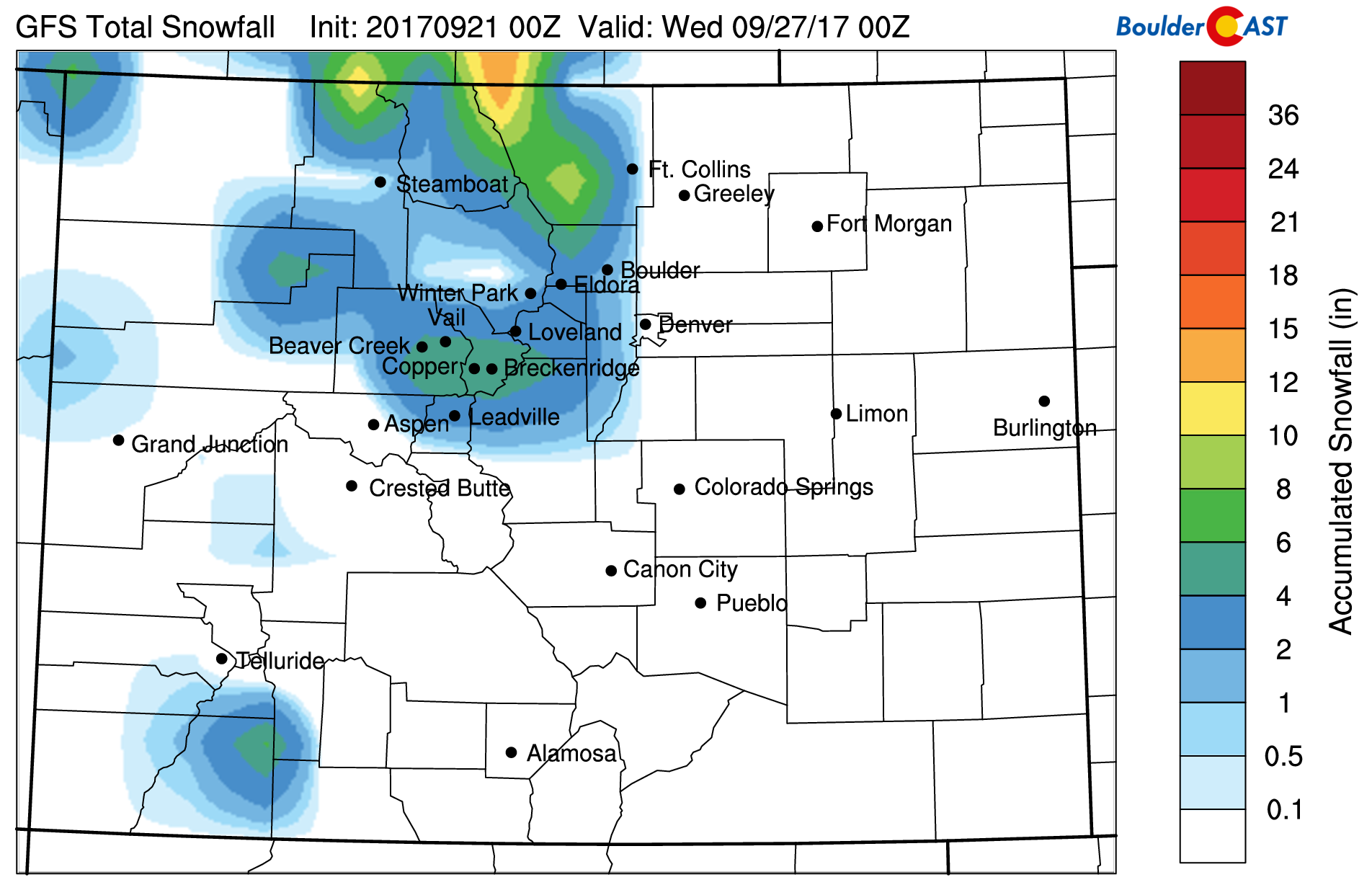
GFS model snowfall forecast through Tuesday of next week
Our team will continue to monitor things and will update if necessary. We’ll surely be revisiting this trough in some capacity in our weekly outlook post on Monday. For now, expect one more warm day Friday with temperatures near 80 degrees. Saturday will be much cooler in the 50’s, but at least the morning should be dry. Things go downhill Saturday afternoon. Be sure to plan any hot cocoa or homemade soup adventures after that…
That’s all for now!
Please share our forecast!


