The Northern Lights are truly a sight to behold. If you were caught off guard and missed the display on Monday night, you may have another chance this evening (Wednesday night). The NOAA Space Weather Prediction Center (SWPC) in Boulder is forecasting another geomagnetic storm. Read on for all you need to know.
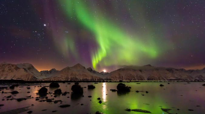
The aurora borealis, also known as the Northern Lights or just plain aurora, are the result of high-energy particles from the sun interacting with Earth’s upper atmosphere. Nitrogen and oxygen absorb these dangerous particles, and in the process, give off beautiful hues of green, violet, blue, pink and red light. The sun is constantly emitting small amounts of these particles, but because of the Earth’s magnetic field, nearly all of them are funneled towards our planet’s polar regions, making the colder, less populated locales ideal for viewing the Northern Lights. However, in semi-rare circumstances, our sun will send out powerful bursts of these particles, known as coronal mass ejections, which can make the Lights view-able further south than normal. Once such instance occurred on Monday night in Northeast Colorado, during what was likely the most intense geomagnetic storm since 2005. Some of the pictures taken in the Front Range were magnificent!
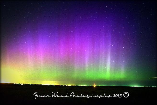
The aurora from Monday night, taken by Fawn Wood in Aurora, CO.
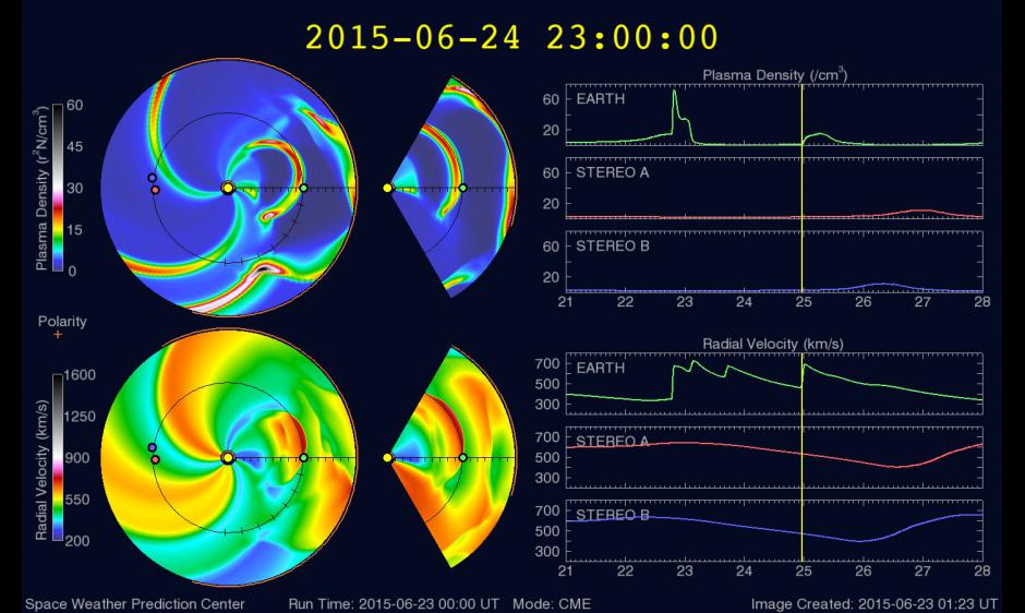
The next wave of particles is forecast by the SWPC to arrive to Earth around 5pm Mountain Time this evening, originating from a solar flare that occurred on June 22, with the potential to last for 12 hours. In the model forecast diagram below, focus on the Plasma Density graph in the upper right. Notice Monday night’s peak, and another secondary peak for this evening. The intensity of this event is forecast to be lower, but the potential still exists to see some illumination in the sky tonight. Remember, this is only a model projection, and the actual intensity could vary, either direction.
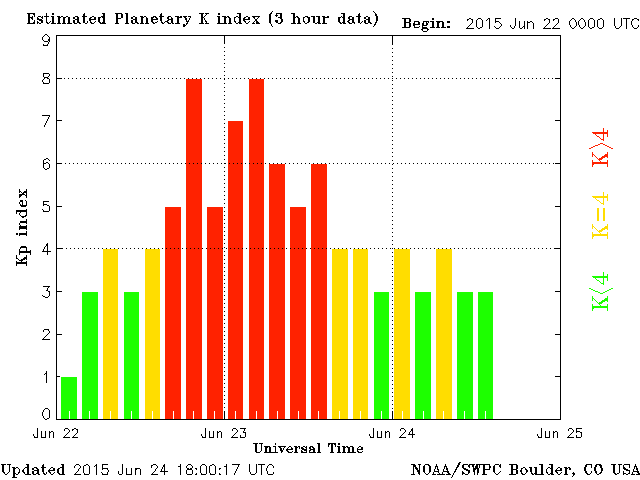
The geomagnetic activity index, or Kp for short, is projected to reach 7 this evening. This is generally considered the minimum required level to see the aurora in Northern Colorado. At a Kp value of 8, the Lights are usually easily visible over the dark parts of the Denver area (Monday night was Kp 8 at times; see below).
Based on current forecasts and our local sunset time, the best viewing potential tonight will be between 10pm and 2am. Colorado is definitely on the fringe of the viewing region, but if you have the time or desire, we urge you to keep an eye to the sky this evening! Read on for some tips.
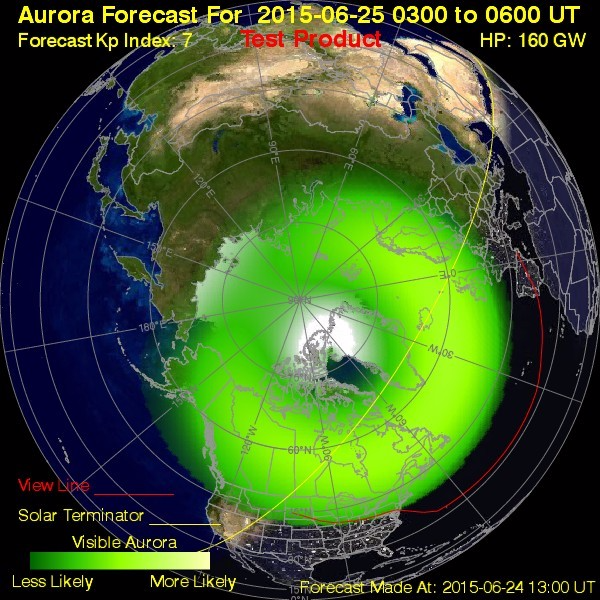
Kp index of 7 is forecast for midnight tonight.
Viewing Tips:
- Since the aurora will likely be quite faint this evening, get to as dark of a location as possible. In the Front Range, this may mean venturing 30 or more minutes into farmland. Choose somewhere that gives a clear, dark view of the northern/northeastern horizon.
- Make sure to let your eyes adjust for a bit to the darkness before throwing in the towel. Faint aurora can be difficult to detect, especially if you don’t know exactly what to look for. More often than not, auroras do not look as vibrant as shown in pictures to the naked eye. Images are usually taken with long exposures, collecting a bunch of light over time, which depicts them as brighter than they actually are. In the immediate metropolitan area, distinguishing faint aurora from light pollution will be a challenge.
- Before heading out, check the SWPC’s “real-time” aurora forecasts. These can be used as a general, first guess if there is anything to see. Of course, nothing will be more accurate than having a look for yourself.
The Weather Forecast:
Having a powerful, once-in-a-decade geomagnetic storm visible in your geographic location means nothing if there are clouds overhead. Our weather forecast moving through the evening will be crucial. Currently, there are some stubborn mid-level stratus clouds over Boulder.
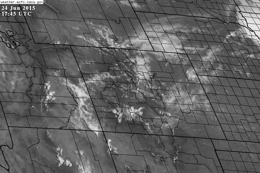
Current visible satellite image over Colorado at 1pm Wednesday.
These clouds should dissipate through the afternoon, but isolated/scattered storms will fill in the skies thereafter. The latest HRRR model run shows decent storm development along the Front Range this afternoon.
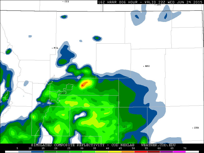
Model forecast reflectivity from the HRRR model, valid at 4pm Wednesday evening, showing storm potential. Most of the action is projected to be east of Interstate 25.
Hopefully, these storm clouds clear out shortly after sunset. At worst, skies should be party cloudy during the peak viewing hours of 10pm-2am, with more cloudiness east of Denver. The HRRR supports this hope!

Model forecast reflectivity from the HRRR model, valid at 10pm Wednesday evening, showing clearing over the Metro area.
If you can, get outside tonight…you may be in for a treat! The Northern Lights are mystifying and are something everyone should experience at least once in their life. Be sure to let us know if you manage to spot them tonight on Twitter @BoulderCAST. Happy and hopeful viewing to everyone!


