With April come and gone, we are now fully entrenched in the Spring season here in the Front Range. We take a look at current trends, past climatology, and offer our prediction for the month of May in northeast Colorado.
This content was exclusively available to BoulderCAST Premium Members through May 2, 2017.
May Climatology
Spring is an interesting time east of the Rockies. A combination of favorable storm tracks, cool Canadian air, and Gulf of Mexico moisture makes the weather in March, April, and May somewhat of a grab bag. In springtime, the winter storm track is still over the region and moisture becomes widespread enough to produce semi-frequent, significant precipitation. This combination makes this the wettest time of the year. In fact, May is Boulder’s wettest month, just beating out April, registering 3.05″ on average. The window for measurable snow for the Plains slams shut very rapidly toward the latter half of April (as we saw over the weekend), but May snow is not uncommon. In fact, May snowfall has been recorded 15 out of the last 18 years in Boulder, so don’t put those shovels away just yet! By now though, warmer air is slowly regaining its grasp on Colorado. As a result, the bulk of May precipitation generally falls as the liquid variety.
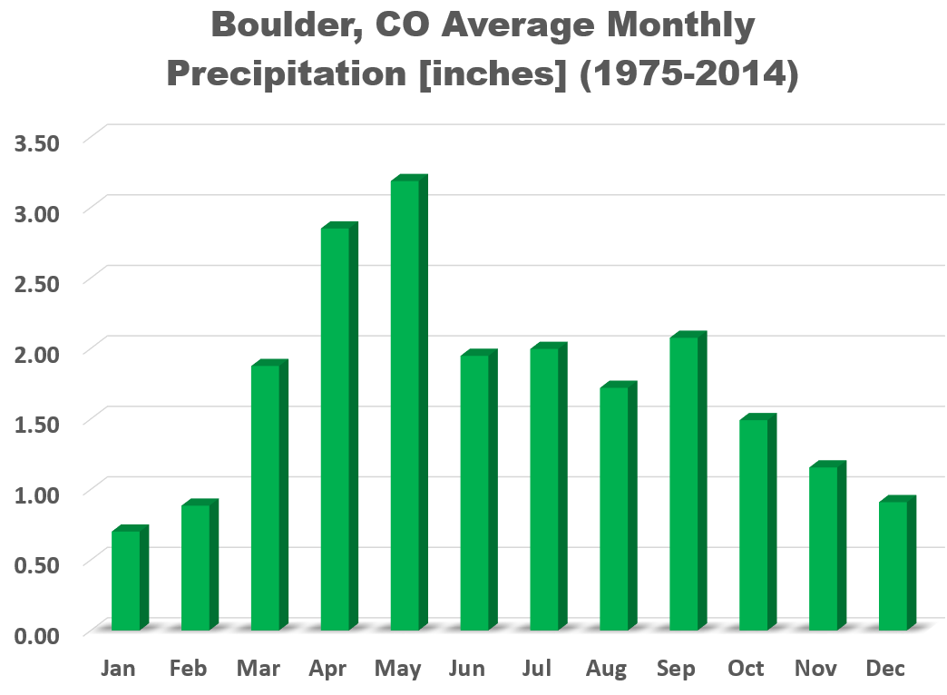
Monthly mean precipitation for Boulder. May is the wettest month of them all!
May also sees temperatures trending upward. The average high/low on May 1st is 65/39 degrees. By May 31st, it is 73/48 degrees. The hottest May day occurred on May 29, 2003 at 95 degrees, while the coldest temperature measured in May occurred on the 2nd in 2013 at 17 degrees. The takeaway: May in Denver can feel like July……or January, depending on the mood of Mother Nature at the time.
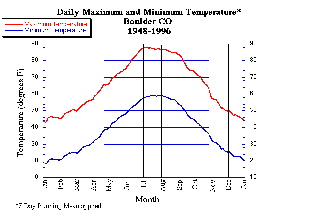
The annual cycle of mean high and low temperatures for Boulder
May also typically marks the official beginning of the growing season, as the mean and median date of the last frost occur in the first few days of May (see below).
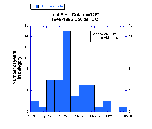
Occurrence of the last 32 degree temperature by date for Boulder. On average, the last frost is May 3rd. Unbelievably, the latest frost on record occurred on June 3rd. Fun fact: The latest measurable snowfall in Boulder occurred on June 12th, 1947.
Finally, May brings a profound jump in severe weather nationwide, including Colorado. However, Boulder County is protected from the bulk of severe weather due to it’s close proximity to the mountains. Therefore, we are mostly immune to this trend, with only 1 out of the 9 confirmed tornadoes in Boulder County since 1950 having occurred in the fifth month of the year.
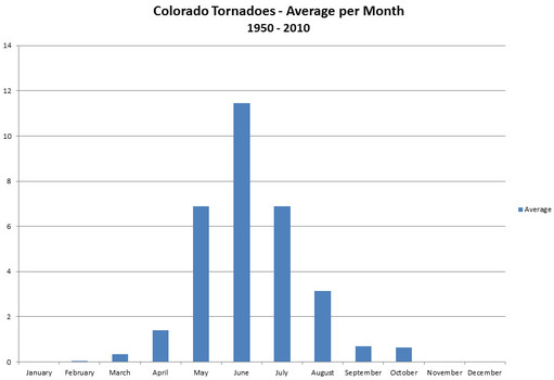
Average tornadoes observed by month in the entire state of Colorado. Data provided by NCDC.
So what should we expect this May?
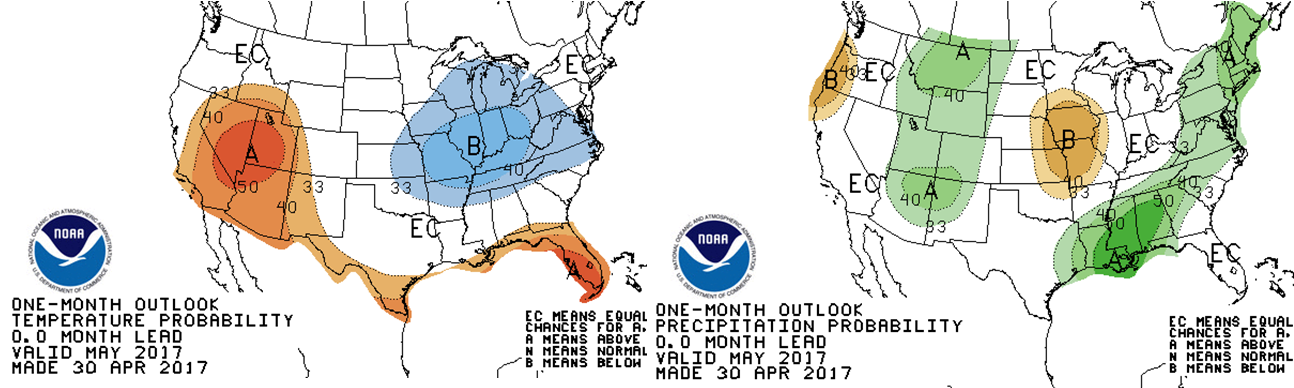
The long-range guidance of the CFS climate model suggests that the Front Range will be slightly warmer than normal for the month of May, with no signal present for precipitation.
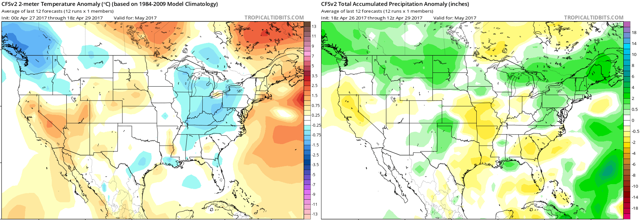
CFSv2 model outlook for the month of May. Temperature anomaly is to the left, while precipitation anomaly is to the right.
Looking at the GFS and European ensembles for the first half of May, it looks like we should expect a large ridge the first week of the month (with warm and generally dry conditions prevailing), and increased uncertainty towards week two of May. Both models show a cut-off low moving into the Desert Southwest around May 7th, with ridging remaining across the Pacific Northwest. This “split-flow” pattern could bring a multitude of outcomes to Colorado. It’s hard to say this far out.
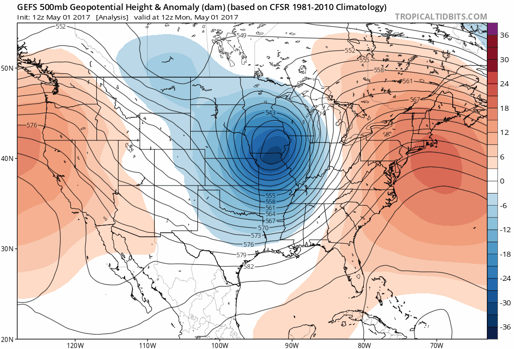
GFS ensemble forecast of 500 mb geopotential height for the first 15 days of May
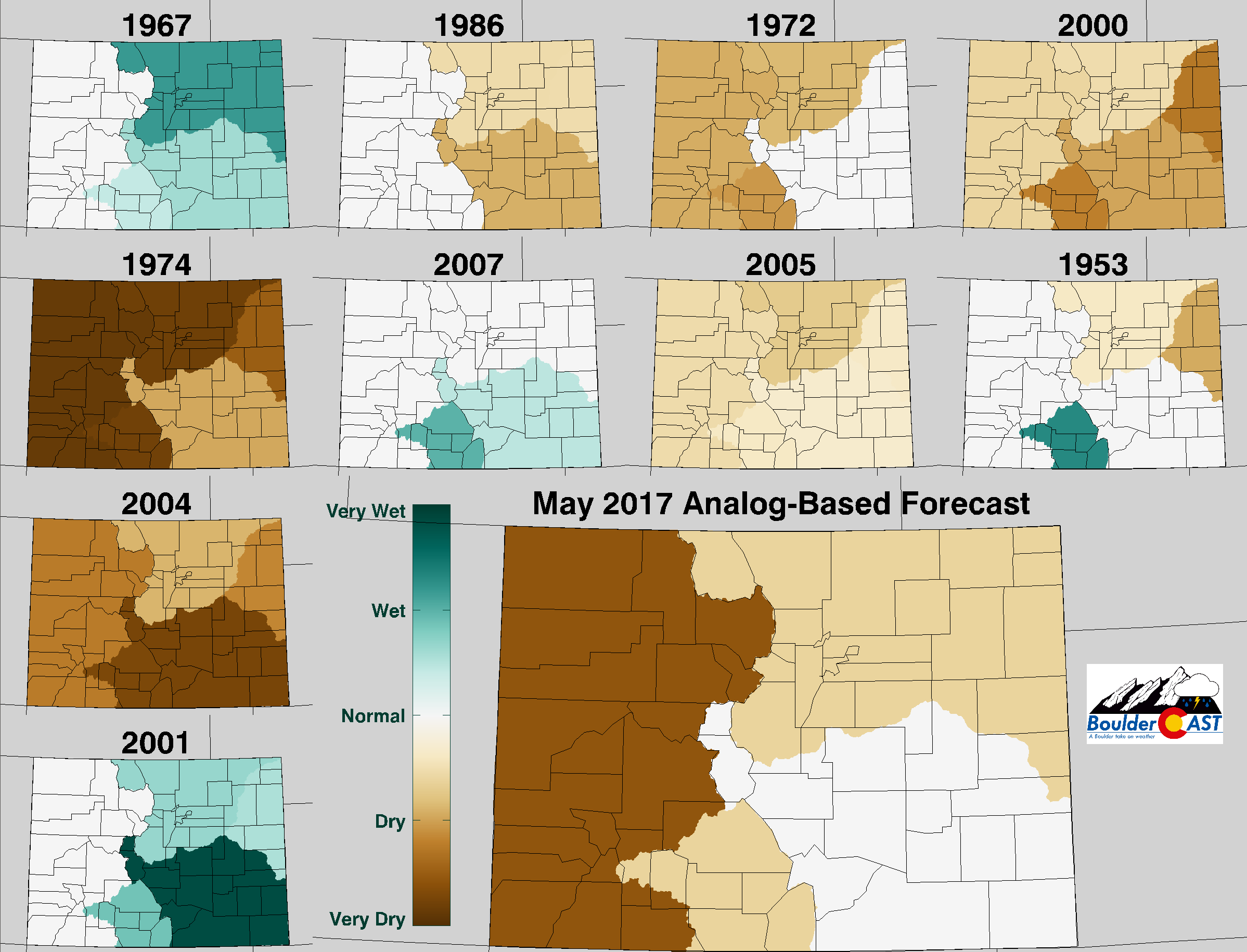
Another method we use to forecast for the month ahead is to extrapolate past weather patterns towards predicting future weather with analogs. Using this technique, we compare recent weather data (from the last few months) to the historical record dating back to 1950.
Based on this analysis, May 2017 has equal chances of all temperature outcomes across the Front Range:
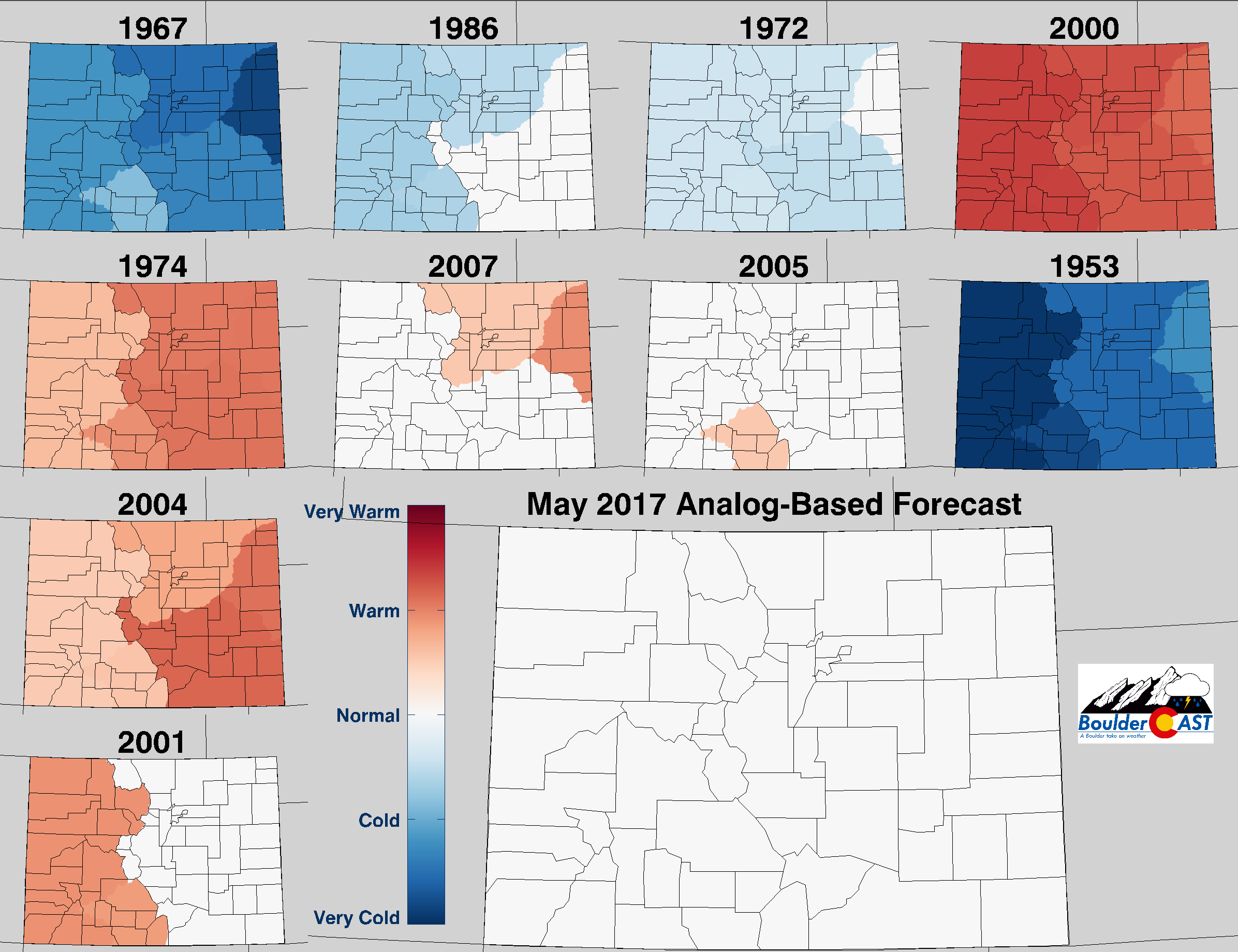
However, we see elevated odds of below normal precipitation (7 out of 10 analog years were drier than normal for north central Colorado)…
NOAA’s Climate Prediction Center is expecting equal chances of both above and below normal temperature for the Front Range (i.e. they aren’t leaning towards anything at all). They also include our region in slightly elevated odds of above normal precipitation for May 2017.
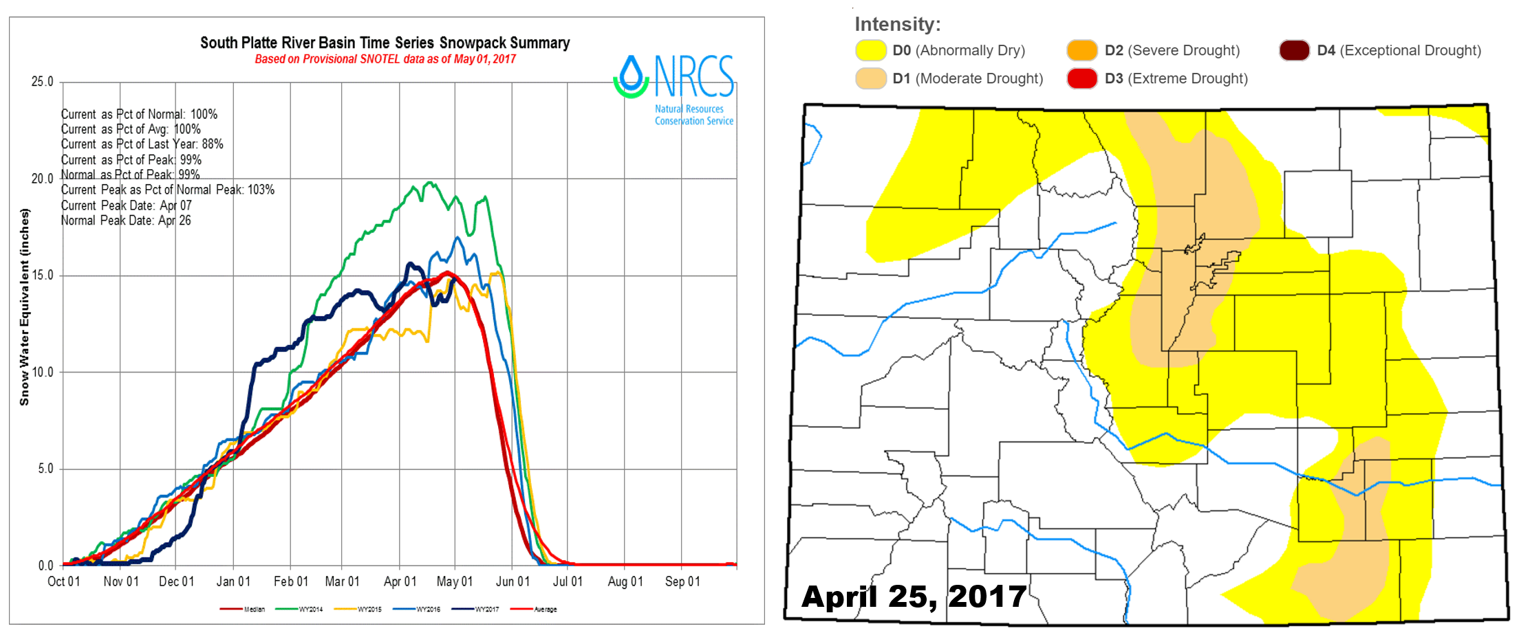
Blending everything we are seeing, we are forecasting near normal precipitation AND temperatures for the month of May. Keep in mind…both precipitation and temperature have not finished “near” normal together in the same month since December. Here’s to hoping we can manage AT LEAST normal precipitation for the month… With our snow pack currently resting at 100% of normal and drought coverage widespread across the Front Range, added precipitation will help to ensure we avoid another wildfire season like 2012! FYI, there is also growing speculation that El Niño will return this fall. That is a topic for another post, however. For now, enjoy our the rest of our rainiest month!
Don’t be selfish…share our forecast with your friends!


