Less than ten hours after the mercury hit 70 degrees in Boulder, heavy wet snow was already piling up in the midst of another classic Front Range snowstorm, one that turned out to be Denver’s biggest in nearly a decade. There’s no camouflaging the utter forecasting disaster that transpired. We’ll definitely own up to it, do our best to summarize this historic blizzard, and outline the factors that contributed to the storm’s last-minute explosion!
March is an interesting, fickle time in Colorado. Spring is in the air, with warmth and moisture beginning to make their way back northward. However, winter’s grasp is only a cold front away. We always need to be cautious for the next “big one” on the horizon, for March is our snowiest month. The lack of much activity in recent years has shielded us from the true, capricious nature of March weather in the Front Range. This week’s historic blizzard serves as a fresh reminder.
The Forecast
The consensus of forecasts leading up to the storm was that it would be quick-moving, relatively strong, and create a downslope wind field that would be detrimental to significant snow from Boulder into the western parts of Denver. The area of concern for “big” snow was just to the east of Denver, where totals in the 6-12+” range were expected. Boulder was going to have a tough time scraping out even 4″, considering the downslope and speedy nature of the storm. Historically, you will be hard-pressed to find a snowstorm in Boulder exceeding 6″ when downslope was present throughout the event. Here is what the NAM model was projecting for snowfall as of Tuesday morning; a clear downslope signature, with Boulder smack in the middle of the snow-less bulls-eye. The GFS and Euro models painted more-or-less the exact same picture.
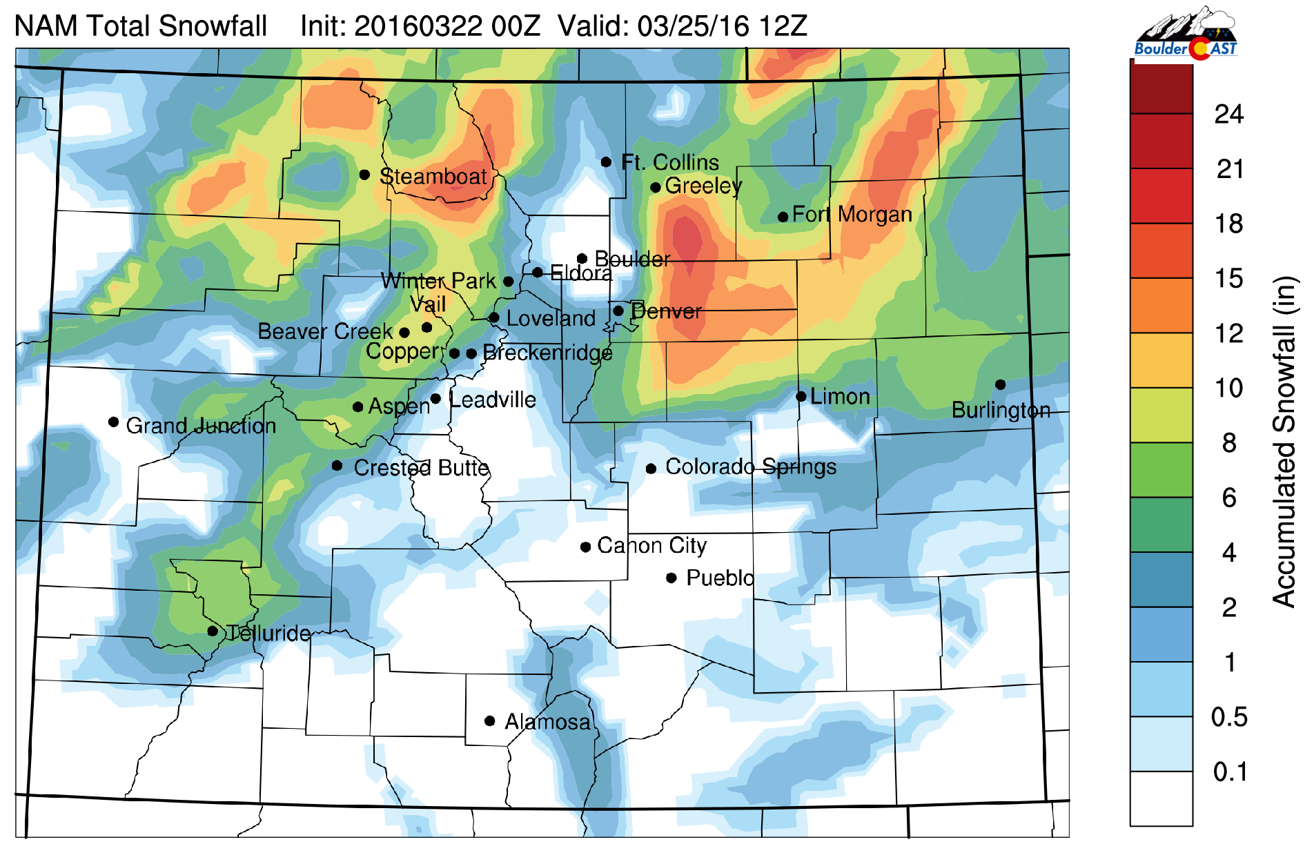
Forecast snow amounts from the NAM model that was run Monday night. A clear downslope signature is present in Boulder (no snow!)
While we knew that area would get some snow, there was absolutely no indication that, in fact, that very region would be ground-zero of a full-fledged blizzard.
The Model Bust Heard Round the World Denver Metro
As Tuesday afternoon progressed, the short-range models began to make their predictions for the beginning part of the event. They were showing a marked reduction in the amount of downslope, and therefore, a westward shift in the heavy snow. As the onset approached, it became clear that the storm was slowing down, tracking slightly further south, and exploding into something more substantial that the GFS, NAM, or European models were consistently projecting in the days leading up to the storm. The NWS upped their forecast from 3-6″ for Boulder to 4-10″ Tuesday evening. We bumped our amounts even higher, to 5-12″ for every location in the Denver Metro area. We knew there would be heavy banding and some locations would certainly exceed 12″, but no one could have forecasted 12-24″ being as widespread as it was. Not a single model was swinging that big…
The biggest contributor to the change is that the slight shift in track eliminated the strong downslope component to the wind. Not only that, powerful northeasterly upslope was its replacement. Essentially we removed something very detrimental for snow and added explosive fuel to the fire. Here is the short-range RAP’s forecast from 9PM Tuesday night, valid at 9AM Wednesday (during the height of the storm). Strong, 30 to 50 mph northeasterly upslope at 700mb!

700mb temperature and wind forecast from the RAP model, valid at 9AM Wednesday (during the height of the storm)
With the more southern track, the downslope was pushed further south into southeastern Colorado. Ask Colorado Springs how much snow they go from this event? Hint: It was less than 4″. As the storm was happening, the NAM model finally picked up on the upslope. The wind profiles from the Wednesday morning run are shown below. The upslope is deep (extending through the entire depth of the troposphere!) and strong from the NE/NNE (40 – 60 mph at 700mb!).

NAM forecast wind profiles for Boulder, with the deep upslope during the storm circled in red
While not a perfect direction for upslope, the sheer speed more than made up the difference. We can almost call this fast fetch of wind present at 700 mb at 18Z a barrier jet, but the lack of true easterly flow makes it marginal. If it was, it would have only helped to enhance precip rates in western Denver.
When considering the moisture content of the air that was advecting into the Front Range from the northeast Wednesday morning, the stage was set for intense snowfall. The precipitable water during the event was 0.3-0.4″, quite high for this time of year. The map below shows the moisture pool available to the northeast and the mean wind in the lower atmosphere. Surface temperatures hovering near freezing throughout the day maximized the low-level moisture for snow.
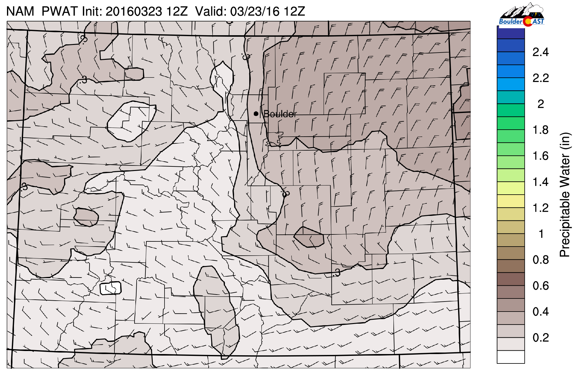
NAM precipitable water forecast for 6AM Wednesday (near the onset of the storm). Unseasonably high moisture was present across NE Colorado
We should also note that storm speed was just a smidge slower than original expectations, leading to a couple extra hours of snow for everyone. While this may not seem significant, the atmosphere was primed and ready to ring out the springtime moisture as heavy snow across the area. With snowfall rates exceeding 2″ per hour in many locations, additional storm time produced big jumps in final snow amounts.
Finally, there is the presence of conditional symmetric instability. We won’t rack your brain with a full explanation. Just know that it’s a special type on instability/frontogenesis present to the northwest of a surface low driven by mid-level dry air. This likely contributed to the bulls-eye of heaviest snow just southeast of Boulder.
In our opinion, the biggest factor was the wind shift. Once that happened, all the other necessary ingredients were in place for a thick blanketing of springtime snow. Even with the NWS continuously bumping up their snow amounts as the storm wore on, they could never keep up. At the end, they had 8-14″ for Boulder and 7-15″ in Denver, both of which were far too low. This speaks volumes to the extreme unpredictability of the storm. It couldn’t even be now-casted!
For more insight into the mind of weather forecasters when faced with a similar situation, check out our recap post from a very comparable series of events which occurred in the hours leading up to the December 15, 2015 snowstorm in Boulder (an 11-incher). A 30-degree shift in wind direction or a 50-mile change in storm track can bust a forecast either way. It’s the nature of the business when forecasting Front Range snowstorms.
Epic snow
Snow totals from across the region were astounding, with just about everywhere exceeding a foot of snow. Numerous locations approached and even surpassed two feet. A preliminary snow analysis map created by the NWS shows the heaviest snow was in southeastern Boulder and northern Jefferson counties.
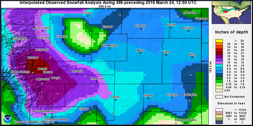
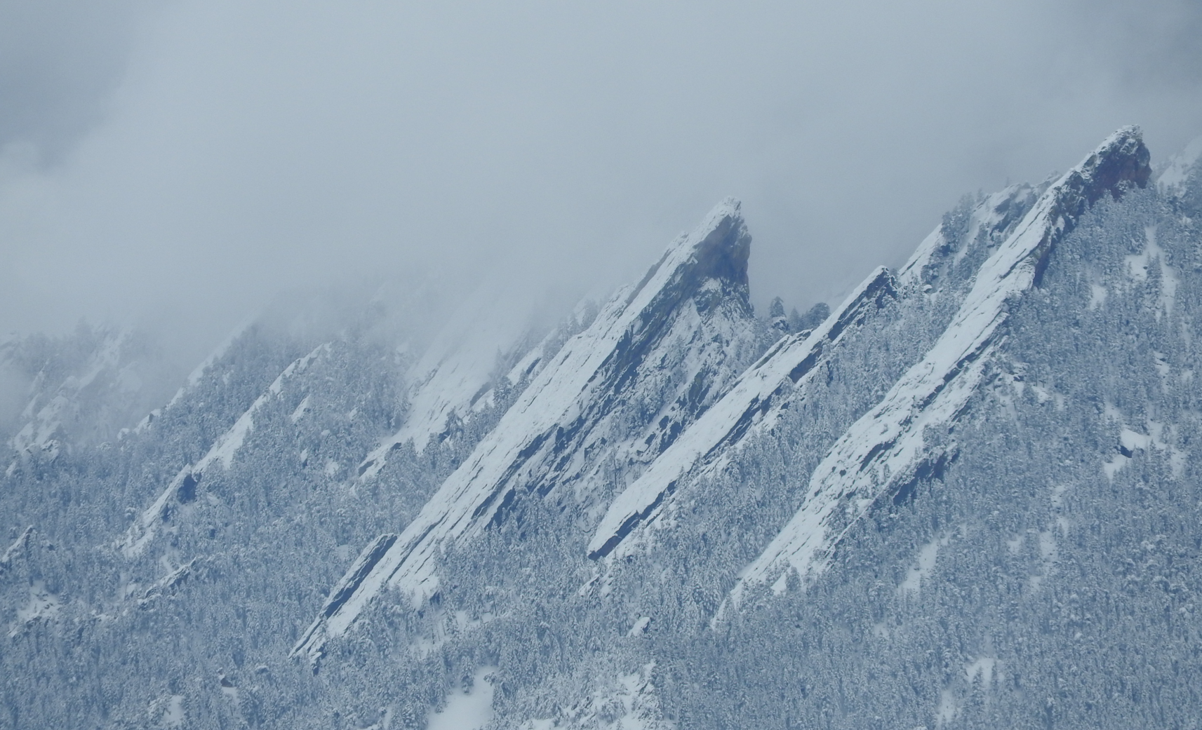
Boulder officially recorded 16.4″, setting a new daily snowfall record for March 23rd. We measured a little less at our location in North Boulder (15.2″). Denver’s official snow total was 13.1″, eclipsing the daily and the March 24-hour snowfall records. Arguably, this was the most substantial snowstorm for the region since 2006. Blizzard criteria were definitely met from Denver east, with 50+ mph winds gusts persisting for six hours or more, making for dangerous travel, causing widespread road closures and power outages, and even a total halt on air traffic at DIA. To the west in Boulder, the wind was gusty at times, but never quite reached the threshold for blizzard status.
Needless to say, this storm will remain close-at-mind for many across the area for quite a while to come. That snow, though, on the other hand, will be gone before you know it.
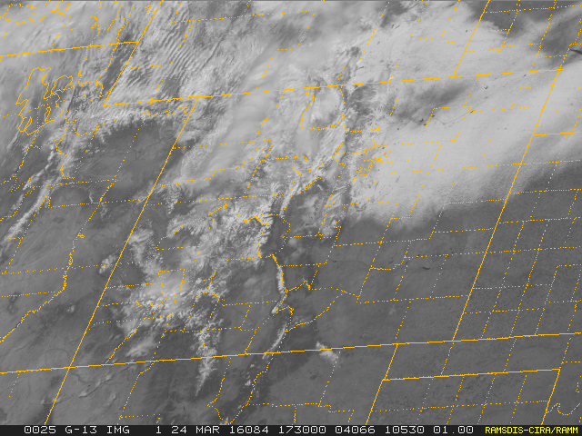
Visible satellite image this morning showing the swath of fresh snowfall across northeast Colorado.


