Goodbye Spring! Our weather has already turned colder following the passage of a front earlier this morning. The stakes get raised even further Thursday night into the day Friday when a wide range of precipitation is expected across the Front Range. In this end of week forecast update, we talk freezing drizzle, rain and snow. And yes, there is a snowfall map!
The short version:
- A storm currently located in southern California will advance across Colorado on Friday
- Drizzle and freezing drizzle will be possible Friday morning in some areas
- Scattered rain/snow showers are expected late morning into early evening
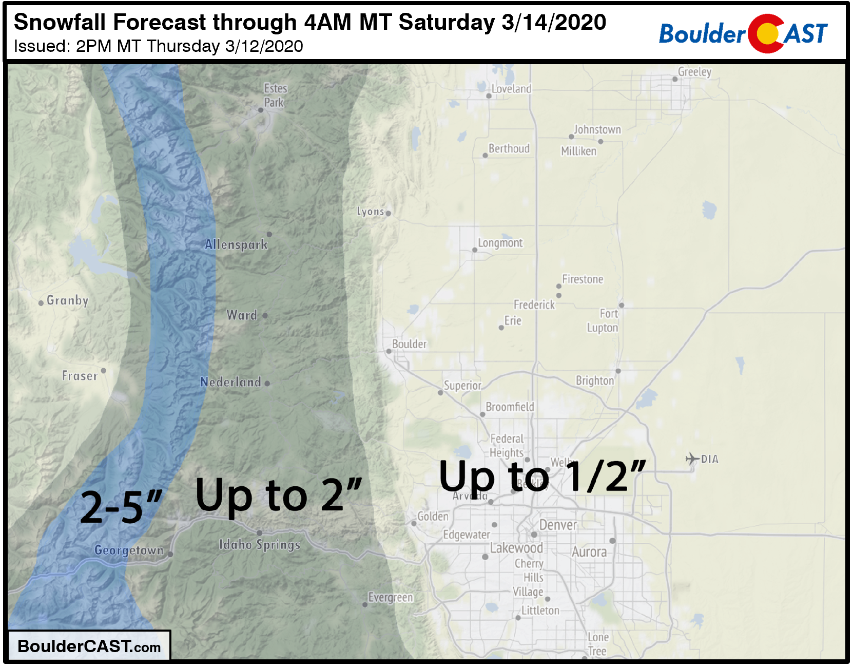
- Warm temperatures and the mid-March sun will limit impacts, less than 1/2″ of accumulation
Freezing drizzle, drizzle, rain, and snow
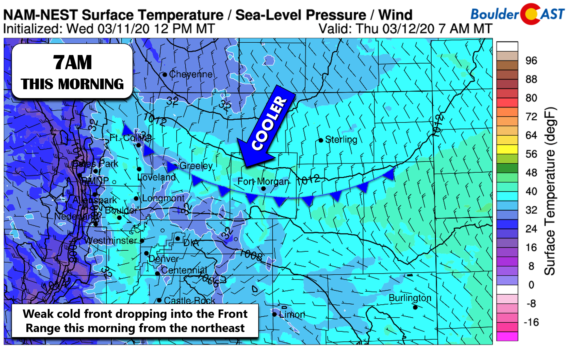
Acold front pushed through the Denver Metro area earlier this morning from the northeast. This weak trailing front is associated with a weather system all the way north trekking along the Canadian Border. Moisture is limited and there is absolutely no upper-level support with this front. Thus, the only real change today comes in the form of much chillier temperatures. It’ll be about 20 degrees colder compared to Wednesday’s highs which were in the upper 60’s. Skies will be mostly cloudy on Thursday with a light breeze from the east or northeast.
However, our main forecasting challenge over the next 36 hours is off in the other direction. A cut-off low pressure system which has been lingering near California since Sunday is finally going to kick eastward during the day on Friday (see below).

NAM 500mb height and vorticity forecast for Thursday into Friday evening. A cut-off low near San Diego opens up and heads across Colorado on Friday.
As this storm approaches and passes across Colorado, it will transition quickly from a closed-low to an open wave and weaken considerably. This can be observed in the animation above. Despite this, this storm will offer a convenient mash-up of winter-like temperatures at the surface being over-run by subtropical moisture aloft.
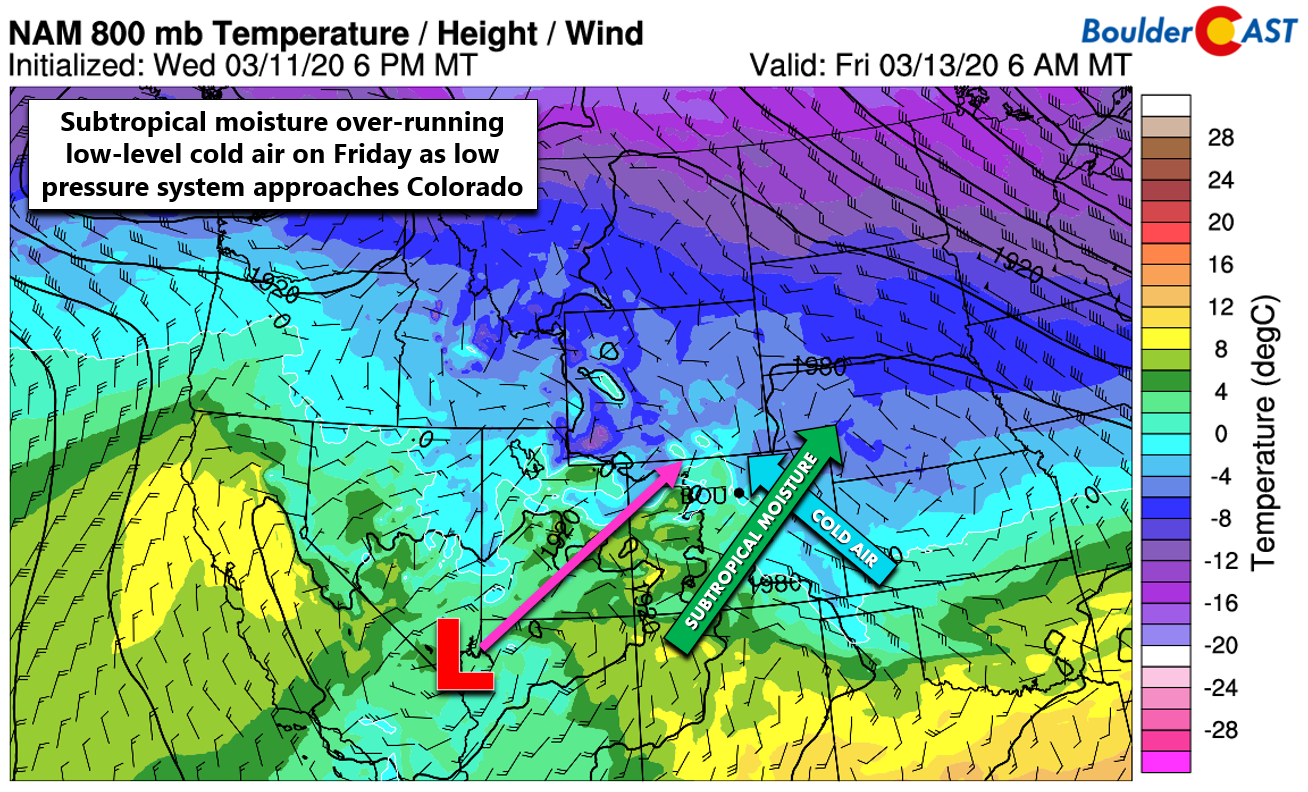
Before the upper-level moisture and lift arrives around mid-day Friday, there will be a period during the morning where shallow and moist southeasterly flow inundates the Front Range. This is shown in the graphic below. With temperatures likely hovering near or just below freezing during this time, freezing drizzle is a possibility for portions of the Metro area. Under this flow pattern, the northern Front Range is most at risk for seeing drizzle with the potential to freeze on contact: watch out Longmont, Loveland, into Fort Collins.

The immediate Denver area still has the risk, but it is lower due to downsloping from the Palmer Divide and also a potential Denver Cyclone scenario developing with northerly or northwesterly winds setting up in Boulder and Denver. If you do see some drizzle in your area, there’s also the possibility that temperatures remain just warm enough to keep it from freezing. Nonetheless, do be a little careful during the morning commute Friday.
Late Friday morning, the threat of drizzle and freezing drizzle will lessen and be replaced with scattered snow showers across the Metro area. Temperatures will warm into the middle to upper 30’s, so it will be a very wet snow which could mix with rain at times. The mid-March sun and warm temperatures will inhibit much accumulation from this event. Had things aligned during the overnight hours, we might have seen more snow sticking. But alas, this is going to be wintry event with little to no impacts for us as snow levels hover between 5000 and 5500 feet elevation with whatever falls not really sticking much if at all.
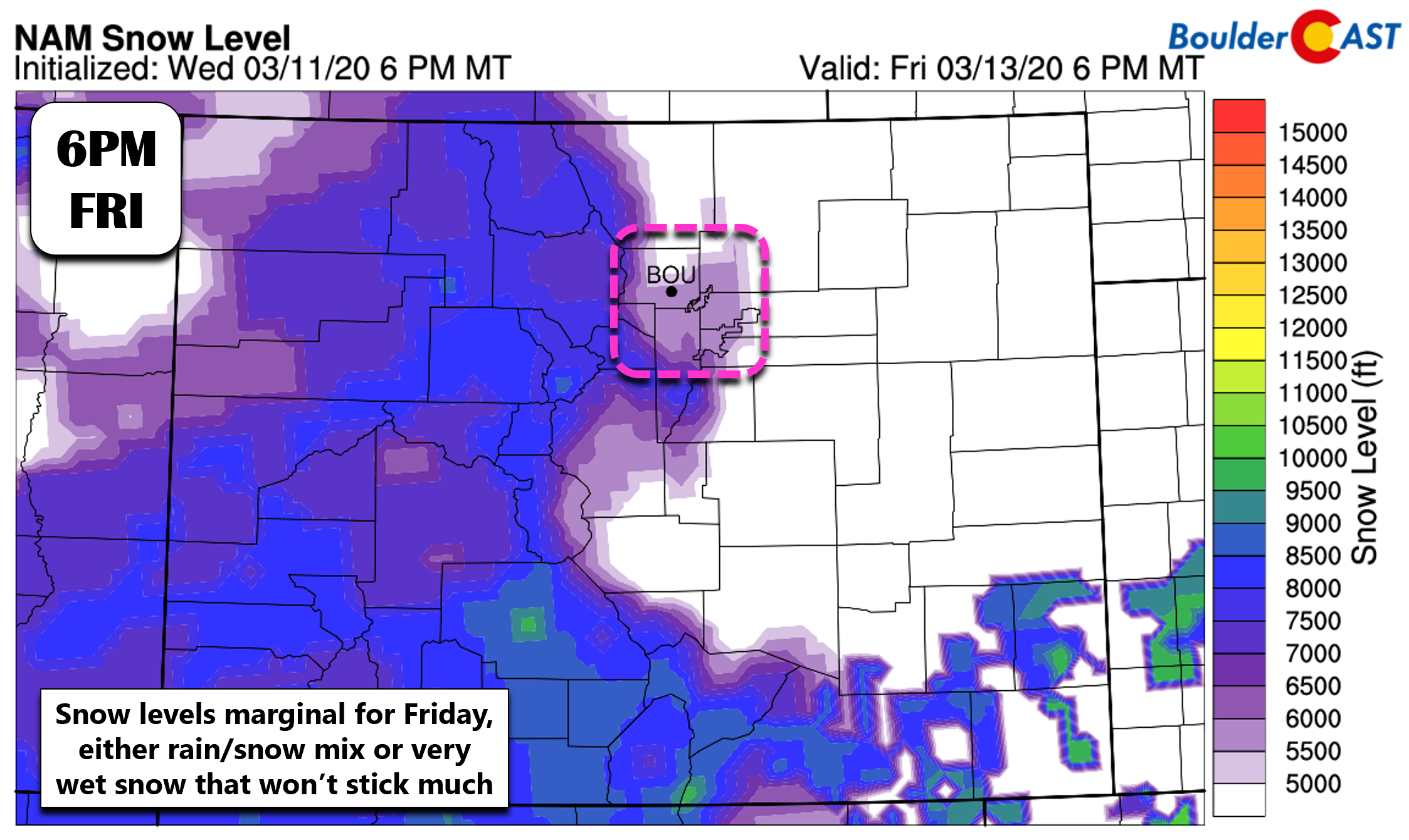
Current model-derived snowfall forecasts agree well with our thoughts (for once!), showing essentially no snow accumulation across the lower elevations of the Metro area. An inch or two of accumulation is possible in the higher elevations, the far eastern Plains of Colorado, and north of Fort Collins along the Wyoming Border.
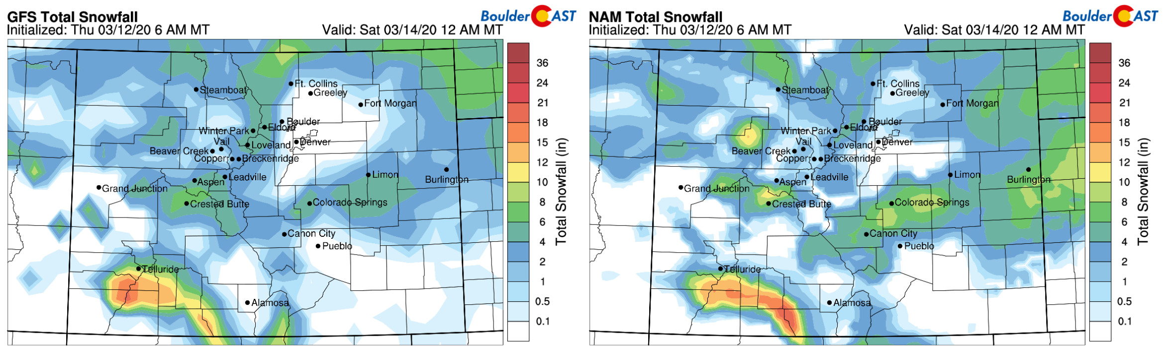
Our sad snowfall forecast map for the event is shown below.
Prime time for any scattered rain/snow showers will be from 9AM to 6PM during the day Friday. These could be fairly spotty given the general downsloping southwest flow of the system as a whole. Do watch for areas of freezing drizzle in the morning, though. Enjoy the cold and gloomy end to the work week!
Help support our team of Front Range forecasters by joining BoulderCAST Premium. We talk Boulder and Denver weather every single day. Sign up now to get access to our daily forecast discussions each morning, complete six-day skiing and hiking forecasts powered by machine learning, first-class access to all our Colorado-centric high-resolution weather graphics, bonus storm updates and much more! Or not, we just appreciate your readership!

.
Spread the word, share our forecast!


You must be logged in to post a comment.