
While the fire ban has been recently lifted in many Front Range counties, September did little to relieve the parched landscape with yet another month of well below normal precipitation. Will October offer up the soaking rain and mountain snow that we desperately need? Read on as we examine Boulder’s climatology and consider the current state of the atmosphere to give our outlook for the next month.
Recapping September
Boulder had an average temperature that was 2.1 degrees above normal (including four 90+ degree days), and only 0.45″ of rain for the month of September (Denver was 2.6 degrees above normal with only 0.28″ of rain). With help from the last week of plentiful sunshine, Boulder is currently riding a streak of 14 consecutive days without measurable rainfall. The monsoon also didn’t put up much of a fight in September, or all summer in fact, with beneficial subtropical moisture being stubbornly hard to come by. The maps below outline September’s temperature (left) and precipitation (right) anomalies.
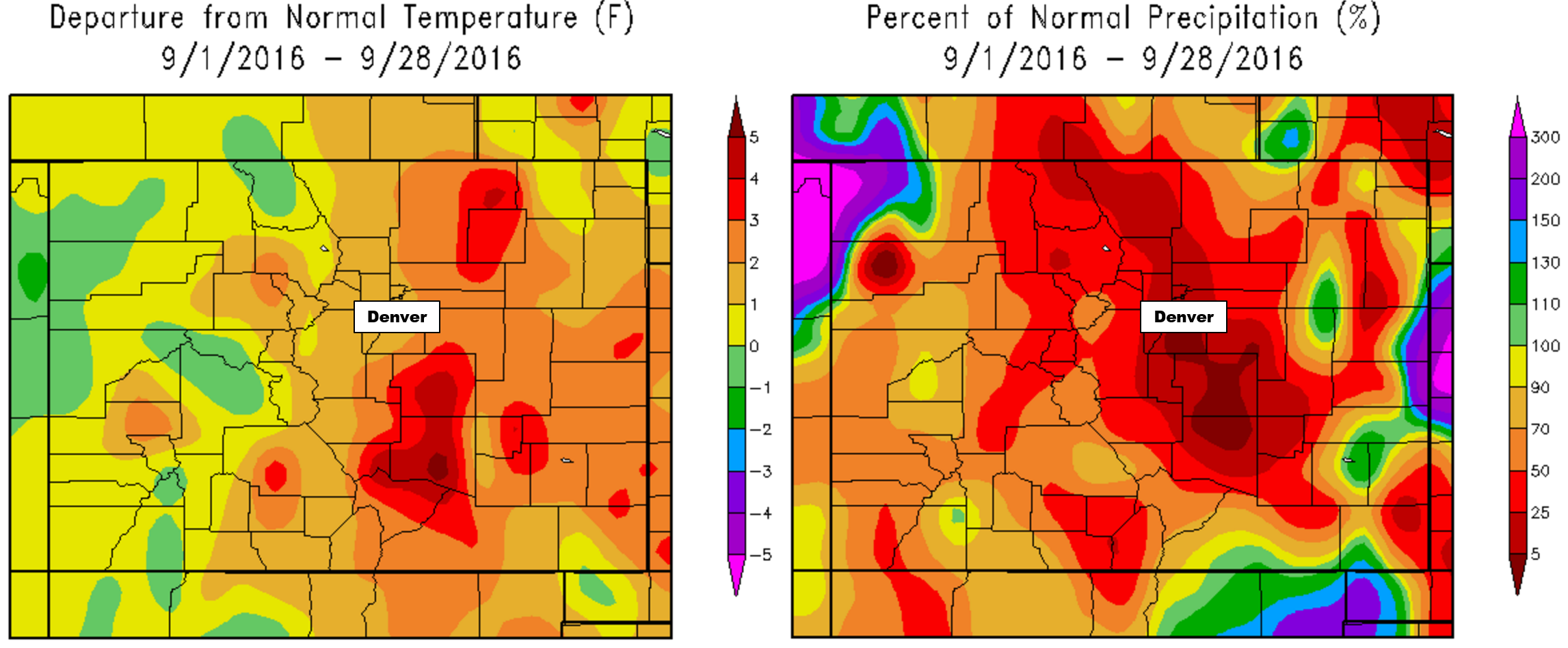
Precipitation and temperature departures from normal for Colorado for the month of September 2016.
As a result, our drought has only worsened in the last thirty days. Here is the most recent analysis from the National Drought Mitigation Center (as of September 27, 2016):
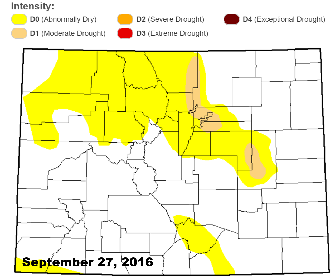
30% of our state is now considered “Abnormally Dry,” up from a value of just 5% at the end of June! A new region of drought has developed southeast of Denver as well, in addition to the pre-existing area in eastern Boulder/Larimer and Broomfield counties. It’s not a dire situation just yet, but things are quite dry out there. In our opinion, it was surprising that many counties decided to drop the fire ban. It really wasn’t that dry this summer to warrant the ban in the first place. But now, it’s even drier than it has been, leading to a bit of a head-scratcher.
If you recall, our September 2016 outlook called for near normal temperatures and below normal precipitation for the Denver Metro area.
Shifting focus to the next month…normally, October across the Front Range is quite beautiful, with mild, sunny days and nights starting to feel quite chilly. It doesn’t rain all that much, but snow can be a game-changer (particularly during El Niño years). Let’s take a closer look!
October Precipitation History:
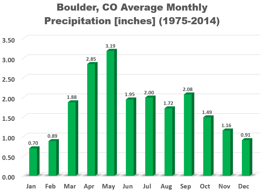
On average, Boulder receives 1.49″ of precipitation in October, marking the beginning of the “dry season” for much of the Mountain West, including Colorado.
The graph below shows October precipitation totals since record-keeping began in Boulder.
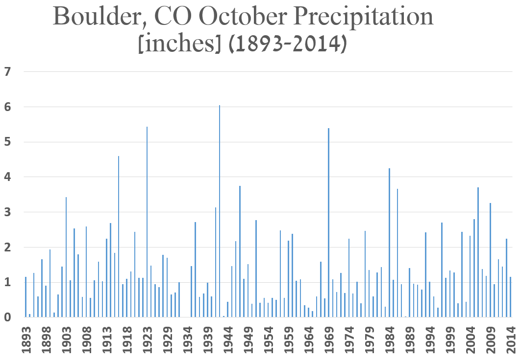
Most Octobers have less than 1.5″ of precipitation, however, in 1942, 6.04″ was recorded, thanks in part to 23.0″ of snowfall. Speaking of the white stuff, October is typically when we see our first snowfall of the winter season, averaging about 5″ in Boulder for the month. However, snow-less Octobers have occurred 33 times since 1897 (including October 2014 and 2015), about once every four years. However, in the Foothills, snow is almost a guarantee this month!
Click here to see when you all, the readers, think our first snow will occur this year…
October Temperature History:
October continues the drastic, downward trend in temperature that started in September. The average high temperature plummets from 72 degrees on the first of the month, to just 58 degrees by Halloween. The hottest temperature for the month was 90 degrees, observed on October 1, 1953. On the 26th of October in 1917, the temperature dropped to a icy -2 degrees. Quite the range of possibilities!
October also sees the growing season end with our first freeze and frost of the year. The median date in Boulder for the first frost is October 1st, while the median first freeze date is October 11th.
This Year’s October Outlook:
Below we review several factors individually that we take into consideration for our outlook of October.
EL NIÑA / LA NIÑA:
The equatorial Pacific Ocean remains on the brink of shifting into a La Niña phase for the first time in four years. The graphs below show sea-surface temperature anomalies for various regions spread across the Pacific. Though the historic El Niño of last winter has been vanquished and is transitioning into a weak cold anomaly, little change has occurred in the last three months.
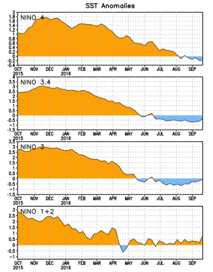
Current temperature anomaly plots for four regions of the equatorial Pacific Ocean
Arguably the most important region, NIÑO 3.4, has been hovering around -0.5 degrees since mid-June, though it has trended upwards in September. This value is on the cusp between ENSO neutral and a weak La Niña. Looking forward, climate model forecasts now almost exclusively keep conditions neutral through the winter.

Model ensemble forecasts for Nino 3.4 region temperature anomaly.
We haven’t posted our ENSO analysis for Fall 2016 yet, but we can offer a “sneak peak”. Assuming ENSO neutral conditions remain in place for the month of October (very likely), we found the odds of a wetter than normal October are slightly increased, but ENSO neutral doesn’t say much about our temperatures for the month. Truth be told though, obtaining useful insight from ENSO during its neutral phase is an uphill battle in Colorado during the fall months. Therefore, we’ll weigh this lightly.
WEATHER MODELS:
Contrary to the recent ridge, the mid-range ensemble model consensus shows an active weather pattern over the northern Rockies for the first week of October. This will lend to cooler weather and increased potential for precipitation. However, there is good agreement in a ridge re-building during the second week of the month and beyond, but uncertainty is large that far out.

GFS ensemble forecast for 500 mb height through mid-October
CLIMATE MODELS:
We often consult the Climate Forecast System long-range model to help guide any potential forecast for the upcoming month or season. It infrequently verifies well, but neither do many forecasts speculating what the month ahead will bring. With that said, as you can see below, the CFS model is thinking warm and dry(ish) for October across northeast Colorado.
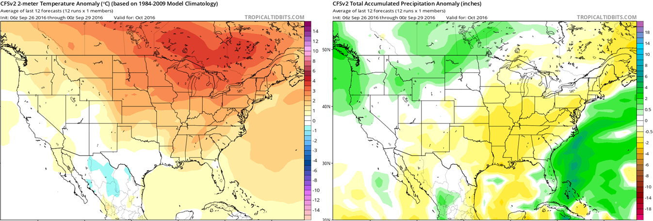
Climate Forecast System outlook for October’s temperature (left) and precipitation (right) anomalies.
There is a striking lack of cool anomalies (blue) in the left map. The CFS really believes almost all of North America will see a warm October. Seems possible at least considering the ridgy nature of the weather models beyond the first 10 days of the month. In the right map for precipitation, notice that Colorado lies in between the soggy Pacific Northwest and the dry Southeast United States. This lends little confidence to precipitation input for our region from the CFS model (i.e. it could go either way).
Fun fact: the large green area off the eastern coast of Florida is the model picking up on the high likelihood that Hurricane Matthew will move through that region in the first few days of the month.
BOULDERCAST ANALOGS:
Based on what 2016 has dished out recently, our algorithms choose the top ten historical analogs (years that thus far have been most similar to 2016 in regards to temperature and precipitation for the Front Range). They point towards this October being drier than normal for all of Colorado, but provide no information about temperature.
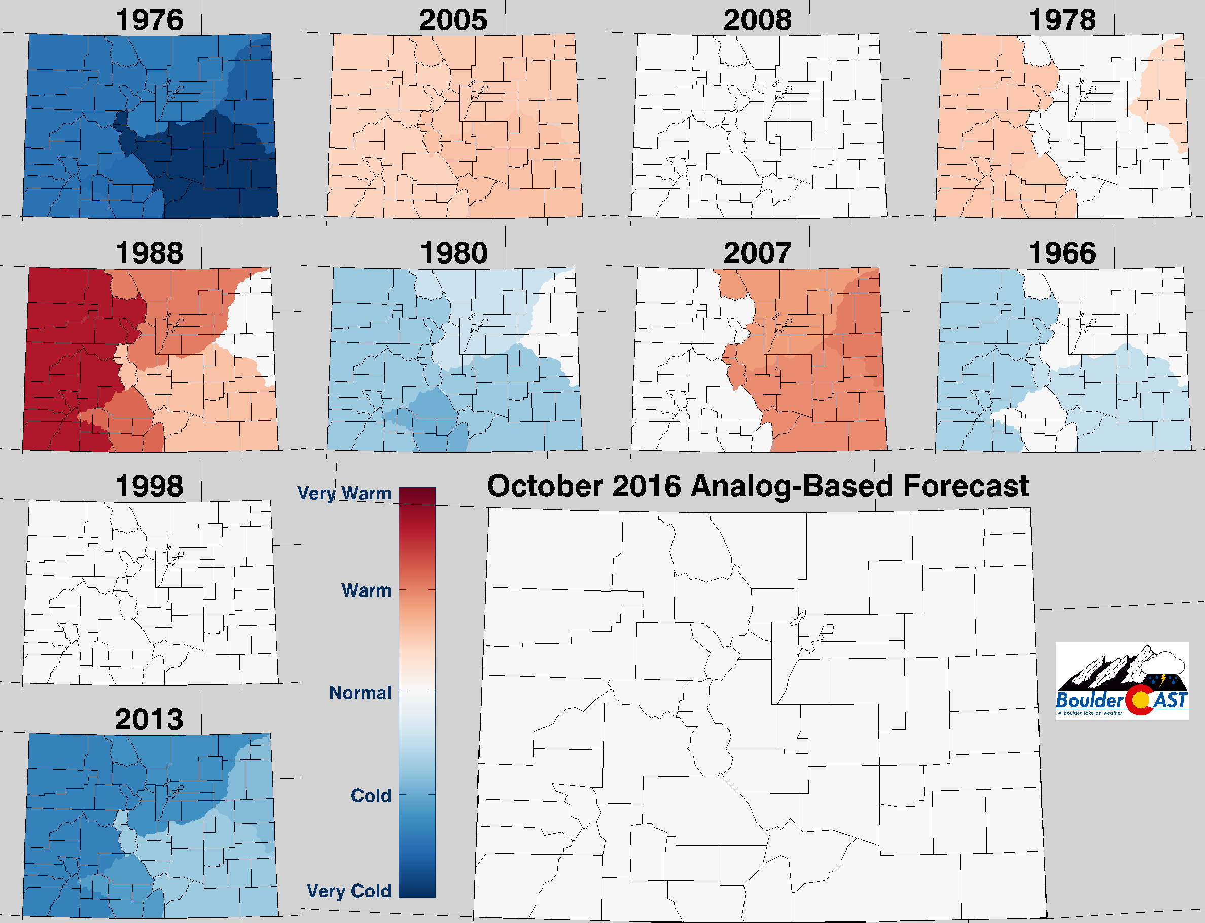
Top 10 Analogs to 2016 and how those years played for TEMPERATURE in Colorado during the month of October. The large map shows the analog-based weighted consensus forecast based on those 10 years.
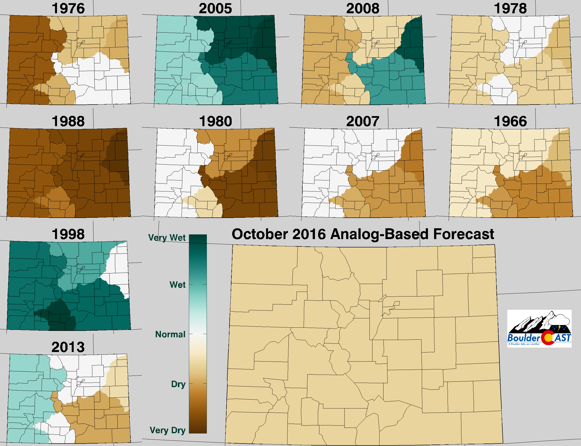
Top 10 Analogs to 2016 and how those years played for PRECIPITATION in Colorado during the month of October. The large map shows the analog-based weighted consensus forecast based on those 10 years.
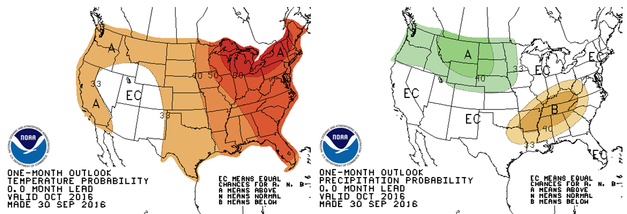
NOAA’S CLIMATE PREDICTION CENTER:
The Climate Prediction Center puts the Denver Metro on the very fringe of slightly elevated odds of above normal precipitation and temperature for the month of October. Though, admittedly, they pretty much just copied the current CFS model output (see those maps we showed up the page a bit).
Climate Prediction Center outlook for October’s temperature (left) and precipitation (right)
IN SUMMARY…
Considering all of the aforementioned factors, BoulderCAST is predicting drier than average weather for October with near-normal temperatures across the Front Range. We do believe the cooler weather during the first part of the month will be counter-balanced with above average temperatures through a large stretch of mid-October. With this, we expect to see fire fuels continue to dry across much of the state this month, leading to further elevated wildfire concerns. This is especially true as the jet stream begins to make its presence known again, bringing windier conditions to the region.
With that said, grab your fall attire, turn off the air conditioning, and enjoy the cool and fresh October air. The leaves are already changing, and before you know it, snowflakes will be flying and neighborhood children will be knocking at your door demanding sugar-filled treats!


