Following a very dry and historically warm month of October, the fire bans are back as the drought continues to expand in coverage across the Front Range. For the lower elevations, the most prominent fall color this year has been brown. Will November bring a wetter weather pattern that we desperately need? Read on as we examine Boulder’s climatology and consider the current state of the atmosphere to give our outlook for the next month.
Recapping October
It’s hard to believe that October has already come and gone. Persistent warmth and sunshine were the storylines for the month. Though not terribly uncommon, the continued lack of snow for the Plains feels strange. Especially considering this is our third October in a row with absolutely no snow in many lower elevation locations. In fact, three consecutive snow-less Octobers is undocumented in Boulder’s historical record. Could it be the dreaded climate change? Nah!
Boulder had an average temperature that was nearly 7.0 degrees above normal (including eleven 80+ degree days), and only 0.38″ of rain for the month of October (Denver was 6.8 degrees above normal with only 0.26″ of rain). This puts October 2016 as Boulder’s third warmest on record! Amazing!
The maps below outline October’s temperature (left) and precipitation (right) anomalies for the state.
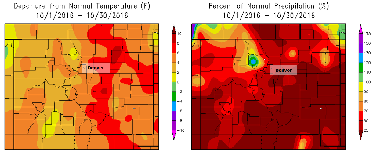
Precipitation and temperature departures from normal for Colorado for the month of October 2016.
We feel like we’re starting to sound like a broken record, but the drought has only worsened. Shown below is how the drought analysis from the National Drought Mitigation Center has changed in the last thirty days…
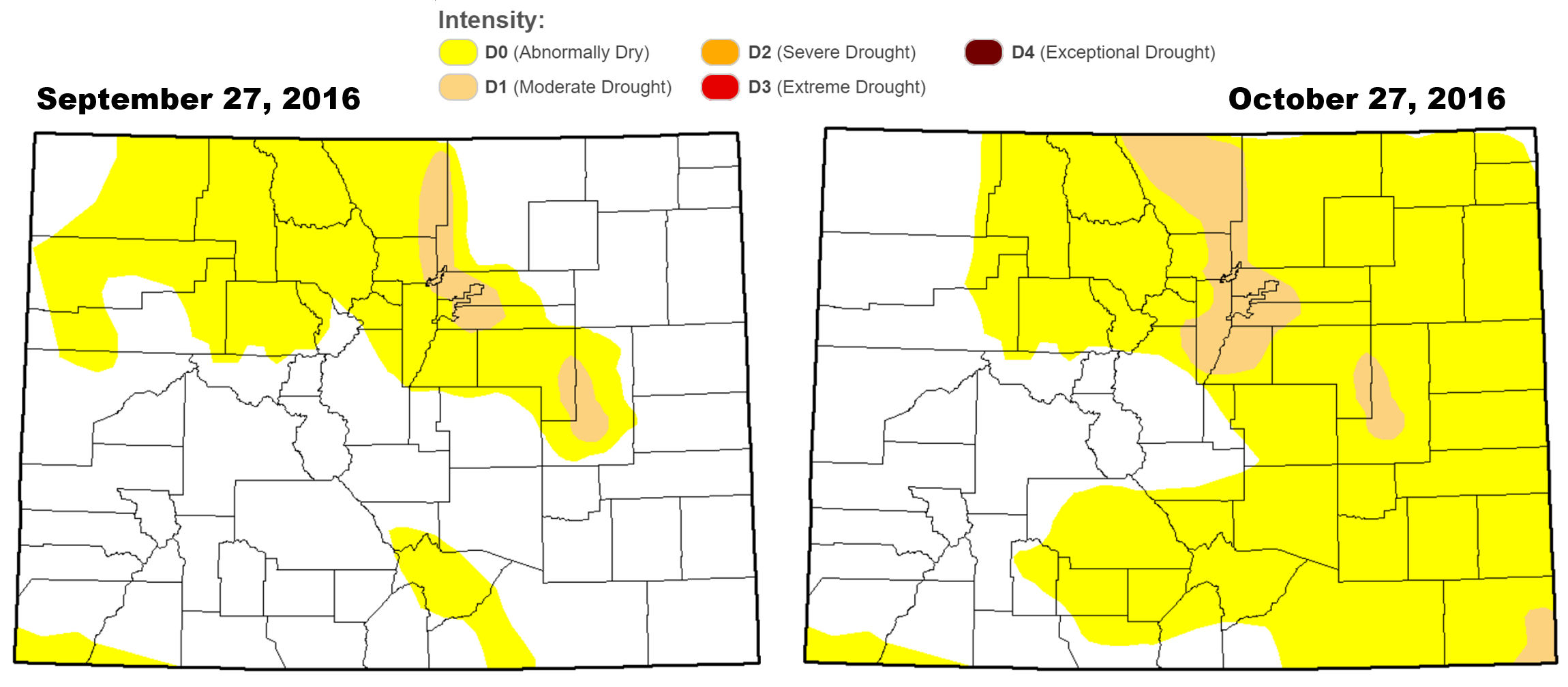
6% of Colorado is now experiencing Moderate Drought, including most of the Front Range. While this doesn’t sound like much, due to the overlap of the drought with major population centers, this small area of drought covers more than 40% of our state’s entire population!
We expressed our disapproval and surprise in our October outlook when all the Front Range counties revoked the fire ban that was enacted back in July. Sure enough, many locations have since reinstated the ban, including Boulder County. The current restricted area is highlighted below in a fiery shade of red. Fuels are dry out there. Very dry.

If you recall, our October 2016 outlook called for near normal temperatures (wrong!) and below normal precipitation (spot on!) for the Denver Metro area. Here’s how some various inputs into our forecast panned out:
- ENSO: We expected neutral ENSO conditions to persist in the Equatorial Pacific, which they did. With this, the influence of ENSO on Colorado’s October weather is very minimal, though we did mention there was a slightly increased chance of above normal precipitation for the month (not statistically significant)
- Weather Model Ensembles: The ensembles nailed the first 15 days of October fairly well for the region. We discussed the cooler weather at the beginning of the month (remember that potential snow day?) would be counter-balanced by ridging through the middle of the month and beyond.
- CFS Climate Model: The CFS had almost all of North America under very warm conditions (verified!), but depicted mixed signals across Colorado, with just a slight indication of below normal precipitation for the Front Range.
- BoulderCAST Analog Forecast: Our own hand-crafted analog forecast pointed to below normal precipitation for the entire state (woo!), but gave no guidance for temperatures.
- NOAA’s CPC: NOAA had the Front Range in elevated chances of above normal precipitation (very wrong!) and temperature (correct!).
Shifting focus to the next month…normally, November across the Front Range is cool and sunny with snow becoming more common than rain. Let’s take a closer look!
November Precipitation History:
On average, Boulder receives 1.16″ of precipitation in November.
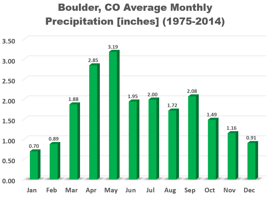
Most Novembers have less than 1″ of precipitation, however, in 1946, 3.68″ was recorded, solely contained in 48″ of snowfall! Yikes! Speaking of snowfall, or a lack thereof this year, don’t be too worried. Our first snowfall actually holds out until November one out of every four years. We have NEVER made it all the way to December without some white stuff on the ground, so odds are extremely good that we’ll see our first snow in the next thirty days.
Click here to see when you all, the readers, think our first snow will occur this year. There’s only a few guesses left that could verify (but likely won’t).
November Temperature History:
Leading into winter, November continues the downward trend in temperature for the region. The average high temperature slowly declines from 57 degrees on the first of the month, to just 50 degrees by November 30th. Mean overnight lows are below freezing every single night in November. This fact really puts the recent warmth into perspective. Frost and freezes should be the norm already, when in fact, we’ve barely had but a couple.
The hottest temperature during the month of November was 79 degrees, observed on November 4, 1952. On the 27th of November in 1919, the temperature dropped to a icy -12 degrees. A rather sizable spread.
This Year’s November Outlook:
Below we review several factors individually that we take into consideration for our outlook of November.
EL NIÑA / LA NIÑA:
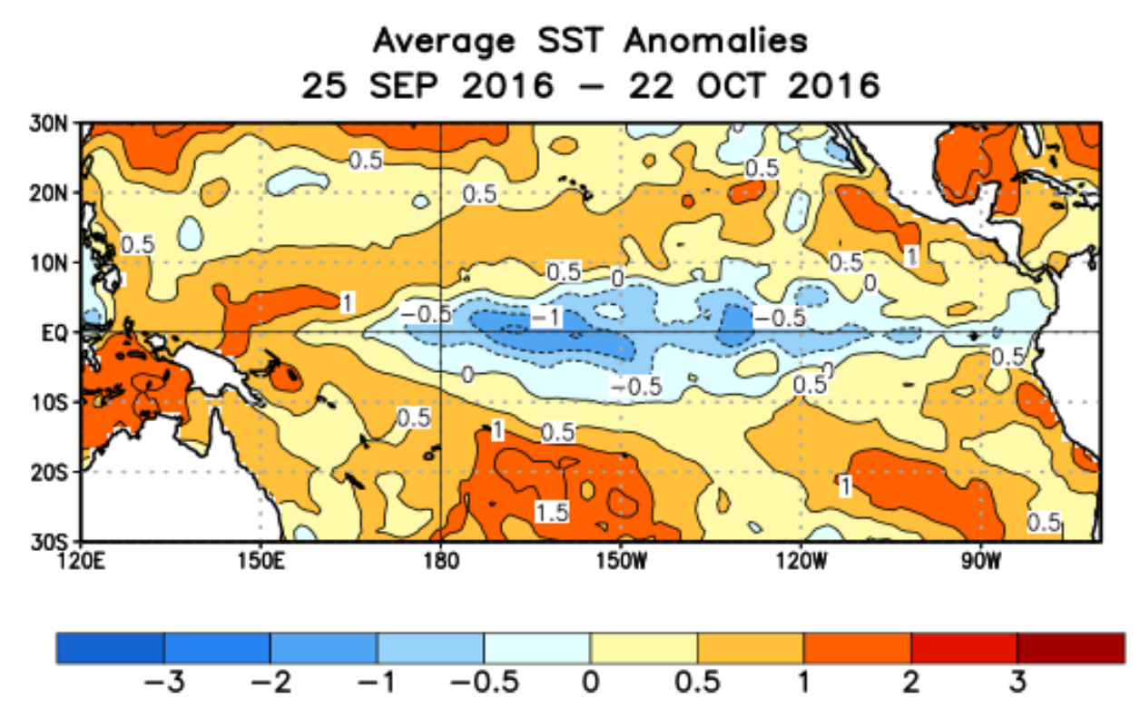
The equatorial Pacific Ocean remains on the brink of shifting into a La Niña phase for the first time in four years. The graphs below show sea-surface temperature anomalies for various regions spread across the Pacific. Though the historic El Niño of last winter has been vanquished and is transitioning into a weak cold anomaly, little change has occurred in the last FOUR months.

Current temperature anomaly plots for four regions of the equatorial Pacific Ocean
Arguably the most important region, NIÑO 3.4, has been hovering around -0.5 degrees since mid-June. This value is on the cusp between ENSO neutral and a weak La Niña. The mean ocean temperature anomalies for the last 30 days are shown below. Definitely has the appearance of a La Niña (cool water straddling the Equator).
Looking forward, climate model forecasts now almost exclusively develop weak a La Niña through the winter, transitioning back to neutral in the February-March time-frame.
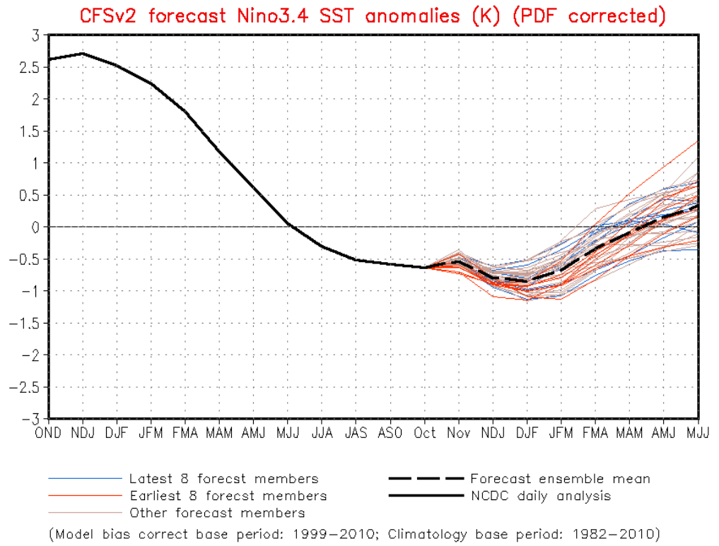
Model ensemble forecasts for Nino 3.4 region temperature anomaly.
Based on our ENSO analysis, assuming we do shift into a weak La Niña for the month of November, we found the odds of a wetter than normal month are slightly increased, with also slightly elevated odds of a colder than average month. Truth be told though, obtaining useful insight from ENSO during this weak phase is an uphill battle in Colorado during the fall months. Therefore, we’ll weigh this information lightly.
WEATHER MODELS:
Not surprisingly, ensemble models shows the large ridge that has dominated our weather for several months now continuing to remain in place for the first two weeks of November. Under this pattern, warm and mostly dry conditions will remain. Snow on the Plains would be difficult, but not impossible. However, around the middle of the month, the ridge may slide westward, opening the door for cold air to invade the central and eastern USA. Colorado may be able to get in on this action if this happens.
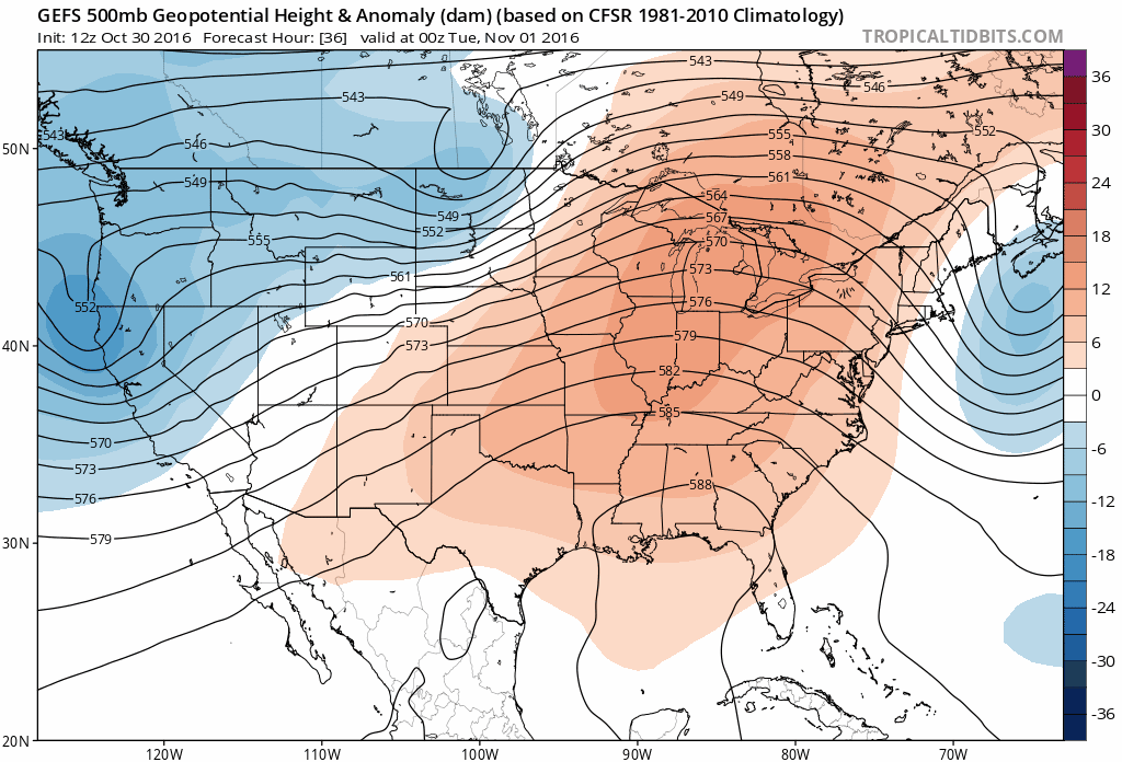
GFS ensemble forecast for 500 mb height through mid-November
CLIMATE MODELS:
We often consult the Climate Forecast System long-range model to help guide any potential forecast for the upcoming month or season. As you can see below, similar to last month, the CFS model is thinking very warm for much (if not all) of the continental United States, including eastern Colorado. For precipitation, the model doesn’t lean either way of normal.
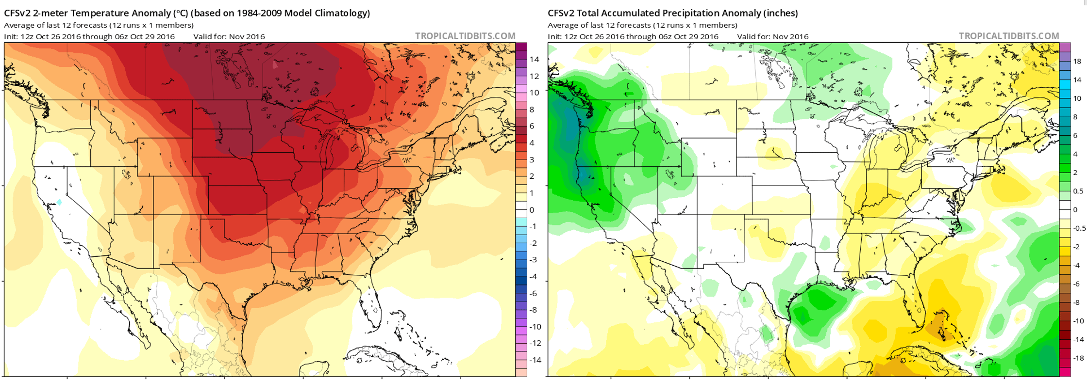
Climate Forecast System outlook for November’s temperature (left) and precipitation (right) anomalies.
There is a striking lack of cool anomalies (blue) in the left map. The CFS really believes almost all of North America is in store for a warm November. In the right map for precipitation, notice that Colorado lies in between the soggy Pacific Northwest and the dry Southeast United States. This lends little confidence to precipitation input for our region from the CFS model (i.e. it could go either way).
BOULDERCAST ANALOGS:
Based on what 2016 has dished out recently, our algorithms choose the top ten historical analogs (years that thus far have been most similar to 2016 in regards to temperature and precipitation for the Front Range). They point towards this November being cooler than normal, with no information about Front Range precipitation.
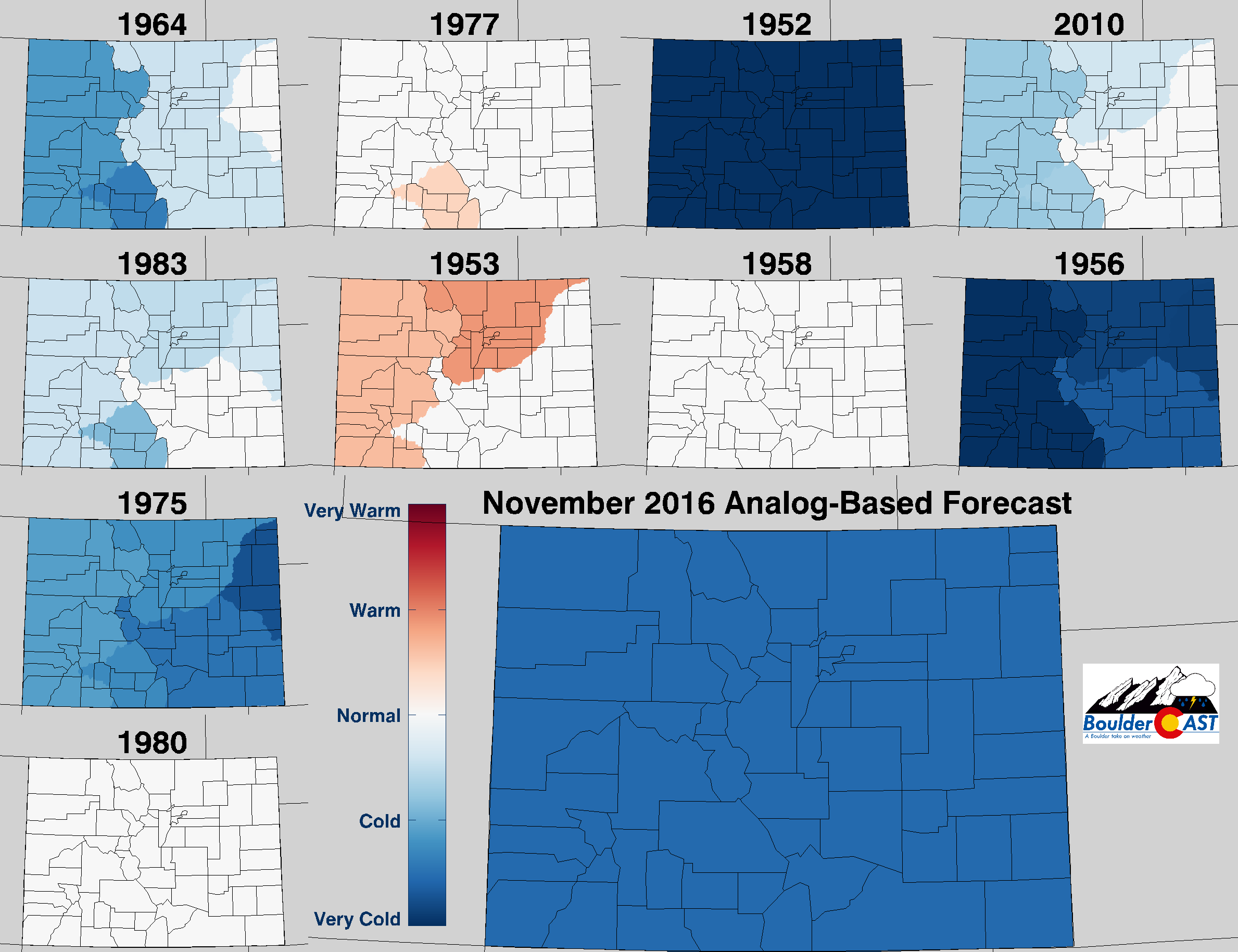
Top 10 Analogs to 2016 and how those years played for TEMPERATURE in Colorado during the month of November. The large map shows the analog-based weighted consensus forecast based on those 10 years.
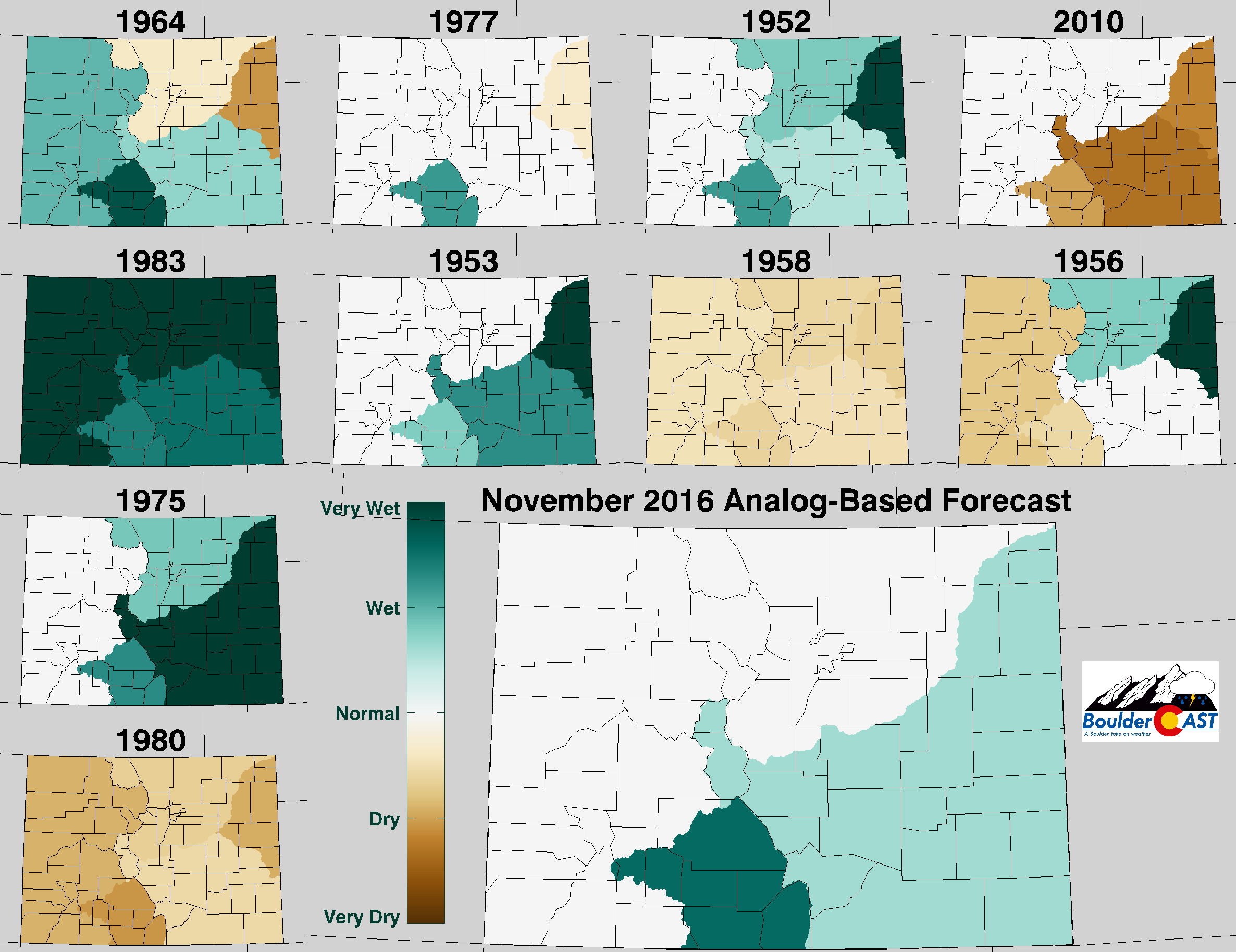
Top 10 Analogs to 2016 and how those years played for PRECIPITATION in Colorado during the month of November. The large map shows the analog-based weighted consensus forecast based on those 10 years.
There is a stark shift in the weather patterns visible in our analogs. For years similar to this one, with extremely warm and dry late summers/early autumns, November turned the tide. As you can see, 6 out of the top 10 analogs had cooler than normal Novembers in the Front Range. Only one analog year was above normal. Despite most other indication pointing towards this November being warm, the analogs say otherwise and this bears some consideration.
NOAA’S CLIMATE PREDICTION CENTER:
The Climate Prediction Center puts all of Colorado with high odds of above normal temperatures in November. They rarely use the 70% designation, so they must believe very strongly in this forecast. They also have the Denver Metro area in a swath of slightly elevated chances of below normal precipitation.
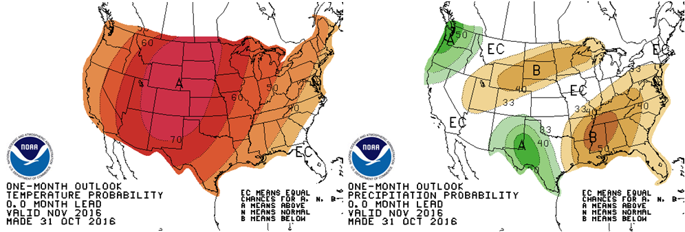
Climate Prediction Center outlook for November’s temperature (left) and precipitation (right)
IN SUMMARY…
Considering all of the aforementioned factors, BoulderCAST is predicting warmer than normal temperatures for November with near normal precipitation for the Front Range.
We believe the models have a good grasp on the warm/ridgy nature of the first two weeks of the month. However, it’s hard to go against the analogs bringing big changes for the latter half of the month, with much colder conditions and a more active weather pattern. Our prediction is that the warmth early on will outweigh the cooler weather on the backside of November. We think most precipitation will fall in the form of snow, which would put us in the 8 to 14″ range for the month.
With that said, get your snow shovels ready. Our first taste of white stuff could be right around the corner!


