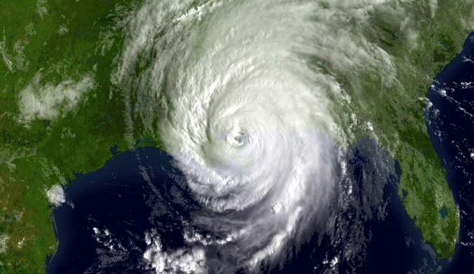
Last summer, the story was an El Niño-induced lull over the Atlantic Basin, but as we discussed in an article last week, El Niño is officially gone. What exactly does that mean for tropical activity in the Atlantic? Are there other climate signals that might govern this year’s tropical development? We bring you up to speed on the 2016 Atlantic Hurricane Season and our expectations moving forward.
2016 Atlantic Tropical Cyclones
The 2016 hurricane season commenced with Hurricane Alex, an atypical tropical cyclone that developed over the northeastern Atlantic roughly 1000 miles west of the African continent back in January. While we do not normally expect tropical cyclones mid-winter, it is not the first. In fact, Alex became the seventh such storm to live in January and the first since 2005. It harmlessly traveled northward eventually meeting its demise over colder waters. We then had another off-season surprise with Tropical Storm Bonnie developing in late May. Finally, we had two weak tropical storms named Colin and Danielle in June, for which our total currently stands at four.
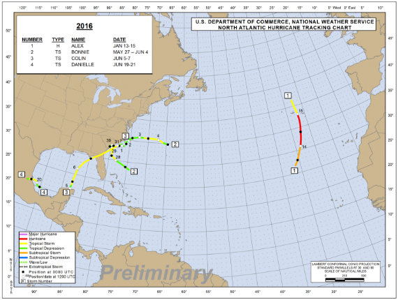
2016 tropical cyclone track chart for the Atlantic Basin. Four named storms thus far…
Why this may be an active season
A dying El Niño means declining sea surface temperatures (SSTs) for the equatorial Pacific waters, meaning a reduction in wind shear potential for the Atlantic Basin. Considering this and with sea surface temperatures already in the low to mid 80’s for much of the western half of the Atlantic Ocean (1-2 degC above average), we will continue to watch SSts rise through September and October meaning more unimpeded low-level instability for the Atlantic Basin and thus more opportunities for tropical development.
Why this may not be an active season
The Pacific Decadal Oscillation remains in a positive phase, meaning the SSTs for much of the eastern Pacific are above average. It is possible that these anomalously warm SSTs can contribute to wind shear across the Atlantic. The figure below shows streamlines at 250 mb. Oranges, reds, and pinks show the west-east movement of jet streams. The subtropical jet stream is represented by the orange color located over Mexico and south-central United States (outlined by the red arrow). This plays a significant role in wind shear generation for tropical cyclones. If we see a continuance of the subtropical jet stream at this magnitude, it could limit the number of named tropical cyclones we see this season. Furthermore, this added wind shear could facilitate the formation of cold-core low-pressure systems that would decrease SSTs due to a reduction in solar heating from increased cloud cover in the region.
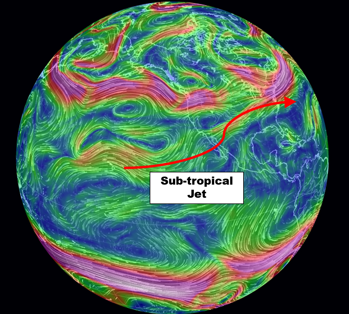
Current 250mb wind streamlines across the planet. We highlight the position of the subtropical jet
You can find figures like the one above here.
The following two figures show actual SSTs and anomalies on our planet as of July 2, 2016.
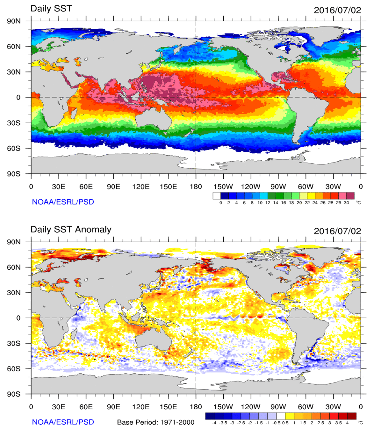
Current sea surface temperatures (top) and anomalies (bottom) as of July 2, 2016
At this time, the biggest features to keep an eye on are:
- the developing cold SST anomalies over the equatorial Pacific (La Niña)
- the warm SST anomalies over the waters just west of Mexico and the southwestern US
- the SSTs and SST anomalies over the entire Atlantic Basin
The first feature is very likely according to predictions from the vast majority of climate models (see last week’s post). While the latter two are a little more uncertain, the current PDO Index indicates a slight downward trend in a weak positive signal. Does this signal mean anything for tropical cyclone development? Does a correlation exist between drivers from both PDO and ENSO? More research is required to address this topic further, but we will be monitoring these relationships throughout the entire 2016 Hurricane Season.
Current weather features
The weather features tropical meteorologists typically look for are the location of the Bermuda High pressure center, midlatitude cyclones and associated fronts (both are steering mechanisms for tropical cyclones), and of course areas of potential tropical cyclone development. As expected for this month in the season, areas of ideal tropical development are restricted to waters south of 30 degrees north latitude due to strong upper-level westerly winds associated with the polar jet stream. The Bermuda High is currently centered over 30N latitude 44W longitude, which puts it over the central North Atlantic Ocean. The primary low-level flow currently allows tropical waves to move off the African continent, but the higher likelihood for tropical development is closer to the United States where the warmest waters are located. Areas of expected tropical activity will expand as we move into August (see below).
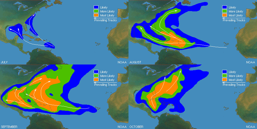
Location of likely tropical cyclone formation in the Atlantic Basin from July into October (based on climatology)

Current surface map/satellite (left) and 500 mb map for the Atlantic Basin
Northwest of the Bermuda High is a surface low with a front draped over the east-central United States, northeastward into the Atlantic Ocean. Over the next couple months, expect frontal activity to shift northward, giving way to more favorable conditions for tropical cyclone development. At this time, we are monitoring two disorganized areas of convection associated with tropical waves south of 20N (shown in figure on left) latitude traveling westward. Development is not expected from either region. Notice the 500 mb winds (right figure above). The strongest winds are associated with a mid-level trough responsible for the surface low. If conditions remain the same over the Atlantic Basin, we would expect the most likely area for development south of the Caribbean islands and west of the Lesser Antilles. Expect no major development over the next 48-72 hours, likely longer.
Atlantic Hurricane Season Forecast 2016
The deteriorating El Niño will certainly increase tropical cyclone development over the Atlantic Basin. But by how much?
| Colorado State* | NHC^ | BoulderCAST Forecast | |
| Named Storms | 15 | 10 to 16 | 13 |
| Hurricanes | 6 | 4 to 8 | 5 |
| Major Hurricanes | 2 | 1 to 4 | 2 |
| *Issued July 1, 2016 | |||
| ^Issued May 27, 2016, 70% likelihood of confirming | |||
Both Colorado State University’s (CSU’s) Department of Atmospheric Science and the National Hurricane Center (NHC) expect more activity this year, but slightly differ in the numbers. This discrepancy is no surprise given the uncertainty in the transition from El Niño. Given the above average current and forecasted SST anomalies holding on strong over much of the eastern Pacific, we are not quite as optimistic as Colorado State about the number of named storms, but line up closely regarding the number of hurricanes and major hurricanes.
Factoring this, we think wind shear will limit the number of named storms below CSU’s forecast and will line up relatively close to the median of NHC’s numbers. Given the current southerly position of the Bermuda High, we believe there is a 50/50 chance for a United States hurricane landfall to occur, especially over the Gulf of Mexico and south Atlantic coast. Although the subtropical jet stream remains in place for now, its affects on the Gulf of Mexico and Caribbean will continue to decrease as we move into August and September. This will warm these waters and keep upper-level winds favorable for tropical cyclone development!
—
We close our tropical forecast out with one final statement. For those Coloradans vacationing in tropics, be alert for hurricanes and adhere to any warnings in the safest manner possible. If you have any questions about our analyses or about tropical meteorology in general, feel free to leave a comment for me, Matt Steiner. Happy hurricane tracking!


Can you explain further the details of how warm SSTs in the Pacific affect wind shear in the Atlantic? It was mentioned as a know relationship, but no further details of exactly how it works was given. Thanks!
There is one known driver and a second factor that has not been researched as much. The first is the positive phase of ENSO (aka El Nino), where the central equatorial Pacific sea surface temperatures are warmer than average. The second is warmer SST’s than average in the north-northeast Pacific from the Pacific Decadal Oscillation. This relationship has been explored very little, however some skepticism does exist about the PDO’s role in Atlantic topical cyclone activity.
Warmer waters generally strengthen the subtropical jet stream, which generates unwanted wind shear for tropical cyclone development. Again, confidence behind the relationship between El Nino and a strengthened subtropical jet stream is quite high, whereas confidence between the PDO’s role in the strengthening subtropical jet stream is still unknown. However, it does beg to question why we see fewer tropical cyclones during some non-El Nino year scenarios.
-Matt
P.S. Sorry for delay. My comment was, ironically stuck in the spam filter.