As the nation braces for impact of another major tropical cyclone, we update you on the status of Hurricane Irma. Where is she headed and when will she arrive? Read on to find out.
DISCLAIMER: This update was created Wednesday, September 6, 2017. Any life-sustaining decisions regarding Irma should be made on your own accord following the most up to date guidance from the local emergency authorities.
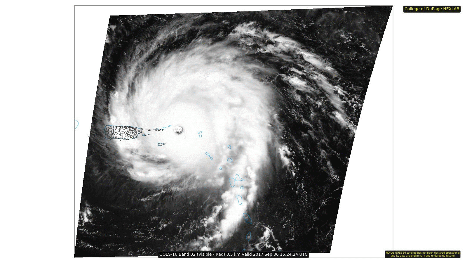
Click for the amazing full-resolution animation!
Current status
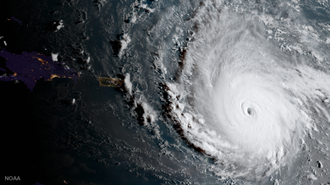
Hurricane Irma is currently located just east of Puerto Rico and has sustained winds of 185 mph. No doubt there are gusts exceeding 210 or 220 mph at its core. This is Category 5 status and within reach of becoming the strongest tropical cyclone ever documented on Earth. The storm is chugging westward towards Florida and Cuba and is set to potentially make landfall this weekend, likely as a slightly weaker Category 3 or 4 storm.
Earlier today, Irma’s eye passed by a NOAA buoy across open water. You can see the wind speed jump to 135 knots (155 mph) before the wind data cuts out (red line). It’s likely that the anemometer was completely destroyed! We also can see the sea-level pressure drop to 27.20″, equivalent to 920 mb!
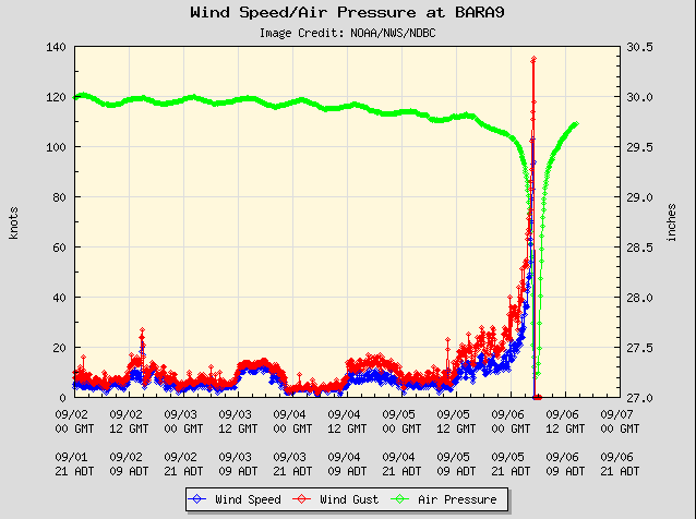
Buoy near Barbados that was in the direct impact of Irma last night. The insane winds and central pressure drop in the eye are visible.
Track outlook
Early track projections for Hurricane Irma took the storm into Cuba, then the Florida Strait, then the Florida Peninsula itself. Many media sites have been treating these track forecasts as FACT for several days now. A prime example…all of Florida has already been declared a state of emergency! The determining forecasts were still five to seven days out. We all know trusting us meteorologists that far in advance is a BIG no-no. This is almost like Denver completely shutting down roads and schools for a snowstorm that is seven days away. The kiddos would sure enjoy that!
In our weekly outlook yesterday, we detailed how highly uncertain model forecasts were given the driving atmospheric factors at play. The large trough across the eastern United States was our biggest concern. This is ultimately what has been responsible for Irma’s track adjusting further northward over the last few days. This shift is actually a good thing, in my opinion. If Irma had successfully navigated the Florida Strait and made it into the warm waters of the Gulf of Mexico intact, the Gulf Coast states would have been in serious trouble again, less than two weeks after Harvey.
The forecast map below for upper-level winds this weekend shows the likely impact the trough will have on Irma. West-southwesterly winds will be turning the storm northward and providing a pardon for those states that were impacted by Harvey. There is virtually no chance of the storm making it into the Gulf now. It’s actually quite ironic that a tropical cyclone, with winds at its core of 185 mph, has a track that relies so heavily upon ever-so-slight shifts in the nearby approximately 10 mph winds in the middle layers of the atmosphere!
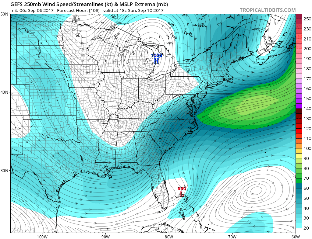
GFS ensemble forecast upper-level wind speeds and streamlines for Sunday.
As of Wednesday afternoon, latest model guidance less strongly suggests a landfall in Florida. The storm could potentially be eyeing Georgia or the Carolinas. A few of our friends in the Southeast states ONLY trust the European model for their hurricane track forecasts. This mindset is likely due to the last few nearby hurricanes being relatively well forecast by the Euro in advance and against all odds (Matthew, Joaquin). If it is any consolation, the Euro and American GFS are in decent agreement of Irma skirting the eastern Florida coastline and then making a somewhat direct landfall in South Carolina or Georgia. The GFS ensemble tracks are shown below (left) along with the latest track cone from the National Hurricane Center.
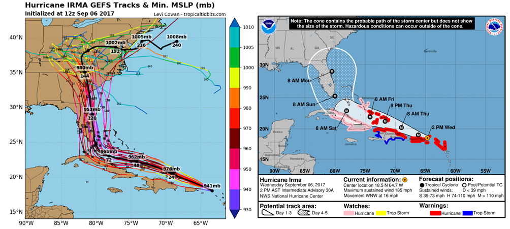
GEFS forecast ensemble track forecasts for Irma (left) and the National Hurricane Center track cone (right).
This track forecast is inherently difficult due to the HARD right turn Irma will make sometime on Saturday. It’s still too early to say for sure, but there is a better chance that Florida will be spared from a land-falling eye than this time yesterday. Here is the latest HWRF (Hurricane WRF) model wind speed forecast showing the eye just offshore from the Florida coast on Sunday night.
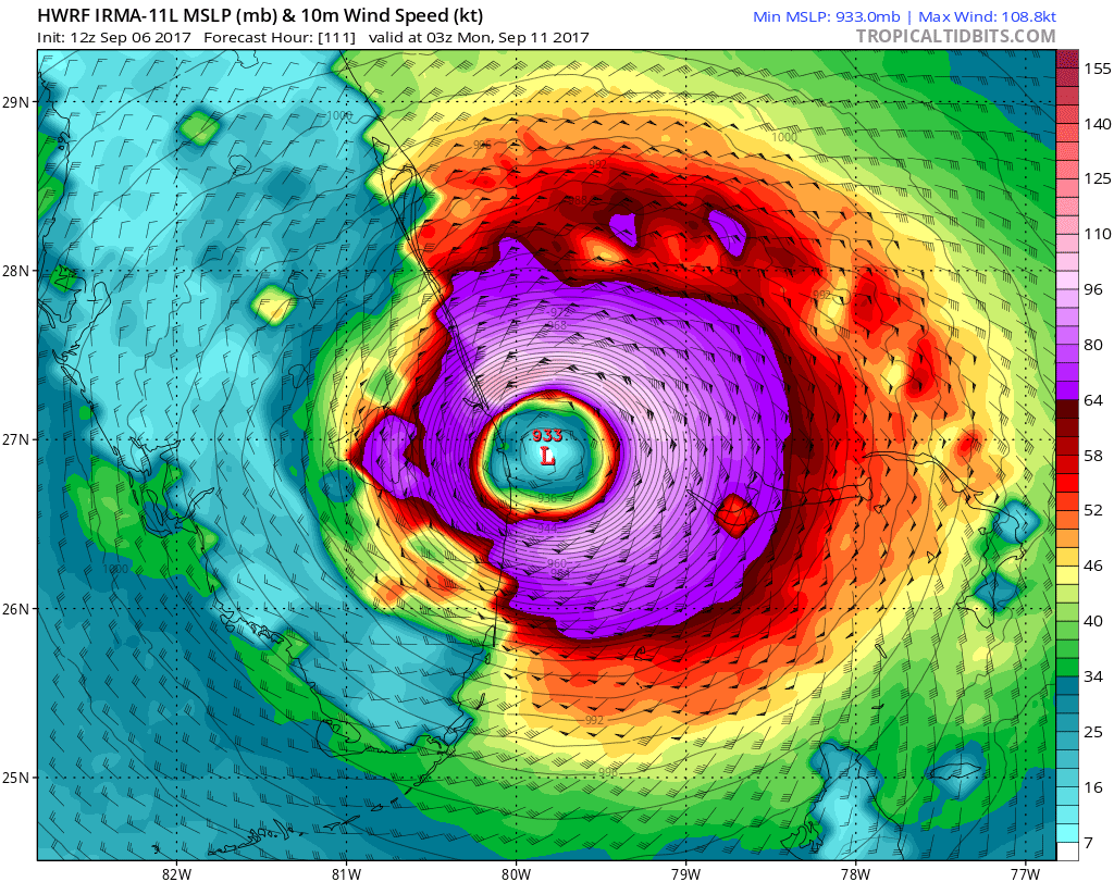
Pressure and wind speed forecast for Irma Sunday night from the HWRF model.
Note that the “recurve” north (and potentially east) on Irma’s track has been growing with each model run. While unlikely, it’s still not entirely out of the question that it doesn’t make landfall at all and tracks out to sea past the North Carolina coastline. This all would be happening on Monday or Tuesday next week.
Keep in mind, Florida is by no means out of the woods. Even without making a complete landfall, the western edge of the eyewall would rake the eastern coastline, similar to Hurricane Matthew last September. Hurricane force winds and significant storm surge are HIGHLY LIKELY from Irma, regardless of the eventual track. The impacts will be substantial and devastating.
Prayers are with our friends and readers in Florida. Stay tuned….
.
This is epic free content.


