
A powerful, slow-moving system is still on track to impact the region through the weekend. The Foothills are undoubtedly set for massive snow totals, but uncertainty remains in exactly how much the lower elevations will pick up. We summarize recent model trends and give a forecast update on this upcoming historic weather event.
Over the last 48 hours, the models haven’t wavered at all with this system. The main facets which we detailed in our last post are still on track.
- A strong cut-off, upper-level low pressure will move from Oregon into the Four Corners by Friday evening, at which point it stalls indefinitely
- The location of the upper-low will be near perfect for wringing out the plentiful Gulf of Mexico moisture across NE Colorado
- With the storm remaining near stationary for 2 to 4 days, an extended period of moderate precipitation will fall across our region
- The air will definitely be cold enough for all snow in the Foothills, which will equate to historic snowfall for locations above ~6,500 feet. The Plains are a little more ambiguous…
The latest GFS meteogram shows an extended period of deep northeasterly upslope (top panel, circled), and near continuous moderate precipitation through the weekend, heaviest Saturday into early Sunday (bottom panel).
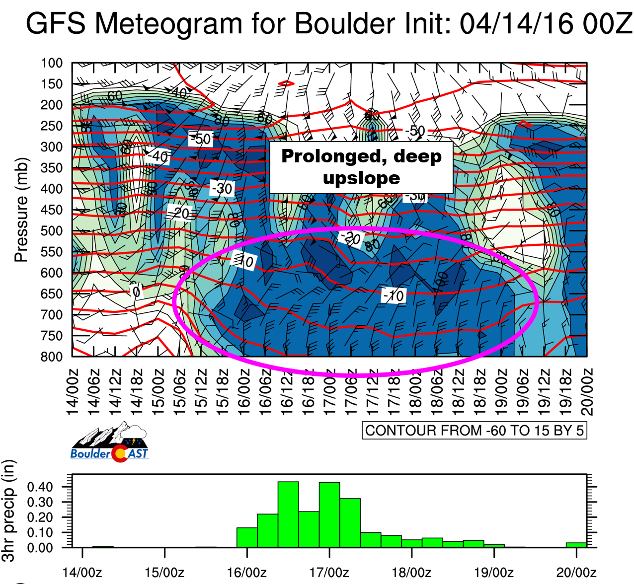
GFS meteogram showing wind barbs and height (top panel) and accumulated liquid precipitation per 6 hour increment (bottom panel).
As such, the entire Front Range will be within a broad shield of continuous precipitation from Friday afternoon into early Sunday morning.
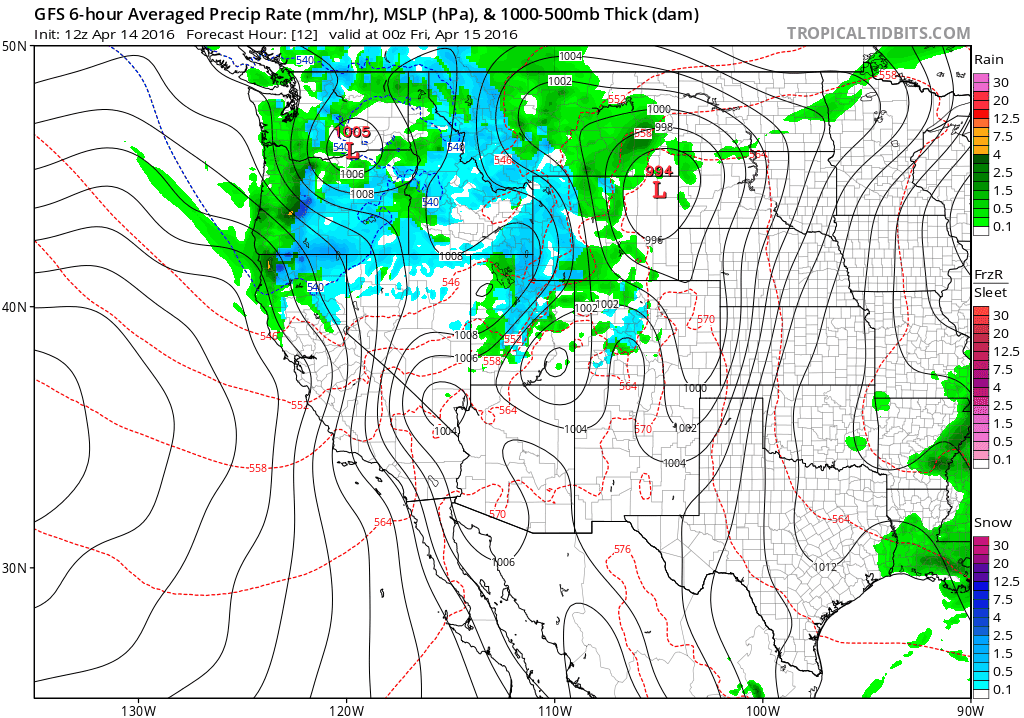
GFS surface storm track and development through the weekend, showing the extended period of precipitation heading for the Front Range.
By the end of the weekend, 2 to as much as 5 inches of liquid are projected for the region, with the highest amounts over the Foothills of Boulder and Larimer Counties (seen below). Though the event will be spread out over a few days, some localized flooding will be possible with totals this significant.
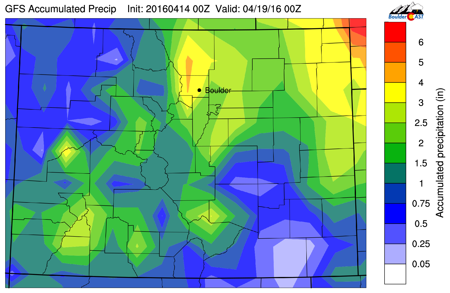
GFS forecast total accumulated liquid precipitation through Monday. Big totals expected for all of NE Colorado.
This has been very consistent in nearly every run of every model, so confidence is high as far as pinpointing the areas that will be hit hardest. The more difficult forecast will be predicting how much snow will fall across the Denver Metro…
Colder and snowier
The big change since our last update has been an overall cooling trend with the system, which has increased the likelihood of snow falling down on the Plains. At this time, we have about 95% confidence that Boulder/Denver will see snow at some point over the weekend. Uncertainty still remains in how much snow will fall, and precisely where. The cold air is marginal, and with temperatures in the 30’s, a few degree shift either way can make all the difference.
Areas on the Plains closer to the Foothills will have a higher likelihood of accumulating snowfall. We’re expecting a full change-over to snow from rain on the Plains to occur sometime Saturday. There might be some snow mixing in as well late Friday night. The coldest air doesn’t arrive until Saturday evening and night, though. Depending on exactly when this change-over occurs, and if we can get near or below the elusive 32 degree mark, will determine snow amounts. We’re also monitoring the potential for a dry slot to move into the Denver area Sunday morning. This feature is present in most models, but the magnitude and location vary. This is vital because Sunday is when the coldest air will be in place. If the precipitation can continue, there is a good chance it would be in the form of snow, adding to lower elevation totals.

GFS pressure and precipitation map, valid Sunday morning. A potential dry slot may limit precipitation across eastern Colorado Sunday.
In the Foothills, it will be all snow from Friday evening through the duration of the event. The colder trend in the forecast has lead to higher snow-to-liquid ratios. This will produce fluffier, and greater snow totals overall for the higher elevations, bordering on ridiculous territory.
Here is the timeline were currently looking at:
- Friday: A cold front arrives in the early afternoon. Showers developing across the higher terrain late morning, expanding onto the Plains through the afternoon with increasing coverage and intensity. Snow levels will begin high, near 9,000 feet, but will be falling through the day, especially into the Friday night where some snow will mix down to the Plains as well. Strong to severe thunderstorms will be possible southeast of Denver towards the Kansas line during the afternoon.
- Saturday: Precipitation continues, heavy at times, through the day. During the day, it should be mostly snow fore everyone, but some rain could mix back in on the Plains, with all snow above ~6,000 feet for sure. We’re expecting a colder push of air sometime Saturday, but it is subtle. When that happens, the snow will have a better chance of piling up. Heavy wet snow accumulation will be possible in Boulder and Denver Saturday evening and night. This is when the greatest threat for power outages will exist.
- Sunday: Depending on how the dry slot materializes, precipitation could cease Sunday morning and afternoon, especially from Denver east. It will likely continue in the Foothills through the day as moderate snow.
Preliminary expectations for accumulations:
- Foothills: With 48 to 72+ hours of near continuous snowfall, look for massive snow totals above ~6,500 feet. 18 to 36+ ” inches are likely over the course of the weekend. Locally higher amounts in excess of 4 feet are definitely not out of the question! This truly is a historic storm for the Foothills. Bunker down and stay safe! Enjoy it!
- Plains: We are thinking 6 to 15″ of snow for the lower elevations right now through Sunday, including the Boulder and Denver areas. A bulk of this would be on grassy surfaces. There will be A LOT of melting out there during the day Saturday, so we’re not entirely sure how much will stick and what the depth on the ground might be at any given time. There is widespread foliage out there, so power outages will be likely Saturday night if we push towards the high end of this range. With the late April sun, roads may become caked with thick slush across the region, marking for tricky travel.
This system compares nicely to a late season snow storm in Boulder back on April 23-26, 1997. A very similar tracking low cut-off in a near identical location in northwest New Mexico. Precipitation lingered for days, with 19″ of snow falling in Boulder, and much more in the higher elevations. This came from ~3.5″ of liquid. There was periods of rain and snow, with significant melting occurring. And just like this weekend’s storm, temperatures were very warm (near 70) the day before it all began. Boulder and Denver will be near 80 degrees this afternoon…
Stay tuned for a busy next couple of days!
Whew! That was a dump of information! Needless to say there is still a lot that can happen between now and Friday evening. We’ll post another update tomorrow with our snow accumulation map. There should be more clarity for the lower elevations by then. Stay tuned and subscribe for instant email notifications for our updates! It’s going to be a wild ride!


