Let us be the first to welcome you to fall! That’s right…summer is no more, at least to us weather folks. September 1st marks the beginning of meteorological autumn. Picture-perfect weather has been a mainstay throughout the summer, which is both good and bad. The monsoon plume has largely been confined to our south and west, keeping the Front Range relatively parched, leading to dry and at times, dangerous fire conditions. Will this trend continue into September? Read on as we examine Boulder’s climatology and consider the current state of the atmosphere to give our outlook for next month.
Recapping August
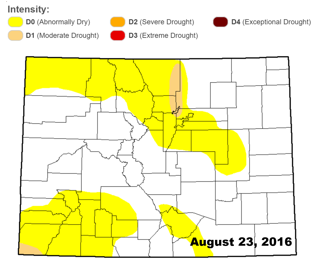
Two months ago we were concerned that Colorado could be in store for a dry summer. Then, three weeks ago we informed you that drought had officially returned to the state. And now, we bring news that drought has finally reached the Front Range.
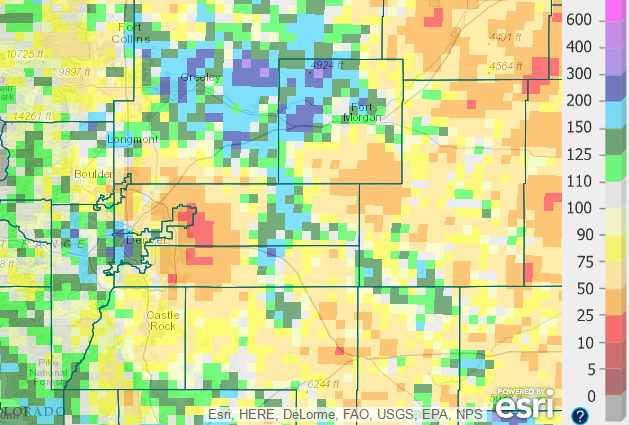
The drought has been spurred by a drier than normal summer, particularly from mid-June through mid-August, when almost no rain fell across parts of the Front Range. There was a slight uptick in precipitation through the ladder half of August. Most areas, though, ended the month well below normal in the rainfall category.
If anything, the above map shows how fickle Mother Nature can be with summertime convective storms. There is a huge disparity from location-to-location. For example, much of downtown Denver reported more than FOUR inches of rain during August (most of which fell over the last week). Remarkably, just 15 miles away, Denver’s official climate station (DIA) recorded less than a half inch (see the red bulls-eye above). Boulder just squeaked past the one inch mark, officially recording 1.06″ (about half of average). BoulderCAST Station came in similarly at 1.11″.
Without the help of more widespread, stratiform precipitation events in near future, we expect the drought coverage to expand. If there is any good news to take away from this, it’s that the drought is fairly small-scale, rather mild, and at this point, is only short-term. It won’t take much for the region to make a recovery!
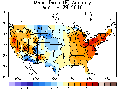
Let’s talk temperatures. Boulder was officially 0.3 degrees below normal in August, despite eleven 90+ degree days. Denver landed more than one full-degree below normal. The first half of August was hot and dry, while the ladder half was cool and, at times, wet. These two polar opposites mostly balanced each other out, with our temperature landing more-or-less near normal (or just below).
Cooler than normal weather we observed in most of Colorado and the northern Rockies in August…
Our warmest temperature was 95 degrees, occurring on three occasions. Our coldest was 43 degrees on August 20th (brr!), which set a record low for the date. With the current state of our climate, it’s difficult to set record cold temperatures. We rarely do it. Consider this year a treat as we had not one, but FOUR mornings with temperatures in the 40’s (something that hasn’t happened since 2009).
Looking ahead, normally September across the Front Range is fairly quiet, as the tail-end of the monsoon comes to a close in the first half of the month, leaving behind generally dry conditions with warm days and cooler nights. Let’s take a closer look if this year could fit this mold.
Precipitation:
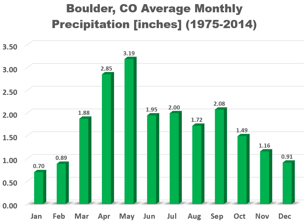
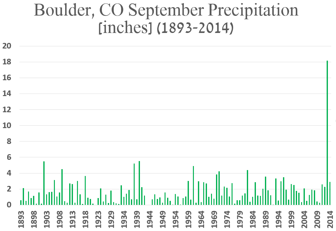
On average, Boulder receives 2.08″ of precipitation in September, technically making it the third wettest month of the year. However, without the 18+” that fell during September 2013, the average would only be 1.45″, actually solidifying September as one of the drier months of the year. Funny how extreme events can throw off basic statistics…
The graph below shows September precipitation totals since record-keeping began in Boulder.
Wow, that really puts the unprecedented rainfall of 2013 into perspective! Check out our special three-year anniversary post commemorating the Boulder Flood. Needless to say, no one should expect that much rain this September!
And of course there is that elephant in the room: snow! Though snow is possible in our higher elevations year-round (as we saw last week), September opens the door for weather systems that are cold enough to potentially produce snowfall on the Plains. Snow has been recorded in Boulder during 27 different Septembers since 1893 (about 1 out of every 5 years), so September snow is not unheard of, or actually even all that rare. Though, admittedly, most September snows are on the light side, usually just a slushy inch or two. However, on September 17, 1971, 21.0 inches of snow fell. Big snows can happen this month! Just two years ago, Boulder recorded it’s earliest measurable snowfall on record, picking up 0.5″ of white stuff on September 12th! That’s right! Our first snow could be less than two weeks away! Realistically, however, climatology has our first snowfall occurring down the road a ways, in early to mid October.
Temperature:
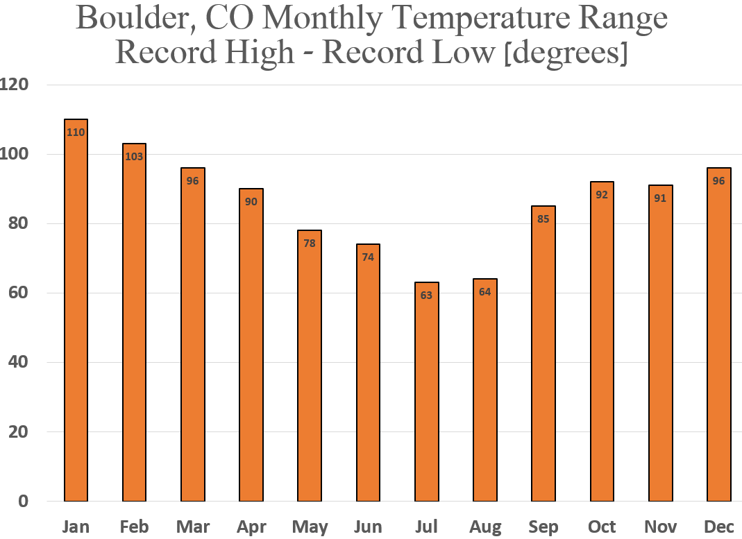
Though most of September is technically part of summer (but commences meteorological autumn…confusing right?), it is definitely a month of transition. The average high temperature plummets from 83 degrees on the first of the month, to just 72 degrees by September 30th. The hottest temperature for the month was 100 degrees, observed on September 2, 1983. On the last day of the month in 1980, the temperature dropped to just 15 degrees. Quite the range of possibilities! We see the disparity between all-time monthly maximum and minimum temperature begin to creep back up in September (see below).
This Year’s September Outlook:
Below we review several factors individually that we take into consideration for our outlook of September.
EL NIÑA / LA NIÑA:
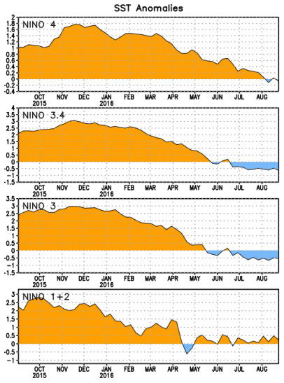
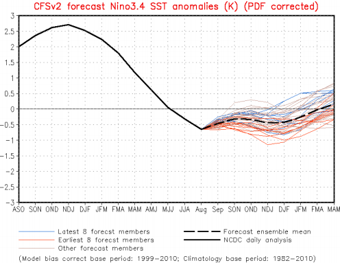
The equatorial Pacific Ocean is on the brink of shifting into a La Niña phase for the first time in four years. The graphs below show sea-surface temperature anomalies for various regions spread across the Pacific. Notice how the historic El Niño (warm anomaly) has been vanquished and is transitioning into a weak cold anomaly (La Niña).
Arguably the most important region, NIÑO 3.4, has been hovering around -0.5 degrees since mid-July. This is right in line with our prediction made two months ago. This value is on the cusp between ENSO neutral and a weak La Niña. Looking forward, climate model forecasts now almost exclusively keep conditions neutral through the winter.
Based on our analysis in that prior post, under neutral or weak La Niña conditions, there is a slightly elevated chance of below normal precipitation during the month of September. Furthermore, Boulder’s median September temperature drops 1.1 degrees during weak La Niñas.
WEATHER MODELS:
The mid-range ensemble model consensus shows a relatively active weather pattern over the western United States for the first chunk of September. As many as two big troughs are slated to impact the region, much more active than is typical for this time of year. By mid-September, models do show things beginning to calm down, but at that point, uncertainty is much greater.
CLIMATE MODELS:
We often consult the Climate Forecast System long-range model to help guide any potential forecast for the upcoming month or season. It infrequently verifies well, but neither do many forecasts speculating what the month ahead will bring. With that said, as you can see below, the CFS model is thinking warm and dry for September across northeast Colorado.
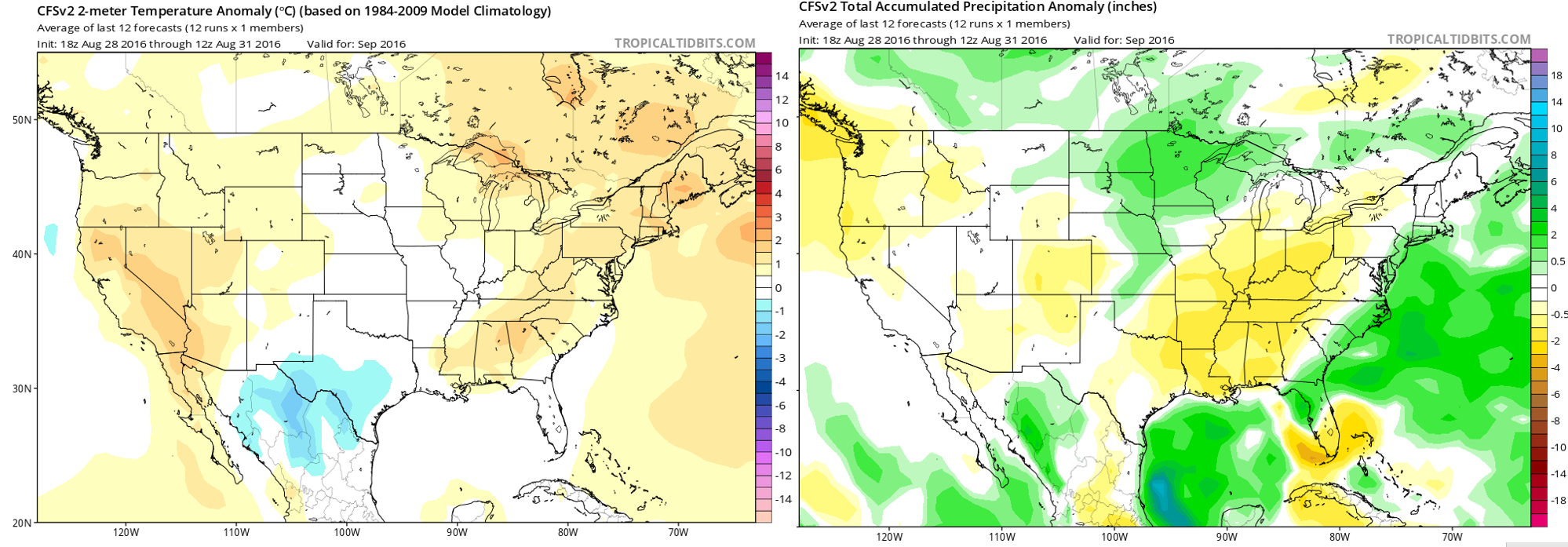
Climate Forecast System model forecast anomalies for September 2016. Temperature (left) and precipitation (right)
BOULDERCAST ANALOGS:
Based on what 2016 has dished out so far, our top ten historical analogs (years that thus far have been most similar to 2016 in regards to temperature and precipitation for the Front Range) point towards this month being slightly cooler and drier than normal.

Top 10 Analogs to 2016 and how those years played for TEMPERATURE in Colorado during the month of September. The large map shows the analog-based weighted consensus forecast based on those 10 years.
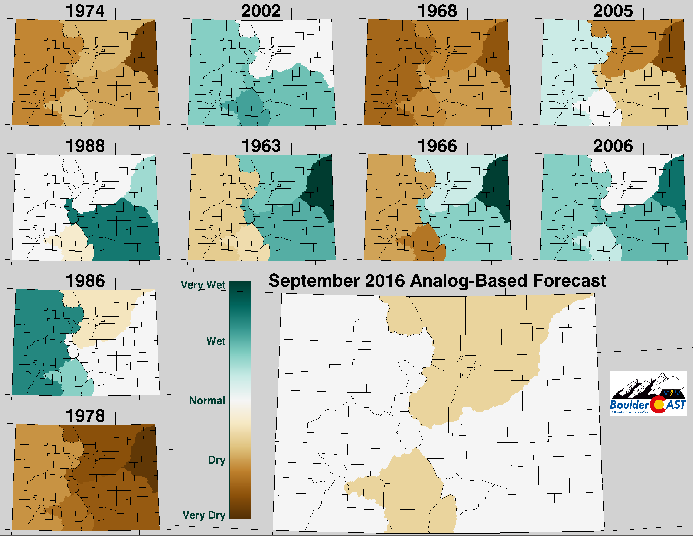
Top 10 Analogs to 2016 and how those years played for PRECIPITATION in Colorado during the month of September. The large map shows the analog-based weighted consensus forecast based on those 10 years.
NOAA’S CLIMATE PREDICTION CENTER:
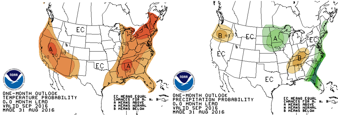
The Climate Prediction Center provides no guidance for Colorado, predicting “Equal Chance” of all three outcomes (above normal, below normal, and near normal) precipitation and temperatures. What do they know anyway?
IN SUMMARY…
Considering all of the aforementioned factors, we are predicting drier than average weather for September with near-normal temperatures.
Hopefully our dry forecast doesn’t pan out, as we sure could use the moisture across our region, which has been turning browner with each passing day. Regardless, get outside and enjoy all that September in the Front Range has to offer, whether it be the scorching heat, the tail-end of 14er season, the yellowing aspens, or the year’s first snowfall! Before you know it, October and “real” Fall will be upon us. Speaking of which, head over to Target or King Soopers to get your Halloween goods, as they undoubtedly already have them in stock. It’s only sixty-one days away, you know.

