After downslope winds warmed us into the 60’s today, another shot of frigid air is headed for the Front Range Friday evening. Snow is commencing in the Mountains already, with the Plains in store for some snow as well. Read on as we detail the arrival of another quick-hitting Arctic system, including timing, snowfall amounts, and projected temperatures.
The Atmospheric Set-up:
As we mentioned earlier in the week, a Friday/Saturday snow event was something we were watching. The storm system of concern will mostly be impacting Wyoming. Winter Storm Warnings are already posted there.
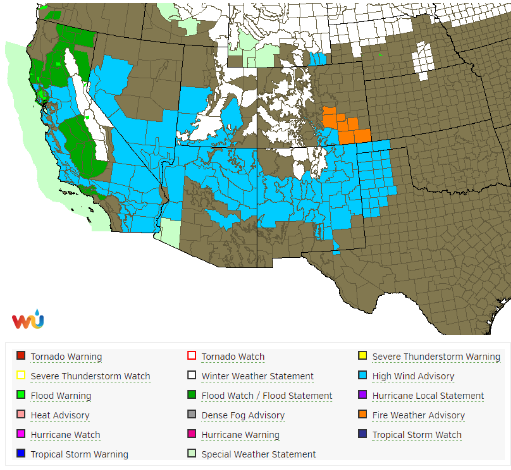
Current weather highlights, showing winter weather advisories in Wyoming and across our Mountains.
However, the Denver Metro area will see snow Friday night as well. In fact, in a lot of ways, this system is quite similar to our prior snow event last week. It’s already feeling like déjà vu from a forecaster’s stand-point…
From a mid-level perspective at 500 mb, the system looks very similar, approaching from the northwest with a positively-tilted trough axis. It’s going to be a quick-mover, with limited moisture (in the low levels, at least). However, a bone-chilling Arctic high pressure at the surface will be feeding very cold upslope into the Metro Area Friday night to get things going.
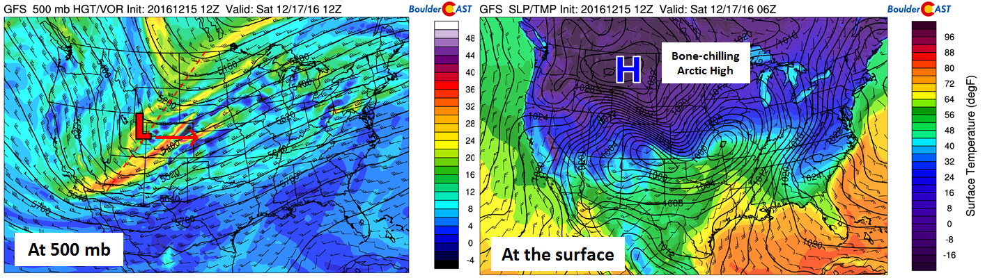
Storm setup at 500 mb (left) and at the surface (right)
At the same time, we’ll have a jet streak passing to our south at the base of the trough. A jet streak is a portion of the jet stream where winds are the fastest. We have circled in RED the jet streak, visible in the 250 mb wind map below. At it’s core, winds exceed 140 knots.
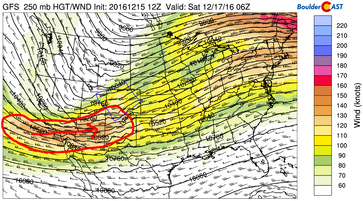
GFS 250 mb height and wind map showing a potent jet streak at the base of the trough (circled in red)
In the map above, we have boxed in BLUE the “left exit region” of the jet streak, which is literally the left side of where air is exiting the jet streak itself. Proven with some complicated math (Google quasi-geostrophic theory, if interested), the jet streak causes additional rising motion in the air of the left exit region (blue box). A simple 3-D representation of the induced circulation is shown below (apologies for the low resolution). Notice the upward part of the circulation in the left exit region.
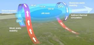
Diagram demonstrating the regions of added lift (and sinking) induced by a jet streak
Inside the blue box, which passes over the Front Range Friday night, a few narrow heavy bands of snow will be possible, thanks to the nearby jet streak.
Once again, similar to last week’s storm, there will be no deep circulation (no real surface low) associated with this system. Therefore, upslope will be shallow and limited to below ~750 mb (~8,500 feet elevation). The NAM model output below shows shallow upslope in place (5 -15 knots) Friday night and Saturday morning.
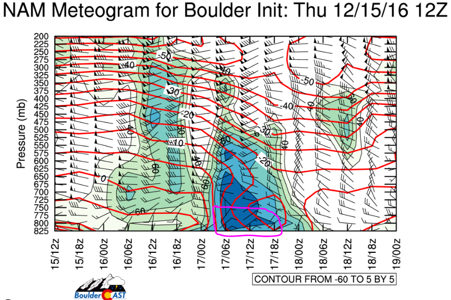
NAM model meteogram, showing shallow upslope Friday night
Above the 750 mb level, winds remain west-southwesterly the entire time. With plenty of Pacific moisture in the mid-levels, this will wallop the Mountains with heavy snow from late Thursday night into Friday night. Some of this will spill over into the higher Foothills east of the Divide along Peak to Peak Highway.
Timing
After highs quickly jump into the 40’s Friday morning, the front-line of the Arctic air will arrive in the form of a cold front during the early afternoon. By rush hour, we could already be in the 20’s, with single digits by midnight, and possibly below zero temps for sunrise Saturday.
Initially things will be quite dry, so snowfall will be lagging the front by several hours. There may even be a few brief rain showers. Models tend to move these Arctic systems too slowly, so while most are currently indicating snow won’t initiate until 8PM to 11PM Friday night, it is conceivable, if not likely, snow may be falling for your 5PM commute. Snow will continue in generally light fashion through the night….Temperatures this cold (teens & single digits) are not great for producing big snowfall rates. Expect 1/4″ to 1/2″ per hour to be the norm, except in those jet-induced bands where rates in excess of 1″ per hour are possible.
There is roughly a 12 to 16-hour window for snowfall, wrapping up Saturday morning, with light snow potentially continuing into the afternoon in and near the Foothills.
Amounts
The ensemble forecasts from the GFS (left) and SREF (right) show the potential for 0.15 to 0.30″ of liquid precipitation for the Plains. This range is also in agreement the last several runs of the NAM model, and more-or-less in line with the European.
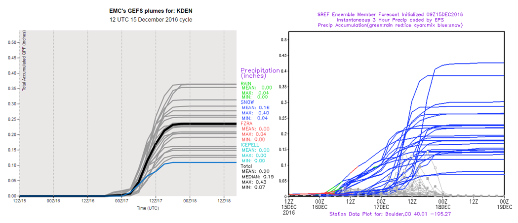
Total accumulated liquid precipitation forecast plumes from the GEFS (left) and SREF (right) models. Fairly good agreement for 0.15 to 0.30″ of liquid.
This consistency lends fairly strong confidence to how this storm will play out in general. Using snow-to-liquid ratio of 15:1 (which is reasonable for cold temperatures near 10 degrees), this equates to about 2 to 4″ of snow for the Metro Area. With upslope being such a vital component to this storm, expect higher totals for areas closer to the Foothills, including Boulder, Lakewood, and Golden, with lesser totals to the east. The Foothills will do better with totals generally ranging from 4-8″.
Highs on Saturday will struggle (and likely not succeed) to reach 10 degrees during the afternoon, with well below zero readings once again Saturday night!
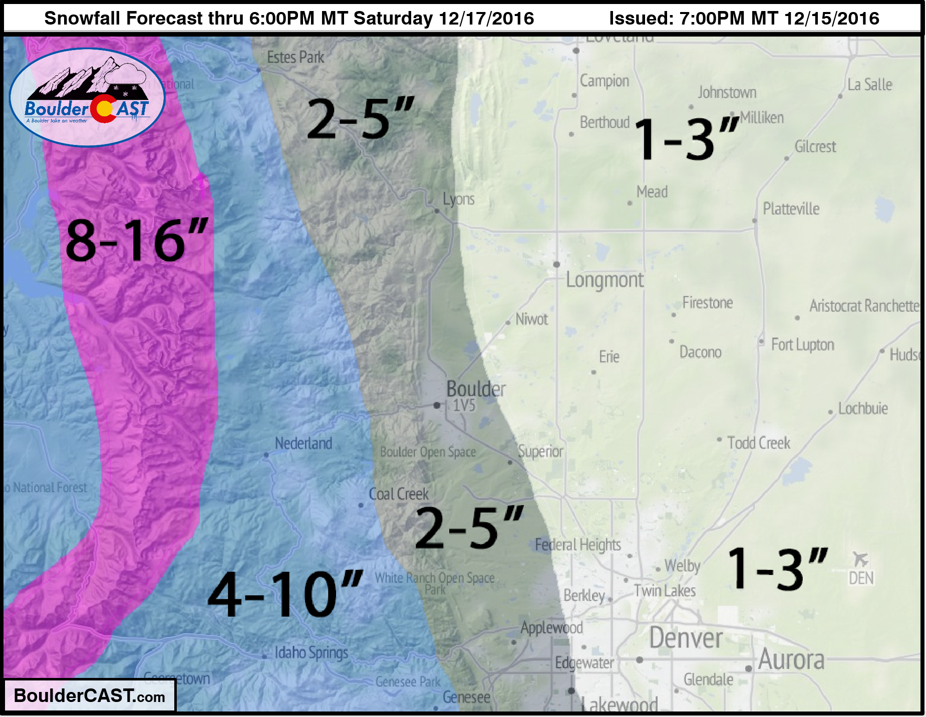
Here’s our snowfall forecast map for snow through Saturday evening:
Stay warm this weekend….it’s going to be quite the challenge!
.


