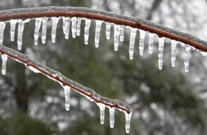
Yesterday saw a mix of wintry precipitation fall across the Denver Metro area. Snow pellets and snowflakes were observed in spots, but closer to the Foothills near Boulder, freezing drizzle produced a dangerous glaze of ice that was responsible for numerous car accidents (and probably many pedestrian slips and falls). We explain the rare weather set-up the led to the somewhat unexpected occurrence of ice in Boulder.
As mentioned in our weekly outlook, we were anticipating a cold front to move through Tuesday morning. On the backside, light upslope was to provide the potential for spotty snow showers and flurries during the day Tuesday in and near the Foothills. However, when looking outside in Boulder around 9AM yesterday and noticing fog, concern increased about the possibility of freezing drizzle replacing light snow in our forecast…definitely a problem! With temperatures in the mid 20’s at ground level, this was indeed FREEZING fog.
The Front Range Plains are nearly immune to threat of full-on freezing rain, but CAN experience freezing mist/drizzle if conditions come together perfectly. This usually happens about once or twice each winter.
Freezing rain is unattainable in Boulder.
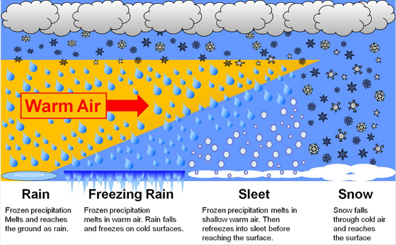
Actual freezing rain is nearly impossible in the Denver Metro area because of our proximity to the Mountains and the specific weather pattern that is required for its existence. For freezing rain to occur, there needs to be a shallow layer of cold air with warm air aloft (see image below).
Credit: National Weather Service
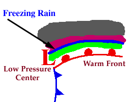
This set-up almost exclusively occurs along and just to the north of warm fronts extending from a developed surface low pressure (blue region below). The warm air is less dense and therefore “floats” on top of the retreating cold air, making the wedge shape seen above. The diagram above is actually a warm front moving from left to right.
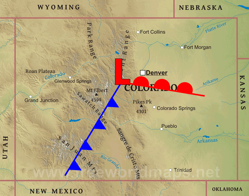
The problem for our region is that Mountains generally don’t allow intense surface lows to track across them. As you can probably imagine, giant peaks pushing into the middle of the atmosphere are not great for organized low-level airflow. You will notice with most of our winter storms, the surface low usually forms in eastern Colorado (capitalizing on lee-side frontogenesis) and intensifies as it moves eastward. It’s practically impossible for Denver to end up just north of a warm front. The surface low and associated fronts would have to be over the Mountains (see diagram below), which we just explained is unlikely.
However, as the low intensifies and gathers warm/moist air, a warm front could support freezing rain about 100-150 miles from the base of the Foothills. In fact, southeast Colorado was under the gun for some light freezing rain just ten days ago.
Freezing drizzle is doable.
As we eluded to earlier, freezing drizzle or mist is very much possible for the Front Range. Are we splitting hairs between rain and drizzle? Maybe, but drizzle is drizzle! You aren’t going to get widespread power outages or a 1/2″+ of ice accumulation from freezing drizzle. Its impacts are usually just enough to cause slightly dangerous travel on untreated roads, which is exactly what happened on Tuesday.
Below we list numerous factors that aligned yesterday to produce the freezing drizzle in and around Boulder…
- Shallow upslope: Behind yesterday’s front, shallow and weak upslope pushed up against the Foothills, creating a very shallow fog layer. The precise direction, depth, intensity, and moisture content of the upslope were all key to the weather scenario that played out.
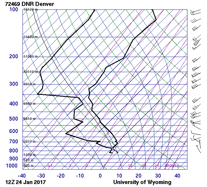
- Capping dry/warm layer aloft: The 5AM weather balloon launched from Denver International Airport shows northerly flow and a saturated layer at and below about 770 millibars, or about 7,500 feet elevation (above sea level). This sounding is not all that representative of the scenario in Boulder and was before the fog/drizzle rolled in, but the dry air and downslope aloft is visible. This capping layer prevented the upslope from expanding the fog layer upwards into a “real” cloud.
. .
. - The fog itself: Fog droplets are unique in that they can persist in a saturated environment, but don’t actually grow much in size. This is because once they get too big, gravity takes over and they fall out as mist or drizzle (if many drops collide into each other). To form rain drops, you need upward moving air to balance the pull of gravity while the droplets gather water vapor to grow into rain drops. Yesterday’s weak upslope didn’t provide enough lift to support anything more than drizzle/mist.
.
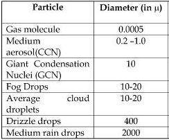 .
. - Freezing temperatures everywhere: Yesterday the morning temperature in Boulder was in the middle 20’s, well below freezing. Though we can’t know for sure, it was likely the entire atmospheric layer above Boulder was also below freezing. So why didn’t the liquid fog droplets freeze into snow before falling to the ground? A unique aspect to water is that it cannot freeze on its own (unless the temperature is near -40 degrees F). It needs something to attach onto to initiate the freezing process. In the atmosphere, water droplets can begin freezing to form snow due to tiny particles of junk in the air called ice nuclei. In a normal cold cloud with snow involved, droplets are large enough that there is a high probability that many of the droplets contain an ice nuclei to initiate the freezing process, and elevated clouds are often colder than fog layers (this is important because the concentration of ice nuclei increases with decreasing temperature). However, fog droplets are so small (on the order of just 10 microns) that the odds of any droplets actually containing ice nuclei is incredibly low, especially with temperatures in the mid to upper 20’s. Therefore, though the air was cold enough to form snow, the nature of fog itself prevents this, especially given yesterday’s temperature structure.
So there you have it! The upslope had to be just the correct depth and intensity. There needed to be a capping downslope layer just above the surface. The moisture needed to be there to support the fog. Temperatures had to be in the mid to upper 20’s to prevent too many fog droplets from freezing, which would have led to tiny snow balls instead. Everything came together just right yesterday for a unique weather event that only occurs once or twice every year for the region.
The National Weather Service did put out a Freezing Fog Advisory at some point Tuesday morning, but roads in Boulder were already beginning to ice over by then. We think the city did a fine job of being REACTIVE to the storm when weather forecasters (including us) prevented them from being PROACTIVE.


any salty veterans remember the good friday ice “storm” in 2007? i dont believe it was a freezing rain(?) but just a thicker glaze from a freezing fog incident but it’s the last time i remember boulder getting frosted like this.
A brief glance through Boulder’s weather record does have any obvious “that was a freezing mist day!”. I tried to find any record of ice in Boulder and Denver and couldn’t. Though I am sure something did happen pre-internet, maybe once or twice.
i was in RMNP that day and have some great photos of everything covered in a heavy frost. driving back into town everything was a skating rink with accidents on _every_ over pass. Wish i’d taken some pics of the trees and grass to show the glaze.