A mix bag of wintry weather will be present across the Metro area through Saturday evening. Read on as we discuss how things will play out and provide our snowfall forecast for Saturday.
The cold air has arrived…
We’ve been discussing model differences with our Premium members through the week, with each model handling this morning’s cold front differently. The clear winner ended up being the European model, with the shallow Arctic front arriving before sunrise this morning. The temperature and dewpoint graph from BoulderCAST Station shows the front arriving around 4:00 AM, with temperatures quickly falling into the 20’s thereafter.
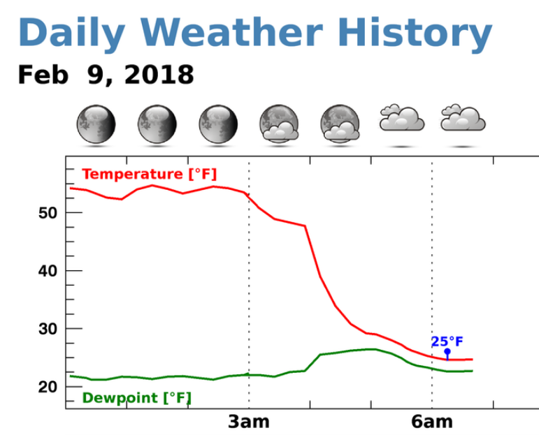
Temperature and dewpoint from BoulderCAST Station this morning showing the front’s arrival around 4:00AM Friday.
Dense freezing fog is now widespread across the lower elevations, with also a few reports of isolated light freezing mist and a few snow flurries. The travel impacts Friday morning will be minimal as the freezing fog looks more ominous than it actually is.
What happens the rest of Friday?
Models still don’t agree on an answer to this question, even just a few hours from now. It’s been quite some time since I have seen the models consistently handle temperature so poorly. The struggle is due to the shallowness of the cold air in general, and exactly how it “mingles” with the warm and windy layer that now resides just above. The skew-T diagram below from this morning’s balloon launch in Denver shows the cold layer at the surface only extends up a few hundred meters from ground level. This was at 5:00 AM, and the cold layer has deepened a tad (up to around 7,000 feet elevation).
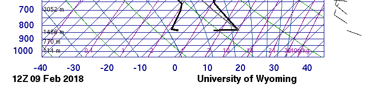
Sounding from the balloon launch in Denver at 5:00 AM Friday. Note the shallow cold air and steep inversion just above the surface (right black line).
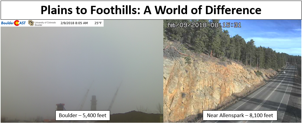
Skies are sunny with temperatures starting to warm through the 40’s above 7,000 feet. So we know the Arctic airmass is at least confined below that. The webcams this morning show the world of difference a few thousand feet elevation can make. One particular location west of Boulder at 7,100 feet is right on the fringe of the cold air. It’s been a wild ride of temperatures so far this morning!
In the latest run, the GFS model is pretty much ignoring its own initial conditions, pretending there is no Arctic air at all and then taking temperatures into the upper 50’s this afternoon. The NAM is slightly better, but still warms us into the lower 50’s. The HRRR model recognizes the frigid air at least, but has the northwest flow aloft quickly eroding the Arctic airmass by early afternoon. Naturally it shows temperatures getting close to 60 degrees. The animation below shows the epic battle between the warm and cold air masses over the Denver Metro area through the day.
HRRR model temperature forecast showing unrealistic warming this afternoon to near 60 degrees.
This warm-up is almost impossible at this point. If you recall, there was a very similar scenario this past Sunday. The shallow cold airmass held strong and temperatures did not make it out of the 20’s in Boulder and Denver. We expect something along the same lines to occur today.
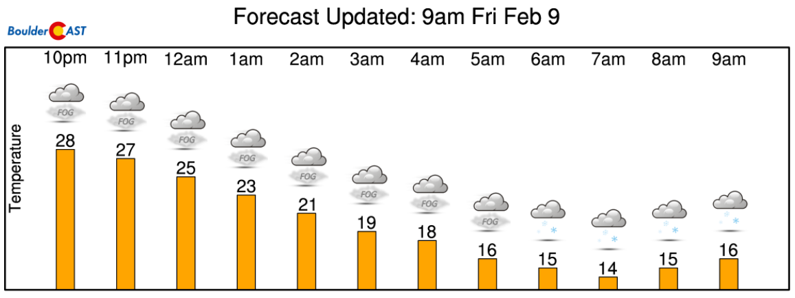
Unbelievably, as we have seen, several models show temperatures getting close to 60 degrees. On the opposite end of the spectrum, if the upslope and moisture stay persistent through the day, temperatures could remain in the 20’s. A near 40-degree forecast uncertainty! It’s definitely a challenging one to the say the least. We’re going to lean towards to the colder end with temperatures topping out between 30 and 40 degrees this afternoon. The fog should clear by early afternoon and amount to minimal impacts outside of a few flurries and gnarly-looking trees.
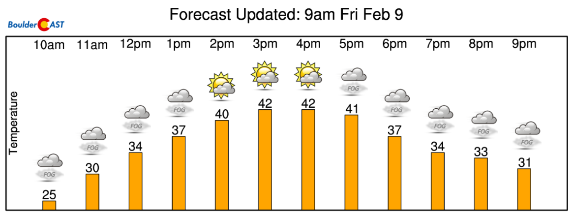
Our expectation is that the freezing fog will lift by early afternoon with temperatures warming into the 30’s.
Light snow develops Saturday morning
Towards the tail-end of the HRRR animation above, you will notice a more substantial push of cold air. All of the models are showing this happening around or slightly after sunset this evening. This secondary push will usher in more moisture and even colder temperatures….teens and single digits…to northeast Colorado. After this front, there will again be spotty freezing drizzle and fog possible across the region overnight and maybe a few flurries as well. The moisture content is not great, however, so only patchy and minor ice accumulations are expected. Still, be cautious when traveling early Saturday.
It’s not until Saturday MORNING that the large-scale lift and colder air aloft from the trough arrives. This is the time-frame when we expect any wintry mix to end and snowfall to increase in coverage and intensity.
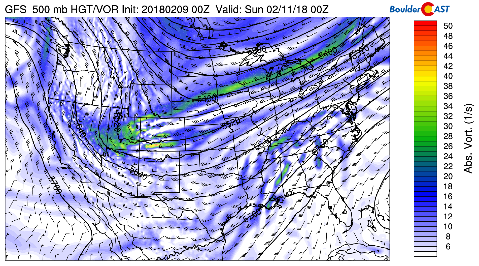
GFS 500 mb vorticity map for Saturday showing the weak trough moving across Colorado and Utah.
The forecast soundings for tonight show the evolution from freezing mist/drizzle profile to a snow profile by morning. Notice the cooling and slow saturation of the air aloft. This will allow for more mixing and form a deeper cloud layer, spreading light to moderate snowfall across the Metro area.
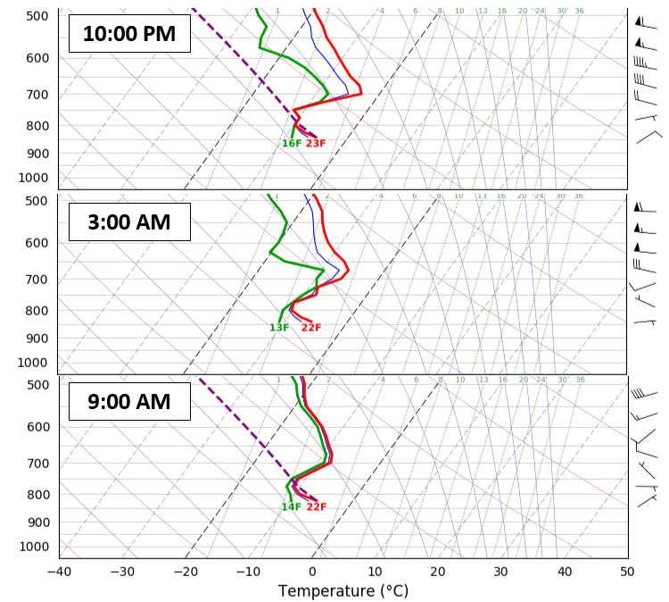
NAM model sounds for the north Metro area Friday night into Saturday morning. The profile evolves from freezing drizzle to snow.
There is about a 12 to 16 hour window for snowfall across the Plains and Foothills, beginning after sunrise on Saturday lingering into the evening hours. The heaviest snow will likely fall Saturday late morning and afternoon, with snowfall rates at times approaching 3/4″ per hour. This will be the result of efficient easterly low-level winds (upslope) and minor lift enhancement from the overhead jet stream.
After a night of freezing fog and mist, snow is expected to commence around sunrise Saturday morning or slightly after.
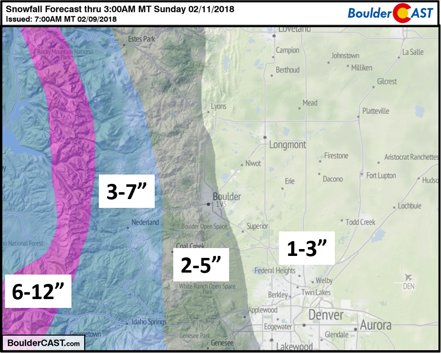
Models generally agree in 1 to 4″ of snow for the Plains, with 3 to 8″ in the Foothills. As normal, the western Metro area will do better than the east from these type of storms. The upslope is expected to generally remain below 750 mb, so we shouldn’t see MAJOR enhancement in the Foothills, but there will be some.
Our snowfall forecast map is below…
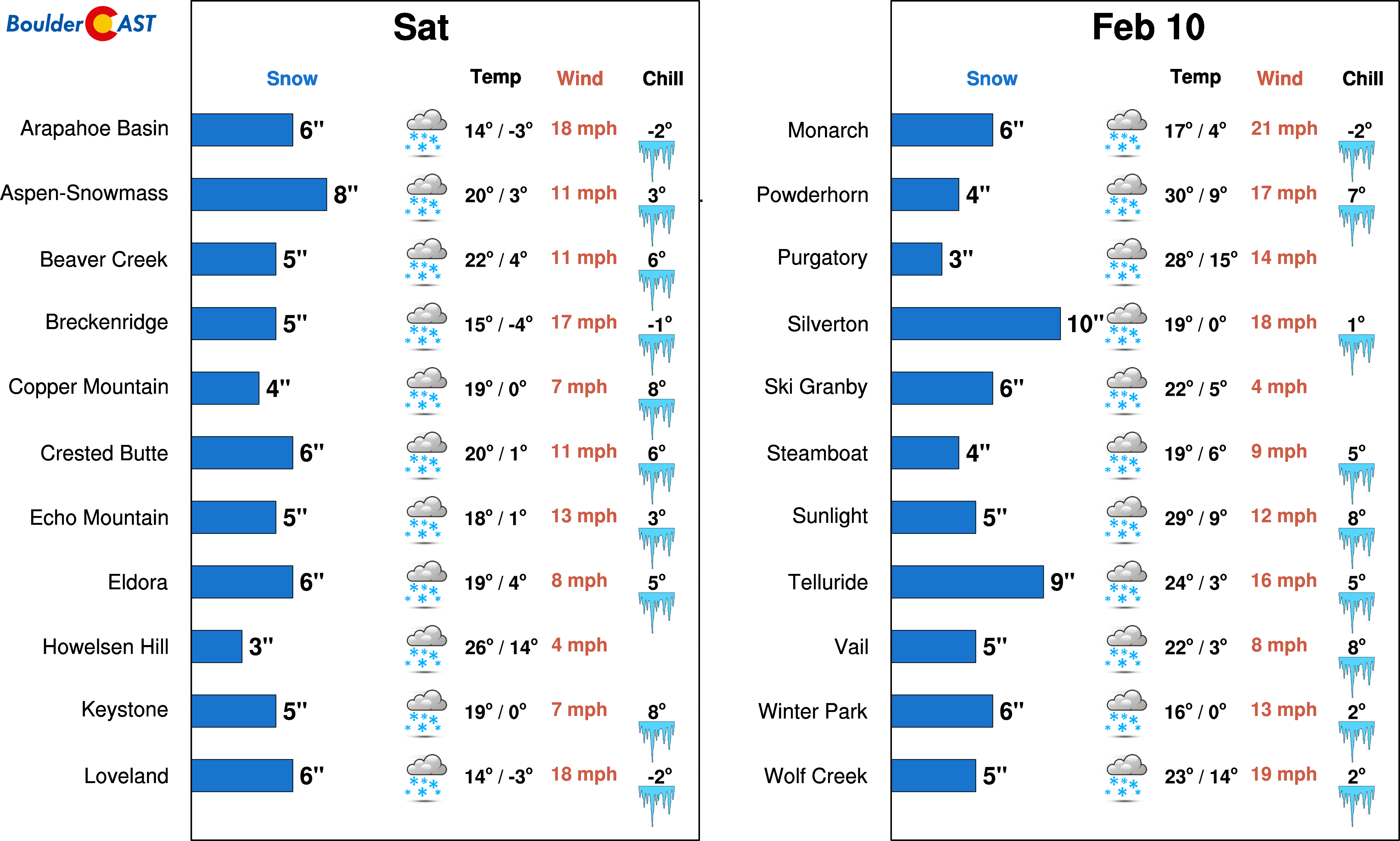
For the skiers, Mother Nature will be delivering 4 to 10″ of accumulation. For the forecast specifics, head over to PowderCAST.
The second half of the weekend will be much better than the first…we promise! Sunshine will take over across the state on Sunday with much warmer temperatures. Models are showing mid 40’s, but we’ll hedge a little colder given the fresh snow on the ground. Highs should top out near 40 degrees.
Enjoy yet another taste weekend winter! They are great for skiers and fireside chats, but not-so-much office-closing snow days….
.
Share our forecast:


