Warm weather has been the story over the last few days for the Front Range, but that headline is about to change with the arrival of a potent winter storm Saturday night. We explain the atmospheric set-up and detail what will likely be our biggest snow event so far this winter across the lower elevations.
Keep in mind that Denver has seen near-record low snowfall thus far through January 19th, only 6.5″. Any snow is significant at this point!
The Pacific trough responsible for this snowy forecast update is coming ashore this evening. We’ve been closely tracking it for the last five to seven days in the models, first alerting you to it on Monday morning. After those snowflakes on MLK Jr Day, temperatures jumped up several degrees each day this week, peaking in the 60’s yesterday and today. Much of the warmth the last few days was due to the southwesterly downslope flow ahead of this trough.
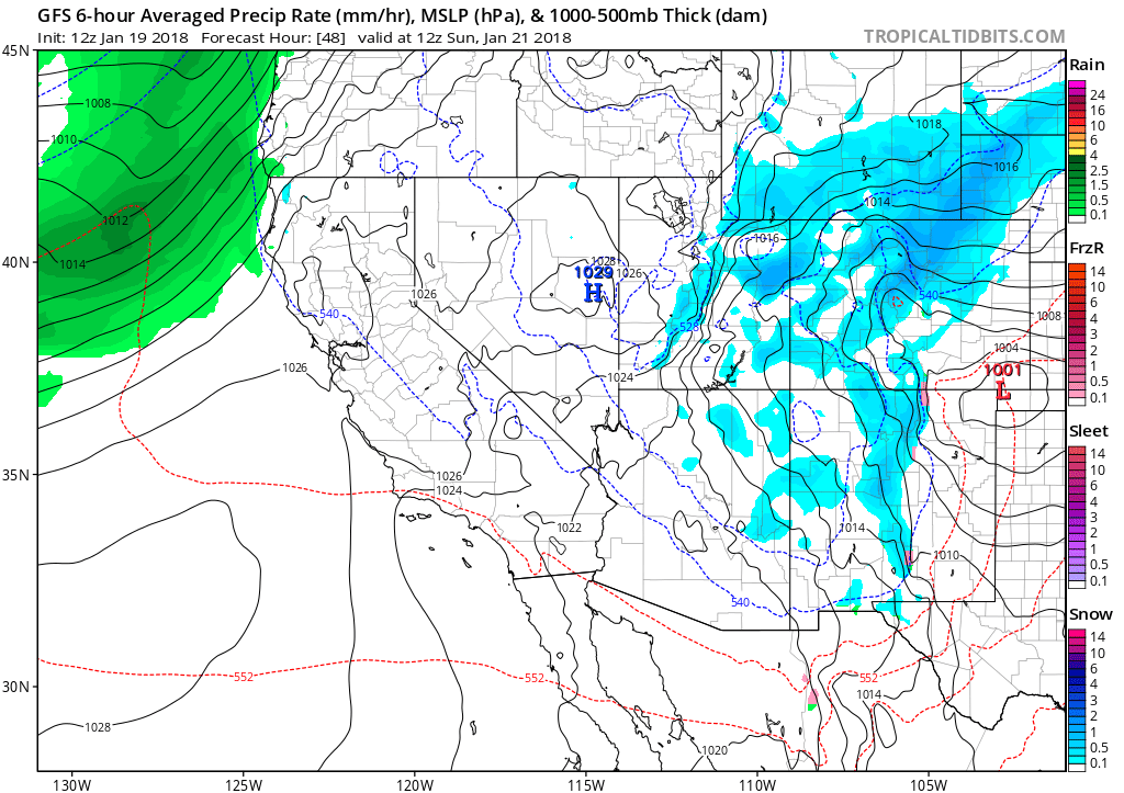
We’ve discussed with our Premium members this week that these type of large-scale systems are often handled well by the models, and consequentially are relatively well-forecast for many days leading up to the storm’s arrival. The timing and intensity of this weekend’s storm hasn’t wavered too much this week. The GFS model was initially running about twelve hours too early (see the animation below), but the Euro model has been near-perfect since Monday.
GFS forecast trend animation for 5AM Sunday morning. This animation covers GFS model runs from January 14 to 19. Notice the westward shift in the storm (slowing) and overall better snowfall dynamics across northern Colorado.
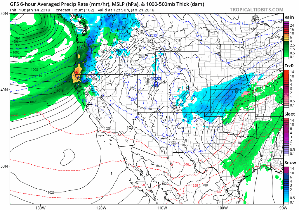
What gets us most excited for this snow storm? It’s a true, cut-off Four Corners’ low that will track across the Colorado/New Mexico border on Sunday. This will put northern Colorado and Denver in the bulls-eye for large-scale lift and at least some upslope. The position of the upper-low at midnight Saturday night is shown below.
GFS 500 mb vorticity map for Saturday night. The upper-low will move across the Four Corners’.
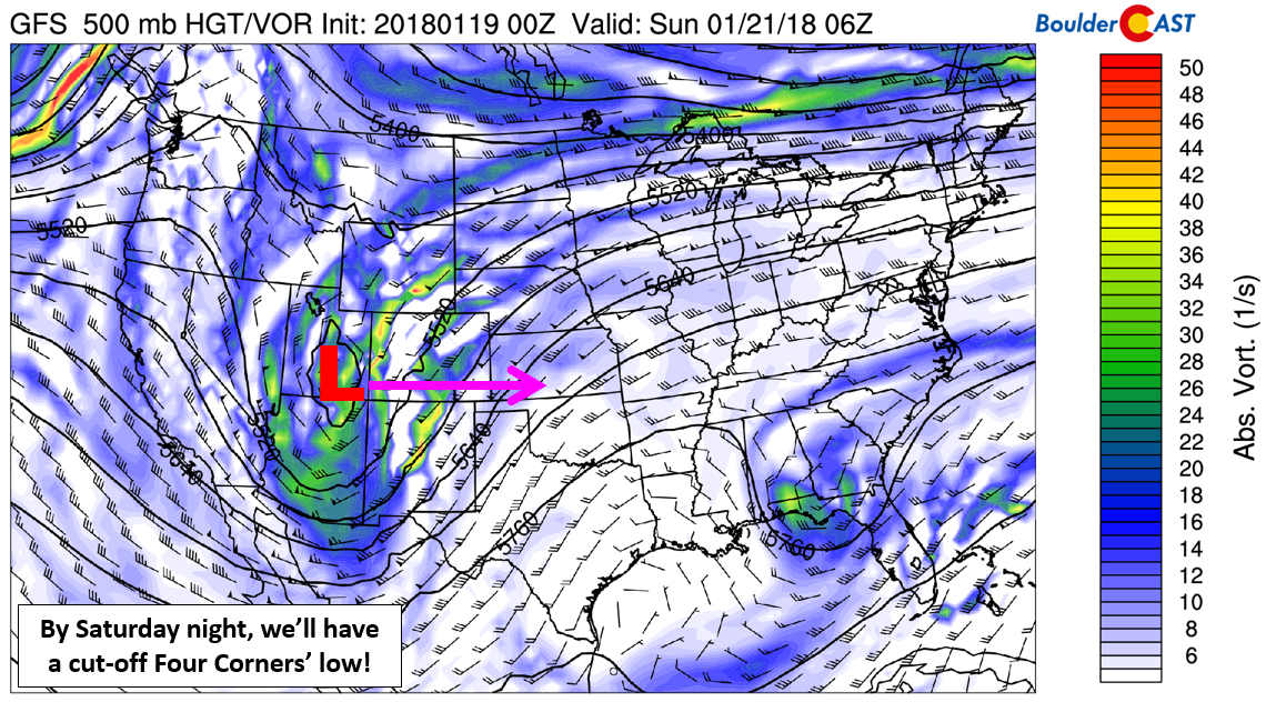
As the upper-low approaches, lee cyclogenesis will begin Saturday evening across eastern Colorado, with a surface-low forming and strengthening east of Trinidad, CO (shown below). The pressure falls from this low will help to rapidly swing a cold front through the Denver Metro area Saturday night.
GFS precipitation and sea-level pressure map for Sunday morning. Note the surface low in southeast Colorado and heavy snow across the Front Range.
While the track of the storm is promising, it’s the middle of January and the background atmosphere is about as dry as it gets this time of year, far from the juicy-levels we see during our biggest snow storms in March and April. Moisture availability has been a lingering concern for us all week, and though the models seem to be suggesting it will indeed be there at this point, we are cautious about this. If moisture is lacking, other aspects of the storm need to make up for it. We’re not so sure that will be the case here…
Another concerning facet of this storm, for Boulder and the Foothills at least, are the northerly low-level winds throughout the event. After sunrise on Sunday, winds turn almost due northerly (little to no upslope component). For this reason, we don’t expect Boulder to trump the rest of the Denver Metro area as is usually the case for most snow storms. We should see snow totals more evenly distributed across the Front Range this weekend, with the highest totals likely on the south side of Denver where northerly winds will be upslope for the Palmer Divide.
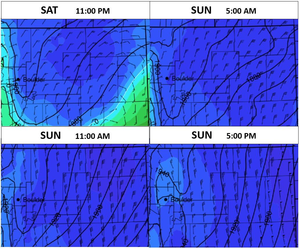
NAM 800 mb wind fields for the duration of the storm. After the initial surge of northeasterly upslope, winds back to northerly as early as Sunday mid-morning Sunday.
TIMING:
Following near-record warmth on Friday (70 degrees in Boulder, can you believe it!?), temperatures Saturday will be cooler, but still above normal. Upper 40’s to low 50’s seems probable, especially around mid-day. Models have a roughly six-hour variation on the timing of the cold front, but it shouldn’t really impact things too much. We’re thinking that the cold air will hit Boulder and Denver after 8:00 PM Saturday evening, with temperatures falling below freezing by midnight. Precipitation will also commence around this time….therefore, it’s going to be a mostly snow event, potentially after a brief 1 to 2 hour period of light rain or freezing drizzle as the front passes.
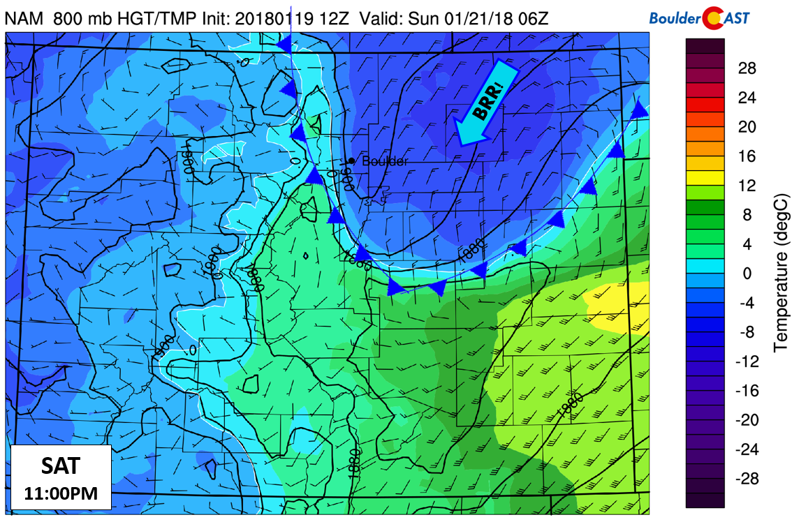
NAM 800 mb temperature and wind forecast for 11:00 PM Saturday evening. We really didn’t have to highlight the location of the cold front….
Snow will continue through the night and into Sunday afternoon for the region. The heaviest of it will fall in a window from 2:00 AM to 10:00 AM, with snowfall rates potentially reaching 1″ per hour. This is the time-frame with the most favorable upslope and there may also be a few jet-forced snow bands across the Metro area (oriented southwest to northeast). Travel will be tricky during the morning hours on Sunday, but should improve by afternoon and evening as the storm system pulls eastward into Kansas. Temperatures Sunday will remain in the 20’s.
SNOWFALL AMOUNTS:
We’re still more than 24 hours out from any snowflakes, but potential snowfall amounts are coming into focus. There is good model agreement for 0.3 to 0.5″ of liquid across the Metro area. The GEFS ensemble median and mean are around 0.4″ in Boulder (see below), and not much different in Denver.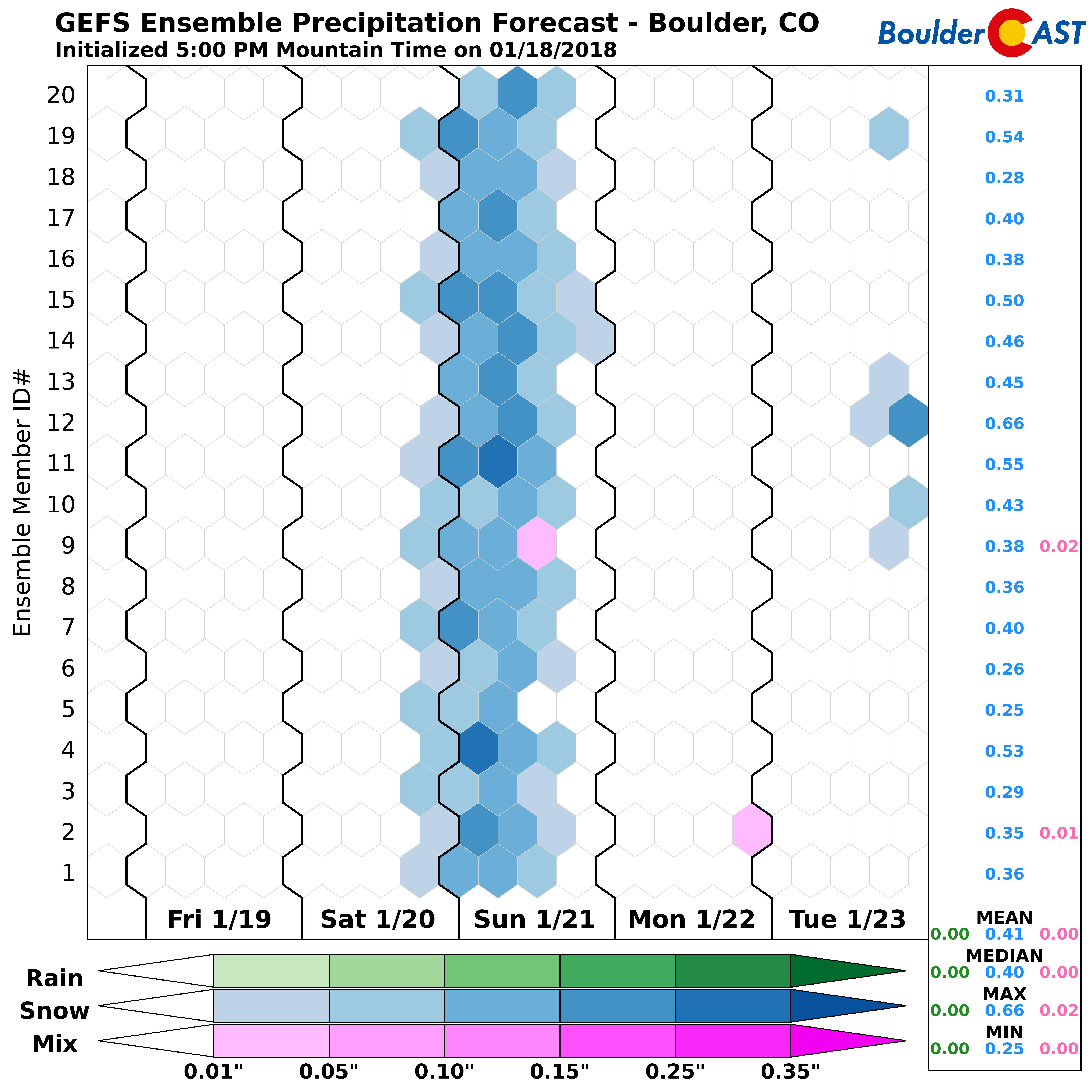
We’re expecting snow ratios for this event across the Plains to be 13:1 to 15:1. Given this, snow totals should end-up the largest so far this winter in many locations from this storm. We’ll have our official snowfall map out Saturday morning, but until then, here is what we are thinking:
- Denver Metro area – 3 to 8″ : The highest totals will be in the southern parts of the Metro Area where northerly winds mean upslope. We’ll fine tune area specifics in our map tomorrow.
- Foothills -4 to 10″ : Upslope is not a major player from this storm, so the Foothills won’t do THAT much better than the lowlanders. Still, fluffier snow ratios up there should allow for a few higher totals near 10″.
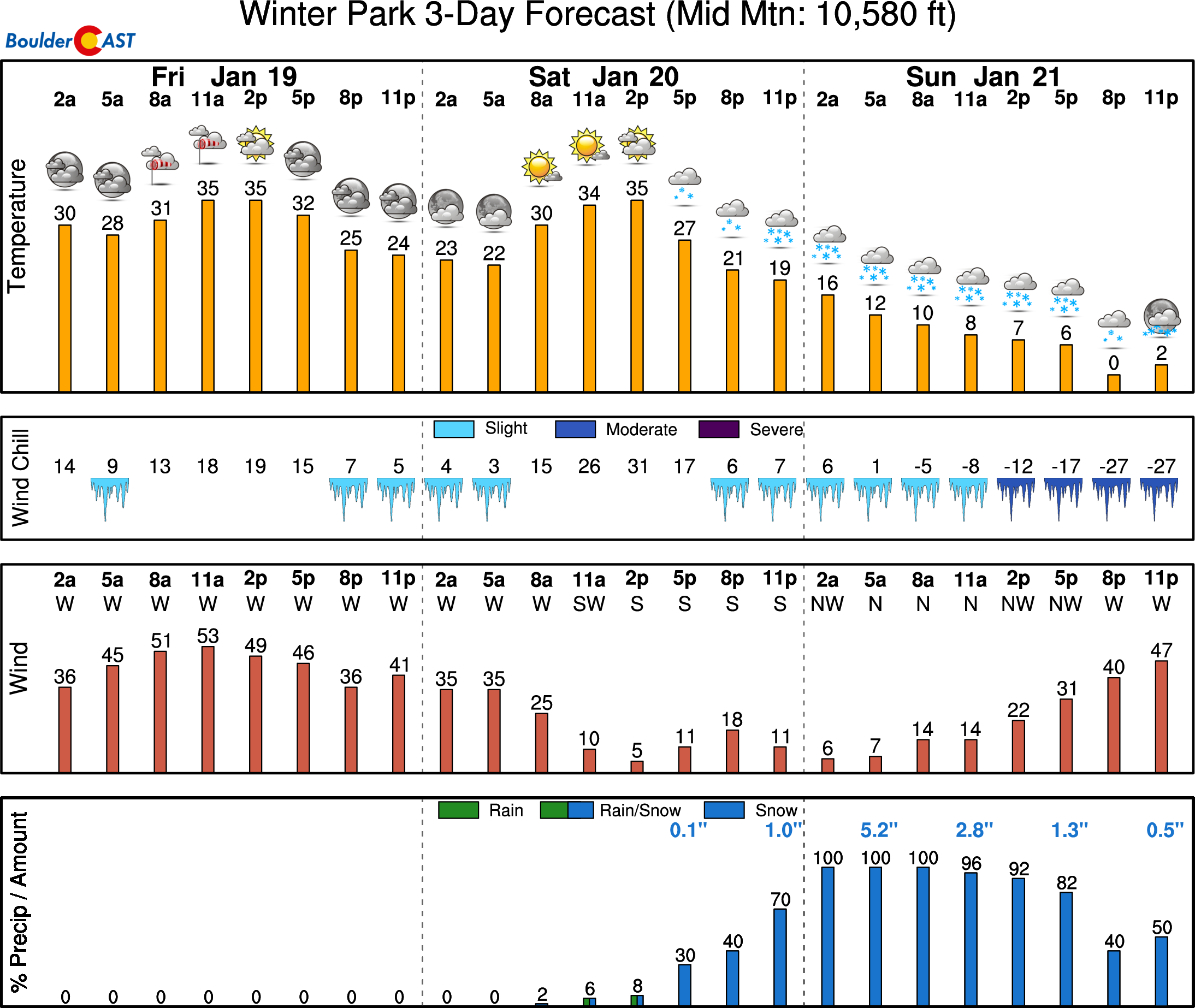
- Mountains above 10,000 feet near and west of the Divide – 8 to 15″: This includes all of the ski resorts! Sunday will be a powder day for all! Winter Park anyone?
To conclude….
Overall, not a monumental storm by Front Range Colorado standards. We’ve definitely seen worse! However, many folks haven’t seen all that much snow yet this winter. This storm could definitely be a bit of winter wake-up call. Check back Saturday for our final forecast and detailed snow map. That’s all for now. Go forth…get your milk and bread!
Share this forecast!


