Don’t be fooled by the warm temperatures Wednesday afternoon! A rapid transition back to winter-like conditions will begin Wednesday evening capped off with another round of light snow following on Thursday. In this forecast update, we discuss the BIG changes that will bring the coldest airmass since mid-February into the Denver Metro area and the expected snowfall amounts for the region.
PREMIUM STORM UPDATE (8:00 AM Thu 04/02/20): We do a quick check on how the overall forecast looks this morning as freezing drizzle falls across the area and bitter cold temperatures settled into the Front Range. Click HERE to read.
Key Forecast Highlights:
- After highs near 70 degrees on Wednesday, temperatures take a nose-dive for Thursday
- Two strong cold fronts will blow through the Front Range ushering in a bitter cold Arctic airmass for the second half of Thursday
- Pockets of moderate to heavy snow will be possible Thursday late afternoon into the evening
- Up to 4″ of snow accumulation, mainly north and west of Broomfield, less elsewhere
W
e’ve had a few big dumpings this winter, but Thursday’s upcoming snow event will be the 15th one in which Boulder receives less than 6″ of snow. The frequency of little snowfall events has been higher than normal this winter, a pattern more typical during a La Niña, which this year is not…there’s actually a borderline weak El Niño now!
The Northern Rockies remain in a favorable weather pattern for another round of light snow to impact our area Thursday afternoon into Thursday night. This system comes complete with a surge of very cold air which will translate into snow levels plummeting quickly to encompass the entire Denver Metro area with everyone poised to see a little bit of snow in the next 36 hours. The incoming storm is gaining momentum in the Pacific Northwest as of Wednesday afternoon (see below). It will rotate eastward and across northern Colorado by Thursday evening.
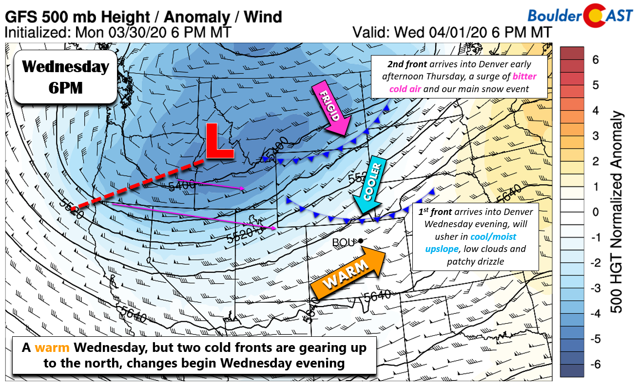
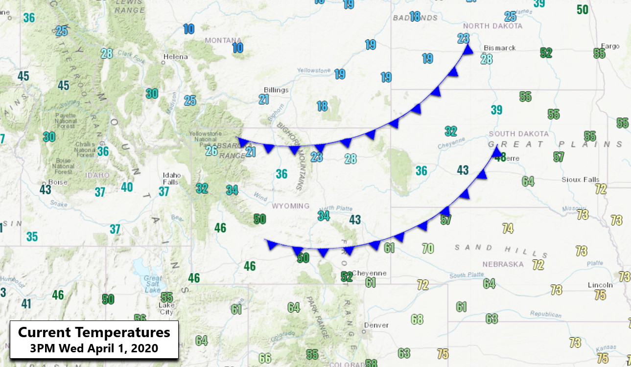
The first of two cold fronts is currently located north of the Wyoming border and it will push through the Denver Metro area around sunset Wednesday evening. The position of the front is annotated onto current surface observations below. Notice the modest temperature difference between Denver and Cheyenne right now.
The secondary Arctic front is the one we are watching for our chance of snow on Thursday. It is trailing the initial front by about 350 miles and is currently forecast to plow into Boulder and Denver around mid-day Thursday. Notice just how cold the Arctic air behind this secondary front is: temperatures are only in the single digits and teens on the backside in northern Wyoming and Montana! A timeline of both frontal passages from the GFS model is shown below.
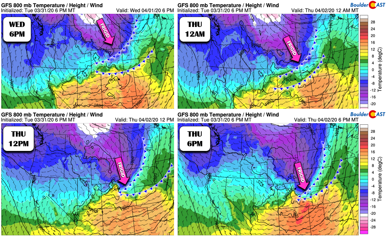
The surge of bitter cold air from the north and west with this second front will produce strong frontal lift as it blows through the Front Range Thursday afternoon and evening. This will be the main forcing mechanism for snow across our region this time around. Everything will however be enhanced slightly by weak and shallow upslope along with minor large-scale ascent from the passing trough.
Temperatures will remain steady in the 30’s on Thursday or even fall through the afternoon as the coldest of the air filters in. The north-south temperature gradient across eastern Colorado will be impressive…nearly a 50-degree temperature drop from the New Mexico to Wyoming Borders.

By mid to late afternoon, strong instability along the front will lead to pockets of moderate to heavy snowfall while temperatures sit in the upper 20’s to lower 30’s across the Plains and in the lower 20’s in the Foothills. The overall track of the energy and frontal lift favors the northern and western portions of the Metro area. This trend is clear in nearly every weather model across the board so our confidence is high on this facet. The HRRR model simulated radar below shows a potential snow band location by early evening Thursday. With gusty winds occurring at the same time, this is the exact type of scenario where we could see a few Snow Squall Warnings issued for the northern Metro area due to near-zero visibilities.

Timeline:
- Most of Wednesday will be warm but cloudy with highs in the upper 60’s to near 70 degrees. Get out there and enjoy it!
- Cold front #1 passes through around sunset Wednesday evening with temperatures cooling into the 40’s and 30’s. Eventually low clouds and drizzle will form late Wednesday night into Thursday morning. It may be just cold enough for this to be freezing drizzle in most areas.
- Thursday will be gloomy, but generally dry (outside of the morning drizzle) until the main snow event takes shape later in the day. Expect temperatures to hold in the 30’s through the day with a few sprinkles or flurries possible.
- By late Thursday afternoon and early evening, snow will begin to spread from northwest to southeast across the area just behind cold front #2. Snowfall could be heavy at times, including embedded squalls of near-zero visibility. The heaviest and most widespread snow will occur between 3PM and 9PM.
- Light snow will linger due to the shallow easterly upslope continuing, especially along the base of the Foothills, late into the overnight hours. Low temperatures fall into the single digits in the Foothills and into the upper teens on the Plains by sunrise Friday. This will be within a few degrees of record lows for the date in many cities!
- High temperatures on Friday will struggle to reach 40 degrees and probably don’t in most areas. Foothills locations stay in the 20’s.
Snow Amounts:
As mentioned, models are clearly targeting the northwestern Metro area and northern Foothills with this system, which makes sense given the track of the parent storm across far northern Colorado. Forecasted precipitation amounts are listed below from a handful of weather models. Outside of the NAM, we have solid agreement all-around.
- GFS: <0.1″ Denver / 0.3″ Boulder
- GEFS Ensembles: 0.15″ Denver / 0.2″ Boulder
- NAM-NEST: 0.1″ Denver / 0.35″ Boulder
- NAM: Trace in Denver, <0.1″ Boulder
- Euro: 0.1″ Denver / 0.3″ Boulder
- HRRR: 0.1″ Denver / 0.3″ Boulder
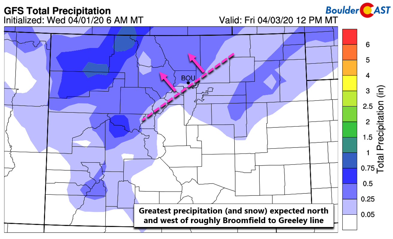
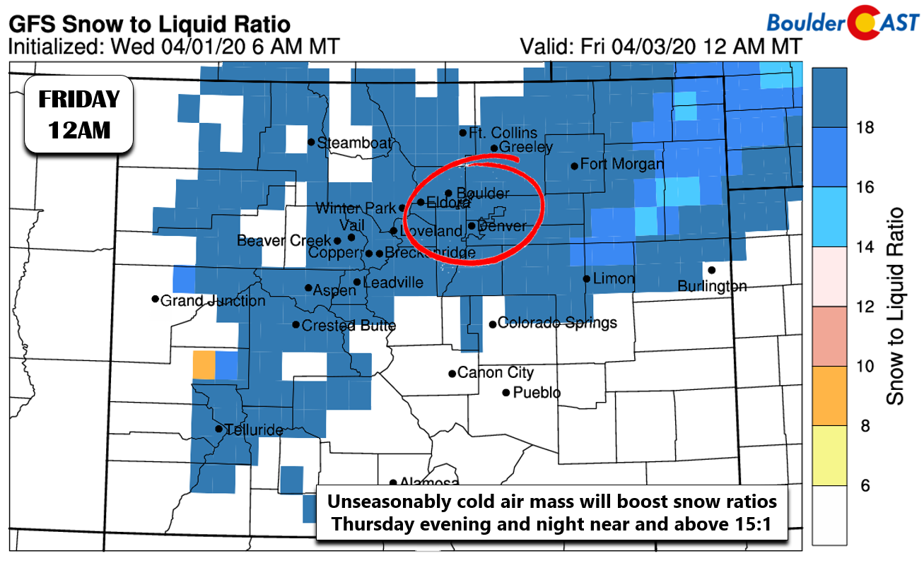
Obviously, precipitation amounts are expected to be fairly light. Some of that liquid will be lost to brief rain or melting near the onset. However, very cold air filters into the Front Range by early evening which will allow snow to accumulate better as the sun lowers in the sky as well. Additionally, snow ratios will increase as time goes on. Anything that falls after 6:00 PM or so will be fluffy.
Our thoughts on amounts are reflected in our snowfall forecast map for the event shown below. This covers snow falling through Friday morning.

…and here are the latest odds of various amounts from our Snowfall Probability Charts.

The timing of the snow will coincide with the evening commute, especially around Boulder (whatever is left of rush hour during the pandemic lock-down, that is). Watch out for brief whiteouts during this time. Overall impacts from this storm will be limited by the light snowfall amounts, warm road temperatures, and the short window for accumulation. Don’t be caught off guard by those chilling temperatures Thursday into Thursday night, though. They are quite the change from where we are right now…

Front Range current temperature analysis as of 3:00 PM Wednesday
Help support our team of Front Range forecasters by joining BoulderCAST Premium. We talk Boulder and Denver weather every single day. Sign up now to get access to our daily forecast discussions each morning, complete six-day skiing and hiking forecasts powered by machine learning, first-class access to all our Colorado-centric high-resolution weather graphics, bonus storm updates and much more! Or not, we just appreciate your readership!

.
Spread the word, share the BoulderCAST snow forecast!


You must be logged in to post a comment.