Another spring storm is taking aim at Colorado, the fourth one in less than two weeks! The last few storm systems were a bust for the Plains, with more rain than snow. This storm, however, is colder in all the right ways and is likely to bring snowfall for most. How much snow is expected for the region, including the ski resorts and Foothills? Will this be another classic case of “The Weatherman That Cried Snow”? Read on for our complete forecast.
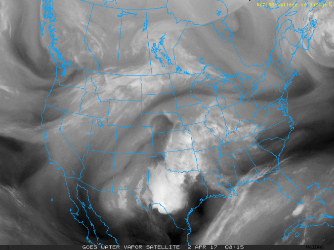
This week’s spring storm will be following a very similar storm track compared to Friday’s system. Below shows the current state of the atmosphere with an area of low pressure over southern Nevada, and west-southwest flow to the east of the system over Utah and Colorado.
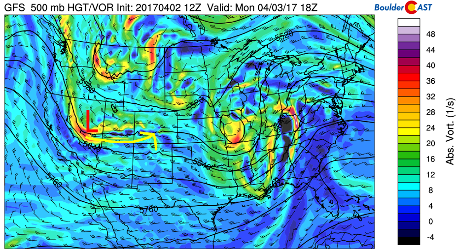
GFS 500 mb vorticity map for today
This low pressure system will be tracking southeast into northern New Mexico by tomorrow morning (see below figure), and eventually into the Midwest by Wednesday. It’s this storm that will lead to the threat of snowfall across the mountains, Foothills, and Plains tonight and tomorrow. Join us as we discuss the most influential factors for this storm and its differences from the last one below.
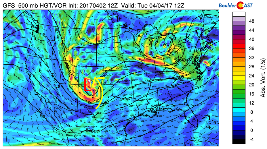
GFS 500 mb vorticity map for Tuesday morning
The four ingredients we want to discuss for this storm are:
- Moisture
- Lift
- Upslope flow
- Temperatures
First, the moisture present in this storm is roughly average for this time of year. The figure below indicates the % of normal precipitable water for overnight tonight. It shows a broad region of 100-125% of normal moisture across the state, with 125-150% of normal in far southeast Colorado. The moisture is thus supportive of precipitation once again.
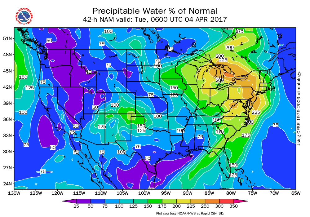
NAM model percent of normal precipitable water for overnight tonight
Second, the lift. As shown earlier, a low pressure system will be tracking just to our south again. Although the heaviest axis of lift from the low pressure will be over southern Colorado, upper-level jet dynamics may be present which will help allow precipitation to reach into northern parts of the state. Below shows the upper-level jet for midnight tonight. This jet is positioned such that the left exit is to the southeast of Denver. That puts our region in a location of upper-level divergence, supportive of lift in the middle atmosphere (area circled in red). This may help to allow some weak precipitation bands to occur near the Foothills.
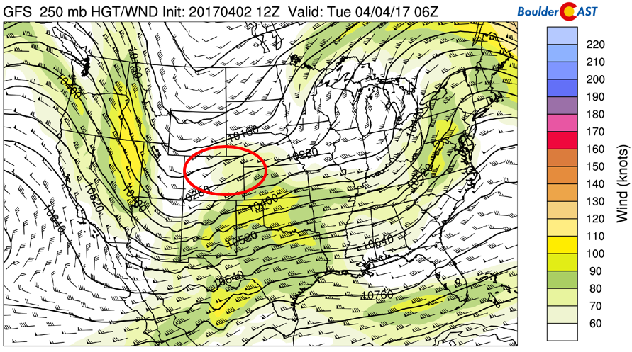
GFS Jet Stream pattern tonight
Third, let’s discuss the upslope. As with the last storm, the upslope flow will not be very strong. Below shows a time/height plot of wind, temperature, and relative humidity (shaded). Focusing on the area highlighted in red, the upslope flow for the event will extend up to approximately 600 mb, or 13,000 feet above the surface. The wind direction will be roughly east-northeast. Despite not being that strong, it should be enough lift to produce meaningful precipitation.
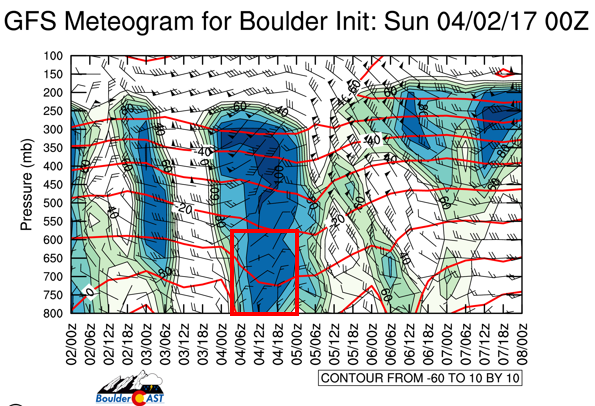
GFS time/height plot for the storm
Finally, the most key, are temperatures. As with the last two storms, snow was forecasted to happen after an initial start of rain. The snow never did occur (in most Plains locations), partly due to the track of the storm, and more importantly, the warm airmass. This storm is quite similar to Friday’s event, albeit somewhat colder. Below shows the forecasted snow levels between 6PM and midnight tonight. At 6PM, snow levels are at around 7,500 feet to 9,000 feet in the Denver Metro. By midnight, a cold front has passed through and snow levels drop dramatically below 5,000 feet. It’s likely that we’ll see a brief onset of rain, followed by a change to snow. This airmass is a little colder at the surface than Friday (not by much). However, the key is much colder air aloft. Temperatures about 10,000 feet up are forecasted to be between -10 and -12 degC, as much as 6 degrees Celsius colder than this past Friday. This will facilitate more higher elevation snow formation which will feed into the lower elevations too (seeder-feeder!). Although we are skeptical again of the models, we think this storm has high odds of finally giving everyone snow!
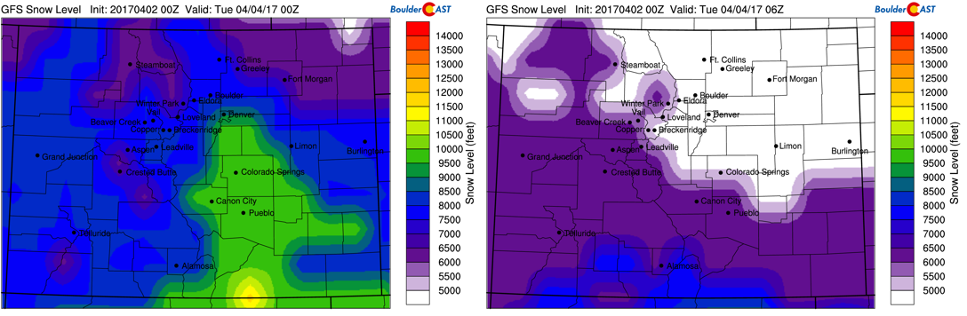
GFS model forecasted snow levels at 6pm (left) and midnight (right)
And… the precipitation forecasts… For last week’s system, there was considerable disagreement in terms of the track of the storm, as well as total accumulation amounts. The GFS had over 1″ of liquid precipitation in its forecast 2-3 days out. That never came to fruition. Furthermore, the regional and global models were showing a relatively quick change over to snow from rain. The snow never really changed over until well after midnight, a time when the the greatest lift was well south of the region. The lack of cold air aloft also limited snow formation and kept many areas drizzly.
Below shows the forecasted precipitation (left) and snowfall from the NAM (right) by Tuesday evening. The GFS depicts anywhere from 0.5 to 0.75″ of precipitation across Boulder and Denver, with up to 1″ in the mountains and Foothills. We see the favoritism for southern Colorado with a solid bulls-eye around Pueblo. Closer to home, the forecasted snowfall from the NAM is around 2-5″ on the Plains, and 6-10″ in the High Country.
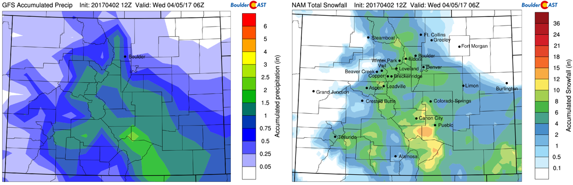
Forecasted precipitation (left) and snowfall (right) ending Tuesday evening
Ensemble plume forecasts for Denver also show a similar amount of snowfall than the NAM across the Denver metro (below), with ~ 4″ predicted.
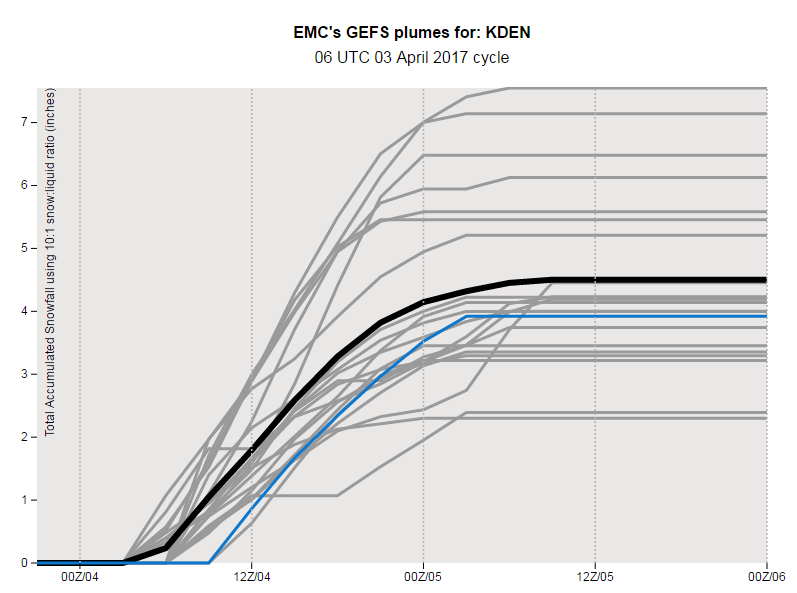
GEFS plume forecasts of snowfall for Denver
So yeah, the GFS model is on the high end again, but the separation from the rest of the models is not as great as last time. For this reason, we have elevated confidence in the forecast overall.
Final thoughts (7 of them…we’re big thinkers, apparently):
- With the past two storm events being mostly rain, we’re just as skeptical as you are for this event…particularly because the air mass is similar to Friday’s, albeit a good bit colder aloft (this is key).
- Lift is not impressive but it is decent for a light snow event across the region. The prime time for precipitation will be from midnight tonight until noon on Tuesday, coincident with the upper-level jet, low pressure system, and upslope flow.
- Moisture is slightly above average for early April…. 100-125% of normal.
- Temperatures will drop from the mid 50’s today to the lower 30’s by midnight and eventually some upper 20’s in some locations by sunrise.
- Models are in better agreement with this storm than last week’s event. The models show a more consistent track the past day or two, with ensemble forecasts also in line with approximately 2 to 4″ of snow predicted, with a range of 3-8″ for the Foothills. It also helps that this is NOT a cut-off system, but instead just an open wave. Models are much more reliable when the storm stays “attached” to the jet stream.
- Ground temps will again be a hindrance to snow amounts. However, contrary to last week’s storm, rainfall will not be as long of a duration. This will allow a more favorable snow accumulation this time around. The lift and cold air SHOULD overlap more favorably tonight.
- Models are showing a secondary piece of energy moving into Colorado from Wyoming Tuesday late afternoon and evening. This could fire off more showers in and near the Foothills (probably rain on the Plains, snow in the Foothills), which would add on another 1-3″ of snow to the higher elevations.
Overall, we expect rain to start with the event after midnight tonight, with snow taking over shortly thereafter behind a cold front. Snow or a mix of rain/snow will taper off in the afternoon tomorrow. Some models are also indicating a secondary wave of precipitation. This will bring more rain/snow to areas in and near the Foothills late afternoon/evening on Tuesday. Don’t expect to see any sun tomorrow…
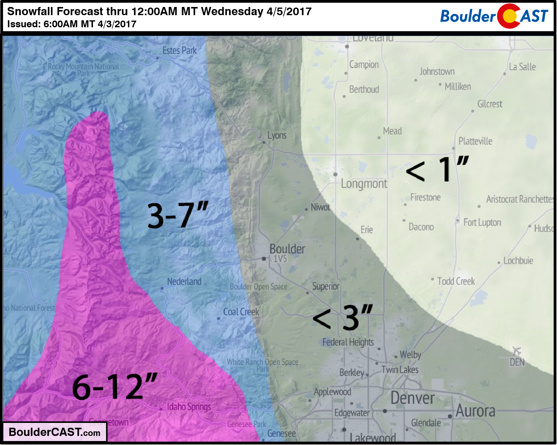
As for amounts, we are forecasting slightly less than the operational models. Sadly, this storm is mostly another “swing and a miss” for Boulder and Denver. Look for 1″ or less north and east of Denver, ~ 1-3″ over Boulder and the Denver Metro, 4-10″ in the Foothills (more south, less north). Our snowfall forecast map is below.
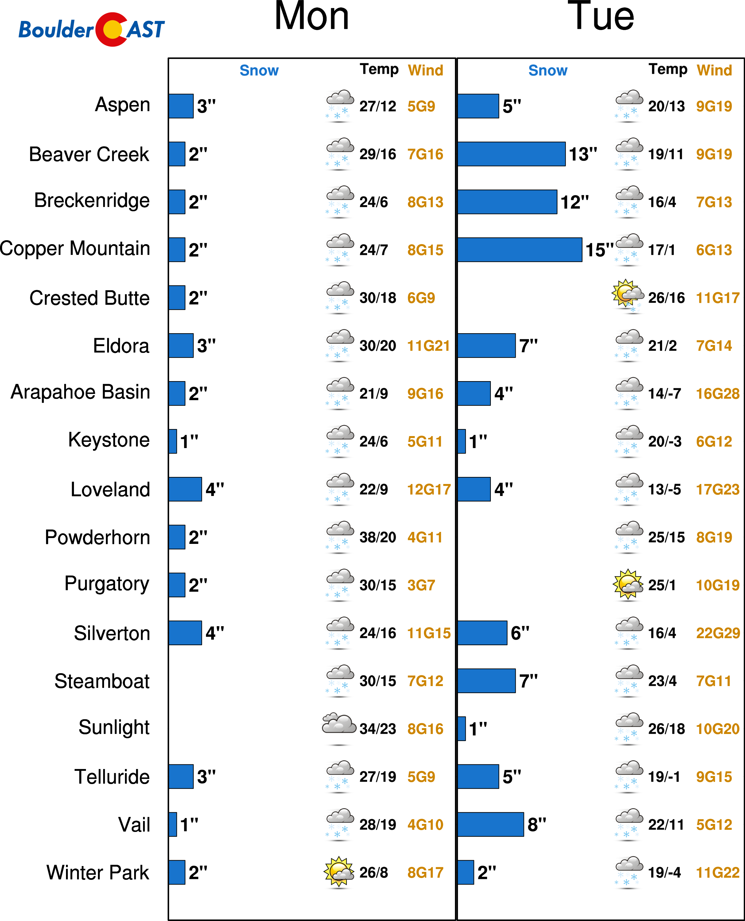
And our latest PowderCAST ski outlook:
Don’t be selfish…share our forecast with your friends!


