
Another late-week system will impact much of Colorado Friday morning through Friday night with light rain turning to snow across the Metro area. With an unfavorable track and limited cold air, snow accumulations will be minimal. We take a look at when the rain will arrive, when it will change to snow, and expected snowfall amounts.
Key Forecast Highlights:
- Partly sunny and mild on Thursday ahead of our next approaching storm system
- A preliminary cold front passes Thursday night ushering in low clouds, fog and drizzle by Friday morning
- A dreary day is on-top for Friday with temperatures in the 30’s to lower 40’s
- Light rain will turn to snow across the Metro area by early evening
- Only minor snow accumulations are anticipated
G
OES-East water vapor imagery this afternoon shows our approaching storm system to the west coming ashore into central California. Ahead of this, a swift-moving hose of moisture associated with the subtropical jet stretches from the Baja in Mexico through Colorado and into the Great Lakes.

Over the next 36 hours, this trough will push closer with the core of the energy moving from west to east during the day Friday across northern Colorado. The approximate track of the storm is shown below.
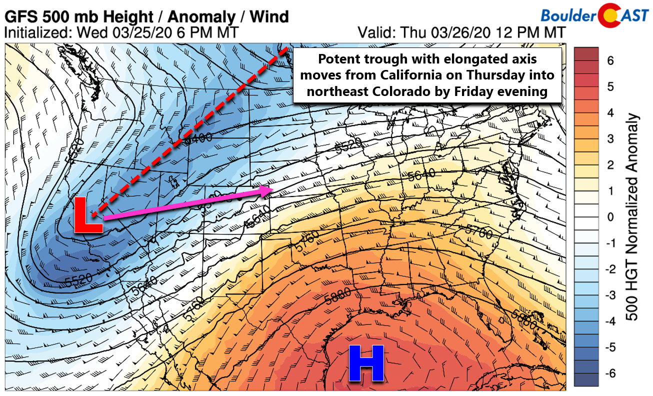
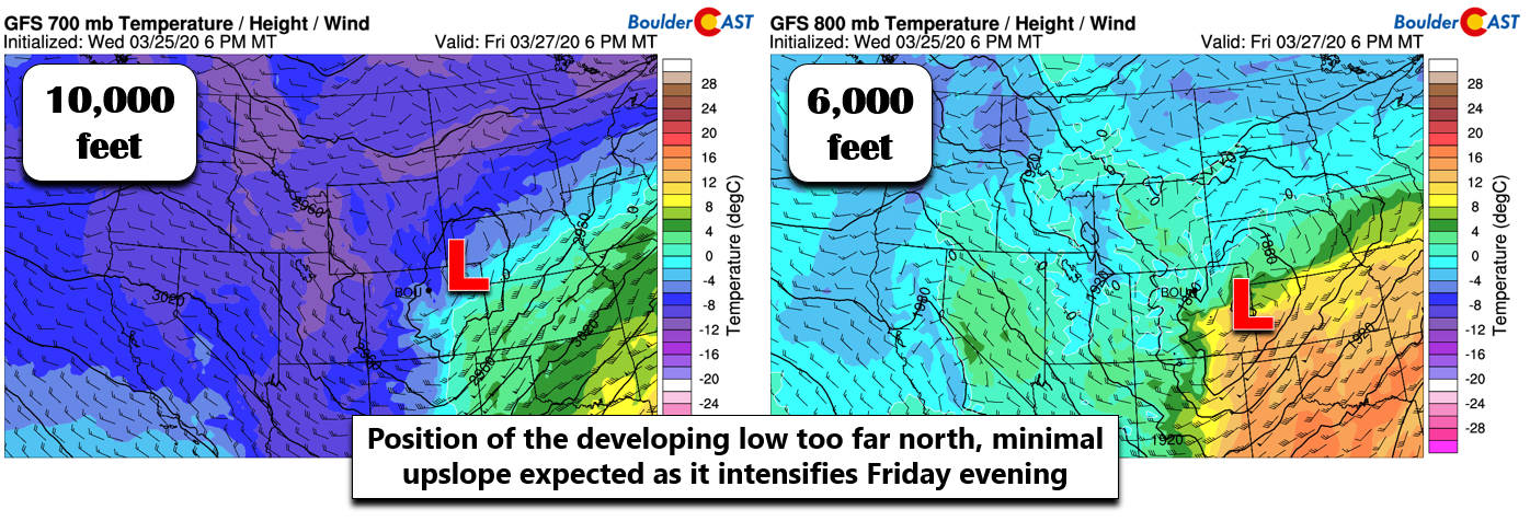
A closed, mid-level low pressure will develop across northeast Colorado Friday afternoon with the surface low further south in east-central Colorado. Overall the track of the system is too far north for significant winter weather across the Front Range. However, lift from the trough and shallow northeasterly upslope will work in tandem to produce a period of generally light precipitation across our area Friday into Friday night.
A cold frontal passage will kick things off across the Denver Metro area late Thursday night. Expect low clouds, fog, and drizzle to develop by Friday morning. This shallow upslope will then persist through the day Friday, especially northwest of Denver in Boulder and Larimer Counties. These areas will remain fairly socked in much of the day with light rain/drizzle holding.
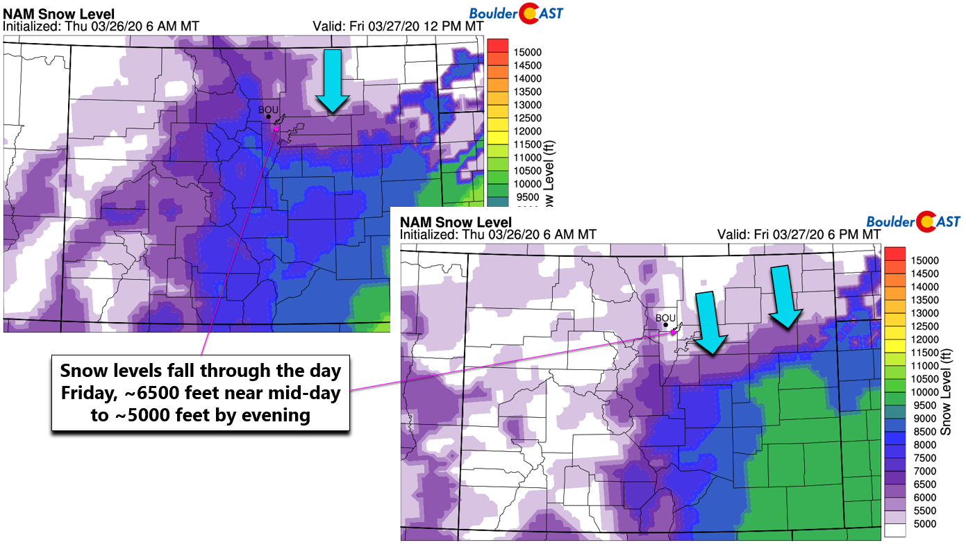
Higher up in the Foothills and Mountains, it will be cold enough for snow at the onset. The BoulderCAST model-derived snow levels are near 6500 feet in the morning and afternoon, falling down to include Boulder and Denver by evening (shown below). Large-scale lift and weak instability will lead to scattered rain/snow showers throughout the day across the higher terrain. There could be a few embedded lightning strikes as well given the vigorous nature of the storm system. Convective snow showers will lead to brief white out conditions in the Mountains, so travel with caution.
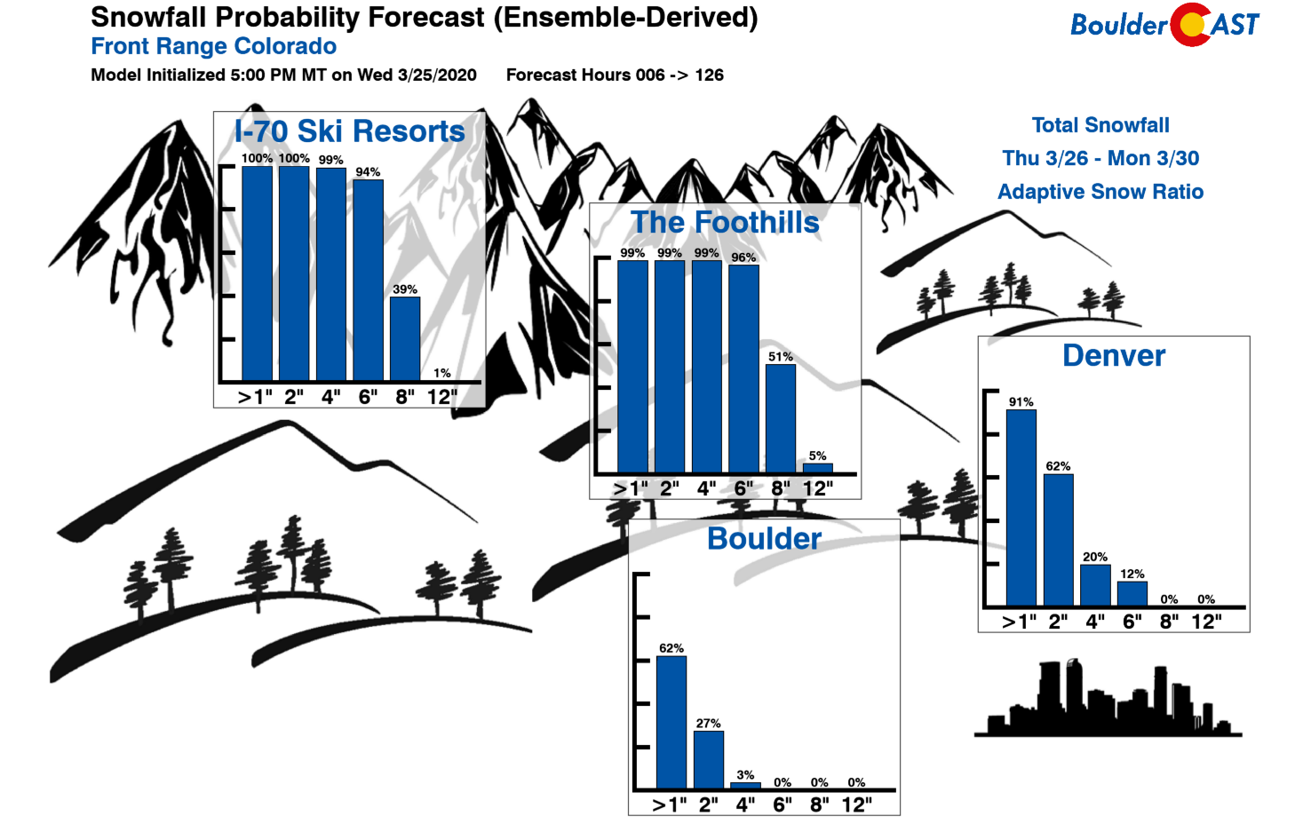
Across the Plains, light rain and drizzle will mix with and change to snow during late afternoon and evening hours. However, the timing will be too late for much snow to stick. As the surface low intensifies across east-central Colorado, downslope will start to kick in over the area (BOO!). The window where lift, upslope, and cold air overlap is rather short. Furthermore, temperatures will only be in the low 30’s Friday evening so what falls will be melting somewhat. With that said, potential snow amounts will be light, less than 3″ for the lower elevations and 2-7″ in the Foothills. Some areas will see nothing stick. Our snowfall forecast map for the event is shown below.

As far as the range of potential snow amounts for this storm, our latest Snowfall Probabilities show very low odds for Boulder to exceed 2″, with Denver having notable but small chances of reaching 6″. This is mainly due to a few outlier model scenarios where the low pressure develops further south and west, clipping east and southeast portions of the Denver Metro area. We consider this outcome too low of a probability to increase our forecast amounts in that area, but do keep this in mind if you’re in the Parker, Aurora, Buckley area.
As you can see, this storm should be but a tiny blip on the radar for us, especially considering the type of snowstorms possible this time of year. March is our snowiest month after all! Look on the bright side, though: at least it is shaping up to be an ugly Friday and we all won’t have to worry about being stuck at home during the quarantine. Outside conditions won’t be all that appealing anyways…
As the strong storm kicks out across the Great Plains producing mainly widespread rainfall on Saturday, quieter weather will set in across Colorado’s Front Range with temperatures remaining near or slightly cooler than normal and just spotty rain/snow showers peppering the higher elevations through the weekend.
From all of us at BoulderCAST, stay warm, stay safe, and stay healthy!
Help support our team of Front Range forecasters by joining BoulderCAST Premium. We talk Boulder and Denver weather every single day. Sign up now to get access to our daily forecast discussions each morning, complete six-day skiing and hiking forecasts powered by machine learning, first-class access to all our Colorado-centric high-resolution weather graphics, bonus storm updates and much more! Or not, we just appreciate your readership!

.
Spread the word, share the BoulderCAST snow forecast!


You must be logged in to post a comment.